Download Agreement, Release, and Acknowledgement of Risk:
You (the person requesting this file download) fully understand mountain climbing ("Activity") involves risks and dangers of serious bodily injury, including permanent disability, paralysis, and death ("Risks") and you fully accept and assume all such risks and all responsibility for losses, costs, and damages you incur as a result of your participation in this Activity.
You acknowledge that information in the file you have chosen to download may not be accurate and may contain errors. You agree to assume all risks when using this information and agree to release and discharge 14ers.com, 14ers Inc. and the author(s) of such information (collectively, the "Released Parties").
You hereby discharge the Released Parties from all damages, actions, claims and liabilities of any nature, specifically including, but not limited to, damages, actions, claims and liabilities arising from or related to the negligence of the Released Parties. You further agree to indemnify, hold harmless and defend 14ers.com, 14ers Inc. and each of the other Released Parties from and against any loss, damage, liability and expense, including costs and attorney fees, incurred by 14ers.com, 14ers Inc. or any of the other Released Parties as a result of you using information provided on the 14ers.com or 14ers Inc. websites.
You have read this agreement, fully understand its terms and intend it to be a complete and unconditional release of all liability to the greatest extent allowed by law and agree that if any portion of this agreement is held to be invalid the balance, notwithstanding, shall continue in full force and effect.
By clicking "OK" you agree to these terms. If you DO NOT agree, click "Cancel"...
This TR has 3 sections, but only one that is useful, that would be Section 3. So, feel free to skip my usual, lengthy, commentary.
Section 1: Background info with little relevance to...anything
After a long winter of volleyball (watching, not playing), I kept my longing for the peaks at bay by pouring over countless topo maps and making an unrealistic list of peaks to try this year.
As I proudly reviewed my list, I realized that "watching" volleyball and "perusing" topo maps does very little to get one in shape. And with my over zealous list staring back at me, it was clear that I needed to get the gams moving...and soon.
With limited time and higher than expected snowfall for April, I decided to stay local and explore some of the peaks near Manitou Springs.
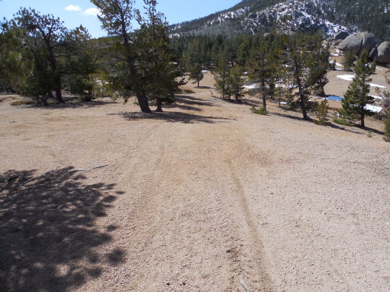
Cameron Cone, seemed like an ideal peak to venture up. 4000+ ft elevation gain in ~3.5 mi (give or take) and one could add on Sheep Mtn and Marys Mtn with other peaks for a nice, lengthy, loop (and decent elevation gains/losses), if daylight and desire allotted. Camerons Cone from near Rocky Mtn (AKA Eagles Nest)
Section 2: MY Trip Up Cameron Cone
Every account I'd read about Cameron Cone from the Englemann Canyon side, had 2 common themes, "route finding could be an issue" and finding and following some mythical trail was key to enjoying your day.
I read TRs and talked to a few people who knew of this "trail" (some never found it), but descriptions and waypoints of where to get on the trail varied. I kept thinking, "how hard can this be?" One other common theme was, if you find the trail, you will lose it at times...perfect. (BTW, kudos to the person that wrote up the route description on summitpost and the additional comments, very helpful.)
So armed with a smattering of waypoints and differing descriptions of creek crossings, train tracks, utility poles, etc. I left my car and headed up Ruxton Ave. I crossed the creek on the nice foot bridges (don't bother with the rock hop as some describe) and took a climbers trail up to the Cog RR tracks. I then looked for a utility pole with the #044954, as mentioned in the comments on SP...only I'd forgotten to bring the pole number and apparently failed to memorize the 6 digit number...but I did remember that it had a '4' in it.
When I got there, I saw many poles...each with a '4'....
I picked one (#048724) and found a well used climber's trail across the tracks, heading straight up, as per the description. This must be it and I headed up. Whatever I was on was certainly well used, but soon it headed into a thicketed, impassable, pile of boulders (the first of many I would encounter on this day). I looked around and saw 3 gentlemen below, walking along the RR tracks. I yelled down and asked if they knew where the actual trail was. One yelled something back in a super cool accent, but I couldn't hear him with the creek and the distance so, I yelled back, "ok thanks" and muddled on....
I found a decent game trail heading off to my right. I took that and soon found an awesome trail! Yay, it's not just Manitou lore!
Life was good, was lovin' the trail, but it wasn't hitting the waypoints I'd entered. Turns out, it was not the correct trail and it suddenly seemed to end in another overgrown boulder filled gully. I looked all around and could not find where the trail went. Good heavens, I was barely into this hike and was already off route (twice), could be a very long day.... Awesome trail! But the wrong trail. This trail just suddenly ends.
I found another game trail that headed towards a waypoint I had. And soon, I was on a great trail again. That was the theme for the 1st part of the hike, "Drats, I lost the trail." "Yay, I found the trail!" "This trail is going the wrong way, now it's going the right way." "Hey, this trail just ends...." What should have been easy and obvious was quite confusing at times. I also heard a few odd noises and my GPS was acting up...geez, throw in some pentagrams and voodoo paraphenalia and we have a poor adaptation of "The Blair Witch Project".
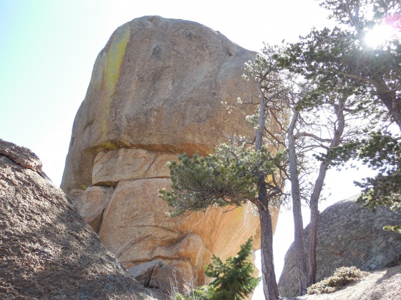
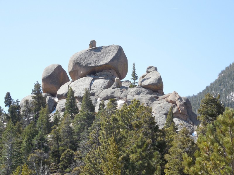
After a few WTFs down low, I soon was on Magog Ridge and my frustrations immediately dissipated. As I passed by Magog and Gog, I was in awe. Pictures don't even come close to doing these guys justice...they are huge and impressive! Magog, this picture doesn't come close to showing how impressive this is.Gog, with Cameron in the background
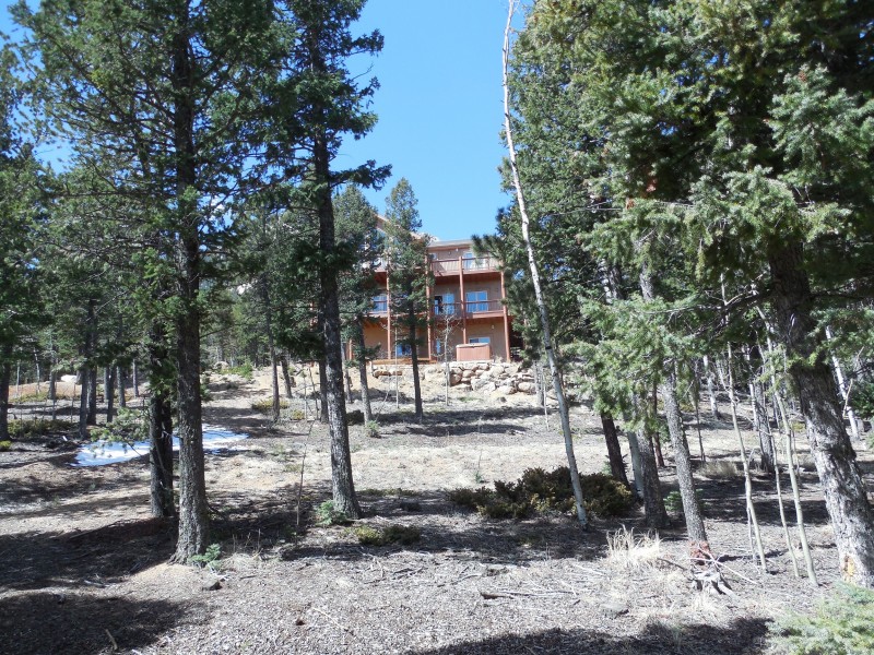
After Gog, I was able to follow a road, but I took it a little too far (due to misunderstanding the route description) and I ended up in a neighborhood...completely unexpected. I backtracked and turned off the road onto a good trail that took me all the way to the summit.
Nice houses near 9k, but you've gone too far.
Much of the trail was buried in snow so, I just followed pink ribbons and the occasional trail segment or cairn peaking through. The last 1500' were steep and slick with snow and ice (even with micro spikes). Whomever built this trail was against switchbacks. On the plus side, one makes some great elevation gains, once you have decent footing.
I finally got to the top and I felt great. The views were gorgeous, of course!
Washed out view of Pikes Peak from the summit
I hung out for awhile, signed the register, ate, took pictures, and started down the north ridge towards Sheep Mtn. Soon I heard voices and saw 3, fine, young, European, men coming up the ridge. One of them yelled to me, "You made it!" I asked about the ridge and one of them said, in a thick Belgian accent, "It was not goot."
The 3 men had set off on a different route than I, lost the trail in the snow, and apparently had no pink ribbons to follow. Long story short, their route had them on the super steep, NE side of the mountain, scrambling on large boulders and post holing in 2-3 ft of snow.
I told them how I had come up and they gladly took note for their descent.
I started heading towards Sheep Mtn, but they discouraged it, due to the snow depth. They were right, it sucked. I dropped ~250' and decided it was taking me too long with the conditions. The words, "It was not goot" kept ringing in my head. You are correct, my Belgian friend.
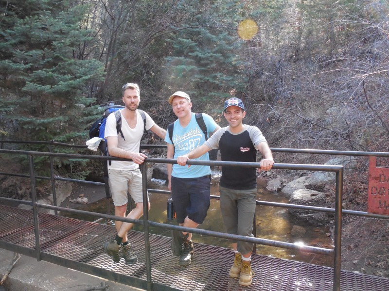
I headed back to the summit, dug the snow out of my boots, and found the 3 amigos (Michael, Jerome, and "Daniel" - sorry, I know this is not your exact name) trying to dry out their socks and boots in the sun.
We (again) talked briefly and I headed down. I got off track and soon heard Daniel call out, "There she is." They got me back on track and in pursuit of peenk ribbons (as they pronounced it), then escorted me down ~1400'. Here they opted to take another trail the rest of the way down and we bid each other adieu.
All was going swimmingly, and I was making great time. Then I got on a part of the trail I was unfamiliar with (since I wasn't on the right trail for the ascent on this section). I followed the trail for awhile, but it did not seem right (I learned later that it was). I backtracked up the trail and soon heard Michael call out to me. I commented how they always find me when I'm off route and they confessed that every time we part, they end up in the wrong direction as well. So we joked that we needed to stay together to keep from getting lost.
With some unconventional effort, we were soon back at the RR tracks, crossing the bridge, and back to my car...where we parted ways...again.
Thank you, Michael, Jerome, and "Daniel" for the escort. You made my trip down much more enjoyable. Hope the rest of your travels are successful! My unexpected company for the descent. L-R Jerome, Michael, and "Daniel"
Section 3: Route Description for Cameron Cone:
Note: This route description crosses the Cog RR tracks which are on private property, the rest of the route is on forest land. If you want to avoid having to cross the tracks, there is a Jones Park route (which will be closed to the public soon), described on SP. There is supposed to be a way to do Cameron from a non gated, community off Crystal Park Rd, but I do not have any information on that.
Parking...parking is tight. Get there early and bring money (both cash and credit card).
Barr Trail lot - $5 credit card only
Cog "hiker" lot - $5 credit card only
Iron Springs Chateau lot - $5 cash only
Manitou, Canon, and Ruxton Aves - Pay stations have been installed, don't have details
Soda Springs Park - Pay stations have been installed, don't have details
Memorial Park - Might remain free
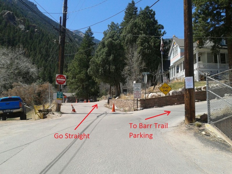
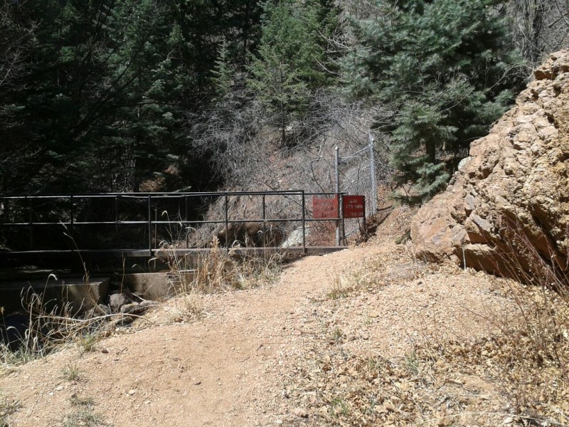
Regardless of where you park, skip heading up Barr Trail (as most descriptions suggest). Just head straight up Ruxton Ave. Go past the turn off for the Barr Trail parking lot and past the houses, until the road ends at 2 gates. This way is much more direct.
Keep going straight up Ruxton Ave
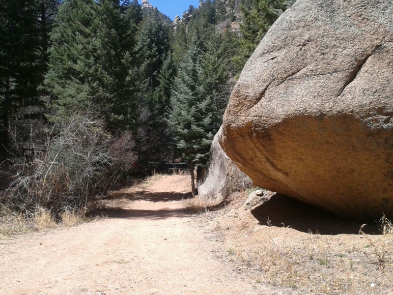
Go around the left (lower) gate, pass some large boulders, and cross the 2 black foot bridges across Ruxton Creek. Take the climbers trail up to the tracks.
Walk past some large boulders to the bridges at the backFirst foot bridge
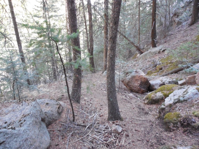
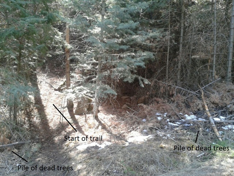
Once at the tracks, walk up the tracks past 1 utility pole and go to the 2nd utility pole (#044954). Cross the tracks here and 3-5 ft to your left, between 2 piles of dead trees/bushes (which may get cleared at some point); look for a hint of a trail. The entrance is a little overgrown and not obvious. Keep looking beyond the foliage, until you see something that looks like it works and there is the trail. Within a few feet of leaving the tracks, if you are not on an obvious trail, then you are at the wrong spot.
Entrance to the Englemann Trail
The trail climbs steeply and has some quick zig zags. When you get on a fairly lengthy straight section (heading to climber's right), watch for a quick switchback going sharply left: (flagged on the map, at N38 50.970 W104 56.544) the trail also continues straight, it's easy to miss. The last time I was up there, someone had laid some branches across the trail to deter passage to the section going straight, but I don't know how long they'll remain there.
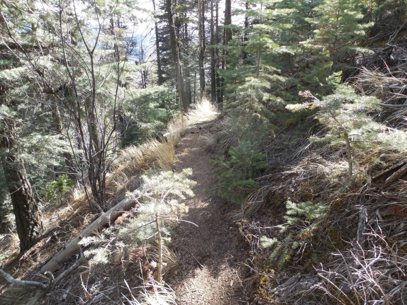
After that, the most confusing parts are behind you. Just keep an eye on the trail, you may lose it at times, but just backtrack and you will find it again.
A view of the excellent trail
Once you get on Magog ridge, pass by Magog Rock on climber's right and find the easiest way to ascend (easy, short, scramble).
Follow the trail and head over to Gog Rock, and pass on climber's left.
Gog Rock
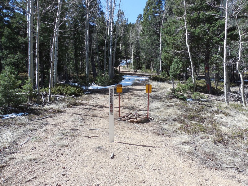
Beyond the Gog rock formation, you will follow a road, keep following it, even when it heads down a little ways. It will feel wrong. When you see an obvious trail on your right (with signs that say "no motor vehicles"), take that. If you come up on a house, backtrack up the road a short ways and look for the trail, it runs behind the house.
Road after GogAnd more road....Leave the road here and take this trail to the summit.
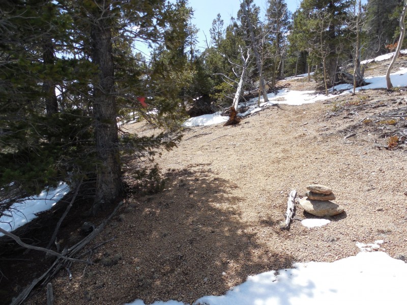
Once you've left the road, follow the obvious trail and look for pink ribbons and cairns all the way to the summit.
The 2nd half of the trail is marked with ribbons and cairns
Enjoy!
My GPS Tracks on Google Maps (made from a .GPX file upload):
Reading your report reminded me of several things that happened to me last year: getting off route a few times, meeting up with some huge stone monoliths, and meeting a few European vacationers -- in my case, 2 young ladies from Italy.
I'll be out to CO again the last two full weeks in July. Shoot me an email if you want to know my tentative itinerary. Would love to do something together again if it would work! :D
I got a little obsessed with figuring out the lower section of the trail and went back to find it. Was hoping to help others avoid the pitfalls I encountered.
I beg to differ re: sections 1 and 2 not being useful. They were useful to me, in that they entertained and amused me on this dull Thursday morning in my cubicle. :)
It took me a few years to try this and finally did last September. Those rocks are very impressive. You need some sort of reference to understand the scale. Also, that last 1500 feet with the pink ribbons is no fun in the summer. It is steep and on loose scree, but I have to admit, the views from the top are some of the best in the Pikes Peak area.
Yes, although unexpected, the 3-dude escort service was welcomed company on the descent. Much better than listening to myself cuss on the ascent.
Definitely needed something for perspective on those rocks but I couldn't come up with anything at the time...other than more rocks :oops: Too bad those 3 guys had ditched me for this section. :wink:
MtnHub - PM or email me, would like to join you again when you come out this summer.
And here, all along, I thought you were making up the 3 male escorts..... :lol:
If you are ever wanting to get back up there, let me know. I've eyed Cameron's Cone literally dozens of times running down the Barr Trail and have wondered about it's route. I need a nice, steep, early season butt kicker.
It seems like there are many ways up Cameron Cone. I wasn't aware of a trail coming up the s.e. ridge. The easiest trail is up the n.e. ridge. The terrain is very confusing in the area even if you have been up there before. Good report, Valerie!
to the very limited available information on this peak; thanks! Very sad to have it confirmed that they are now charging for parking at the Barr TH, and that the closing off of Jones Park seems to be a coming certainty, but the updated info is appreciated. Roughly how many names were in the register??
Hard to say how many names, but more than I expected. Sorry, I didn't really pay attention, probably 5-7 pages rolled up in the plastic jar, rather full, front and back. People signed whereever and not in chronological order. The earliest year I saw was probably '09. I guess 5-10 signatures per side of paper?
Thanks for the trip report, and all the route description info! I was pretty hesitant to try the hike because of all the route finding issues I heard about, but after reading your report, it didn't seem too bad. Thanks for including the gpx file, too. It was very helpful to look at it on google earth to familiarize myself with where the route went. (don't have a gps, otherwise I would have followed it on there). Starting out from the tracks, I immediately found the trail, but accidentally took a lower trail. Eventually I had to bushwhack a bit, but was able to find the higher trail. There's lots of junctions after there..!! (or maybe it's just social trails that reconnect). So I was a bit hesitant, but was still able to make it to the top! The cairns and ribbons definitely helped a ton for the area above Crystal Park.
As a side note, I was wondering if you could change the title of your trip report to Cameron Cone. (singular, not plural). When I searched for trip reports for this mountain, yours didn't even show up at first. :/ I was only able to find it through another author recommending your report. Thanks!
Here's a link to show that the singular is indeed the formal name. :)
All Trails has it now and I fixed the peak name 12/15/2023 7:10am
Hi Dale,
Since they've redone the tracks, I'm sure the piles of debris are no longer there. Also, the last time I was up there, I hardly saw any pink ribbons, they may have been removed or have fallen off over the years.
If my gpx isn't useful (someone said it was a bit mangled when they loaded it?), Alltrails has it now.
Good luck, it's a great workout!
- Valerie
Caution: The information contained in this report may not be accurate and should not be the only resource used in preparation for your climb. Failure to have the necessary experience, physical conditioning, supplies or equipment can result in injury or death. 14ers.com and the author(s) of this report provide no warranties, either express or implied, that the information provided is accurate or reliable. By using the information provided, you agree to indemnify and hold harmless 14ers.com and the report author(s) with respect to any claims and demands against them, including any attorney fees and expenses. Please read the 14ers.com Safety and Disclaimer pages for more information.
Please respect private property: 14ers.com supports the rights of private landowners to determine how and by whom their land will be used. In Colorado, it is your responsibility to determine if land is private and to obtain the appropriate permission before entering the property.

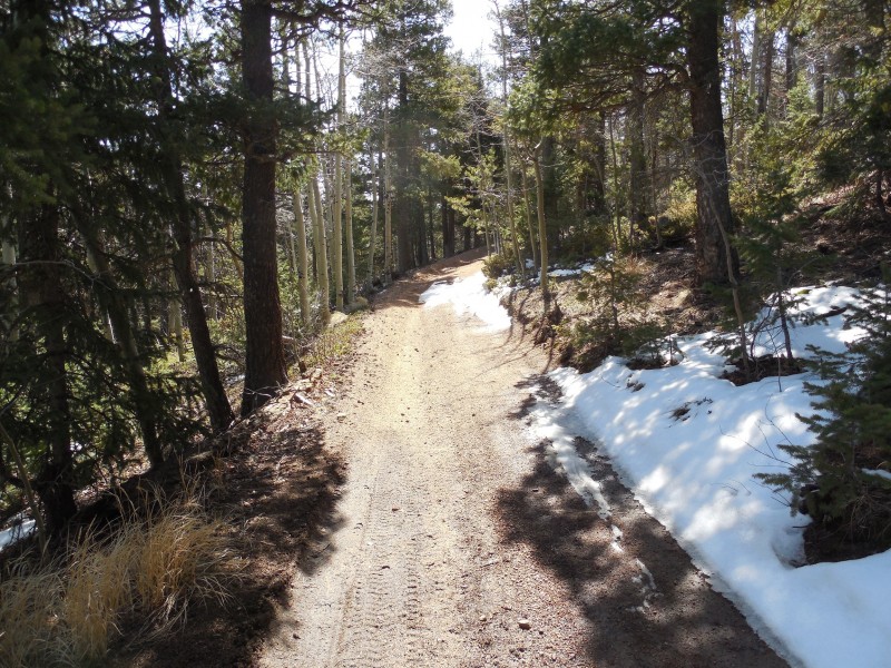
 Where there was snow, ribbons led the way")


