Download Agreement, Release, and Acknowledgement of Risk:
You (the person requesting this file download) fully understand mountain climbing ("Activity") involves risks and dangers of serious bodily injury, including permanent disability, paralysis, and death ("Risks") and you fully accept and assume all such risks and all responsibility for losses, costs, and damages you incur as a result of your participation in this Activity.
You acknowledge that information in the file you have chosen to download may not be accurate and may contain errors. You agree to assume all risks when using this information and agree to release and discharge 14ers.com, 14ers Inc. and the author(s) of such information (collectively, the "Released Parties").
You hereby discharge the Released Parties from all damages, actions, claims and liabilities of any nature, specifically including, but not limited to, damages, actions, claims and liabilities arising from or related to the negligence of the Released Parties. You further agree to indemnify, hold harmless and defend 14ers.com, 14ers Inc. and each of the other Released Parties from and against any loss, damage, liability and expense, including costs and attorney fees, incurred by 14ers.com, 14ers Inc. or any of the other Released Parties as a result of you using information provided on the 14ers.com or 14ers Inc. websites.
You have read this agreement, fully understand its terms and intend it to be a complete and unconditional release of all liability to the greatest extent allowed by law and agree that if any portion of this agreement is held to be invalid the balance, notwithstanding, shall continue in full force and effect.
By clicking "OK" you agree to these terms. If you DO NOT agree, click "Cancel"...
The Full Monty - Clark Peak traverse from Montgomery Pass
A ridgeline range traverse over several unnamed peaks to Clark Peak in the Rawahs.
Stats:
- 8 summits : PT 11161, PT 11622, PT 12170, PT 12184, PT 12386, PT 12390, PT 12433, Clark Peak (12,951 ft - highpoint of Medicine Bow Range)
- Total mileage: 17 miles round trip. Total elevation gain: 6300 ft. Round trip time: 9 hours.
Elevation gain from trailhead to Clark Peak - ~5000 ft. Time: 4 hrs.
Return time from Clark Peak: 5 hrs
A week after climing Longs and Meeker, I opted for what I figured would be an 'easier' day, based on finger spacing and looking at a topo map. Figured on an 8 mile RT day and 2-3k vertical looking at the topo. I didn't find any information on this route but had been eyeing this ridgeline traverse for a while. Anyway, it ended up being much tougher, especially breaking in a new pair of boots.
Most of the traverse seen this past winter from Long Draw Rd: the peaks seen in winter
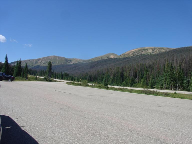
View from the trailhead (Zimmerman Lake) view from trailhead
I started from the Zimmerman Lake trailhead around 11am or so, after being out late drinking the night before, and the long drive up Poudre Canyon, and thinking this would be a shorter day. The weather forecast that day was great - cold front had moved in and there was no monsoon, just a crisp, breezy day. I headed up the Montgomery Pass trail and made good time to the pass in 45 minutes or so. At which point I realized Clark Peak was over 6 miles away and not the 2 miles I estimated from the map. Undeterred, I proceeded onward.
I saw one guy camping up there at the pass, and no one else the whole day. I headed up towards a weather station atop the second mountain, a bit of a surprise to see in this area.
Most of the hiking was on soft, spongy class 2 tundra, with a bit firmer ground earlier on. Past the weather station, the ground got softer, with less gravel. Before that, it's a faint jeep road hitting the pass from both sides and to service the station. There were signs of previous travels up here, and very faint paths. Each of the unnamed summits had a substantial cairn. The beetle kill in the Rawahs below and to the east is really bad.
Each peak in succession had more vertical and was steeper than the last. Towards the middle they became pretty challenging - the soft ground didn't help for my traction. But I kept pushing on, following the ridgeline proper each way, circling a couple bowls, and eventually hit some firmer ground and rocks a peak or so before Clark Peak. I made the Clark Peak summit at about 3pm, 4 hours after starting. After the usual summit rituals of views, signing register, taking photos and eating, I started to head back. I looked over at Lewis Peak but decided to save that for another day given how late it was and how much I did already.
Heading back down south off Clark Peak, I spotted a faint trail that seemed to bypass one of the mountains and skirt around it. I took this, figuring it was indeed a bypass and would save me re-gaining all that elevation. Well, it started to funnel down west towards Colorado State Forest after a while, and i realized it seemed to be heading down that way and not back to where I needed to go. I ended up below treeline, and felt I had to go back up and turn back east. Here I encountered rougher terrain and bushwhacking, and a trail of sorts that seemed to go down to a campground in the State Forest. I headed the other way, rounded a corner, and spotted the weather station on the ridge - waayyy off in the distance, seemed like 3 miles. Great! I was much farther off route than I expected, but at least I had a landmark to aim for.
The traverse over was a bit rugged - I lost quite a bit of elevation, bottoming out around 10,700 ft or so, having to find a way down across a deep gully/old streambed, across talus, then up through thick forest back to treeline. It was a scenic area but slow going. I felt I was following moose trails much of the way. Wary of startling a moose in the thick forest, I eventually made it back around treeline, below the ridge I had climbed on the way up. I found my way back to the ridge and the weather station, and sucked up the remaining minor uphills on the way back to the pass. Within sight of Montgomery Pass, I ran downhill the last couple miles to make it back to the trailhead around 8pm, just before dark. I had run out of water but got a bottle on the way back. I got home to find my feet a bloody mess in new boots that would take months to really break in, was tired, but otherwise ok.
Aside from all this, I really enjoyed the traverse and would recommend it for a challenging day. A bit like Mummy Mania, but a bit lower elevation and a bunch of unnamed points. The routefinding up to Clark Peak is straightforward class 2 tundra. I'd recommend doing this with a car shuttle at the Blue Lake trailhead though, or in State Forest. From Clark Peak you could drop down to that trail and take it back out instead of re-climbing all the ridge twice (and have time to bag Lewis Peak). It's also possible to start from Cameron Pass and add on the Diamond Peaks. Granted, parts of that forest are thick for bushwhacking. And as I found out, skirting the peaks on the way back took more time and energy than just going back up and over them.
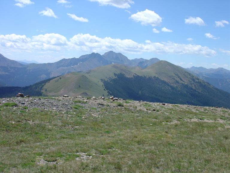
Partway along the traverse, looking back: typical terrain for most of the day
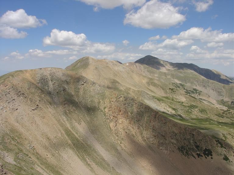
More of what I traversed so far: a look back partway through the traverse
Mt Ricthofen and the Never Summers: Mt Richthofen in the distance
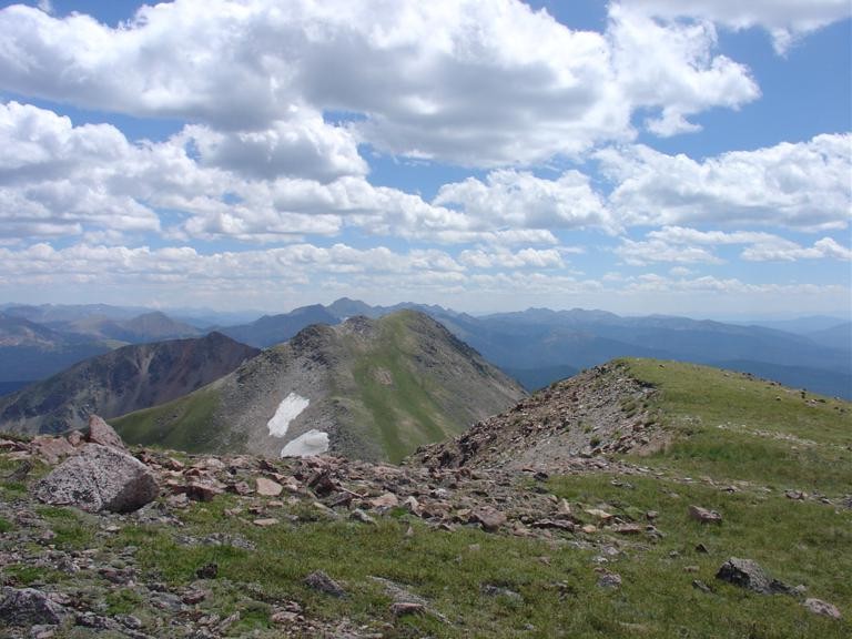
Clark Peak - still a long way away: Clark Peak way back there
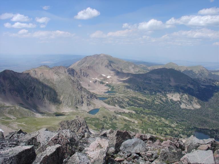
View from Clark Peak summit: Rawah lakes and peaks from Clark Peak summit
View looking back:
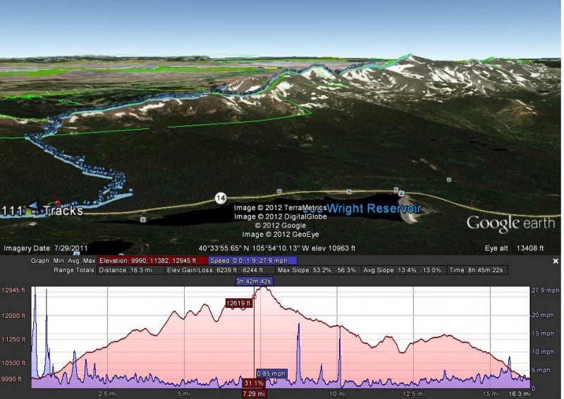
my GPS track: my GPS track gps track
Thumbnails for uploaded photos (click to open slideshow):
The Rawahs and the Never Summers are quickly becoming my favorite local areas to explore. We were up there last year during a very stormy couple weeks, so we had to bag our plans and just do some car camping. Your report has me excited to get back up there now.
Interesting to see that Long Draw Rd gets used quite a bit in the winter. Too bad that even though it's a road, it's closed to motorized vehicles. I just got a dual sport and would enjoy taking it for a ride up there. Maybe it's time I winterize my mountain bike instead. Anyway, congrats on your hike. 17 miles is a long day.
Congratulations, great report and thanks for the beta. I've wondered about that ridge (mostly between the Diamonds and Clark) and it's cool to see that it goes nicely. Is Clark to North Rawah next? =)
I was actually curious as to how that traverse would go but had my eye on points farther north (12,200B in particular). Does the ridge get 'weird' up there or still pretty straightforward? Thanks again!
image 7 (with the lakes) shows the terrain and peaks on the range north of Clark Peak. It looks to get a bit rockier the farther north you go, but I haven't been up that way. I don't think there's anything technical to Rawah Peaks but you can tell from the picture it may be steep and loose in spots.
Continuing on to Rawah Peaks or beyond looks intriguing - about double the distance. May be able to do that and come out to West Branch trail or somewhere up there - that looks to be a long trek. Maybe with a camp by the lakes. Although I know a dude who could run the range all the way to Medicine Bow Pk in a day
PT 12386 is ranked and has 572 ft prominence from its saddle (per LoJ)- that was a bit of work up and down with the soft footing.
Caution: The information contained in this report may not be accurate and should not be the only resource used in preparation for your climb. Failure to have the necessary experience, physical conditioning, supplies or equipment can result in injury or death. 14ers.com and the author(s) of this report provide no warranties, either express or implied, that the information provided is accurate or reliable. By using the information provided, you agree to indemnify and hold harmless 14ers.com and the report author(s) with respect to any claims and demands against them, including any attorney fees and expenses. Please read the 14ers.com Safety and Disclaimer pages for more information.
Please respect private property: 14ers.com supports the rights of private landowners to determine how and by whom their land will be used. In Colorado, it is your responsibility to determine if land is private and to obtain the appropriate permission before entering the property.


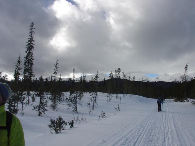


 the peaks seen in winter")
 view from trailhead")
 typical terrain for most of the day")
 a look back partway through the traverse")
 Mt Richthofen in the distance")
 Clark Peak way back there")
 Rawah lakes and peaks from Clark Peak summit")
")
 my GPS track")
 gps track")


