Download Agreement, Release, and Acknowledgement of Risk:
You (the person requesting this file download) fully understand mountain climbing ("Activity") involves risks and dangers of serious bodily injury, including permanent disability, paralysis, and death ("Risks") and you fully accept and assume all such risks and all responsibility for losses, costs, and damages you incur as a result of your participation in this Activity.
You acknowledge that information in the file you have chosen to download may not be accurate and may contain errors. You agree to assume all risks when using this information and agree to release and discharge 14ers.com, 14ers Inc. and the author(s) of such information (collectively, the "Released Parties").
You hereby discharge the Released Parties from all damages, actions, claims and liabilities of any nature, specifically including, but not limited to, damages, actions, claims and liabilities arising from or related to the negligence of the Released Parties. You further agree to indemnify, hold harmless and defend 14ers.com, 14ers Inc. and each of the other Released Parties from and against any loss, damage, liability and expense, including costs and attorney fees, incurred by 14ers.com, 14ers Inc. or any of the other Released Parties as a result of you using information provided on the 14ers.com or 14ers Inc. websites.
You have read this agreement, fully understand its terms and intend it to be a complete and unconditional release of all liability to the greatest extent allowed by law and agree that if any portion of this agreement is held to be invalid the balance, notwithstanding, shall continue in full force and effect.
By clicking "OK" you agree to these terms. If you DO NOT agree, click "Cancel"...
Report Type
Full
Peak(s)
Little Bear Peak - 14,041 feet
"South Little Bear" - 14,028 feet
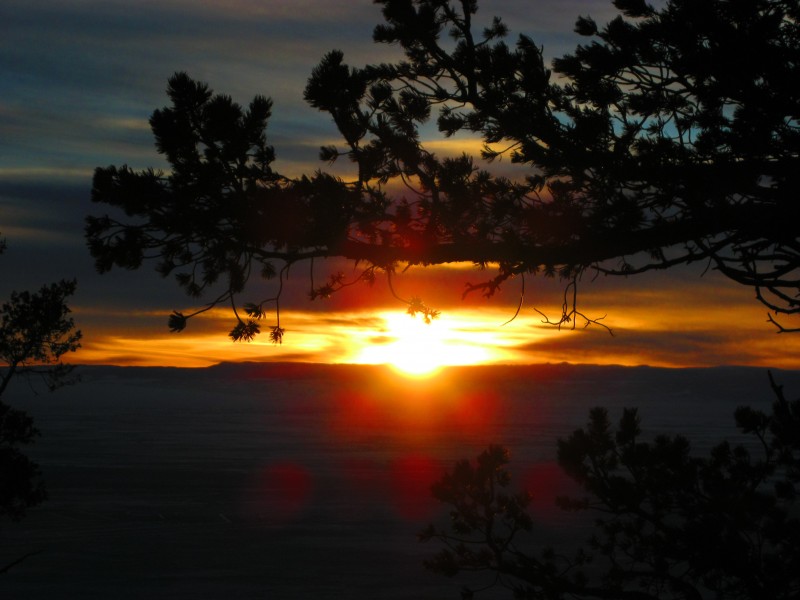
Route Condition Beta at sunset Friday taken from Ft Garland - Photo by Matt
Peak: Little Bear Peak - 14,037', South Little Bear Peak - 14,020' TH/Route: SW Ridge from Tobin Creek Distance: 8mi Elev Gain: 5800' Time: 13:30 (4:45am - 6:15pm) Technical Gear: Microspikes Food NOT brought: Wretched "Core Power" protein drink! Travelers: Geojed (Jed), Matt Lemke, Josh (jswiftcervelo), Sarah (sstratta)
Prologue
Several weeks ago when the "Blanca in Winter 12/29" thread started on the forum Matt Lemke replied to it saying that he hoped to attempt Little Bear that day. I immediately PM'd him expressing my interest in joining him. Matt's friend Josh, the same one I climbed Cronin with, and Sarah Strattan soon signed on. One other guy had a date with some biscuits in NYC or something to that effect. So he couldn't make it.
As the day approached the weather forecast looked about as perfect as it could get: Sunny, ~20F, calm winds becoming SW 5-15mph in the afternoon. This forecast turned out to be spot on. The forecasted low for the morning was below zero so I suggested to Josh and Matt that we stay at the Lodge Motel in Ft Garland for the night ($55/night). This was a wise decision which not only allowed us to sleep warmly but to get completely geared up and prepared in a warm room before getting in the freezing car. We stayed up until 10:30pm chatting about the climb before the prospect of a 3AM alarm finally sent us to sleep with bears dancing in our heads...
Getting There is Half the Fun!
After gearing up and lollygagging while not wanting to leave our nice and warm room, we finally dashed out of our room, started up the frozen car and sped down the highway with the windshield completely frozen/iced over, the heat blasting, dodging deer crossing the highway, and watching the outside temperature plummet from -3F in Ft Garland to -15F where we met Sarah at the turnoff from Hwy 150. Sarah quickly jumped in our car and we set off along the dirt road to the Tobin Creek TH.
There was about 6" of tracked snow in some spots on the road. Unfortunately, I didn't get enough speed to make it up the rough and steep portion of the road in my Forester the first time, so we had to back down 100yrds to the flat area right before the hill. I gunned the engine in 1st gear and didn't let up on the gas until we had made it all the way to the balmy -9F trailhead. Whereupon, we jumped out of the hot car, hoisted our packs and headed off into the bushes before the cold could get to us.
PHEW!
A Rustling in the Bushes
Josh and Matt led the way into the bushes and trees as the branches tore and grabbed at us. 15min into the hike we concluded that snowshoes wouldn't be necessary for the climb, so we stashed them and recorded a GPS waypoint to remember where they were. Josh was getting warm already so he took a layer off here. We soon reached the Tobin Creek crossing at 9100' and had no problems navigating to the other side of the gully. Now I was getting warm due to the lack of wind so I de-layered down to just my puffy vest and thermal shirt. (I remained dressed as such for practically the rest of the day.) We stayed near the rim of the gully containing Tobin Creek as much as possible until we gained the very steep lower slopes of Little Bear's SW ridge. These south facing slopes were mostly dry helping them pass quickly and in short order we reached the ridge proper @ 10,100'. Sunrise over Culebra from the SW Ridge - Photo by Matt
We stopped here to rest and refuel at a little notch in the ridge. After a 15min break we headed up the ridge with Josh and I speeding ahead and Matt and Sarah behind. Matt was feeling the pain of spending the last 3 months at sea level and having just driven out to Colorado the day before. 30min later Josh and I were nearing tree line at 11,100' where we stopped and waited for Matt and Sarah. There were a couple of snow drifts near here that reached 2' deep but they were easy to break through and once above tree line it was mostly talus hopping for the next 1800'. View towards PT12,900 from Tree Line - Photo by Matt
Still more talus, Josh and I visible near top - Photo by Matt
Here Josh and I gazed on one of the most incredible vistas I've seen in Colorado. I had seen many pictures of this view in TR's while researching for this climb but nothing really prepared me for how dramatically awesome it is in person. The View of Views - Little Bear's West Face Troll Doll Wannabe? Josh with Twin Peaks, California Peak, and Ellingwood Behind
When facing off with The Bear move slowly and don't try to outrun it
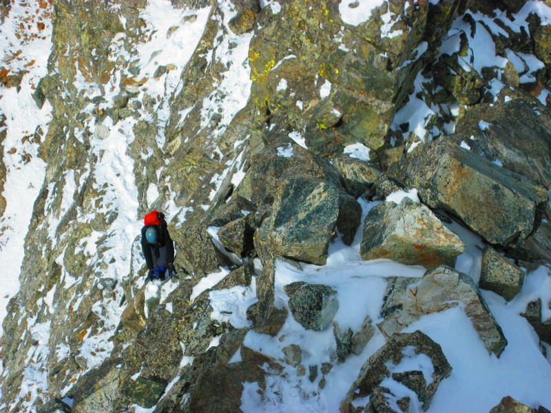
After gawking at the view for awhile and refueling Josh and I set off along the ridge. We found that staying on the ridge crest was easiest as there were snowfields on the south side of the ridge. We cruised past the several bumps and notches on the ridge and ascended the very steep portion of the ridge to within 200' of the summit of South Little Bear and to what turned out to be the crux of the day: The Knife Edge and The VERY Airy Face . We reached the Knife Edge around 10AM. I studied it for a couple minutes. This knife edge has an almost vertical face on the left side while the right side is somewhat less steep. Halfway across it there is a 2ft step UP in the knife edge and then the knife edge continues for another 8 feet or so. On the left is a 1000' foot near vertical drop that would mean instant death, on the right you would probably tumble for 1000-2000' before stopping. I didn't want to contemplate the results of either option so I got my balance and made two big steps across the lower knife edge to the 2' step. I then grabbed the crest of the upper knife edge with my hands and swung my knee up on the step and then my other knee. I scooted the next 8' with my hands on the edge and my knees against the rock. Josh Contemplating The Knife Edge
10' after the knife edge there is another obstacle that rivals the knife edge in difficulty and pucker factor. A chute comes in from the right and forms a 2' long notch where the ridge basically disappeared beneath my feet. Across this notch there is a 6' high wall that lacks great handholds and footholds. I studied this face for a couple minutes testing out a mediocre foothold for my right foot. I concluded that if I put all my weight on that foot then my foot was going to slip and who knows what would happen next. I stepped back a bit and then noticed a nice 4" wide, snow-dusted step that was to my left. I hadn't seen this step before because why would I look for steps that had nothing but 1000' of air beneath them? It was a solid step nonetheless and I used it to swing my right leg up over the face and finally reach a good handhold that would get me over this obstacle. PHEW! Adrenaline was definitely pumping now! Home Stretch to South Little Bear - Photo by Matt
Once finally across these obstacles I tuned back to help direct Josh across them. He had gotten out his ice axe to hook it on the knife edge as an anchor. He then attempted to scoot across the lower knife edge with his knees against the rock but wasn't comfortable with his handholds. He then tried to saddle the knife edge but that was unsuccessful. He then tried to bypass it by dropping 20' down to the right and crossing a snow covered face. Once down there he realized it was pretty much slick rock covered by snow and that there were no footholds or handholds to speak of.
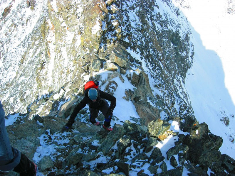
After this last attempt Josh decided that he was going to turn around here as he just didn't feel comfortable with any of the routes to get past this knife edge. I really respect Josh for making that tough decision so close to the summit and not making any moves that he didn't feel totally comfortable with. It's not worth it to get stuck and risk your life. By now, his attempts at getting across had taken about 45mins and Matt and Sarah had caught up to us. Matt and Sarah both put their Microspikes on (something I foolishly forgot to do) and took turns slowly and cautiously facing off with the knife edge and the VERY airy 6' face as I tried my best to direct them past these obstacles. Sarah contemplating the Knife Edge - Photo by Matt
Once past these obstacles we pushed our way up to the summit of South Little Bear by 11:15AM where we had this amazing panoramic view of the other nearby 14ers. We could even see Natalie, Brad and Aaron across the way atop Blanca Peak. Panorama from South Little Bear
Don't get between a Mamma Bear and her Cub
From South Little Bear we studied the Mamma Bear Traverse to Little Bear Peak for 15min or so. We studied the route pictures from Jim's TR and our vantage point gave us the confidence to tackle the traverse as the snow conditions looked quite good. Mamma Bear Traverse
I led the way down to the ledges which was quite easy Class 3 scrambling and then back up to the ridge crest. I picked my way along the ridge crest proper for most of the way to the notch at the top of the Hourglass. There are two spots where I followed a ledge on the left/West side of obstacles. Me Dancing with the Mamma Bear - Photo by Matt
From above the Hourglass notch I descended directly down to the notch via easy Class 4 moves. There was a small 2ft leap of faith I had to make to get down to the snow in the notch. From here I scrambled up a zig-zag ledge on the West side of the ridge back to the ridge crest. Soon after this I reached the summit of Little Bear Peak and let out several yells of delight that echoed off the nearby cliffs. When I looked at my watch at Little Bear's summit, I was startled to realize that the Mamma Bear Traverse had only taken me about 20-25min to cross. All the other TR's said it had taken them from 45min to 1hr to cross but the moves and routes seemed very intuitive & logical for me and the adrenaline from the excitement of the situation must have driven me across at such a quick pace. Looking across the West Face of Mamma Bear Traverse
I immediately put my down puffy parka on and began to refuel as Matt and Sarah continued across the traverse. Sarah navigating the traverse. 2000' drops on either side - Photo by Matt
20min later Matt and Sarah reached Little Bear's lofty summit and we rejoiced together in climbing such an awesome mountain by such an exhilarating route on such a wonderful day. Success! Blanca and Lindsey behind Sarah with the smile that comes with an amazing day in the mountains
What Goes Up Must Come Down
After resting on the summit for 20min or so we began our trek back across the Mamma Bear Traverse. The climb up from the notch was easy and reversing our tracks back to South Little Bear went quick. Once there I watched and took pictures of Matt and Sarah as they navigated the traverse. Can you find the climber? Looking back across the Mamma Bear Traverse Tobin Creek Drainage Can you find the Climber? #2 Sarah navigating the ridge A bit of exposure on those ledges Sarah and Matt climbing the last bit to South Little Bear Sarah's last steps to South Little Bear
Matt said that on the traverse back across he began hallucinating and seeing colorful bears dancing around him due to his altitude sickness. Something like this I imagine...
We knew we couldn't relax yet as we still had to get back across the last two obstacles of the day: the 6' VERY airy face followed by the knife edge.
Sarah studying the knife edge Sarah traversing the upper step of the Knife Edge
Once past these two we could relax somewhat and just be wary of wobbly boulders that would move/tilt/roll under your foot when we stepped on them. Well wouldn't you know, I barely put pressure on one boulder right on the ridge crest that slid & rolled a couple feet right to the cliff edge. Seeing this loose boulder so near the cliff edge I loudly declared "Let the trundling begin!" I put my trekking poles down and made sure I didn't do anything stupid to make me go with the 200lb boulder as I pushed it over the cliff. It plummeted 100' feet through the air where it hit a ledge and exploded into a thousand pieces that crashed and careened 1500' down the cliff face to the snowy talus slopes below. That was cool!
Following this exciting interlude we continued to make our way down the SW ridge. Sarah descending the SW ridge
Matt went at his own pace down the ridge as I stopped often to admire the always incredible west face of Little Bear and take pictures of Sarah as she descended the ridge. Matt descending the SW ridge Great light on Little Bear West Face Sarah on the SW ridge with dramatic cliffs behind Sarah with Little Bear behind Sarah along the SW ridge. Me with a smile a mile wide! Sarah poses with Little Bear
Matt found Josh down near tree line and hung out with him until Sarah and I caught up. We then continued down the ridge into the trees, racing the sunlight, while following our footsteps in the snow and making great time down towards the notch we had rested at in the morning. This was some of the most treacherous descending as the powdery snow on the slippery rocks made a bad combination. Pretty trees along SW ridge
We made it down to the notch just as the sun was setting across the Alamosa Valley. Gorgeous sunset amongst the whispering pines.
We followed our tracks back through trees and bushes along and across Tobin Creek. Having our tracks in the snow to follow made it much easier to make it through the bushes and trees as we didn't have to re-bushwack our route down. Along the way, we began meticulously searching for Sarah's ice axe which she had noticed missing around 9400' on our ascent. Fortunately, Sarah finally spotted it hanging in a bush about 20' after we found our snowshoe stash.
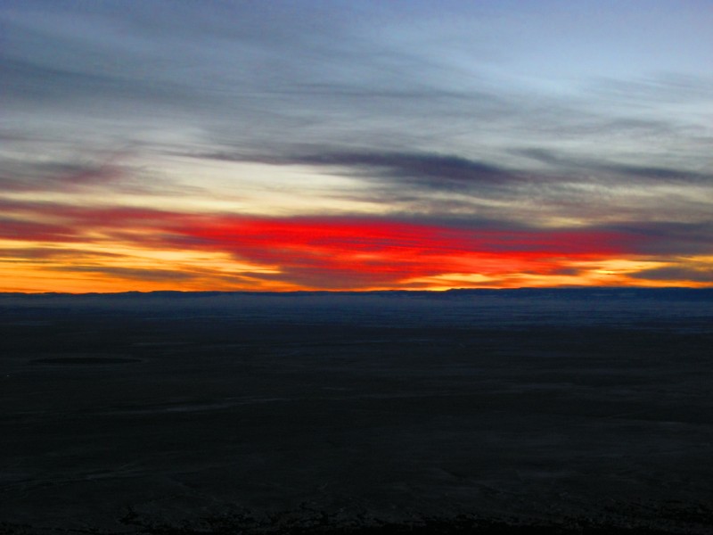
We arrived back at the car at 6:15pm just as the very last of twilight was disappearing. We quickly loaded up the car and headed down the bumpy road. The temp at the TH was now 21F, the temp at Sarah's car was -3F. Gotta love that inversion! Colorful sunset over Alamosa Valley
Sarah headed home from here as she had to get up at 5AM the next morning and Matt, Josh and I headed to the All-Gon Pizza and Pasta Restaurant in Ft Garland where I feasted on a HUGE Lasagna. We sat near a really nice older gentleman who regaled us with funny jokes and serenaded his wife while he played his guitar.
Epilogue on such an Invigorating Day!
The combo of great climbing partners, on an awesome peak, an exhilarating route, with spectacular winter weather made it one of the sweetest days I've had on any peak here in Colorado. Definitely in my Top 5.
To top it off, for some reason, I felt incredible and really full of energy all day. Seriously, not ONCE did I feel tired, exhausted, out-of-breath or lacking in energy even in the steepest sections. I was just in the zone all day. Even at the end it was just my feet and knees were a little sore from the descent. I still felt great!
I really think that if Matt had been feeling better and Josh had made it across the knife edge on the first try then we could have rocked this route in ~12hrs.
Nevertheless, it was a precious 13.5hrs we spent dancing with the Bear and the Bear gave us some well earned "bling" for our efforts.
My GPS Tracks on Google Maps (made from a .GPX file upload):
This went down as probably the most physically demanding climb I have ever done. I won't be climbing hard winter 14er routes the day after coming from sea level ever again LOL!
Thanks Jed for the report. I had a great time despite that miserable descent with a throbbing headache! :oops:
I know you'll probably say that there was no one else out there, and you could see all the way below you, etc., but trundling is never acceptable. It is definitely accelerating erosion, there might be people or animals you weren't aware of (if you're crazy enough to be out there, maybe others are, too...), and could start a massive rockslide. Hate to be Debbie Downer. :?
Actually, from what I have been told, if you come across a rock on a route that is on the verge of falling and poses an immediate threat to future climbers who will come across it, it is actually safer to let it go to potentially save the life of someone on the route after you. At least from what I have been told this is common practice and the ONLY reason trundling is allowed. Obviously if there is a decent chance someone is below you you leave it in place though.
That might be a case where it is ok, but from my reading of the report it doesn't seem to have been a dangling Sword of Damocles, seems more like an opportunity for a 'splosion. Of course, I wasn't there and don't want to point too large a finger.
But I definitely don't want anyone else to think ”hey, cool!”. It's not just ”if there's a decent chance someone is below you then don't trundle”. It should be, ”never trundle unless it will undoubtedly save someone AND conclusively hurt no one and nothing below.”
In most cliffs and trails there will always be loose rocks.
Caution: The information contained in this report may not be accurate and should not be the only resource used in preparation for your climb. Failure to have the necessary experience, physical conditioning, supplies or equipment can result in injury or death. 14ers.com and the author(s) of this report provide no warranties, either express or implied, that the information provided is accurate or reliable. By using the information provided, you agree to indemnify and hold harmless 14ers.com and the report author(s) with respect to any claims and demands against them, including any attorney fees and expenses. Please read the 14ers.com Safety and Disclaimer pages for more information.
Please respect private property: 14ers.com supports the rights of private landowners to determine how and by whom their land will be used. In Colorado, it is your responsibility to determine if land is private and to obtain the appropriate permission before entering the property.


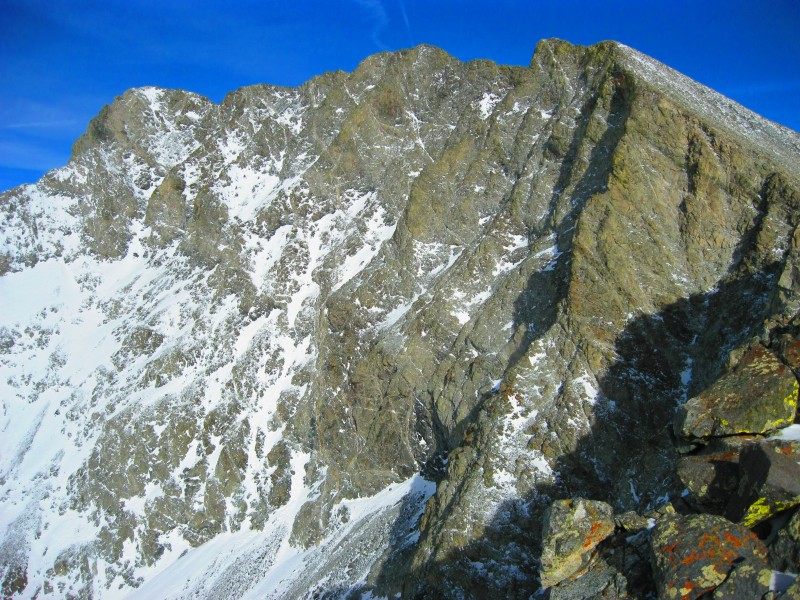
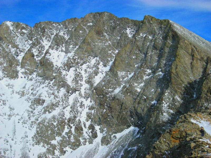


 The View of Views - Little Bear's West Face")
 Troll Doll Wannabe? Josh with Twin Peaks, California Peak, and Ellingwood Behind")
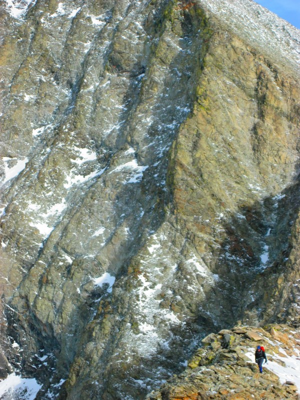
 Precipitous Face of Little Bear")
 Josh Contemplating The Knife Edge")
 Panorama from South Little Bear")
 Mamma Bear Traverse")
 Looking across the West Face of Mamma Bear Traverse")
 Success! Blanca and Lindsey behind")
 Sarah with the smile that comes with an amazing day in the mountains")
 Can you find the climber? Looking back across the Mamma Bear Traverse")
 Tobin Creek Drainage")
 Can you find the Climber? #2")
 Sarah navigating the ridge")
 A bit of exposure on those ledges")
 Sarah and Matt climbing the last bit to South Little Bear")
 Sarah's last steps to South Little Bear")
 Sarah studying the knife edge")
 Sarah traversing the upper step of the Knife Edge")
 Sarah descending the SW ridge")
 Matt descending the SW ridge")
 Great light on Little Bear West Face")
 Sarah on the SW ridge with dramatic cliffs behind")
 Sarah with Little Bear behind")
 Sarah along the SW ridge.")
 Me with a smile a mile wide!")
 Sarah poses with Little Bear")
 Pretty trees along SW ridge")
 Gorgeous sunset amongst the whispering pines.")
 Colorful sunset over Alamosa Valley")


