Download Agreement, Release, and Acknowledgement of Risk:
You (the person requesting this file download) fully understand mountain climbing ("Activity") involves risks and dangers of serious bodily injury, including permanent disability, paralysis, and death ("Risks") and you fully accept and assume all such risks and all responsibility for losses, costs, and damages you incur as a result of your participation in this Activity.
You acknowledge that information in the file you have chosen to download may not be accurate and may contain errors. You agree to assume all risks when using this information and agree to release and discharge 14ers.com, 14ers Inc. and the author(s) of such information (collectively, the "Released Parties").
You hereby discharge the Released Parties from all damages, actions, claims and liabilities of any nature, specifically including, but not limited to, damages, actions, claims and liabilities arising from or related to the negligence of the Released Parties. You further agree to indemnify, hold harmless and defend 14ers.com, 14ers Inc. and each of the other Released Parties from and against any loss, damage, liability and expense, including costs and attorney fees, incurred by 14ers.com, 14ers Inc. or any of the other Released Parties as a result of you using information provided on the 14ers.com or 14ers Inc. websites.
You have read this agreement, fully understand its terms and intend it to be a complete and unconditional release of all liability to the greatest extent allowed by law and agree that if any portion of this agreement is held to be invalid the balance, notwithstanding, shall continue in full force and effect.
By clicking "OK" you agree to these terms. If you DO NOT agree, click "Cancel"...
TH: Montgomery Reservoir--the road was dry to the parking area. The gate was shut just past the bridge.
Trip Logistics: ~10 miles with ~3000 ft elevation gain; 8 hrs roundtrip
So I have to admit, after spending quite a bit of time on the CDT over the summer, I have become a bit obsessed with the Continental Divide. I'm nowhere near ready to commit to a full (or even partial) thruhike, but it's in the back of my mind. When I read Roach's description of Clinton and found out that it is the only Centennial in the Tenmile-Mosquito Range on the Continental Divide, I knew I had to try for it. Roach's statement that "Clinton is a mugwump of a mountain" just sealed the deal. What is a "mugwump" anyway?! Only one way to find out.
I originally planned to hike Clinton's Southeast Slopes and then traverse over McNamee to Traver and descend via Traver's East Ridge. Didn't happen. Actually, I almost didn't summit Clinton Peak either.
Although I've lived in Colorado for quite a few years, I've never summited a high peak in December (or even attempted one). When the snow starts to fall and accumulate in the high country, I cut back on my hiking and increase my rock climbing. This year's snow conditions made it an ideal year for a first December attempt. I've been hiking regularly in the high country this fall, so I knew what the snow conditions would be like. What I didn't account for was the wind...
It was breezy when I got out of the car at Montgomery Reservoir (a bad sign) but I figured I might as well at least hike up to Wheeler Lake. I'm not an ice climber but was intrigued by the ice near the Reservoir:
I was quite happy I had my microspikes as I headed up the 4WD road. The ice is not continuous (some parts of the road are quite dry) but it would be difficult to avoid without some willow bashing:
As I got closer to Wheeler Lake, I kept my eyes open for a good route up the slope. Since I was by myself, I decided to stay off the deeper snow and stick to the rocks as much as possible. This is the slope I headed up, with some scrambling (optional) at the top:
After you pass this first obstacle, the route mellows out for awhile. And that was where the wind found me.
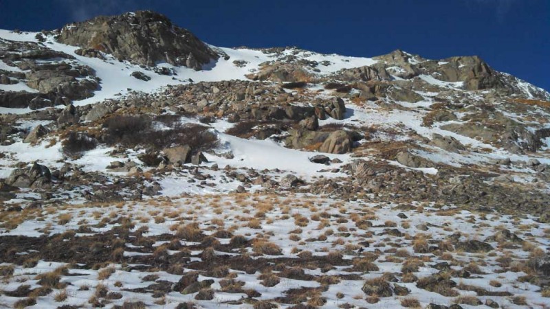
Given the wind, I knew the traverse was likely to be out for me. The decision remained: which peak should I go for? The East Ridge on Traver looked good--mellow, mostly snow-free; maybe I should just go for that. I stayed high in the basin (edging towards that East Ridge) as I tried to make up my mind. Then Clinton's Southeast Slopes came into view and I knew I had to try for Clinton:
I headed over to Clinton's talus-covered Southeast Slopes. The talus was fairly stable but will move if you aren't careful. I could see snow blowing above, but I was still fairly sheltered:
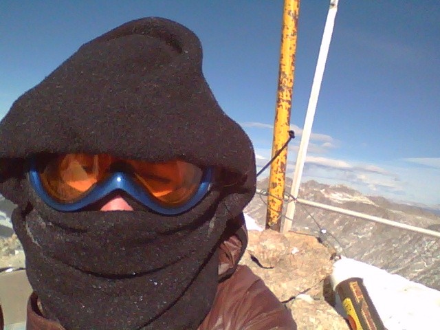
And then I was suddenly thrown to my knees. Hmm. What just happened? I got up, steadied myself and got blown over again. Well isn't this fun? I straightened up again to look for a good route and was blown back over. Getting to the summit was going to be interesting. Now, the wind was not constant, so I couldn't anticipate the gusts. One minute I could walk or stop to look and the next I'd go down. I finally gave up and kept a lower profile by keeping my hands on the ground as I walked. At around 13,600 ft, I started to question if going up was the right course of action. I was nearing the saddle, and if I couldn't stand below it, would it really be a good idea to proceed? I seriously considered turning around (and would have had it been colder--luckily the temperature was fairly high, it was just very windy).
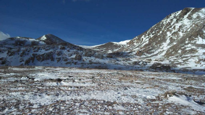
When I reached the saddle, I was pleasantly surprised to find that I could actually straighten up and walk (the wind was much more constant, so I could lean into it). My pockets were rapidly filling with the snow that was being blown around, so I wasn't sure if my pictures would turn out. They did, so here are some views from the summit:
I wanted to traverse to Traver but the wind was just too much. I quickly packed up and turned around, as I wanted to get off the ridge as soon as possible:
Maybe I could just go to McNamee?
Bam--blown over again. Guess I'll just head down. But Traver looks so close:
Another gust of wind gets me while I look at Traver. Still I consider it. I finally decide to go down given how much energy it took to fight the wind up Clinton, the fact that it was early afternoon (and I'd rather not hike the icy road in the dark), and the clouds that were coming in. The weather wasn't threatening, but I knew a storm was coming in tonight. Once I reached the 4WD road again (with occasional strong gusts to keep me honest), I decided to make the short trek to Wheeler Lake. Not sure if this ice is climbable:
Wheeler Lake is mostly frozen:
It took awhile to get down the road with some careful navigation of the ice, but I finally got back to the mining buildings. I tried not to think to much as I passed under the loudly groaning building:
Silverheels kept calling to me:
As I got into the car, the snowflakes began to fall. I would have liked to have done Traver and McNamee as well, but as I drove away and saw the summits going into the clouds, I knew I had made a good choice.
Thumbnails for uploaded photos (click to open slideshow):
were really what got me. I've hiked in strong, constant winds before but have never been knocked over so many times. I checked the weather forecast the night before and didn't see any indication that the wind would be as strong as it was.
Did you see the helicopter? (I think it was coming from the southwest--got knocked over by the wind when I turned to look at it) I was impressed that it could fly in those conditions!
I was up on Democrat and Cameron most of the day and fought the winds as well. The winds got so bad I ended up ditching Lincoln and Bross and heading back down to Kite Lake from near the Bross/Cameron saddle. I am willing to bet the winds at the ridge were 60 sustained with 75MPH gusts around 2:00PM.
Caution: The information contained in this report may not be accurate and should not be the only resource used in preparation for your climb. Failure to have the necessary experience, physical conditioning, supplies or equipment can result in injury or death. 14ers.com and the author(s) of this report provide no warranties, either express or implied, that the information provided is accurate or reliable. By using the information provided, you agree to indemnify and hold harmless 14ers.com and the report author(s) with respect to any claims and demands against them, including any attorney fees and expenses. Please read the 14ers.com Safety and Disclaimer pages for more information.
Please respect private property: 14ers.com supports the rights of private landowners to determine how and by whom their land will be used. In Colorado, it is your responsibility to determine if land is private and to obtain the appropriate permission before entering the property.


")
")
")
")
")
")
")
")
")
")
")
")
")
")
")
")
")
")
")


