| Report Type | Full |
| Peak(s) |
Longs Peak - 14,259 feet |
| Date Posted | 08/10/2006 |
| Modified | 10/01/2012 |
| Date Climbed | 08/10/2006 |
| Author | summitbound |
| Longs Peak-Key Hole Route |
|---|
Due to crazy schedules for both LOVENIT and me it had been over 2 months since our last 14er hike. We were finally able to settle on an agreeable date, Aug 10. The only decision was what peak to climb and there really was not much of question what one we had to get under our belt. I had been fascinated with Longs Peak for quite some time. It was the last of the "visible" Front Range 14er that we had not yet climbed. I had read all the trip reports and studied all the photos. How could anyone not be enticed by a climb that has sections like the trough, the narrows and the home stretch? 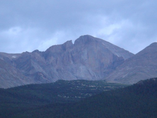 We met up in Estes Park the night before, grabbed some pizza and downed a pitcher of brew before heading up to the trailhead. We had to stop and take a picture of this magnificent peak along CO7. I had read that car camping is not allowed at the parking lot but we decided to take our chances. We were able to throw out our bags in the back of LOVENIT's truck with no problems and we saw several other people crashed in their cars. I was slow to fall asleep due to all the anticipation built up in me and I lay awake well into the night. We overheard conversations from people who had taken over 18 hours to do the entire trip. The main complaints we heard were about running out of water so I made a mental note to throw in an extra bottle just to be on the safe side. We heard people as early as 1am heading out for the summit, the car next to us was on the trail by 2am We stuck with our plan and left at 4am, a quick scan of the trailhead register showed that over 60 people were ahead of us on the trail. It should be noted that there is an ominous sign at the trailhead that reads "55 people have died on this peak...are you next?" I think we were both so excited about this hike that we had pure adrenaline pumping in our veins. We set a blistering pace all the way up to tree line. I did not keep track of how many people we passed but it was well over 20, some of whom had left as early as 2am. We passed a group of teenagers dressed only in shorts and sleeveless shirts on their way back down. We inquired as to if they had made the summit already. They said no, they had left at midnight reached the keyhole and were so cold by that time they turned back. I had to wonder exactly what they expected the temperature to be at midnight on a 14er.....oh well. By the time we reached the top of Granit Pass the sun was starting to come up and we were treated to a spectacular sunrise. 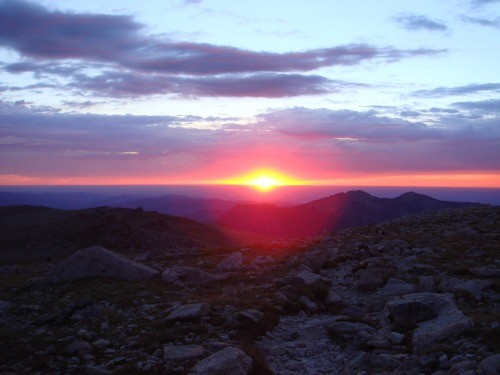 Shortly after that we reached the camping area in the boulder fields. We were unsure what the route beyond they keyhole was like and were not eager to find out in the dark so stopped for a bit to eat and some hydration. And you can tell from this picture how the boulder field gets its name. 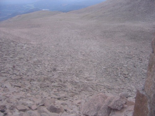 The keyhole is a cool overhanging rock right at the top of the boulder fields that also has a rock shelter near it. 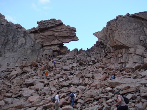 As you pass through the keyhole this is the point where you realize the hike is over and the climbing has begun. It's not nearly as "bad" as I had built it up to be in my mind, but many people chose this point to turn back. The route from this point forward is a no brainer you just follow the infamous painted red bulls eye's. 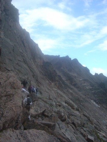 After passing through the keyhole, the trail zig zags up and down the side of the mountain for a while. The elevation loss is annoying as you know you will have to regain it both on the way up and again on the trek out. Eventually you will work you way around to the bottom of the tough. 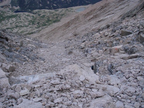 All I have to say about the trough is it sucks. This thing seems to go on forever and the elevation gain is relentless. My buddy must have still been on his adrenaline rush because he beat me to the top by a good 15 minutes. At the top of the trough is the well discussed choke stone you can go on either side of it, on the way up I chose the right side and one the way back down I went left. When dry this stone is a non-issue. At the top of the choke stone you are treated to a view of the narrows I had read mixed opinions on this section. Most said in terms of exposure it was worse than the Sawtooth. My opinion is the opposite; the Sawtooth has it beat hands down.  After completing the narrows we finally arrived at the much anticipated "home stretch". This area also proved to be anticlimactic for me, it was steep but the pictures make it look much worse than it is. The hardest part of this area was waiting for all the people ahead of us to move. 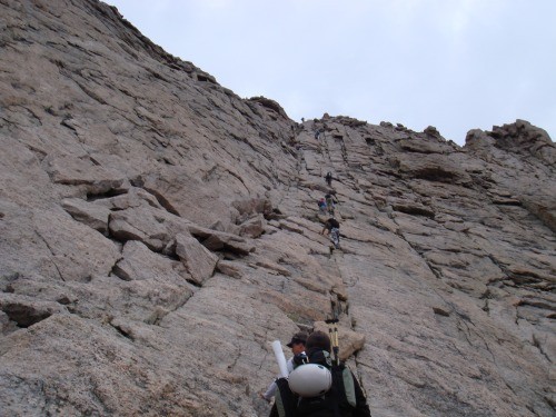 At the top of the Home Stretch you simply "pop" out onto the huge very flat summit. It's a spectacular area with plenty of room to accommodate the hoards of people who we were forced to share the summit with. We ran into one guy who was complaining about a pounding headache and feeling nauseous. We told him that he probably had altitude sickness and he needed to head back down. He paid little attention to us and said he was instead going to take a nap. More than a bit concerned we told his companions about his condition and they simply said "he'll be fine". 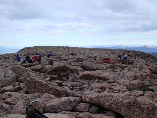 We will never know because at this point it was just beginning to rainsleet so we beat a hasty retreat back down the home stretch. We were slowed only by the queues of people that were forming at the narrows. By the time we reach the choke stone at the top of the trough the rocks were dangerously slick and navigating the slippery rock proved to be the most difficult move on the entire trip. By the time we got back to the Boulder Fields the sleet had stopped and the sun was back out. We took a very leisurely trip back stopping to admire Chasm Lake and all the scenery we had missed on the way up.  Even with our leisurely pace and numerous stops we arrived back at the truck at around 3pm. I am not sure what all those people who took 18 hours to complete this hike did with all that time, but I am glad it didn't take us that long. Despite all the crowds I absolutely loved this hike and I would do it again in a heartbeat. I am sure everyone else feels the same way and that is one of the reasons it's such a popular peak. Thumbnails for uploaded photos (click to open slideshow):
|
| Comments or Questions |
|---|
|
|
Caution: The information contained in this report may not be accurate and should not be the only resource used in preparation for your climb. Failure to have the necessary experience, physical conditioning, supplies or equipment can result in injury or death. 14ers.com and the author(s) of this report provide no warranties, either express or implied, that the information provided is accurate or reliable. By using the information provided, you agree to indemnify and hold harmless 14ers.com and the report author(s) with respect to any claims and demands against them, including any attorney fees and expenses. Please read the 14ers.com Safety and Disclaimer pages for more information.
Please respect private property: 14ers.com supports the rights of private landowners to determine how and by whom their land will be used. In Colorado, it is your responsibility to determine if land is private and to obtain the appropriate permission before entering the property.

