| Report Type | Full |
| Peak(s) |
Pikes Peak - 14,109 feet |
| Date Posted | 06/26/2006 |
| Modified | 10/01/2012 |
| Date Climbed | 06/26/2006 |
| Author | summitbound |
| Pikes Peak-Y Couloir |
|---|
Due to our failed attempt at the Y coulior back in April my climbing buddy LOVENIT and I had been keeping Pikes Peak pretty high on our "to do" list. To make matters worse every day as I drive into work I can see the north face, just sitting there taunting me. If time and weather permitted we had Pikes Peak scheduled for the Monday after we got back from Culebra. We had read in Roaches book that the road up to Pikes Peak did not open until 9am so we did not make much of an attempt to get an early start. As it turns out the road actually opens at 7am. 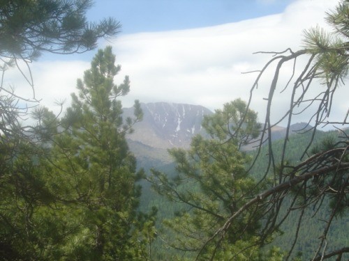 On the drive up to the Devils head parking area, we found a good spot to stop and preview the couloir. The railroad was completely melted out but it looked like the "Y" was still holding snow. Clouds were beginning to collect around the summit but they did not appear to be too threatening so we continued on with our planned ascent. We hefted our packs which seemed much heavier than normal, probably due to the additional gear of helmets, ice axes and crampons. We located Rumdoodle ridge without much problem and began picking our way down the ridge line.  Maybe we were over anxious or just not paying enough attention but as it turns out we did NOT go down the ridge nearly far enough before dropping into the bottomless pit. We had to do some serious route finding in order to secure safe passage, even still, we were forced into numerous class 4 moves. We were lucky to locate this chimney that allowed us escape from a particularly troublesome cliff.  After spending considerable time route finding, back tracking and simply scratching our heads wondering what we'd gotten ourselves into we were able to reach the bottomless pit. Ironically the last section was probably the worst. We had to do some class 4 down climbing in a narrow gully that still had runoff water flowing down the center of it talk about pucker factor. This picture shows the ridge we navigated in order to reach the bottomless pit. If you intend on doing the Y couloir make sure you follow Rumdoodle ridge all the way down before dropping in.  All of the bottom part of the couloir had melted out so we did lots scrambling and boulder hopping. We were easily able to locate the crushed remains of the truck that someone used to commit suicide. There is a very detailed write up somewhere on the web about this incident. 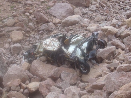 Eventually we were able reach a point in the coulior that still held snow. We broke out our snow gear and began the journey up. The snow was rock hard and we really had to work at making secure footholds and placing our axes. To add to the excitement the weather had really settled in and we were literally climbing in the clouds.  For whatever reason I was a bundle of energy and flew up the coulior like a machine, rather quickly we reached the point where you can take either the left or right branch. The left branch is steeper and harder than the right so we naturally picked the harder one. As you work you way into the much smaller left branch you really start to feel the steepness of the slope. Roach says it exceeds 50 degrees; all I know is that it was Steep.  At the top of the left branch are several pesky rock bands that require some careful climbing, once you are past these its just more scrambling and rock hopping to the top. On our way up LOVENIT found a dollar bill of all things. Sadly the last 100 yards below the summit is littered with junk and garbage.  As we popped out onto the summit we startled two guys from New Jersey who had taken the cog rail to the summit. They insisted on taking pictures with us saying their friends back home would get a kick out of it. It was odd to walk into a restaurant and souvenir shop after such a spectacular climb. We stayed for a little bit chatting with a few folks and then headed back down the Northwest slopes route to our truck, pausing only to take on last picture of the route we had just come up.  Thumbnails for uploaded photos (click to open slideshow): ")
")
")
")
")
")
")
")
")
|
| Comments or Questions |
|---|
|
|
Caution: The information contained in this report may not be accurate and should not be the only resource used in preparation for your climb. Failure to have the necessary experience, physical conditioning, supplies or equipment can result in injury or death. 14ers.com and the author(s) of this report provide no warranties, either express or implied, that the information provided is accurate or reliable. By using the information provided, you agree to indemnify and hold harmless 14ers.com and the report author(s) with respect to any claims and demands against them, including any attorney fees and expenses. Please read the 14ers.com Safety and Disclaimer pages for more information.
Please respect private property: 14ers.com supports the rights of private landowners to determine how and by whom their land will be used. In Colorado, it is your responsibility to determine if land is private and to obtain the appropriate permission before entering the property.

