Download Agreement, Release, and Acknowledgement of Risk:
You (the person requesting this file download) fully understand mountain climbing ("Activity") involves risks and dangers of serious bodily injury, including permanent disability, paralysis, and death ("Risks") and you fully accept and assume all such risks and all responsibility for losses, costs, and damages you incur as a result of your participation in this Activity.
You acknowledge that information in the file you have chosen to download may not be accurate and may contain errors. You agree to assume all risks when using this information and agree to release and discharge 14ers.com, 14ers Inc. and the author(s) of such information (collectively, the "Released Parties").
You hereby discharge the Released Parties from all damages, actions, claims and liabilities of any nature, specifically including, but not limited to, damages, actions, claims and liabilities arising from or related to the negligence of the Released Parties. You further agree to indemnify, hold harmless and defend 14ers.com, 14ers Inc. and each of the other Released Parties from and against any loss, damage, liability and expense, including costs and attorney fees, incurred by 14ers.com, 14ers Inc. or any of the other Released Parties as a result of you using information provided on the 14ers.com or 14ers Inc. websites.
You have read this agreement, fully understand its terms and intend it to be a complete and unconditional release of all liability to the greatest extent allowed by law and agree that if any portion of this agreement is held to be invalid the balance, notwithstanding, shall continue in full force and effect.
By clicking "OK" you agree to these terms. If you DO NOT agree, click "Cancel"...
A day dawned not only absurdly pretty, but with a 0% chance of rain. I was on the trail not a minute after 10 am. Following some ACL rehab, my goal was to hike up to the lake and then consider a route up to 13153 if weather and muscles were in my favor. Turned out they both were, and it was a hell of a day.
In the few times I've been to South Crestone Lake, a few routes up the mountain seem evident. Cliffs guard the north shore of the lake, but a weakness in them leads directly up toward 13153, northeast of the lake. From the lake this appears passable but full of bushwhacking . Another gap in the cliffs leads up toward 12740, to the northwest of the lake, but I did not initially consider this a possible route because it would lead to a traverse on terrain of unknown steepness above the cliffs.
The best-known route is to head east, into an upper basin beneath Adams/13153/13546. From here it is an easy and well-documented hike to the 13153-Adams saddle. Kevin Baker's trip report covers this route pretty well.
The distance of this route, which I had initially considered to be low, in hindsight was deceptively great. The net vertical gain is around 4400', but there were many hundreds and hundreds of extra feet required due to the inefficiency of my route through the treed areas around the lake.
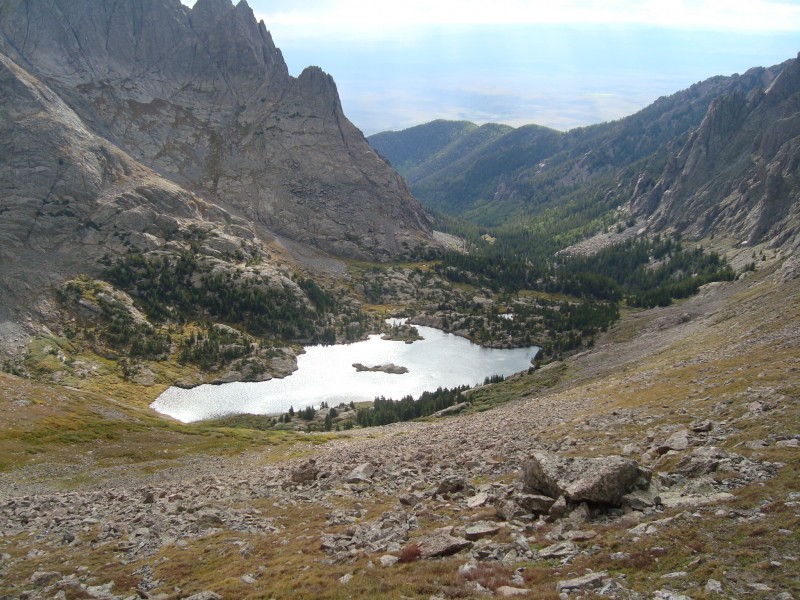
The lake
Since I didn't get on the trail (from the alternate trailhead, around 8750') until 10am, I was from the start anticipating an afternoon summit and evening descent. With my legs uncertain, I resolved to keep a slow pace to the lake. I did pass one person on his way up to camp, but ended up at the lake around 12:45.
After briefly considering the direct route straight to the summit, I gave up that plan and instead committed to the Kevin Baker route. The first issue was the lake itself, as the upper basin is on the exact opposite side from the trail. Looping to the south side lead to a swampy area with just one place to cross the creek without wading through it - a pair of adjacent rocks hidden in willows, almost exactly where the lake meets the creek. Once across, I foolishly tried to stick near the lake, then repeatedly had to abandon this plan and ascend up to 100' on slabs and through trees to make progress around the lake. This part was really tedious, and I forgot to take any pictures.
Above treeline
Moving past the lake, I made yet another mistake in heading up instead of down. After some traversing I eventually ended up down low near the level of the creek feeding out of the upper basin. The next goal was to hike up past a headwall-like formation that guarded this basin. Though imposing from a distance, it turned out to be a rather gentle route through surprisingly solid talus/scree all the way to the right of the headwall.
Just above S Crestone lake, looking back down. 12740 in the background.
Looking up at Mount Adams shows the route past the headwall.
Slightly blurry closeup of 12740.
From near the top of the headwall looking back at the lake
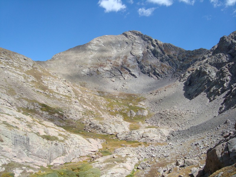
Above the headwall, the remaining terrain becomes visible
Above the headwall, the route up to the 13153-Adams saddle is easily visible. I headed in that direction, again making the mistake of going up instead of down and ending up 100' above the creek and having to descend down some slabs. I didn't care to go the whole way to the saddle, and at this point instead picked a fairly direct route straight up the southern slope of the peak.
Looking straight up at 13153. My actual route went along tundra to the right of this photo.
13153
Naturally the views got steadily better as I ascended.
Another look back at the lake
I couldn't stop taking pictures of 12740
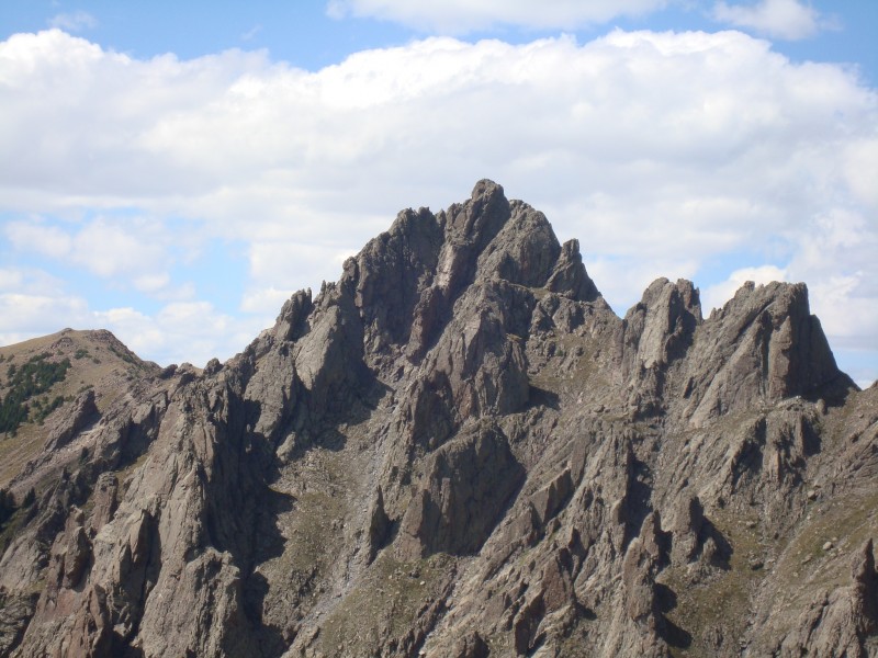
Adams NW ridge. Roach calls this a Class 2+, while Furthermore says it's more like a Class 2. It did not look easy.
Looking up at the north side of 13546.
Somewhere between 12500' and 13000', the comfortable tundra slope turned into a moderately steep field of disturbingly-midsized talus. Progress slowed greatly as I was careful to test every rock lest I roll one down on myself. Perhaps continuing to the saddle could have avoided this section. Not too long after though, I topped out at (supposedly) 13153 feet elevation and around 3:45 PM. Almost 6 hours to net 4400 feet vertically is a far shot from my pre-injury standards, but I consoled myself with a reminder that I was intentionally taking it slowly.
The summit is officially listed at 13153' (based on old, old surveys) and topographic maps show contour lines that match this. Nonetheless my GPS showed an elevation of 13350 feet above sea level. Go figure.
Looking west along the ridge.
Various fourteeners popped into view.
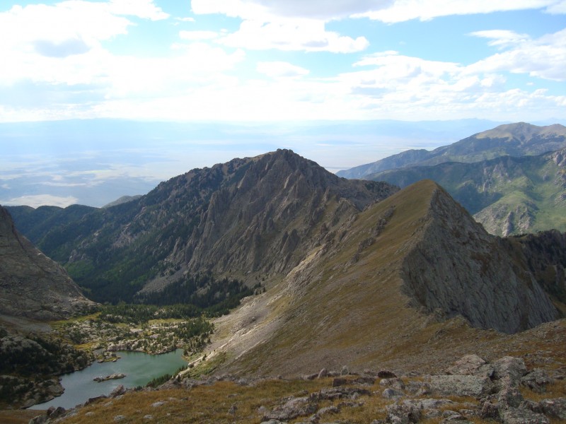
Adams seen from the summit
The summit register was in good shape, but the paper inside was neither the correct color nor the correct number of colors. It appeared to have about two signatures per year, including many of the expected names. The only ascent I could see from 2012, by a fellow whose name I forget, had a nice little paragraph about how awesome this peak was. It made me stop and look around some more.
I signed it with an appropriate RIP for Rob Jansen and Chris Gray, which put me in mind of my climb of Crestone Needle shortly after Spencer Swanger's death. This, along with the cloud that covered the sun right around the same time, made the day seem a little darker.
Fluted Peak and North Crestone Lake were absurdly pretty
Looking north, Comanche Peak (right) and Rito Alto Peak (center) were the most prominent
Descent
Originally I had several contingency routes, either headed up Adams NW ridge or across to the Adams-13546 saddle. Mount Adams lends itself to a number of loop hikes, of which I think Willow Lake -> 13546 -> 13580 -> Adams -> 13153 -> South Crestone Lake would be the best (though long). From camp at South Crestone Lake, this could be done almost equally well. Obviously I was not planning an overly long day on this trip, but I always try to have backup plans in case things go really well.
However as it was now after 4PM, I figured I'd better cut my day short. Between the newly-arrived cloud (which departed soon after) and my desire not to descend the way I came up, I decided to head directly down toward the lake. Initially I took the path of least resistance, down the western ridge, but as I descended I came across a pretty solid trail just below the ridgeline. Wondering where it lead, I ended up following it all the way to the saddle (with the intermediate, unranked peak) where I lost it.
Even more absurdly pretty: South Crestone Lake
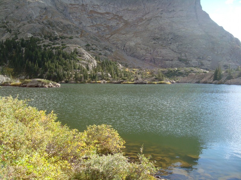
South Crestone Lake closeup
Another ridge shot
View of the North Crestone basin
From here I had to cut back to my left (west) a bit as I descended toward the known gap in the cliffs above the lake. Had I researched it a bit better however, I think traversing across the ridge to just below 12740 would be an easier and far more scenic route, which would avoid all bushwhacking as the trail just before the lake sticks out above treeline. Though I could see that this traverse would be easy, I didn't know how to get down past the cliffs in that area.
Being far from a direct line, this descent was inefficient. However it was extremely scenic, so overall it was a good tradeoff. Looking at the lake all the way down, with the northern ridge of 13546 and the ever-imposing 12740 in the background, was almost too distracting.
From the willows visible on the slope, it is a straight shot down to the lake. Left and right have cliffs. I avoided the scre
Yet another ridge shot - this one shows an easy traverse across to 12740
I want to take a moment to put in a good word for Point 12740. Although I know it's a class 5.0 peak and one of the few technical peaks in the area, I had never really given it much thought before. But from certain angles (only partially captured in the pictures here) it was really, really impressive.
One last shot of 12740
As I came into the upper portion of the trees, bushwhacking was again required. Descending through these plants was slow, but at least it was all downhill this time unlike my up-and-down circling of the lake on the way up. The tedium was interrupted by a couple of deer who were themselves interrupted by my presence.
Deer around the lake (there were two in this group)
Once down by the lake, it was actually a very easy route around to get back to the trail. From where the trail meets the lake, this area doesn't appear easily passable but in fact I think it would be considerably better to navigate around the lake on the north side than on the south. I also believe there are several camping spots over here that are a bit more secluded than the obvious ones right by the end of the trail.
Looking south across the lake
I had really taken my time on the way down (including a 30-minute nap by the lake at the end), and by the time I was back on the trail proper it was well after 6PM. I made pretty respectable time back to the trailhead, getting in just a bit after dark.
SLV near dusk
Approximate route
Thumbnails for uploaded photos (click to open slideshow):
Great report, jdorje, really enjoyed the text and esp the pics. I was in that basin weekend before last and attempted Pt. 12,740. We succeeded on the map's highpoint of 12,737 (also 5th class in our opinion, although an easier line may exist), but were thwarted getting to 12,740 from the north; looked 5.7> at least and we were short on rope and gear. We return this weekend to go after it via the more popular east ridge. Anyway, I fully agree, Pt. 12,740 is a very cool peak!
-Tom
jdorje--
from some of your comments in the forum, I think you must live on the western side of the Sangres, maybe in Crestone. I live on the eastern side of the Sangres, in Silver Cliff. in addition to climbing, I enjoy fishing. I have fished most of the high lakes on the eastern side of the Sangres. your photos make me want to visit North and South Crestone Lakes real soon. Beautiful!
Caution: The information contained in this report may not be accurate and should not be the only resource used in preparation for your climb. Failure to have the necessary experience, physical conditioning, supplies or equipment can result in injury or death. 14ers.com and the author(s) of this report provide no warranties, either express or implied, that the information provided is accurate or reliable. By using the information provided, you agree to indemnify and hold harmless 14ers.com and the report author(s) with respect to any claims and demands against them, including any attorney fees and expenses. Please read the 14ers.com Safety and Disclaimer pages for more information.
Please respect private property: 14ers.com supports the rights of private landowners to determine how and by whom their land will be used. In Colorado, it is your responsibility to determine if land is private and to obtain the appropriate permission before entering the property.


 Just above S Crestone lake, looking back down. 12740 in the background.")
 Looking up at Mount Adams shows the route past the headwall.")
 Slightly blurry closeup of 12740.")
 From near the top of the headwall looking back at the lake")
 Above the headwall, the remaining terrain becomes visible")
 Looking straight up at 13153. My actual route went along tundra to the right of this photo.")
 Another look back at the lake")
 I couldn't stop taking pictures of 12740")
 Adams NW ridge. Roach calls this a Class 2+, while Furthermore says it's more like a Class 2. It did not look easy.")
 Looking up at the north side of 13546.")
 Looking west along the ridge.")
 Various fourteeners popped into view.")
 Adams seen from the summit")
 Fluted Peak and North Crestone Lake were absurdly pretty")
 Looking north, Comanche Peak (right) and Rito Alto Peak (center) were the most prominent")
 Even more absurdly pretty: South Crestone Lake")
 South Crestone Lake closeup")
 Another ridge shot")
 View of the North Crestone basin")
 From the willows visible on the slope, it is a straight shot down to the lake. Left and right have cliffs. I avoided the scre")
 Yet another ridge shot - this one shows an easy traverse across to 12740")
 One last shot of 12740")
 Deer around the lake (there were two in this group)")
 Looking south across the lake")
 SLV near dusk")
 Approximate route")