| Report Type | Full |
| Peak(s) |
Knife Point - 13,270 feet Jagged Pass - 13020 Twin Thumbs Pass - 13040 |
| Date Posted | 08/21/2012 |
| Modified | 07/09/2014 |
| Date Climbed | 08/21/2012 |
| Author | Kent McLemore |
| Razorbacks Loose in Noname - Knife Point and Pass Bagging |
|---|
 Day 1 - After a fortifying breakfast at Durango Diner, we caught "the 9:30" to Needleton. Hopes of making it to the meadows of Noname that day were soon dashed when our train was delayed due to overheated bearings on "the 8:30," just up the tracks. Then not ten minutes into the hike, I confidently led us up the Ruby Creek Trail for 30 minutes and 800' before I realized we weren't climbing Watertank Hill on the way to the Noname Trail. All the way back down to the meadow near Needleton we went, practically starting over. Mark took the mishap in stride, though he had just arrived from Arkansas and was really feeling the altitude. The Animas River Trail requires patience. It is faint and braided in places. But it's there the whole way. We did not reach Noname Creek until nearly 6:00 p.m. There we met KTC88 and malcolml1, just down from a successful climb of Jagged Peak. Malcolm is 74 years old. They did not use a rope. We retreated to where the large ceramic insulator lays near the trail to make camp. Day2 - We began the climb up Noname Creek under clear skies. The trail is strong, well-marked in places that might otherwise be ambiguous, and very steep. From the Animas it gains 2300' in three miles through magnificent stands of pine and the biggest aspen I've ever seen. Buoyed by views we knew to be imminent, we made good time and reached Jagged Cabin midday. To the north, The Heisspitz, the south The Index and Peak Thirteen. Up the valley towered Gray Needle, Peak Ten, Knife Point and Sunlight Peak. These soaring walls and rugged ridges would be our silent companions for the rest of the trip. Through one more exceptionally steep ledge of forest we climbed to Noname's next higher meadow. Near its eastern end, just south of Noname Creek, we settled at a site centrally located for our explorations. At 11,040' near the confluence of the Jagged Pass and Knife Point tributaries.  Day 3 - Low, dark clouds. Rain. No climbing today, but while Mark continued to acclimate and recover from my 800' error the day before, I explored the approach to Knife Point. Looking for the easiest route to the base of the lower gully, one which we might follow via headlamp the next morning, I hiked up the east side of the creek that drains Knife Point and Needle Ridge. Travel was easy through the forest then I hit a mess of willows. I followed their edge down to the creek then angled back up the east slope of the drainage toward the lower gully. Again, more willows. I bashed through one thicket after another, getting a full dousing every time I lowered my head to break through. 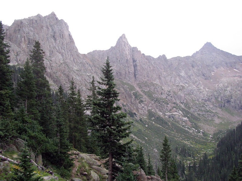 I reached the gully 200 yards above the creek and climbed to near the lower rock bands below the grassy slopes. Gazing above, it looked steep and challenging but within my comfort zone. Looking across the drainage below, I saw what appeared to be an easier route from camp to the gully: the west side of the creek. Stay climber's right of Noname Creek from the confluence with the Jagged Pass tributary to just across from Knife Point's access gully. First through forest, then above (west of) a swath of willows. When I returned from my reconnoiter, Mark was visiting with legendary mountain man and ranked 13er finisher Steve Gladbach. He and Dancesatmoonrise had just climbed Sunlight Spire, backpacked over Twin Thumbs Pass and were aiming for Gray Needle the following day. Check out Danceswithmoonrise's amazing TR of some serious climbing in a very remote setting. They were camped farther down the valley. Besides Mark, Steve would be the only person I would see in five days and nights at high camp. Meeting Steve was a highlight of the trip. Day 4 - Frozen dew crackled as I threw open the rainfly at 5:00 a.m. It would also cover every log, rock and boulder between camp and the lower gully. So we delayed our start to let things thaw. After temps rose, and well after sun up, we set out from camp through the woods on the creek's west side, climbed just high enough to clear the willows, then back down to the creek bed through a lush, flower-filled meadow to the base of the lower gully. We scampered up to rock bands that involve some fun Class 3 scrambling and route finding. We generally worked our way up and south (climber's right) through the rock bands to the grassy slopes below the face.  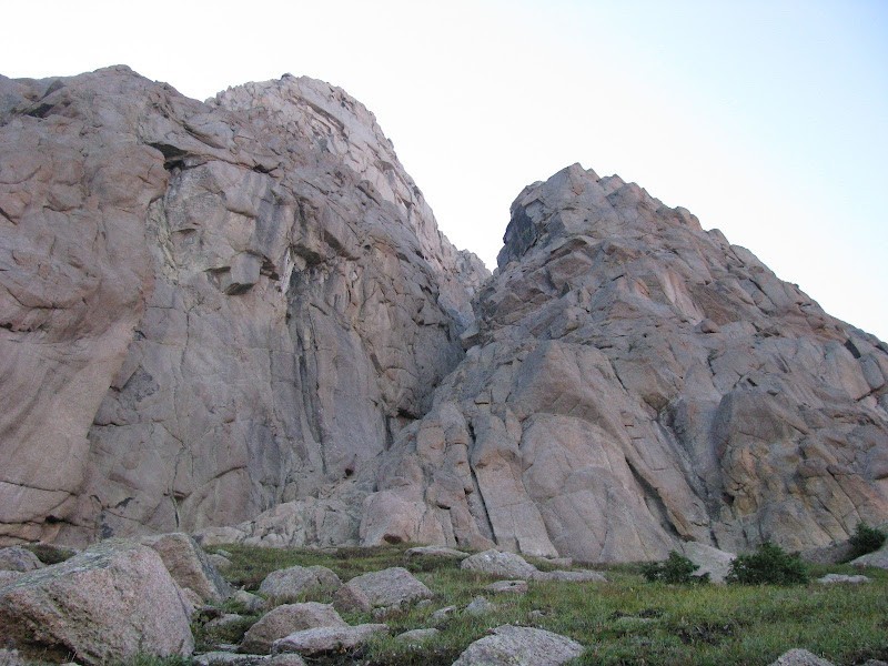 We crossed directly under Knife Point's gash, and its 900' face, staying on the grass near the face for as long as possible. From there, several dirt and loose rock gullies reach the saddle between Knife Point and Peak Ten. We opted to stay on rock where possible, though it too was very loose.  We were eventually forced into the upper gullies for the last few hundred feet to the saddle. We went back and forth between them searching for solid footing. They are all loose and very steep, though it appeared they'd all go. Finally, from the saddle we spied views of Sunlight Basin, Jagged and directly across from us, Peak Ten's wild, spire-studded west ridge.  After a short break, we worked south from the saddle around to the southeast slopes that lead to the summit. I rate the short east facing section following the saddle "Class 2-scary": moderately steep, granule-covered hard pan perched directly above cliffs that drop many feet below to Sunlight Basin. The view provided a pleasant distraction, however.  Mark found level ground below an outcrop and elected to wait while I went on. Moving around to the south, the slope mellows and the kitty litter gives way to clean summit blocks. The summit arrived abruptly revealing a peak-packed panorama. Clockwise I took in Jagged, Ten, the Grenadiers, Six, Five, The Index, Thirteen, Monitor, Eleven, Needle Ridge, Sunlight, Sunlight Basin and down to the Vallecito.  The sky was clear, the air warm, winds calm. I had a snack, snapped some photos and felt thoroughly gratified. The descent was fun as we wandered back and forth finding one cool photo-op after another. 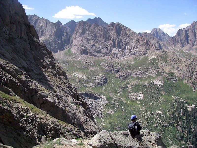 Day 5 - Our designs for Leviathian didn't look good as the day broke overcast and drizzly. We set off anyway up the Jagged Pass Trail which begins with yet another steep stretch through yet another beautiful, thick stand of evergreens. The trail stays closer to the creek here and the sights are pleasing to the eye. We took a break where the trail levels off at the top of a set of falls which drop through a rock-lined slot. 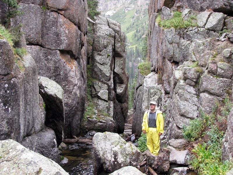 We reached the marsh at 11,800', bore left (north) and crossed a couple of minor talus fields. Up to the lake at 12,200', we again bore left. Past the lake we stayed in or near the creek bed with easy boulder-hopping mixed with loose, steep scrambling. 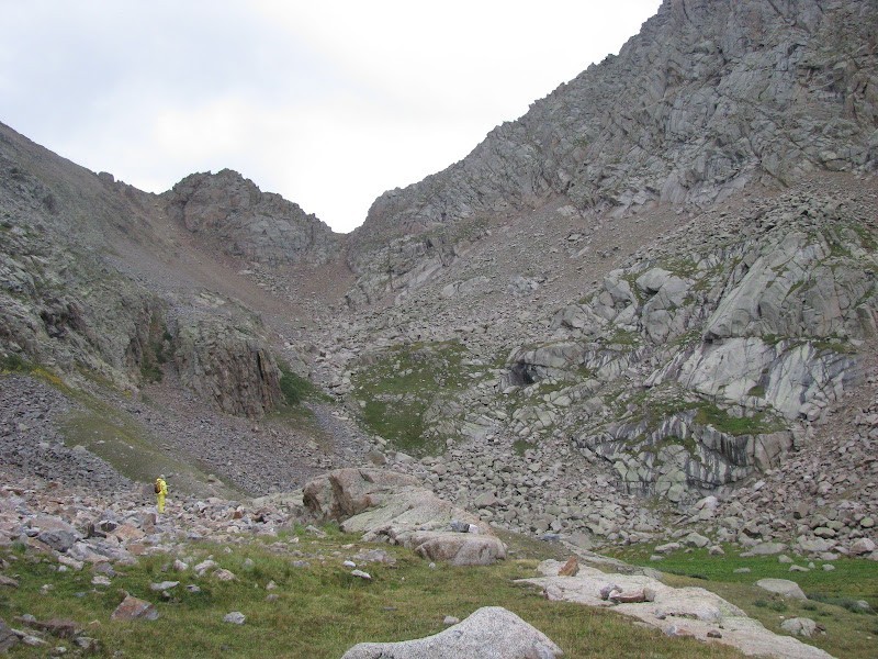  In light rain we reached the saddle and took in the imposing views of Jagged Peak.  Late, dark and rainy, Leviathan was still too far away to climb. Feeling good though, and with time on our hands we descended the opposite (south) side of the drainage and wrapped around into the gorge between Gray Needle and Peak Ten. To be sure, this is a remote, lonely, beautiful place.   Like carefree kids, we wandered back and forth and all around exploring this place of sublime beauty.  Descending, we stayed high above the creek on the south side of the valley, then dropped back to the lake.  We picked our way down through the woods, again on the south side of the valley, not rejoining the main trail until the very west end of the marsh. Remaining high up the slope while descending the south side of the drainage was far more interesting than the climb up the standard north-side route. Day 6 - The sky was foreboding as we set out for Twin Thumbs Pass, but the clouds soon scattered and we had periods of clear skies early.  From camp we descended to the lower meadow to where Twin Thumbs Pass Trail meets Noname Creek. The lower section of trail leads up the east side of the drainage, but we lost it frequently and did a fair bit of willow bashing before breaking out at gorgeous Lake 11,754.  At 12,000' Mark got out of the drizzle and waited with a mountain goat while I went on up to the pass. It was a steep scramble up a mix of small boulders and dirt, sometimes wet-packed and crusty, sometimes loose, to the final steep chutes that reach the saddle. As soon as I peered over the saddle to Twin Lakes and Chicago Basin it began to sleet. Clouds moved in well below me to the south.  I hiked southwest from the saddle looking for the route round Glacier Point to Eolus but didn't make it far when I heard a thunder clap. As I started my butt-slide down one of the chutes off the pass, Mark's mountain goat friend appeared directly below me. We had a brief stare down before he got bored and disappeared. I rejoined Mark and in continuing the theme, descended the side of the valley opposite of which we'd climbed. In this case, we explored the west slopes of the drainage, navigating the steep grass slopes and rock bands under the soaring walls of Monitor and Peak Thirteen.  We were soon back at Lake 11,754, taking in an incredible display of ever changing light as the surrounding peaks appeared and disappeared among the clouds.    Day 7 - Departure day. The sun broke through early providing fog-framed views of Knife Point. 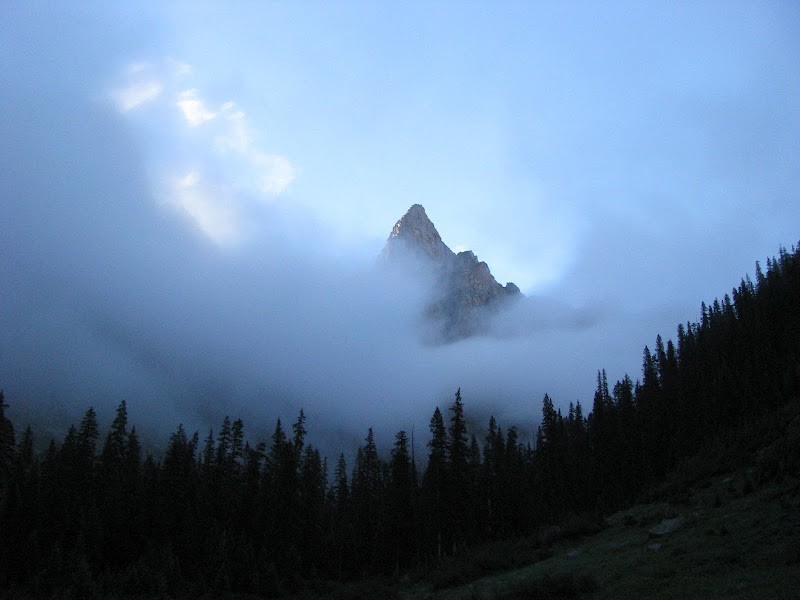 We dispersed camp and hiked out tired, wet and very, very content. Before the last descent into the Animas Valley we bid so long to our worthy companions.  We returned to Needleton, laid out clothes and gear to dry, and waited for a train carrying cold beer. Notes: - Between the Animas River and Jagged Cabin level ground is scarce and water is far below the trail. - The Weminuche lived up to its soggy reputation -rain, dew, mist, frost. By day 3 we were soaked through and through. If it left our tents, it was soaked. But we happily pulled on our cold, wet boots every morning to check out a new corner of the basin. - Thanks to Mark L. for patiently following me around out there. A great companion in the mountains. I would not have done this solo. - Thanks to Barry Raven and Presto for sharing their knowledge of the area. Barry also suggested the Grand Traverse Peak tune up for the kids and I. - If I've misidentified any peaks, ridges or basins, let me know. - This is my first trip report. If anyone has suggestions or comments, let me know. - Thanks! 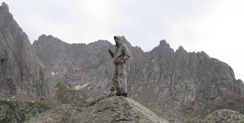  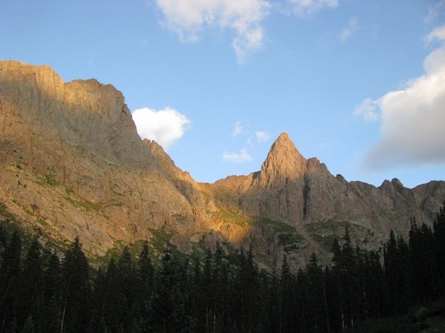 Thumbnails for uploaded photos (click to open slideshow):  Noname Basin Peaks in silhouette: Gray Needle, Peak Ten, Knife Point, Sunlight Peak, Needle Ridge")
 Front door view for 5 days.")
 From Jagged Pass Trail, east slope approach to Knife Point thick with willows.")
 North from Knife Point's grassy slopes - Peak Ten's western ramparts.")
 Knife Point's giant gash.")
 Avoiding the upper gullies. Everything was loose.")
 From the saddle, Ten with Jagged in the distance.")
 From Knife Point's SE slope. Sunlight Basin and the Vallecito beyond.")
 NW from Knife Point's summit. Arrow, Vestal, the Trinities in the distance. Five and Four in the middle. Ten's wild w")
")
")
 East to Jagged Pass.")
 Midway up Jagged Pass Trail.")
 Mighty Jagged Peak from Jagged Pass.")
 Draw between Gray Needle and Peak Ten. Wish I'd taken more photos up here.")
 Peak Ten's broken north face.")
 From near the base of Gray Needle.")
")
")
 Lake 11,754 south to Twin Thumbs Pass.")
 Twin Lakes, Chicago Basin and low clouds from Twin Thumbs Pass.")
 Up high on the west slope of the Twin Thumbs drainage.")
 Lake 11,754.")
")
 Lower section of Twin Thumbs Pass valley. Coming up, we hiked over the cliffs on the right (east). Going down, we bore west.")
 Knife Point takes a curtain call.")
")
")
")
")
|
| Comments or Questions | |||||||||
|---|---|---|---|---|---|---|---|---|---|
|
Caution: The information contained in this report may not be accurate and should not be the only resource used in preparation for your climb. Failure to have the necessary experience, physical conditioning, supplies or equipment can result in injury or death. 14ers.com and the author(s) of this report provide no warranties, either express or implied, that the information provided is accurate or reliable. By using the information provided, you agree to indemnify and hold harmless 14ers.com and the report author(s) with respect to any claims and demands against them, including any attorney fees and expenses. Please read the 14ers.com Safety and Disclaimer pages for more information.
Please respect private property: 14ers.com supports the rights of private landowners to determine how and by whom their land will be used. In Colorado, it is your responsibility to determine if land is private and to obtain the appropriate permission before entering the property.


