Download Agreement, Release, and Acknowledgement of Risk:
You (the person requesting this file download) fully understand mountain climbing ("Activity") involves risks and dangers of serious bodily injury, including permanent disability, paralysis, and death ("Risks") and you fully accept and assume all such risks and all responsibility for losses, costs, and damages you incur as a result of your participation in this Activity.
You acknowledge that information in the file you have chosen to download may not be accurate and may contain errors. You agree to assume all risks when using this information and agree to release and discharge 14ers.com, 14ers Inc. and the author(s) of such information (collectively, the "Released Parties").
You hereby discharge the Released Parties from all damages, actions, claims and liabilities of any nature, specifically including, but not limited to, damages, actions, claims and liabilities arising from or related to the negligence of the Released Parties. You further agree to indemnify, hold harmless and defend 14ers.com, 14ers Inc. and each of the other Released Parties from and against any loss, damage, liability and expense, including costs and attorney fees, incurred by 14ers.com, 14ers Inc. or any of the other Released Parties as a result of you using information provided on the 14ers.com or 14ers Inc. websites.
You have read this agreement, fully understand its terms and intend it to be a complete and unconditional release of all liability to the greatest extent allowed by law and agree that if any portion of this agreement is held to be invalid the balance, notwithstanding, shall continue in full force and effect.
By clicking "OK" you agree to these terms. If you DO NOT agree, click "Cancel"...
There is no other way to begin this report: Mt. Williamson is enormous. Rising to 14,375' but with a trailhead elevation of 6,299', a trip up Williamson's easiest route requires 11 miles and ~7,000' elevation gain (and loss) to even get to the top of Shepherd's Pass, and then the fun's only begun. The full route, car to car, requires 30 miles and ~10,500' of elevation work.
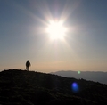
Williamson from the valley. Only 9,000' to go.
The good news is that the trail to Shepherd's Pass is idiot simple to follow; the bad news is that the route beyond Shepherd's Pass, when you're nice and fatigued, requires crossing the Williamson Bowl, a glacially-carved formation seemingly designed to frustrate easy passage. The crossing involves a tedious two-mile route-finding affair along ledges, through rolling terrain that threads over talus, past lakes, and along rocky ridges just to get to the base of the long 2,000' gully that leads to Mt. Williamson's summit. Strike that. The gully leads to a 100' California Class 3 (Colorado Class 4) chimney that leads to a sub-summit plateau that then requires an additional 200' of talus scrambling to get to Williamson's summit. Emphasizing the infrequency of Williamson summits, the summit log includes entries dating back to 2003. To top all that off, the route descriptions are vague and elusive. Welcome to California!
Failure and Preparation.
This 2012 venture was borne out of a failed bid last year in which John and I attempted to day-trip Williamson. Suffice to say, it was an ill-advised game plan. We were forced to turn around approximately 400' from the summit (nevertheless logging ~29 miles, 10,000' of elevation, and 22.5 hours on our feet). This year we felt a pack-in was in order. Our third member, Nolan, agreed. Bear in mind, Nolan has heard"and been a good sport about listening to"us kvetch about Williamson for the past year. Somehow, this made him want in. And so a plan formed. As preparation, John flew to Colorado the previous weekend for an acclimatization immersion program: we went from sea level to Meeker and back. Mission accomplished, limits determined. It was time to return to Williamson.
Williamson is big.
Trailhead.
The trailhead is slightly confusing to get to, and this report will not offer much clarification. From the town of Independence, turn west off of Highway 395 onto Market St./Onion Valley Road. After 4.4 miles, turn south (left) onto Foothill Road. The rest of the way is dirt, but any car should be able to make it. Generally speaking, continue on Foothill Road for around 3.2 miles. There will be several forks in the road along the way. Veer right on them except do not do a full right turn until you see the sign for "Shepherd Pass Trailhead," after around 3.2 more miles. There is an opportunity before this to turn right where there is something of a grass triangle carved out in the middle of the intersection; do not turn here. Once you turn right at the sign, drive around 1.4 miles to the kiosked trailhead. There is a toilet at the TH.
Here We Go.
While acknowledging that the drought is no good for anyone, we nonetheless took cheer in knowing we would not have to contend with the after effects of a massive snow year, which last summer had required wading across early stream crossings and hauling along snow tools.
Let me back up. The approach to Williamson, via Shepherd's Pass, is long, arduous, and has an infuriating"but necessary"elevation loss. A lot of it. After the first mile on an easy trail with zip for elevation gain, you get to the first of four stream crossings over Symmes Creek. Last year, this required removing shoes (in the dark of night) and wading across, sometimes up to your knees. This year, we brought sandals ... but were mildly disappointed to discover the crossings only required easy rock-hopping. Things were looking up! "Up" as in once past the stream crossings you ascend ~2,000' via 54 switchbacks to the top of the Symmes Creek Saddle. These do not go fast, but we made the most of it by seeing a sooty grouse on the way up and a scorpion on the way out. At the saddle, Williamson towers over the landscape to the south. Take heart: it is at least as far away as it looks.
Williamson on the approach. A long way off.
From here, you descend over 500' on sandy trail. If you are lucky, there is a stream crossing at the bottom before you re-claim that lost elevation (and more) en route to Mahogany Flats. A note about water: after the Symmes Creek crossings, the next water source is the above-mentioned stream at the bottom of the sandy descent. After that, the next reliable water source is at Anvil Camp, two miles from Mahogany Flats.
After eight miles, we arrived at Anvil Camp and took an extended breather, including icing our feet in the stream and eating lunch. Anvil provides the last of what minimal shade this entire route offers.
We decided to continue up over Shepherd's Pass and make camp at 12,000', despite the fact we would be exposed to the elements in every way. The route from Anvil Camp to Shepherd's Pass requires snaking through numerous rock moraines (thankfully, on trails, lest this hike add another degree of aggravation) and then ascending the steep ~600' up Shepherd's Pass.
Approaching the moraines.
Looking up Shepherd's Pass.
Nolan and John ascending Shepherd's Pass.
Last year, snow covered most of the pass, so I had been able to toss on crampons and cruise up. This year, knowing conditions were dry as Death Valley, we left the winter gear at home.
Tyndall.
Getting our a-- over the pass was a relief. After setting up camp and resting briefly, we made an ill-considered decision to "run up" Mt. Tyndall (14,029'), Williamson's neighbor to the north.
First view of Tyndall, taken from our campsite. Our route, roughly, took us first up the obvious spine. The rib on the NE f
The description we had suggested an easy talus-hop and a 2.5 hour roundtrip. Do not trust California mountain route descriptions. We took this to mean going up the obvious spine in the above picture and then transitioning to the gully to the spine's right. Most of our ascent involved talus-hopping on tippy rock, which transitioned into class 3-4 scrambling on tippy rock not dissimilar to Sunlight's summit block. Except tippier.
Garbage on Tyndall.
Clearly, we erred.
F---ing up Tyndall's route.
After struggling to within 200' of the summit, most likely by the least-advised route possible, we realized there was no way to make the summit and not be descending uncertain terrain in the dark. After already logging nearly 8,000' and over 12 miles, this seemed unwise. We turned around, and the cursing began. Luckily, the moon was a spotlight beacon in the night that guided us, exhausted, back to camp. Without energy to even eat, we collapsed in the tent. Williamson suddenly was less than certain.
Williamson.
We woke the next day, John particularly a bundle of positive energy. Our mantra became "Williamson: it's not that bad!" This was repeated, ad nauseam, as we clambered over boulders and up cliff bands. It was a useful, upbeat reminder. I was in a foul mood from missing Tyndall, despite my stunning surroundings and the relative certainly that Williamson"which had gnawed at me and downright haunted John since last year"was well within our grasp.
From our failed attempt, we recalled valuable information on where NOT to go. After you follow the dusty plateau and Williamson's intimidating north face comes into view, find a lightly-worn path slightly to the east and follow it as it drops 300' into Willy's bowl. From there, find the obvious ridge that apparently snakes through the bowl, above the high alpine lakes.
Descending into Williamson's bowl. You can see the ridge snaking through. Williamson is out of frame, to the left.
Tyndall towers over the bowl.
There are plenty of cairns that will get you at least halfway. At the halfway point, you will find yourself at the top of several cliff bands. There are easy and hard ways down. Generally speaking, the easiest are on the right (west) side.
Overlooking the cliff bands, taken on the way out and oriented the same (north). Go left on the way out (stay right on the w
Do not be fooled by the bowl. It is tedious, goes on for awhile, and requires attention. Your ultimate goal is the black stain waaaay yonder on Williamson's lower west face. This stain marks the beginning of the gully that allows the one "easy" weakness to Williamson's upper reaches. The gully you see from the bowl's beginning is not the gully you ascend. The stain is well below the flying buttresses, aretes, and rock spires that lord over this place. I am not sure I can emphasize enough how large this mountain is or the physicality a summit bid requires.
Here is a you-just-won-the-lottery hint: under no circumstances should you attempt to shortcut your way up to the black stain by approaching it from the slope on the left. You will encounter the worst scree slope you can imagine. If Challenger and Pigeon/Turret had a bastard child that took steroids and did meth, that scree slope still would be an understudy in a baby carriage suckling on a pacifier by comparison.
Instead, follow the route of least resistance all the way through the bowl until you are directly beneath the black stain. From here, you have options: you either can directly ascend the black stain (solid class 3 cliff bands) or you can pick your way up an obvious ramp just to the right of the black stain (class 2/2+ talus slope).
Correct: directly below the black stain.
Past the black stain, you are in for a treat: you are still a good 1,500' from the summit, and a good 1,100' chunk of that involves picking your way up this long gully, either by crisscrossing on vague use trails or scampering up rock slabs on the sides, to preference. A helmet is advisable, but not required.
Looking down the (irritatingly) long gully.
Continue up this gully, but be sure to turn around and take in Tyndall's impressive, sheer east face. This provoked further grumbling from me.
Tyndall and the Williamson bowl. Taken from halfway up the gully.
As you reach the top of the gully, note a sheer rock wall on the gully's right (south) side, which is fronted by a broken rock face directly in ahead of you.
Rocky outcrop right before the chimney.
You certainly can go past this broken face (to its left) and take in the view on the other side of the mountain, but it is this rock wall that tells you the class 3-4 chimney is near. Indeed, look immediately right, and you will discover Williamson's intimidating-looking "weakness" stretching vertically above you.
The Chimney.
I will leave it to you to decide your comfort level, but let me say that the chimney was alarming to take in from afar, but much more comfortable within. There are obvious "safety" platforms and the holds are solid, although attention must be paid. Several route descriptions suggest bringing a rope, and we saw some webbing; however, we neither had nor felt we needed a rope.
At the top, autopilot took over, and we shortly were on the summit, my first 14er of 2012. The view was impressive. Mt. Whitney, Mt. Russell, Mt. Muir, and Mt. Langley were obvious to the south.
Williamson's summit. Whitney and Langley in the distance.
Tyndall and the Palisades extended welcoming views to the north.
Summit cairn and tiny Tyndall.
Williamson's puny eastern sub-summit.
However, our day was less than half over, and memories of the long trek out last year weighed on me. And, as any good hiking partners should do, we impressed these horrors on Nolan, who had been spared last year's summit-less trudge out.
After a brief snack, we made our way back to the chimney, which proved much easier descending than expected.
Nolan descending the chimney. "It's easy!"
Descending the chimney.
We all picked our own path down the gully.
Descending the gully.
John needled me for moving the fastest I'd moved all day: "Joe, you must really want to be done with this gully." True.
The return voyage through the Williamson Bowl went quickly, buoyed by the thought that we never again would have to cross it.
The Great Escape: leaving the Williamson Bowl.
The last 300' climb out of the bowl was a step-by-step endeavor, but soon we were once again facing the top of Shepherd's Pass and a brief respite.
Alpine Icing.
Descending Shepherd's Pass.
We were not looking forward to this descent with heavy packs, but it proved a non-issue. We were down before we knew it. From there it was simply a matter of putting one foot in front of the other for the next five hours until we reached the car.
Sunset on Williamson.
We did our best to ignore the 500'+ re-ascent, enjoyed a hearty laugh at the top of the Symmes Creek Saddle comparing how much easier (relatively speaking) this re-ascent had been compared to last year's, and then made it back to the car at the semi-reasonable time of 10 p.m., exhausted but successful.
A scorpion John spotted on the trail in the dark on the way out.
With Williamson summited, we felt we could miss everything else and still call the rest of the trip a success. Including this brilliant idea:
Nevertheless, over the next five days, we found time for successful trips up Mt. Langley, Mt. Whitney, Keeler Needle, and Mt. Muir. Perhaps there will be a trip report...
Thanks for reading!
Thumbnails for uploaded photos (click to open slideshow):
a few things:
1.) awesome write up. It really captures our experience on that mountain - without the profanity
2.) I had a dream that I left my sister on the summit last night and had to re-climb that gully - I was not happy.
3.) Thanks for coming out and properly climbing this guy after last year's failed bid. I'm really pumped you remade the trip out.
4.) Never again - except for Tyndall...
Really great report, Joe. I won't soon forget that trip.
ChrisinAZ: the chimney on Williamson is comparable to a 100ft version of the chimney on N. Maroon, albeit on solid granite instead of smooth sedimentary rock.
Congrats on a GIANT undertaking! 8/12/2012 10:45pm
Geez, Joe, if this is your 1st 14er of the year, I have to say it can only get easier from here! :wink:
Huge kudos on the persistence it took to get this summit.
No more sniveling about LB's SW ridge, huh?
Congrats, all! :D
Nice write up, impressive scenery. I'll stay tuned for more CA beta.
This was a heck of a mountain. Highly recommended for masochists, fools, and solitude lovers. This mountain weighed on us for a year; it was nice to rest atop Williamson.
nedryarson, dmccool - It feels every mile and elevation foot of it.
ChrisinAZ - Nolan's right; a 100' version of the North Maroon chimney would be comparable. As would be a more constricted, extended climb of the crux chimney on the El Diente-Wilson traverse.
John - What can I say? I'm a sucker. I've had similar dreams, but nonetheless I am looking forward to day-tripping Tyndall. Revenge redux.
Nolan - "That's easy!" :roll: Glad you decided Williamson was up your alley!
nyker - Fabulous rock and vistas. Unfortunately, most of what we saw/used was rubble!
Nancy - It did only get easier from Williamson. This one required repeatedly running into that proverbial brick wall.
d_baker, FireOnTheMountain - Thanks. It's a fantastic area and range.
Thanks for posting the best site I have found on summitting Mt. Williamson. Congrats on the accomplishment. I see that you came close to day-tripping Williamson the year before. I am considering trying it as a day trip, with maybe a midnight starting time. Possible? Thanks again for the great report.
Great post! I'm looking to summit Williamson and Tyndall in August of 2020 as a day (albeit long day) hike. Any advice on why your first attempt as a day hike failed? Thanks!
Your camp at 12,000 feet up at the Pass... was there a lake/water source up there? I have seen some pics of a great campsite up there PAST THE PASS on the left, with a similar view of Tyndall as what you posted. I'm thinking this might be where you camped. Thanks for any info!
@glodder - Theres a small lake up there just beyond the pass. You can tuck in a little, and it has great views of Tyndall. Pretty exposed if theres wind or a storm.
Caution: The information contained in this report may not be accurate and should not be the only resource used in preparation for your climb. Failure to have the necessary experience, physical conditioning, supplies or equipment can result in injury or death. 14ers.com and the author(s) of this report provide no warranties, either express or implied, that the information provided is accurate or reliable. By using the information provided, you agree to indemnify and hold harmless 14ers.com and the report author(s) with respect to any claims and demands against them, including any attorney fees and expenses. Please read the 14ers.com Safety and Disclaimer pages for more information.
Please respect private property: 14ers.com supports the rights of private landowners to determine how and by whom their land will be used. In Colorado, it is your responsibility to determine if land is private and to obtain the appropriate permission before entering the property.


 Williamson on the approach. A long way off.")
 Approaching the moraines.")
 Looking up Shepherd's Pass.")
 Nolan and John ascending Shepherd's Pass.")
 First view of Tyndall, taken from our campsite. Our route, roughly, took us first up the obvious spine. The rib on the NE f")
 Garbage on Tyndall.")
 F---ing up Tyndall's route.")
 Williamson is big.")
 Descending into Williamson's bowl. You can see the ridge snaking through. Williamson is out of frame, to the left.")
 Tyndall towers over the bowl.")
 Williamson from the valley. Only 9,000' to go.")
 Correct: directly below the black stain.")
 Looking down the (irritatingly) long gully.")
 Rocky outcrop right before the chimney.")
 The Chimney.")
 Overlooking the cliff bands, taken on the way out and oriented the same (north). Go left on the way out (stay right on the w")
 Tyndall and the Williamson bowl. Taken from halfway up the gully.")
 Williamson's summit. Whitney and Langley in the distance.")
 Summit cairn and tiny Tyndall.")
 Williamson's puny eastern sub-summit.")
 Nolan descending the chimney.")
 Descending the chimney.")
 Descending the gully.")
 The Great Escape: leaving the Williamson Bowl.")
 Alpine Icing.")
 Descending Shepherd's Pass.")
 Sunset on Williamson.")
 A scorpion John spotted on the trail in the dark on the way out.")