Download Agreement, Release, and Acknowledgement of Risk:
You (the person requesting this file download) fully understand mountain climbing ("Activity") involves risks and dangers of serious bodily injury, including permanent disability, paralysis, and death ("Risks") and you fully accept and assume all such risks and all responsibility for losses, costs, and damages you incur as a result of your participation in this Activity.
You acknowledge that information in the file you have chosen to download may not be accurate and may contain errors. You agree to assume all risks when using this information and agree to release and discharge 14ers.com, 14ers Inc. and the author(s) of such information (collectively, the "Released Parties").
You hereby discharge the Released Parties from all damages, actions, claims and liabilities of any nature, specifically including, but not limited to, damages, actions, claims and liabilities arising from or related to the negligence of the Released Parties. You further agree to indemnify, hold harmless and defend 14ers.com, 14ers Inc. and each of the other Released Parties from and against any loss, damage, liability and expense, including costs and attorney fees, incurred by 14ers.com, 14ers Inc. or any of the other Released Parties as a result of you using information provided on the 14ers.com or 14ers Inc. websites.
You have read this agreement, fully understand its terms and intend it to be a complete and unconditional release of all liability to the greatest extent allowed by law and agree that if any portion of this agreement is held to be invalid the balance, notwithstanding, shall continue in full force and effect.
By clicking "OK" you agree to these terms. If you DO NOT agree, click "Cancel"...
Participants: cftbq, trishapajean
RT: 6.2 mi., from just below Capitol Lake
Vert.: 3,600 ft.
Time: 14 hrs., 45 min.
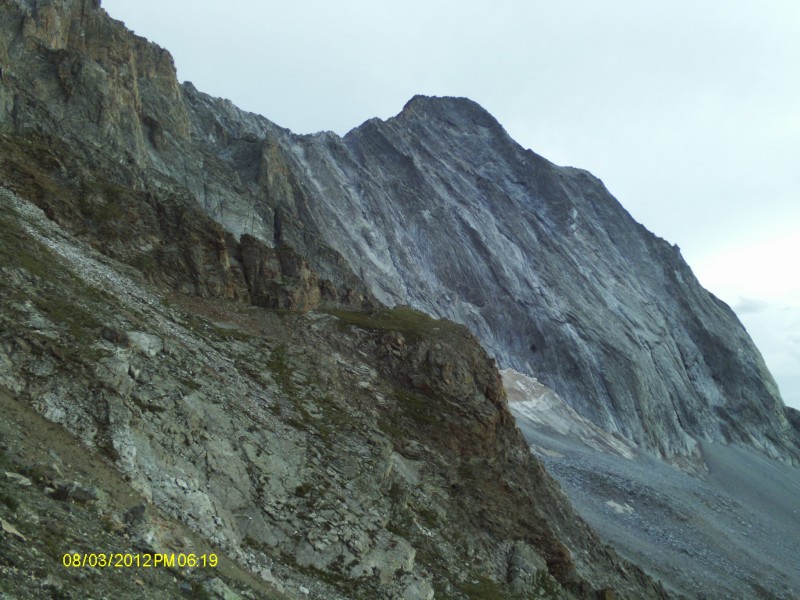
late afternoon view from above the lake
OK. Everybody knows the routine. It's hard. It might be the hardest 14er. There's the Knife Edge. There's only one reasonable route. Yada yada. So I'll limit myself to the things which might not quite correspond to your expectations when and if you first try this spectacular peak.
The Approach
First, we found the distance figures from Roach are all too low (sorry, Gerry). It's at least 13.5 miles from Aspen to the turnoff in Snowmass. When you get there, the road is not signed either as "Snowmass Creek Road," or as County Road 11. The only sign says "Lower River Road." It's something like 10.5 miles from Highway 82 to the trailhead, not 9.5. And we found nothing called the "Capitol Creek Guard Station" at or near mile 8.0. Still, just stay on the "main" road (after turning right onto the Capitol Creek Road, which is signed) as it turns to dirt, and follow it all the way to its end, and you'll arrive at the TH. The last mile or so is steep and rougher than the lower portion, but passenger cars can certainly make it with care, at least if it isn't wet or washed out.
Getting to K2
The trail as far as the Daly/Capitol saddle is clear and in great shape. There are several places where you can cross Capitol Creek (about 3 miles from the TH) without getting wet. It looks like CFI has built new switchbacks above the lake within the last couple of years. Once over the saddle, however, things get less certain.
The trail just disappears a short distance from the saddle, in a loose gulley. This may be the result of a fairly recent washout, as there is a clear length of trail on the other side, as we discovered on the return trip. Finding it heading out, however, is an unlikely proposition. At that point, you'll most likely just have to start freelancing your route to travel under the cliff bands to get to where you can see K2 looming ahead. There are occasional cairns, but the truth is that any path in the right general direction (south) is just about as good as any other. It's rock-hopping all the way.
The Knife Edge
To start across the Knife Edge, you will have to come down off of, or bypass, the actual summit of K2. It's not easy in either case, as the steepness starts here. There's a "low traverse" around the west side, which avoids the summit, or there's the steep descent off the summit, both of which lead to the base of a ridge point where one actually begins the ridge crossing. You can see the beaten path up the north side of this ridge point.
The ridge itself actually consists of several sections which require different techniques. Scooting along on your butt, straddling the top, may not be very elegant, or very fast, but it is clearly the most reliable method for several sections. In between, there are places where grabbing the top with one's hands, and using small (sometimes very small) ledges on the east side for one's feet works best and allows somewhat faster progress. And, toward the south end, there are sections that are wide enough to allow walking on all fours"and bold climbers might actually walk upright. None of it is really technically hard, but the exposure is no joke, so be careful and deliberate instead of trying to set any speed record. (This was my 51st fourteener, and I moved very slowly.)
The Summit Climb
My impression from reading previous reports and descriptions was that the route to the top was just off the actual ridge crest, to climber's left. In reality, the easiest route (which means holding it to Class 4) diverges quite a long way from the ridge crest, and involves some serious route finding. Here again, there are some cairns, but you'll have to look for them. Also, you'll have to cross (while climbing) one gulley of loose dirt and scree. And you can't really see the summit, so you can't tell how far away it is. The general rule is: when in doubt, resist the temptation to break upward toward the summit ridge, and go to climber's left looking for cairns. There's one major corner to turn on the crest of a small ridge. As you approach it, you'll see a cairn, but it looks like it's leading you out into thin air at the top of a cliff. Get there, however, and you'll finally see a path leading steeply up to the right, with cairns visible beyond. It's all steep, and there's a lot of exposure, but (aside from that gulley) most of the rock is amazingly solid. You should finally come to the top of a shallow gulley and out onto the summit ridge just a few yards from the true summit.
I have almost no photos of the most exciting parts of this climb, because my hands were busy doing other things. So I hope this verbal description is helpful. Some of the pictures I did manage to take along the way can be found at:
https://picasaweb.google.com/tcogwr/CapitolPeak
Thumbnails for uploaded photos (click to open slideshow):
Congrats, Patrick and Trish! That was a heck of a long day for you guys! It was nice coming across you guys along the trail on your way down. BTW, your pic link is broken.
for the nice comments, guys.
Matt: Yes, looks like one of the weekends in Sept. for the Handies group.
Kevin: I think the URL for my pics is right, but it also malfunctioned for the first time--but it worked the second time. Hmmm... Yes, we're slow, and that's one reason why this trip was delayed so long!
Caution: The information contained in this report may not be accurate and should not be the only resource used in preparation for your climb. Failure to have the necessary experience, physical conditioning, supplies or equipment can result in injury or death. 14ers.com and the author(s) of this report provide no warranties, either express or implied, that the information provided is accurate or reliable. By using the information provided, you agree to indemnify and hold harmless 14ers.com and the report author(s) with respect to any claims and demands against them, including any attorney fees and expenses. Please read the 14ers.com Safety and Disclaimer pages for more information.
Please respect private property: 14ers.com supports the rights of private landowners to determine how and by whom their land will be used. In Colorado, it is your responsibility to determine if land is private and to obtain the appropriate permission before entering the property.