Download Agreement, Release, and Acknowledgement of Risk:
You (the person requesting this file download) fully understand mountain climbing ("Activity") involves risks and dangers of serious bodily injury, including permanent disability, paralysis, and death ("Risks") and you fully accept and assume all such risks and all responsibility for losses, costs, and damages you incur as a result of your participation in this Activity.
You acknowledge that information in the file you have chosen to download may not be accurate and may contain errors. You agree to assume all risks when using this information and agree to release and discharge 14ers.com, 14ers Inc. and the author(s) of such information (collectively, the "Released Parties").
You hereby discharge the Released Parties from all damages, actions, claims and liabilities of any nature, specifically including, but not limited to, damages, actions, claims and liabilities arising from or related to the negligence of the Released Parties. You further agree to indemnify, hold harmless and defend 14ers.com, 14ers Inc. and each of the other Released Parties from and against any loss, damage, liability and expense, including costs and attorney fees, incurred by 14ers.com, 14ers Inc. or any of the other Released Parties as a result of you using information provided on the 14ers.com or 14ers Inc. websites.
You have read this agreement, fully understand its terms and intend it to be a complete and unconditional release of all liability to the greatest extent allowed by law and agree that if any portion of this agreement is held to be invalid the balance, notwithstanding, shall continue in full force and effect.
By clicking "OK" you agree to these terms. If you DO NOT agree, click "Cancel"...
Peaks
PT 13295 - 403rd highest
PT 13232B - 453rd highest
Pieplant Quad, Sawatch Range
Trailhead
West Winfield - appx 10,380'
From US 24 drive 12 miles west to Winfield, instead of turning south and crossing the bridge to go toward Huron, go straight and park just past the Cemetary (1/2 mile) before the road gets rougher. 4WD can go another 1.5 or so miles (past the LaPlata TH) to the end of the road and a small parking area.
Route
Followed the North Fork Clear Creek Trail to a small creek drainage coming out of Alan Lake near 10900 and up east slopes of PT 13232B, traversed the surprisingly rough ridge to PT 13295, back down to the saddle and down steep slopes to a high basin, then bushwhacked to the trail and out.
Statistics
Appx 11 miles round trip (would be more like 8 miles if you drive to the end of the road)
3535' vertical (would be more like 3100' from end of road)
Why Post?
Posting Trip Reports can be time consuming and with work and play always getting in the way, I have decided to try and only post Trip Reports for peaks that do not have existing trip reports, or for routes that have not been previously reported. These peaks have easy access from Winfield and make a nice half day outing, yet have no Trip Reports previously posted. Also the surprisingly rough ridge made me think it would be good to document this outing for those who may have interest in heading out this way sometime. Its a nice basin out past the more popular peaks, and a great place to find a little solitude surrounded by higher peaks.
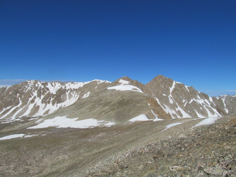
PT 13232 B
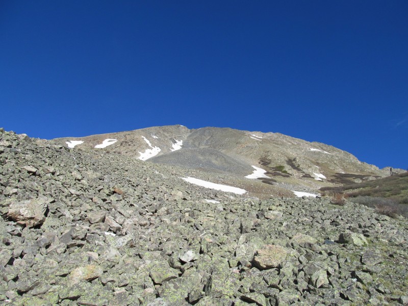
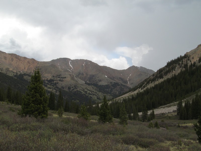
I was looking for a nice half day outing after seeing the forecast for 30-40% chance of thunderstorms after noon. I figured these peaks would fit the bill nicely, and would get me up a couple of new 13ers. I parked just past the cemetery at the first ggod parking space beyond the "High Clearance Vehicles Recommended Beyond This Point" sign, and started walking the road. There were a few other cars along the way, and at the trailhead for LaPlata's south side, but I correctly figured they were all headed to LaPlata and that I would be on my own. After about a mile and half I reached the end of the road, signed in at the wilderness sign and crossed a creek heading up the trail to good views of the day's first objective, PT 13232B.
PT 13232B from Road
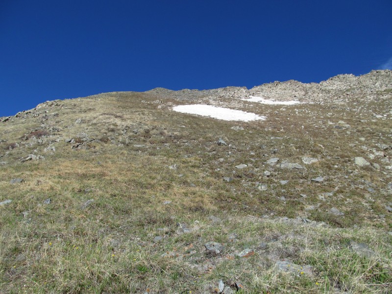
The trail is in good shape, has a couple of creek crossings, but it a pretty strong trail. I left the trail about a mile up just below 10,900' where a creek drainage comes out from Alan Lake and there I took a quick snack break before the terrain would steepen. I then followed the creek trying to stay in open terrain to minimize bushwhacking. I could see the steep slopes above that would lead me to PT 13232B and was able to find a nice path through the intermittent forest, grass and talus to the base of the even steeper slopes above at a small bench near 12,000'.
Ascent from Trail
I picked a line that looked more grass than talus that would get me to the ridge to the right of a small saddle. The slope was steep and relentless, especially after only gaining about 500' in the first 2 1/2 miles - from trail to summit was almost 2400' in less than a mile! Just another Sawatch slog...
Steepening slopes from near 12k
The route was visible from the trail for a while, so I had ample time to prepare, but this one will get your blood flowing. Originally from looking at the map, I thought I would go past the peak and up a more mellow ramp to the south and west of the peak. That would be a reasonable route too, maybe even better, but with more bushwhacking to reach treeline.
Steep grass
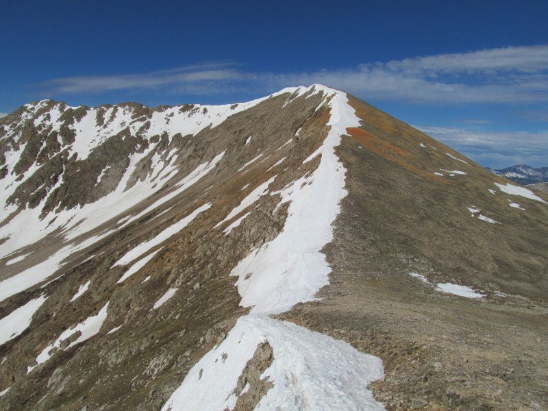
I hit the ridge a little east of the summit. The ridge was class 2 to the summit, and pretty gentle.
Class 2 ridge to summit
The valley I had come up from sure looked a long way down!
Valley from above
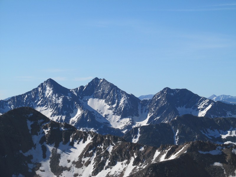
PT 13232 B had a nice summit with good views of the surrounding taller peaks, the Apostles were of course commanding the most attention - as they usually do in this area!
Apostles!
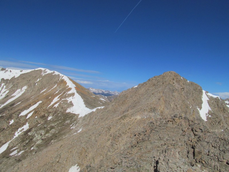
It was a nice place to take a break, but even though so far the skies looked good, I was wary of the forecast and decided to head over and start the traverse to PT 13295.
Traverse
I started west down the class 2 west ridge, the bigger talus near the summit quickly gave way to gentler talus, but there was one short step near the top with some easy scrambling.
Descent
In the way was a false summit labeled as 13172 on the map. From the map, it looked like it would be an easy bump along the way, and at first it looked like it would be a pretty easy romp.
Doesn't look bad
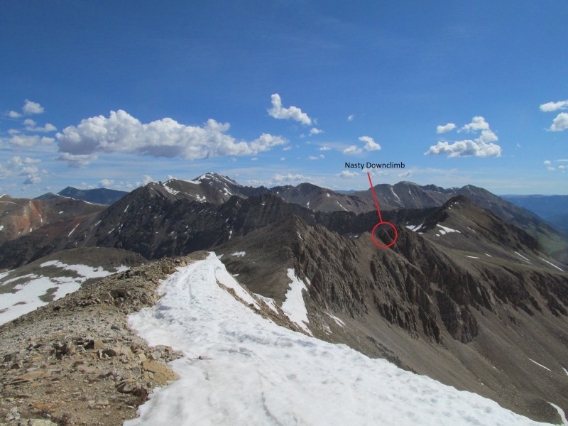
As I got a better look at it and got close, I realized quickly that things could get interesting. The ridge started to get a little scrambly, but initially was enjoyable until I came to a notch.
Getting a little rough looking
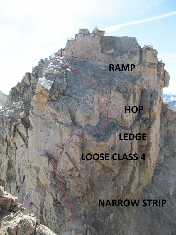
Bamboozled! Hoodwinked! My easy day just took a turn to the interesting and I wasn't sure if I was going to be able to continue. I looked for a way to go down and around, but it seemed like the only way that was going to happen would be to back track all the way to the saddle and go all the way around the south. There may have been another route, but from my position, I just couldn't see a good way. Maybe there is a gully would drop earlier? You might have to drop all the way to 12,400 or lower to by pass this section. Just something to keep in mind.
That seemed too time consuming, but the ridge step seemed too daunting. This was not going to be an easy down climb. There was a sloped slab "ramp" leading to a large step, then a very steep notch that looked from above like it might go. I carefully worked down the "ramp" to the large step, this was a bigger step then I thought with my butt on the rocks and my feet dangling, I couldn't reach the large ledge. I had two choices, hop off and commit to the rest of the notch, or go back. I debated it and decided I could down climb if I committed, and hopped onto the ledge.
Now came the stiff class 4 (or more) down climb, I could see holds and I could patch a route together, the problem was that the rock ended up being rather loose. Ah crap. I poked at some loose stuff with the trekking pole and my feet and got to the solid stuff, but it made my holds farther apart now. I turn and face in, grip a solid edge and gingerly lower myself to the small holds and work my way to a narrow strip of rock to reach the small col. Looking back at the step, the first thing that came to my head was "don't me ask how I got down that thing", but it went something like this:
Don't ask, I don't know either...
On the other side I had to reclimb 3rd class terrain, a little loose but far better than what I just came down. The ridge kept going in this manner, but not knowing what was coming on the back, and not wanting another notch I made a vow to myself to take the first exit I could find to bypass this crappy tower and get to the PT 13295 saddle.
Up the other side
That opportunity presented itself in the form of a series of class 2 ledges that I hoped would continue around a couple of blind corners. It did, until the final one where I had to down climb a steep loose gully (2+) and then scramble class 3 back to the ridge crest.
Gully descent
Looking back
I turned around to see what difficulties I had just bypassed on the ridge crest, and I was hoodwinked again! The backside of that tower was easy class 2. I couldn't believe it, but that is how it goes sometimes. Some of these routes on the 13ers are about looking at the map and then winging it as you go along. I thought this was going to be a nice class 2 traverse, so the surprises on the east side of the ridge, left me wanting to skip the west side "just in case", but it turned out those concerns were unfounded.
Easy ridge after all!
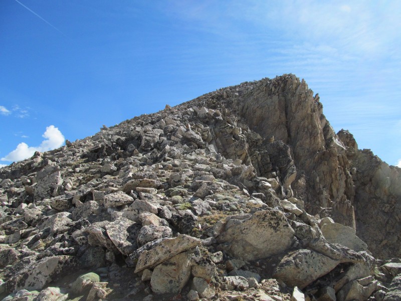
The rest of the way to PT 13295 was a piece of cake, but it did start to present a problem, snow and a cornice in the saddle was going to make the descent interesting later.
Up PT 13295
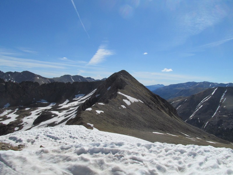
For now it was time to take a quick break on the summit and enjoy the views. By now some clouds were building in the distant west a few white puffs were building around the area, I figured I had time, but I wanted to move quick because these things can build quickly (and did it ever!). There was a nice looking couloir on the back of Jenkins, and distant views to the Elks from the summit:
Might want to ski Jenkins, nice couloir!
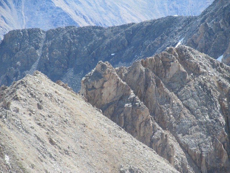
Looking back at the tricky tower from the summit had me at first thinking I found the way off the ridge, a nice class 2 talus strip coming off the ridge. Until I zoomed closer and realized it was on the wrong side of notch!
Looking back at the traverse
Zoom of notch.
Nasty downclimb zoom
Descent
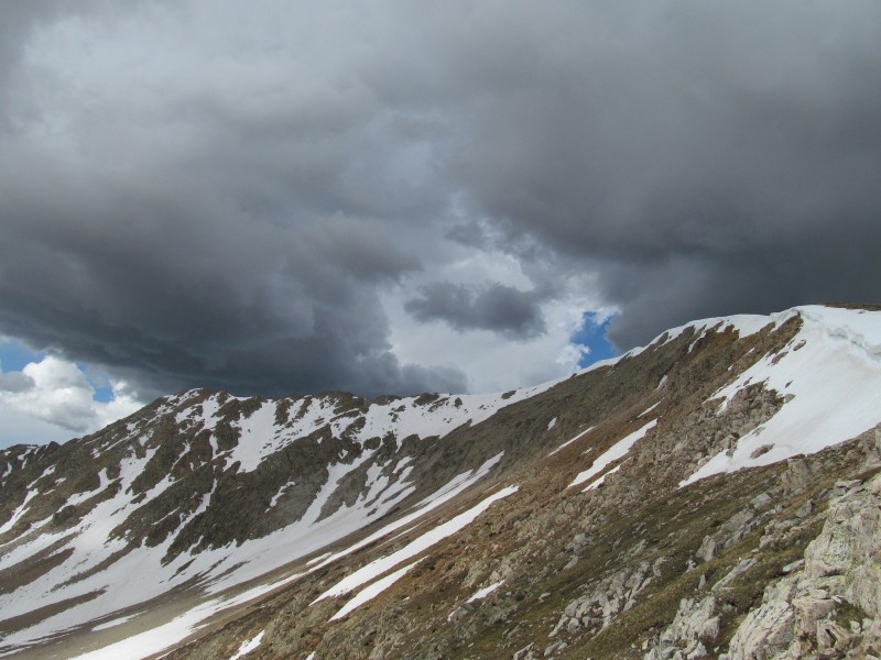
My original plan was to descend via the saddle, but the cornices had me thinking maybe not, the other option was to descend south-southeast towards a ridge point at 13015 and down that way, but it seemed out my way and I wanted to go before the clouds got organized. So back to the saddle I went. I didn't like the looks of the cornices, so ended up reclimbing slightly past them and scrambled down into a steep loose gully and to the long flat basin that would lead me back to the trail. I turned back to look at the summit and saw it enveloped in black clouds! Wow, these storms can build quick! I was just up there in good weather less than a half an hour ago! Just crazy...
30 minutes off the summit...
I booked across the flats to some light sleet, looking back at the peak and my downclimb on the way:
Looking back at the saddle (descent to right of snow)
I then did a descending traverse though the trees and picked up the trail. No more precipitation, but still black clouds building to the north and west. LaPlata and Sayres sounded like they were getting hammered as I head thunder in that direction despite it not quite being 11.30. I passed the parking lot and saw all the same cars (and then some) that I had seen at 6.30 when I passed it the first time. I hope everyone got down safely!
Getting dark to the north!
I made it to the car at 4 minutes to noon, my "be at the car by noon" day worked, and despite some clouds, thunder and light sleet managed to beat the storms. The drive back I saw black clouds and heavy precipitation over Sherman and drove through some heavy rains near Leadville. I guess after all I picked a good pair of peaks to sneak in before the weather, but the ridge around PT 13172 certainly caught me off guard! Its amazing some of the surprises you can find sometimes when you head to the mountains, not every notch and tower shows up on the contours, and sometimes you have to improvise!
Thanks for reading, hopefully my antics on the ridge will be helpful for the next poor sap who gets hoodwinked into thinking Sawatch ridge traverses are easy...
Thumbnails for uploaded photos (click to open slideshow):
This looks much more interesting.
Thanks for the beta on some peaks that would make a fine outing for the indecisive hiker hanging out among the sea of Sawatch 13ers.
This is what I'm talkin' about .. 6/14/2012 2:20pm
Potential situations involving something ”narrow” and ”loose” with a ”hop” involved. Always love those things involving ”HOPS”. 8) :wink: Appreciate the information ... there's quite a few of those stragglers I need to get in that area. Thanks for posting. Happy trails! :D
Don't you just love it when an easy stroll turns into something like that. That picture of your downclimb looks scary ugly. In hindsight, what is the best way to avoid that part when combining these two peaks?
Thanks for the report, I still need to climb those.
Thanks for the kind words. It was an interesting day and definitely caught me by surprise around those towers. The notch does indeed ”go”, but barely!
Steve- If you look at the photo with the notch circled, you can see a grassy looking ramp to the right with a couple of talus gullies coming off it, you could use one of those and side hill below the difficulties and climb up to the saddle once past. If the sidehilling was too loose, you'd just have to drop a little further (maybe 12,300?) to get to the bench below it all (see image 21). There may be other options on the ridge before the notch, but you'd have to traverse ledges across the face and it would probably be faster to just drop, more elevation gain though, but these are pretty easy stat-wise so probably not a big deal.
Last fall I climbed these plus 13140 and Jenkins, I came at it the from the west, I took one look at the tower and said ”oh $%^&.” I found a way around on the grassy ramp, it only involved one class 4 move and a cliff hugging traverse then smooth sailing the rest of the way. I was just praying that the ramp led somewhere good and it did. I just love surprises in the Sawatch
Caution: The information contained in this report may not be accurate and should not be the only resource used in preparation for your climb. Failure to have the necessary experience, physical conditioning, supplies or equipment can result in injury or death. 14ers.com and the author(s) of this report provide no warranties, either express or implied, that the information provided is accurate or reliable. By using the information provided, you agree to indemnify and hold harmless 14ers.com and the report author(s) with respect to any claims and demands against them, including any attorney fees and expenses. Please read the 14ers.com Safety and Disclaimer pages for more information.
Please respect private property: 14ers.com supports the rights of private landowners to determine how and by whom their land will be used. In Colorado, it is your responsibility to determine if land is private and to obtain the appropriate permission before entering the property.