Download Agreement, Release, and Acknowledgement of Risk:
You (the person requesting this file download) fully understand mountain climbing ("Activity") involves risks and dangers of serious bodily injury, including permanent disability, paralysis, and death ("Risks") and you fully accept and assume all such risks and all responsibility for losses, costs, and damages you incur as a result of your participation in this Activity.
You acknowledge that information in the file you have chosen to download may not be accurate and may contain errors. You agree to assume all risks when using this information and agree to release and discharge 14ers.com, 14ers Inc. and the author(s) of such information (collectively, the "Released Parties").
You hereby discharge the Released Parties from all damages, actions, claims and liabilities of any nature, specifically including, but not limited to, damages, actions, claims and liabilities arising from or related to the negligence of the Released Parties. You further agree to indemnify, hold harmless and defend 14ers.com, 14ers Inc. and each of the other Released Parties from and against any loss, damage, liability and expense, including costs and attorney fees, incurred by 14ers.com, 14ers Inc. or any of the other Released Parties as a result of you using information provided on the 14ers.com or 14ers Inc. websites.
You have read this agreement, fully understand its terms and intend it to be a complete and unconditional release of all liability to the greatest extent allowed by law and agree that if any portion of this agreement is held to be invalid the balance, notwithstanding, shall continue in full force and effect.
By clicking "OK" you agree to these terms. If you DO NOT agree, click "Cancel"...
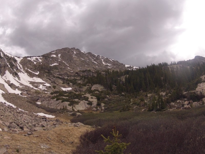
The trail to the lake is a steady but highly-runnable grade, from just over 9000' to just under 11000' in 2.5 miles. So in half an hour, we were standing at the lake, with our first views of Whitney Peak.
Whitney Lake
We were happy to find a pleasantly aesthetic peak worthy of our time.
As for routes, two obvious possibilities stood out: the constant grade of the southeast ridge, which looked promising but had some unknown terrain hidden behind the trees (left of picture); or a run along the northeast ridge (right of picture) which had a few open scree slopes that seemed manageable.
In either case, a fair amount of bushwhacking was required to start, so we headed counterclockwise around the lake. Ultimately, our route could best be described as fumbling around blindly until treeline, where we lucked out onto wide-open tundra slopes of the southeast ridge, where the rest of the climb was an obvious Class 2+ and the weather was still great. SE shoulder tundra
Everything's coming up Milhouse!
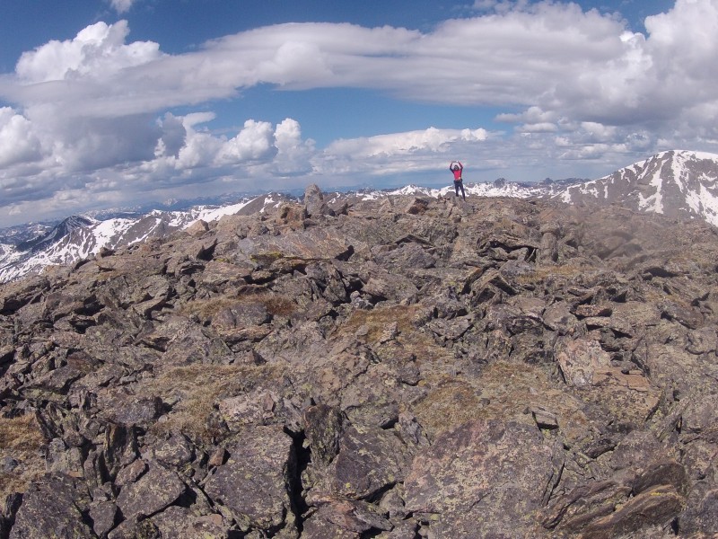
After a bit of tundra walkup, we had some alternating snowfields, stable talus and boulder climbing, and even some solid slabs, we topped out near a rocky pile on the otherwise expansive flat of the summit plateau. Talus
Higher points were evident in the distance, so we traced along the talus of the ridge, including a prominent notch on the summit that lead directly down into an artful couloir.
Farther along were the real summit(s), then: first, a large, smooth boulder just tall enough to be a 5.6 climb and which was a candidate for the summit. This boulder shall not be discussed further. More to the west, a seemingly equivalently tall summit pile directed our attention. It is here that both a USGS marker and summit register are placed. Summit plateau
3rd and 4th summits of the year.
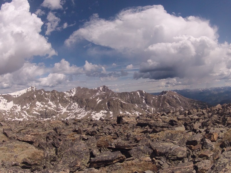
We enjoyed superb views to the North of Halo Ridge that leads to Mount of the Holy Cross: some other day. Holy Cross Ridge
Although the weather was better than forecasted for the morning, rain was evident to the south with clouds building around us. Nick saw a flash of lightning in the distance. Time to head down.
We debated our options, and decided it was easy enough to head down into the drainage above Whitney Lake. We should then be able to take a direct line to the lake; quick and easy. Eastern Face from drainage
Above treeline, we had some fun scrambling, running, and shoe skiing.
At treeline, then, we began the bushwhack anew. It began with some fun, runnable sections on game trails, but then, Holy Cross Wilderness spun it's well-deserved reputation as being the Bermuda Triangle of Colorado, with the lake eluding us despite our extensive, fumbling search for it.
At least we were in the trees when the lightning, thunder, and sleet approached.
Alternately splitting up and coming back together, mucking through marshes, and relying on our speed, endurance, and stubbornness rather than map-reading and planning, we arrived back at the lake, satisfied that we covered every square-inch of non-lake prior, with an additional half-mile in the log to boot.
Finally, a fun cruise back down the trail. Some wildflowers were knee-high and will be three times as tall next month, while groves of aspen will be on fire in September -- this is a spectacular place for the summer and fall. A lesser-visited summit, but definitely recommended.
Thumbnails for uploaded photos (click to open slideshow):
There's always been a controversy about the true summit of Whitney Peak. FWIW, it's been water-leveled by others (and my GPS) and it appears that the harder boulder is the true summit. But it's a very close call as you know. Anyway, great report and pics!
-Tom
Thanks for the bit of info, Tom -- the OCD part of me wishes we took turns hoisting each other up, but I'm content with the register and USGS marker. Mostly!
Absolutely, no intent to diminish your accomplishment! Just fyi I came up from the Holy Cross 4WD road, gotta say I really love that area. Great report!
-Tom
I've gotta hit this area sometime. Looks like a great one.
I probably wouldn't be able to keep up with you guys, but if you're interested in teaming up for some good distance ones in the Ft Collins area like Stones/Sprague, Elks Tooth/Ogalalla, Sawtooth/Algonquin/Red Deer, let me know. Thanks!
Caution: The information contained in this report may not be accurate and should not be the only resource used in preparation for your climb. Failure to have the necessary experience, physical conditioning, supplies or equipment can result in injury or death. 14ers.com and the author(s) of this report provide no warranties, either express or implied, that the information provided is accurate or reliable. By using the information provided, you agree to indemnify and hold harmless 14ers.com and the report author(s) with respect to any claims and demands against them, including any attorney fees and expenses. Please read the 14ers.com Safety and Disclaimer pages for more information.
Please respect private property: 14ers.com supports the rights of private landowners to determine how and by whom their land will be used. In Colorado, it is your responsibility to determine if land is private and to obtain the appropriate permission before entering the property.