Download Agreement, Release, and Acknowledgement of Risk:
You (the person requesting this file download) fully understand mountain climbing ("Activity") involves risks and dangers of serious bodily injury, including permanent disability, paralysis, and death ("Risks") and you fully accept and assume all such risks and all responsibility for losses, costs, and damages you incur as a result of your participation in this Activity.
You acknowledge that information in the file you have chosen to download may not be accurate and may contain errors. You agree to assume all risks when using this information and agree to release and discharge 14ers.com, 14ers Inc. and the author(s) of such information (collectively, the "Released Parties").
You hereby discharge the Released Parties from all damages, actions, claims and liabilities of any nature, specifically including, but not limited to, damages, actions, claims and liabilities arising from or related to the negligence of the Released Parties. You further agree to indemnify, hold harmless and defend 14ers.com, 14ers Inc. and each of the other Released Parties from and against any loss, damage, liability and expense, including costs and attorney fees, incurred by 14ers.com, 14ers Inc. or any of the other Released Parties as a result of you using information provided on the 14ers.com or 14ers Inc. websites.
You have read this agreement, fully understand its terms and intend it to be a complete and unconditional release of all liability to the greatest extent allowed by law and agree that if any portion of this agreement is held to be invalid the balance, notwithstanding, shall continue in full force and effect.
By clicking "OK" you agree to these terms. If you DO NOT agree, click "Cancel"...
Trailhead: Sandbeach Lake TH (Rocky Mountain National Park)
Route: SE Slopes (Class II)
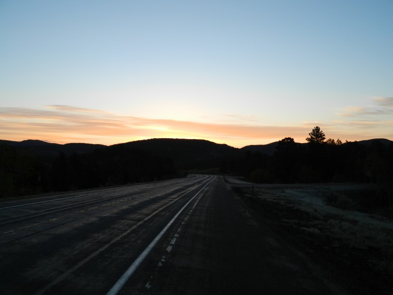
I arrived at the trailhead just before 6am on a clear Sunday morning in the park. I was able to enjoy a beautiful sunrise on the drive in along Highway 7. Since it was still before Memorial Day, the Ranger Station was still "Abandoned for the Winter." Mine was the first car at the trailhead, and I knew I would have solitude for most of the day since probably 98% of the people who take this trail stop at the lake.
Sunrise on Highway 7 en route to the trailhead Trailhead
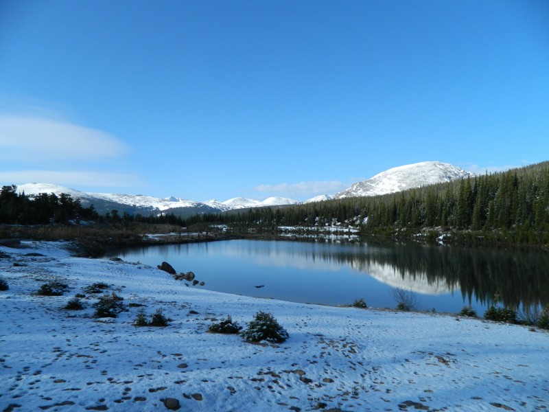
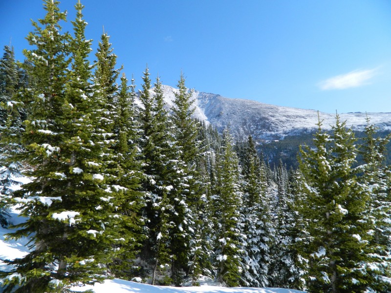
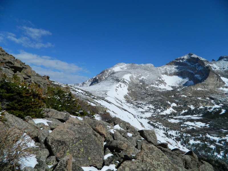
I made quick work of the 4.5 miles up to Sandbeach Lake (knowing that I needed to be off the mountain in plenty of time to make my 6:45 flight to Fresno for work the next week). The trail was snow-free until the last half mile before the lake. I arrived at the lake at 7:40 and enjoyed the fresh coating of snow that the area had received the day previous. After downing a Clif Bar and some trail mix, I donned my gaiters for the bushwhack up to Mt. Orton. Once I reached treeline, I was rewarded with the less-often-seen southern views of Pagoda, Longs, and Meeker. Chiefs Head also came into view for the first time.
Sandbeach Lake Route up Mt. Orton Fresh coat of snow on the pines Pagoda, Longs, Meeker (L to R) Chiefs Head (center) and Pagoda
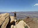
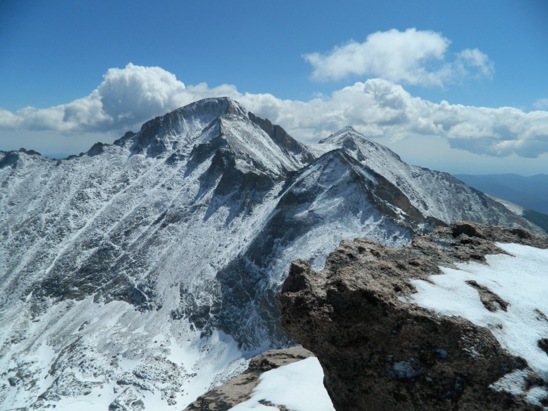
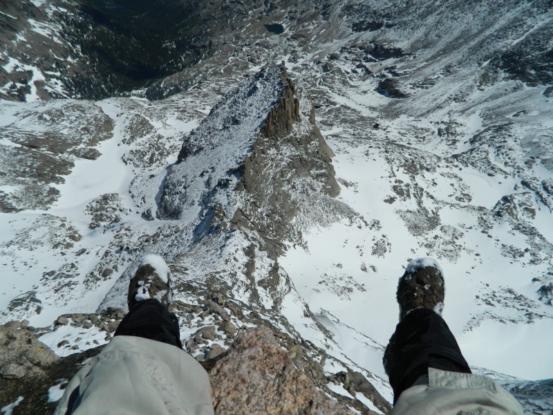
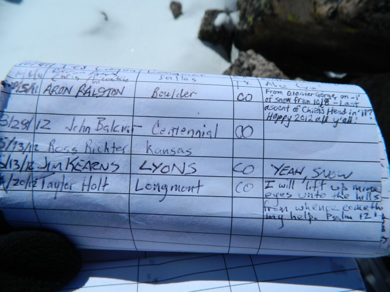
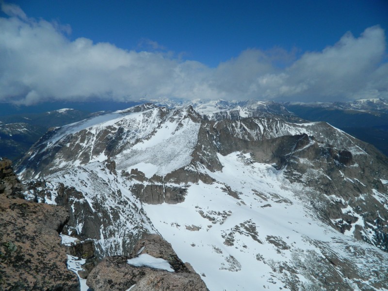
Once the summit of Mt. Orton is visible, the route flattens out significantly for the next ~.75 miles. I chose to skirt around the east side of Orton, but a quick scramble up to the summit is certainly available. The south side of Chiefs Head provides a pretty straightforward class II ramp up to the summit. In most of the other trip reports I've read, people headed to the right side of the ramp in order to gain the ridge, but I preferred just heading up the center in a direct line to the top. I reached the summit at 10:40, and I must say that it's one of my top five favorite summit views. Glacier Gorge to the North, Longs massif to the East, Wild Basin to the South, and McHenrys to the West. Of course, I had to take the classic photo of feet dangling off into Glacier Gorge. After the photography was complete, I signed the summit register, and couldn't help but notice the name a couple up from mine. Good prediction Aron of being the last summit of 2011!
Longs massif from the summit of Chiefs Head The classic summit shot looking down at Spearhead Summit self-photo Nice prediction Aron McHenrys Alice
I was blessed because the recent snowfall was not enough to hinder my progress at all, and it enhanced the views tenfold.
Clouds began moving in during my descent, but none of them were threatening (just cooled off the temps a little bit). The eastern slopes of Mt. Orton made for an excellent glissade on my way back to Sandbeach Lake. When I ventured out of the trees back at the lake, I saw the first people that I'd seen all day and enjoyed a quick lunch before heading back down the 4.5 miles of trail to my car. I returned to my vehicle at 2:30 pm, plenty of time to make it home, shower, and catch my flight to California.
Thumbnails for uploaded photos (click to open slideshow):
I especially loved the shot of McH and Arrowhead. It gives an excellent view of the terrain below from Stone Man Pass to Black Lake which I may attempt later this summer. Thanks for the great report, Lemmi! :D
I hope to do Chief's Head by the same route in July and your report was very helpful. (I'd also like to do it in the same amount of time as you did, but there's no way that will happen! :wink: You made great time for a 16 mile round trip hike.) The views into Glacier Gorge are fantastic.
Awesome pictures, how was the snow from Sandbeach to treeline? After climbing Orton by this route a few years ago, I've been really thinking about continuing up the North Ridge as you did
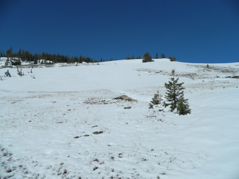
The snow was in pretty good shape. Some minor postholing in the trees. However, once you reach the obvious clearing shown in Image 4, it was easy to kick steps and not deep enough for postholing the rest of the way to tree line. This area also provided some good short glissade sections for the trip down.
With the temps the way they have been though, a lot of this snow has probably melted off by now.
I've lived in CO for 21 years, and have been dreaming about climbing Chiefs Head. Lately I've been doing more research on the route and looking at trip reports, hoping to try it later this summer (2017). Thanks for the excellent report and pictures. I especially like your summit register post!
Caution: The information contained in this report may not be accurate and should not be the only resource used in preparation for your climb. Failure to have the necessary experience, physical conditioning, supplies or equipment can result in injury or death. 14ers.com and the author(s) of this report provide no warranties, either express or implied, that the information provided is accurate or reliable. By using the information provided, you agree to indemnify and hold harmless 14ers.com and the report author(s) with respect to any claims and demands against them, including any attorney fees and expenses. Please read the 14ers.com Safety and Disclaimer pages for more information.
Please respect private property: 14ers.com supports the rights of private landowners to determine how and by whom their land will be used. In Colorado, it is your responsibility to determine if land is private and to obtain the appropriate permission before entering the property.


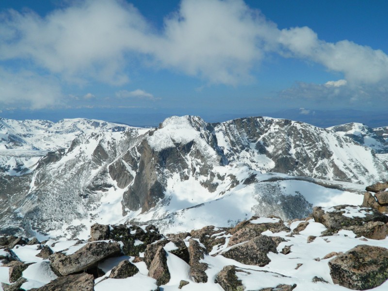
 Clouds moving in on the Wild Basin area")