Download Agreement, Release, and Acknowledgement of Risk:
You (the person requesting this file download) fully understand mountain climbing ("Activity") involves risks and dangers of serious bodily injury, including permanent disability, paralysis, and death ("Risks") and you fully accept and assume all such risks and all responsibility for losses, costs, and damages you incur as a result of your participation in this Activity.
You acknowledge that information in the file you have chosen to download may not be accurate and may contain errors. You agree to assume all risks when using this information and agree to release and discharge 14ers.com, 14ers Inc. and the author(s) of such information (collectively, the "Released Parties").
You hereby discharge the Released Parties from all damages, actions, claims and liabilities of any nature, specifically including, but not limited to, damages, actions, claims and liabilities arising from or related to the negligence of the Released Parties. You further agree to indemnify, hold harmless and defend 14ers.com, 14ers Inc. and each of the other Released Parties from and against any loss, damage, liability and expense, including costs and attorney fees, incurred by 14ers.com, 14ers Inc. or any of the other Released Parties as a result of you using information provided on the 14ers.com or 14ers Inc. websites.
You have read this agreement, fully understand its terms and intend it to be a complete and unconditional release of all liability to the greatest extent allowed by law and agree that if any portion of this agreement is held to be invalid the balance, notwithstanding, shall continue in full force and effect.
By clicking "OK" you agree to these terms. If you DO NOT agree, click "Cancel"...
When I was looking into this route, everyone I asked if they had climbed it said "where's that?" And I had asked many people who have been climbing in CO for a long time. The route was not in Dawson's book, it's not listed in the routes on this site, and I couldn't find a trip report for it on this site (at least by searching for 'south paw' for Torreys and Grays). So even though this route is on a such a popular peak, it's apparently not climbed that often. That was appealing to me.
Roach states the route is steeper than Dead Dog and is usually protected by a cornice with the typical exit to the left. I figured a low snow year was a good time to try it, given the cornice should be composed of mainly wind blown, hard snow. I figured I'd just give it a try. South Paw on the left, Dead Dog on the right
With the forecast predicting a storm coming in about mid-day and temps in the 20s, I figured the snow wasn't going to soften much throughout the day. Murphy's Law didn't work, the storm was either late or fairly wimpy, at least in Stevens Gulch. The max temp I saw on my thermometer was 35 degrees, downright balmy! The sun was in and out behind the clouds, mostly behind the clouds I would say. By the time I left at 3:30 pm, it hadn't started snowing yet. Some wind blown snow was coming in from other areas, but it didn't actually snow in the basin all day. So much for weather forecasts.
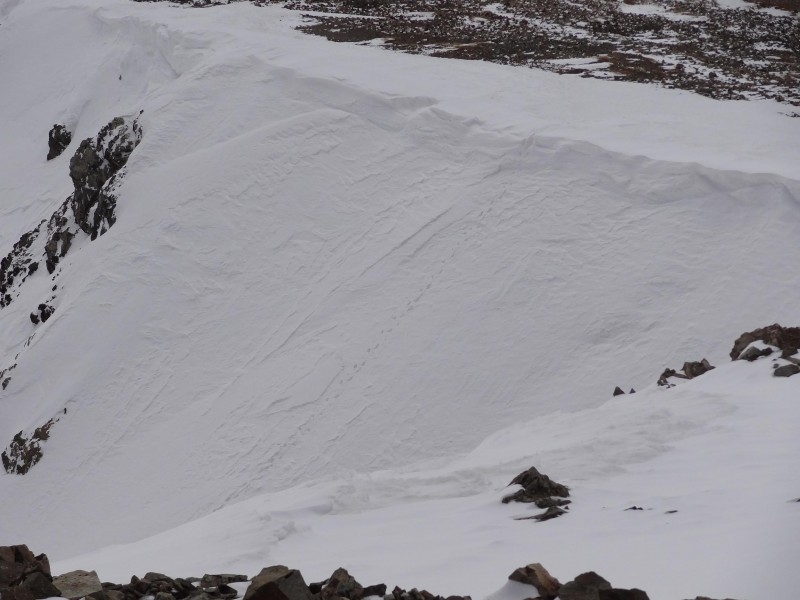
South Paw is south of Dead Dog (hence south - paw, sticking with the dog theme).
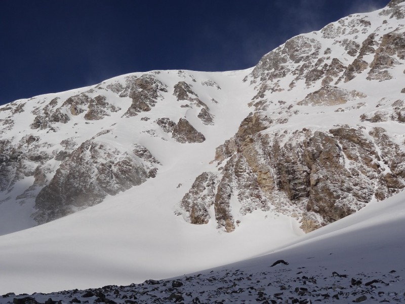
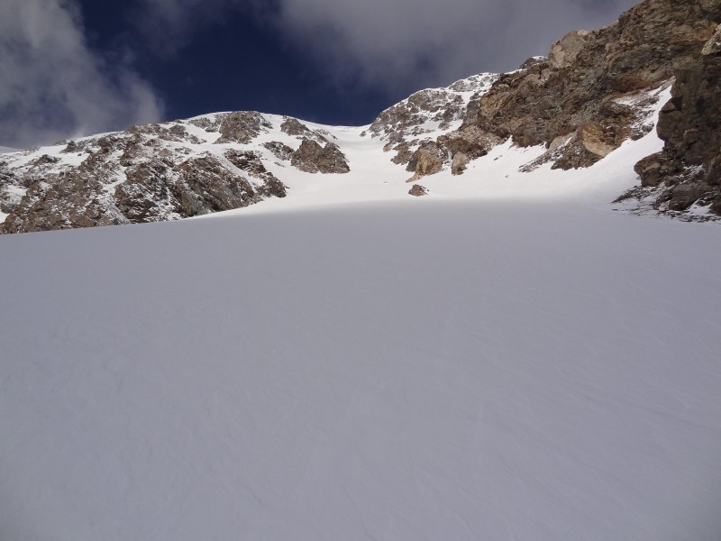
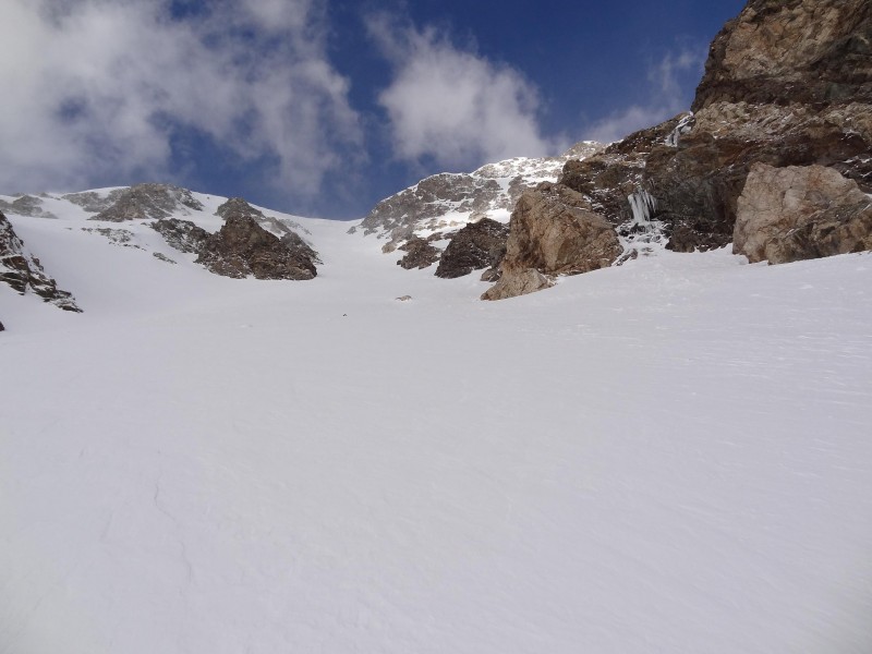
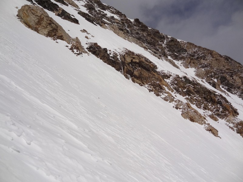
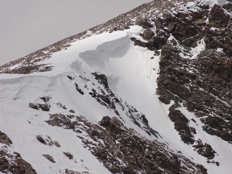
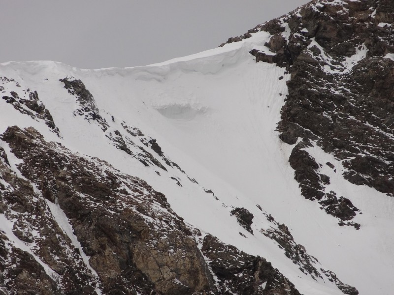
It's shorter than Dead Dog, and at least this year, had a really large apron below it. After getting above the apron and into the couloir, the angle was 35 degrees. A little further above near two sets of rocks on climbers left that protruded into the basin, the angle was 40. Further up, I measured 45. Below the sets of rocks below the cornice, I measured 50. The angle increased only slightly immediately below the cornice. The cornice itself (at least where I decided to climb it), was fairly thin and required only two or three kick steps to get over it. Those last steps were nearly on top of each other, I couldn't see the steps below, so it was near-vertical. South Paw with a large apron of snow below it Close-up of the cornice Closer on the cornice, get a good look before you enter, chose your line
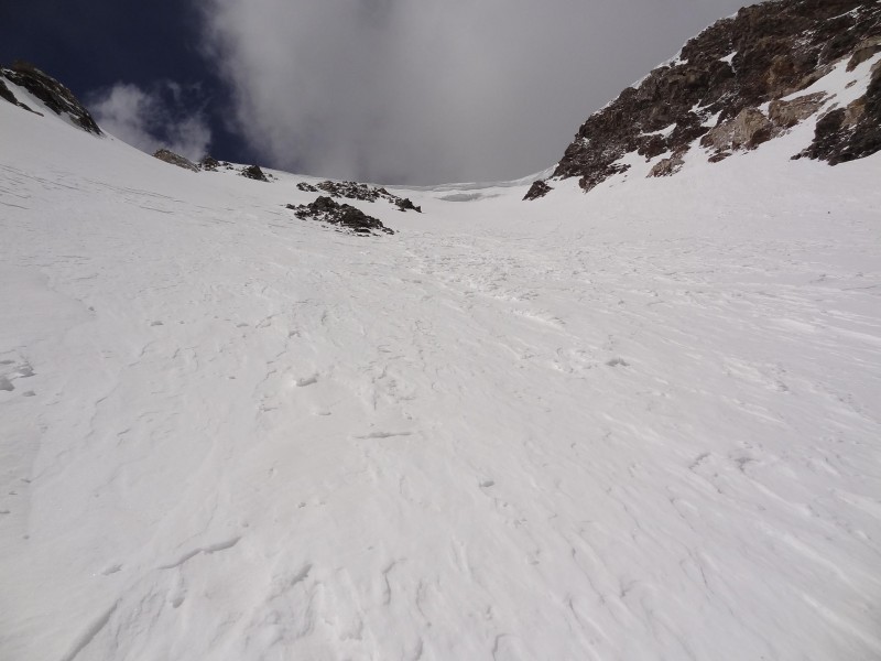
The snow was in decent condition. There was generally a layer of recent snow on top of bulletproof snow below. The recent snow made a nice cushion and provided full-foot support as long as I wasn't front-pointing. It was a great way to save the calves for further up. In some areas, and especially near the top, the recent snow was thicker (maybe wind blown) and created that annoying slip surface that made it harder to bite into the bulletproof snow below, this is where front-pointing was needed to get a good hold. Overall though, the snow was pretty good, I was happy for the recent snow instead of an entire couloir full of bulletproof snow. Almost off the apron and into the couloir I climbed just right of the rocks just left of middle, then basically straight up from there 40 degree snow Looking down from the same place as the shot above I climbed almost straight up from center. Couloir is actually concave, apparent convex is from stitching
For folks worried about the cornice shedding large amounts of snow during a climb, if you stick left, there are two sets of rocks protruding into the couloir that may protect climbers below for about half of the couloir. Above that though, if the couloir sheds, you're likely to be in the way.
The couloir itself is fairly straightforward. For the exit, the cornice on the right side is overhung and you can see some layering, some thin. No way I would climb that side unprotected but other climbers certainly have more will than I. I stayed left but still on the snow. Roach says the rocks on the left can be used to exit. But at least this year, they didn't go all the way to the top. You can use them to mostly avoid the cornice, but not entirely. The cornice itself wasn't bad, not too thick, and there appeared to be many places to allow a safe exit. The steeper snow right below the cornice and the cornice itself were very solid. On the cornice, I had no fears of wedges of snow failing and sending me back down the couloir. I used my hybrid ax on the cornice to provide two 'hands', which was nice, gives an extra comfort factor getting on that last two or three steps getting over the top. Hopefully you can see my footprints up the middle of the pic
Overall I think South Paw was a great snow climb. Due to the cornice, I wouldn't recommend trying it on a day after a questionable freeze. Otherwise, give this route a try, it's a lot of fun. Or, the next time you're headed up to Dead Dog and see too many people in the couloir above you, check out the cornice, then head left (south) and try South Paw. Two hikers near the cornice give perspective
Thumbnails for uploaded photos (click to open slideshow):
Darrin, no worries, I'll figure out something for which to blame you! :lol:
Bill, that's the problem with hiking/climbing alone, no one else is around to get pics of people in action! Shucks. :D
Glad we didn't screw this up for you. 4/16/2012 9:47pm
When I saw the forecast for the weekend I was worried you wouldn't get it and then blame us for making you repeat hope last weekend! :lol: Great report, Kelly!
If only you knew the story behind ”Muffy”, Darin...but you'd have to have climbed with someone from KANSAS to know.
Muffy- I almost fell out of my chair when I saw that!
Can't believe you let 'Muffy' out of t 4/16/2012 11:45pm
Caroline, you may now have to explain that one since you let it out! In order to get photos of people doing funny things, people have to climb with me! And yes, that means I have to tell people my plans. Oh wait a minute, that's what I did last weekend and 'people' changed the objective. See why I keep my mouth shut. :lol: Yes, missed opportunity to get good pics. Getting a pic of someone getting over that cornice would have been cool. Then again if you want to laugh just go look back at all those comments from the pic from last weekend, that will elicit laughs for a long time to come! :lol:
Wait a minute, Darrin spelled screwed wrong and I didn't catch it? That's what I get trying to reply quick before work. Lost opportunity to give Darrin a hard time, frick! :( Yes, Darrin is certainly skewed, esp since he's from Kansas.
...is how Kansan's spell screw, in case you missed it. :wink:
Darrin, we run into each other enough in the hills that we don't need to climb together. Two Dar(r)ins on one climb might be too much anyway.
But it is fun for me to pick on you because you're from Kansas.
Now that you got the word out, it may actually get climbed more! Nice pics and great description.
Stupid forecast on Sat made me miss my plans, so glad that a bunch of people stuck to their guns to get out! Of course I had a 'bit of a drive' after Sat activities to worry about.
We'll have to get a group to go out again, so we can get more funny pics and stories again!
I tackled this route last year, and will go down as one of my favs. Great climb! After that last bottle neck, looking up at the cornice overhanging you, that's when your in it to win it or emptying out the bottom, talk about steep! I definitely swallowed my heart a few times before the top out.
Caution: The information contained in this report may not be accurate and should not be the only resource used in preparation for your climb. Failure to have the necessary experience, physical conditioning, supplies or equipment can result in injury or death. 14ers.com and the author(s) of this report provide no warranties, either express or implied, that the information provided is accurate or reliable. By using the information provided, you agree to indemnify and hold harmless 14ers.com and the report author(s) with respect to any claims and demands against them, including any attorney fees and expenses. Please read the 14ers.com Safety and Disclaimer pages for more information.
Please respect private property: 14ers.com supports the rights of private landowners to determine how and by whom their land will be used. In Colorado, it is your responsibility to determine if land is private and to obtain the appropriate permission before entering the property.

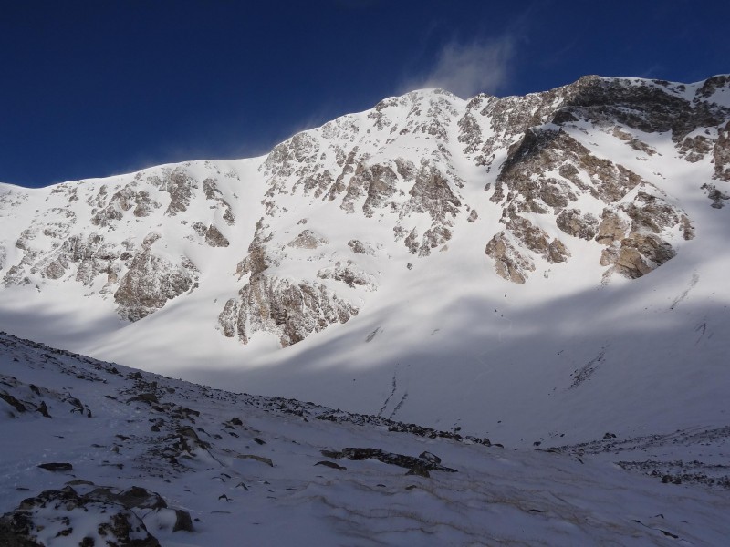
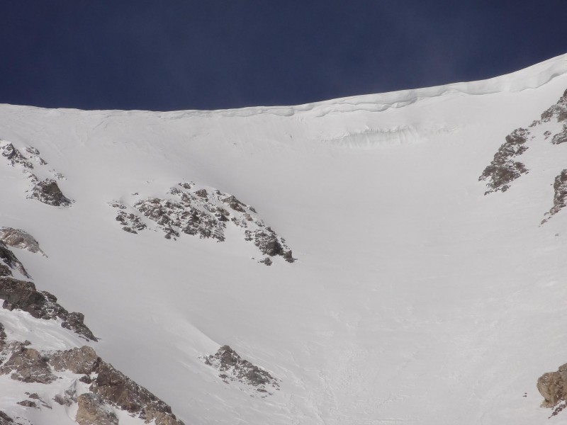


 South Paw on the left, Dead Dog on the right")
")
 South Paw with a large apron of snow below it")
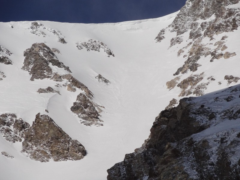
 Close-up of the cornice")
 Closer on the cornice, get a good look before you enter, chose your line")
")
 Almost off the apron and into the couloir")
 I climbed just right of the rocks just left of middle, then basically straight up from there")
 40 degree snow")
 Looking down from the same place as the shot above")
 I climbed almost straight up from center. Couloir is actually concave, apparent convex is from stitching")
 Hopefully you can see my footprints up the middle of the pic")
")
")
")
")
")
 Two hikers near the cornice give perspective")
")
")
")