Download Agreement, Release, and Acknowledgement of Risk:
You (the person requesting this file download) fully understand mountain climbing ("Activity") involves risks and dangers of serious bodily injury, including permanent disability, paralysis, and death ("Risks") and you fully accept and assume all such risks and all responsibility for losses, costs, and damages you incur as a result of your participation in this Activity.
You acknowledge that information in the file you have chosen to download may not be accurate and may contain errors. You agree to assume all risks when using this information and agree to release and discharge 14ers.com, 14ers Inc. and the author(s) of such information (collectively, the "Released Parties").
You hereby discharge the Released Parties from all damages, actions, claims and liabilities of any nature, specifically including, but not limited to, damages, actions, claims and liabilities arising from or related to the negligence of the Released Parties. You further agree to indemnify, hold harmless and defend 14ers.com, 14ers Inc. and each of the other Released Parties from and against any loss, damage, liability and expense, including costs and attorney fees, incurred by 14ers.com, 14ers Inc. or any of the other Released Parties as a result of you using information provided on the 14ers.com or 14ers Inc. websites.
You have read this agreement, fully understand its terms and intend it to be a complete and unconditional release of all liability to the greatest extent allowed by law and agree that if any portion of this agreement is held to be invalid the balance, notwithstanding, shall continue in full force and effect.
By clicking "OK" you agree to these terms. If you DO NOT agree, click "Cancel"...
With 5 of the hardest peaks left to finish the 14ers, I had resigned myself to the fact that they would have to wait until late spring and summer of 2012. I planned on spending the winter going after 13ers and increasing my overall mountaineering skillset. My plan for climbing Little Bear had been to attempt it in the spring as a snow climb, in hopes that the Hourglass would be full of snow and holding the deadly rockfall in place. The Hourglass is a narrow couloir that constricts in the middle, with any and all rockfall funneling exactly where you are doing the crux climbing on the route. After hearing too many stories of near-misses and actual accidents there, I wanted to climb it when conditions were as safe as possible.
However, this winter has been different, having very little snow. With winter 1/3 over, many mountains are still in late fall condition. This is especially true in the southern Sangre De Cristo range. For this climb I didn't need my snowshoes, microspikes, crampons, or ice ax (which I carried anyway, of course).
Matt and I were lamenting the weekend weather and avalanche forecasts on Thursday morning when I remembered Kevin Baker's trip report from last week. After quickly checking the weather, I asked him if he would be up for trying the Southwest ridge route of Little Bear. He thought I was joking. This route avoids the Hourglass altogether, adds a summit of South Little Bear, but is not necessarily an easier route. The traverse from the South summit to the official summit is called the "Mama Bear Traverse", and it is not to be taken lightly, even in the summer with no snow. Despite being under the weather, Matt agreed that we would be fools not to at least give it a shot. Alarm clock set for 11:45pm, and with thoughts of Little Bear dancing through my head, I dozed off for a whopping 2 hours. Headed out the door at midnight for the drive to the trailhead, which is a term I use very loosely, as you just park at the corner of two 4wd roads.
Sunrise San Luis Valley
We left the car at 8,800ft at 5:15 and started the brutal bushwack up the Tobin Creek drainage to gain the SW ridge. This has been said before, but I will repeat it again, cross Tobin Creek no higher than 9,200ft to avoid the steeper terrain higher up. There is a very vague route up to the ridgemarked by surveyors tape, but in the dark it was just something we would occasionally happen upon, and then just as fast lose it again. After the bushwacking it was very nice to finally gain the ridge and be able to just talus hop.
Start of ridge Talus on ridge Talus on ridge
Matt was dragging behind at this point and it was very obvious he was sick as a dog and getting worse with every step. While waiting for him around treeline I realized that at this pace we would be doing almost the entire descent in the dark, not good when there is no trail to follow. By the time Matt made it up to me, he had decided today was not his day. Class 3 and 4 climbing while sick and weak would be a dangerous combination, and the mountain isn't going anywhere. He definitely made the right call. We parted ways after confirming his GPS knew where the car was and agreeing to try to check in every hour with my progress. It was just after 9am at this point.
My goal was to be on the top of South Little Bear by noon in hopes of completing the traverse in both directions and getting back below treeline before dark. I was feeling great and moved up the ridge fairly quickly, stopping only to chase down my helmet which the wind blew off my pack. Luckily I was able to find it, or my day would have been over before even getting a glimpse of the peak. Just before the point around 12,900ft, I finally got the view I had only seen in pictures.
First glimpse of Little Bear Bam! Clouds over Ellingwood Point Little Bear Little Bear from summit of Pt. 13,133 Going down? Little Bear Clouds obscuring view of ridge
This is one intimidating mountain, that's for sure, and it is easy to see why it I considered to be one of the hardest 14ers. From this point the rest of the route became visible, and I still had a long way to go. After a slew of pictures from Point 13,133, I began the steep climb up to South Little Bear, this was about half difficult class two and half class 3. Once again I was thankful for my long legs when forced to straddle and scoot over the knife edge section. This part of the climb was surprisingly difficult with the snow and ice, but I made it to the south summit at 12:04, just in time. The views from here were amazing and I was staring right at the Mama Bear Traverse. I had read that it takes about an hour each way for the traverse, and that is almost exactly how long it took me.
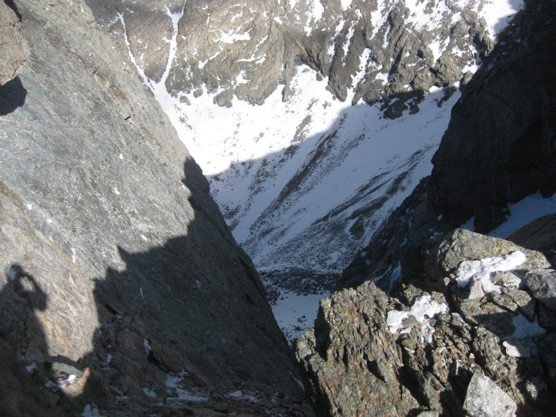
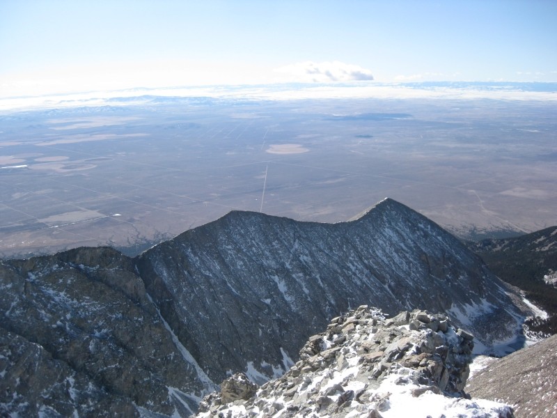
Summit of Little Bear Looking down the Hourglass Ellingwood Pt and Blanca Peak Look back at travers to/from South Little Bear
The crux of the traverse for me was the initial downclimb off of South. Due to the snow and ice making the ledges look none too inviting, I chose to stay directly on the ridge crest for probably 85% of the traverse. This meant more knife edges and climbing up and over towers, but it seemed much safer than playing Russian roulette on those loose, icy ledges. I apologize for the lack of pictures during the traverse, but I was busy staying alive, as this was certainly a no-fall-zone.
Blanca and Nt. Lindsey Ellingwood Pt. Made it!!!!!!!!
At exactly 1:00 I pulled myself up to the 14,037ft summit of Little Bear Peak!! I was, and still am, in shock and amazed that I had just climbed Little Bear, solo, and in calendar winter. After taking pictures, signing the register, sending a few texts, having a Phish "Divided Sky" dance party, hooting and hollering, eating a Snickers, and taking in the amazing views of the nearby 14ers and the San Luis Valley, I got ready for the descent. The fact that I was only half way done with my day and with a few more hours of serious climbing ahead before I was out of the danger zone quickly got me focused again.
shot of LB-Blanca traverse Lake Como Ridge Traverse
I reversed the traverse, which was easier this time because I had already made the routefinding mistakes on the way over, but it still took almost exactly an hour, topping out again on South Little Bear just after 2:00.
The class 3 downclimb was my last significant climbing of the day, and I was very relieved to finally make it back to point 13,133 unscathed. The race against sunlight was now on. Trying to move fast I almost forgot to turn around and take in the peak I had just climbed. Stopping for a rest at about 12,900ft I was able to stop and just stare at the mountain, jaw-dropping is an understatement.
Little bear on left, South Little Bear center Looking down towards Lake Como Loooonnng ridge Little Bear Lake
The sun was getting low, so I pushed on and made it treeline just as it was setting. It is always really cool to take pictures of sunrise and sunset on the same day, with a great hike or climb in between. I wanted to stop and take a long break, but the increasing wind and darkness forced me to suck it up and keep trudging along.
While on the summit of Little Bear I had thought about the other reports on this route. Everyone complained about how long the ridge was and just in general how tiring it was and how long it took. I scoffed at them and actually thought to myself 'this isn't too bad at all, the others were greatly exaggerating'. The descent , however, had me echoing their sentiments exactly. It took me almost as long for the descent as the ascent, which seems like it should be impossible. The last couple hours of blind bushwacking was the epitome of torture and I was so relieved to finally make it to the car just before 8. It had taken me 14.5 hours to go 8.5 miles and gain about 6,000ft in elevation, but I had climbed Little Bear!
One last look Sunset but far from done
Of course things never go perfectly, and Matt reported that the car battery was dead. Doh! Long story short, we waited 3 hours and eventually got jumped by an Alamosa police officer. I didn't climb into my bed until almost 4:30am, but I am NOT complaining.
So now I have 4 left on 'the list': Capitol, Pyramid, North Maroon, and Crestone Peak. I feel more than ready for these tough climbs ahead and shouldn't have a problem finishing them up by the end of this summer. Getting to summit Little Bear, in calendar winter, is definitely one of my biggest accomplishments in climbing thus far, and I look forward to whatever adventures come next. The only thing I would change about this trip would be for Matt to have made it, but honestly, I am impressed he even made it as far as he did with how sick he was. I have no doubt he will get Little Bear sooner than later.
Thanks for reading!
Thumbnails for uploaded photos (click to open slideshow):
Way to get it in winter. It IS remarkable, isn't it, how this route takes so long for even the fastest of climbers? 8 miles and 6k just doesn't get the point across.
Iman86, sorry you caught that cold and had to turn around. I hope you go for it again in the coming weeks.
Stong work man. 8) I'm impressed and really wish I could've come! Funny thing, the stats for LB and our recent trip to Mt Yale/Mascot are actually about the same on paper, but are oh-so-different in actuality!
Glad you were able to enjoy a Snickers 1/23/2012 4:05pm
Achievement is not measured by the number of summits attained, but by the number of Snickers consumed (which I suppose is directly related for you) :lol:
The fact that it took you 14.5 hours to go 8.5 miles and gain about 6,000ft in elevation really speaks to the difficulty of this climb.
Great job dude and I really enjoyed the report!
Hope you get it soon Matt...perhaps look at the NW face for summer.
Well done Aaron! Way to get after it this fall and winter - you are an animal! Hope we can get out again sometime. And I like that you had a Phish dance party on the summit, now that's how you do it :)
It really must be a very difficult climb, congratulations, your report is awesome, I like the pictures. Hope to climb sometimes with you again. Good luck for the remaining beasts 8)
Abe - I think I will just head back there when I am feeling better. Little Bear in summer doesn't really interest me. The SW Ridge in winter is where it is at for me. :P
Amazing view of LB from 12,880ft, isn't it? 4/2/2015 7:45pm
in fact, for me, it was worth climbing the ridge the second time just for that view.
Caution: The information contained in this report may not be accurate and should not be the only resource used in preparation for your climb. Failure to have the necessary experience, physical conditioning, supplies or equipment can result in injury or death. 14ers.com and the author(s) of this report provide no warranties, either express or implied, that the information provided is accurate or reliable. By using the information provided, you agree to indemnify and hold harmless 14ers.com and the report author(s) with respect to any claims and demands against them, including any attorney fees and expenses. Please read the 14ers.com Safety and Disclaimer pages for more information.
Copyright: Route information, text, risk factors, maps, GPX files, charts, photos, 14ers.com-created map imagery, flythroughs, and other content provided in this route description are copyrighted by 14ers.com and may not be copied, reproduced, republished, distributed, modified, or used to create derivative works without prior written permission.
Please respect private property: 14ers.com supports the rights of private landowners to determine how and by whom their land will be used. In Colorado, it is your responsibility to determine if land is private and to obtain the appropriate permission before entering the property.