Download Agreement, Release, and Acknowledgement of Risk:
You (the person requesting this file download) fully understand mountain climbing ("Activity") involves risks and dangers of serious bodily injury, including permanent disability, paralysis, and death ("Risks") and you fully accept and assume all such risks and all responsibility for losses, costs, and damages you incur as a result of your participation in this Activity.
You acknowledge that information in the file you have chosen to download may not be accurate and may contain errors. You agree to assume all risks when using this information and agree to release and discharge 14ers.com, 14ers Inc. and the author(s) of such information (collectively, the "Released Parties").
You hereby discharge the Released Parties from all damages, actions, claims and liabilities of any nature, specifically including, but not limited to, damages, actions, claims and liabilities arising from or related to the negligence of the Released Parties. You further agree to indemnify, hold harmless and defend 14ers.com, 14ers Inc. and each of the other Released Parties from and against any loss, damage, liability and expense, including costs and attorney fees, incurred by 14ers.com, 14ers Inc. or any of the other Released Parties as a result of you using information provided on the 14ers.com or 14ers Inc. websites.
You have read this agreement, fully understand its terms and intend it to be a complete and unconditional release of all liability to the greatest extent allowed by law and agree that if any portion of this agreement is held to be invalid the balance, notwithstanding, shall continue in full force and effect.
By clicking "OK" you agree to these terms. If you DO NOT agree, click "Cancel"...
Friday the 13th, January 2012
13.1 miles
~5,750' gain
11.5 hours
East Ridge route, from Rainbow Trail
My friend and I met up in Longmont at 3:15am, excited to tackle a Sangre in this unusually snow-less winter! His back had been feeling weak the past few days, but after a few chiropractic sessions, he wanted to give it a shot.
We were able to drive 0.3 miles past the "winter closure," aka where it gets plowed to apparently. We wanted to try driving up past this spot too, but this next 1.5 miles was private property, so we would hafta make it past that to park. After like 0.1 miles of sketchy, deeper snow, we immediately dismissed this idea! So we backed up and parked at the "Private Property" sign & parking area. We hit the trail at 7:10am, sunrise on Humboldt giving us instant motivation. TH
We walked a few minutes in the open South Colony road, then soon hit the trees. Going into the trees
The road was snowmobile-packed, very easy to walk. Occasionally Marble or Humboldt would peek out and taunt us through the trees! Marble Humboldt
After about 2.2 miles, we hit the Rainbow Trail sign at 8:40am, and turned right just past the sign to start heading to Humboldt. Is this a bad sign?
The Rainbow Trail was pre-packed (thank you, other hikers!) and usually easy to follow. Every now and then there was a fallen tree that we got to maneuver around. Under Over (photo by my friend)
Soon we were close to the first, low ridge. We hiked up a small hillside and saw a cairn, where we then stashed our snowshoes that we were carrying (never used). At the cairn (on the ridge), turn left (southwest) and follow this ridge through the trees. There are a few scattered cairns, but the ridge is pretty easy to follow. Gain the low ridge First cairn, turn left.
Soon the trail suddenly gets steeper. Nice, finally some GAIN! A good workout
We were able to follow the packed trail still, through the denser trees. Occasionally I wasn't paying attention and I'd follow too closely, and a branch that got slightly caught on my friend's pack would whip back and smack me in the face. "Okay, don't tailgate. Got it!" In the trees
As Bill's description states, after you get out of the trees, the route-finding is much easier. Totally true, and I would imagine route-finding without a packed trail through those trees would have been a slight pain.
The forecast said 15-25mph winds, with 35mph gusts. Eh, whatever. You can expect that on a mountain ridge any day. But before we left the trees, we hadn't felt a breeze at all, and certainly enjoyed the sunny, pleasant day! Outta the trees, there's Humboldt!
Out of the trees, Humboldt's false summit comes into view. At about this time, my friend's back was slowing him down significantly, and he didn't want to injure himself, so he decided to head back to the car. Bummer! He made a wise but painful decision, and I'm proud that he did. We decided that I should head up to Humboldt and meet him at the car, sending SPOT messages to his phone every now and then.
It was 11:30am at 11,800', and I was ready to rock. I hiked up to & along the ridge. Gain the ridge on the left and go up! The view on the ridge, working toward the false summit
That wasn't too bad at all. As you crest the false summit, Humboldt's summit finally shows itself in the distance! "Can You See Me?"
The wind was picking up dramatically. From about the false summit to just before the summit, it was blowing me all over the place. Occasionally it would let up on me, but I could still hear it slapping against Humboldt's north face as I ascended the ridge. Yay! Going up the bump
After the first bump, there wasn't enough snow to fill the rocks, so I got to enjoy some class 2+ moves on the ridge. Fun! But the wind was making me move much slower to be sure I didn't get blown off! Almost there. Winds must be 40-50 mph gusts
2:05pm: Summit! It kinda snuck up on me. The wind kept me distracted from the summit to focus intently on being safe with each move/step. And magically, the wind died way down on the summit. Awesome!
And of course, the moment you wait for the whole time you climb Humboldt's East Ridge... THE CRESTONES!!
But, what the heck, some of Humboldt's fat is blocking the view. So I jaunted over for about 10 minutes towards the false summit (the other one, on Humboldt's west side), until I got a less obstructed view: Zoomed in a touch Marble Mountain Kit Carson Mountain Beautiful Sangres Mt. Adams
Victory! So glad to be here!
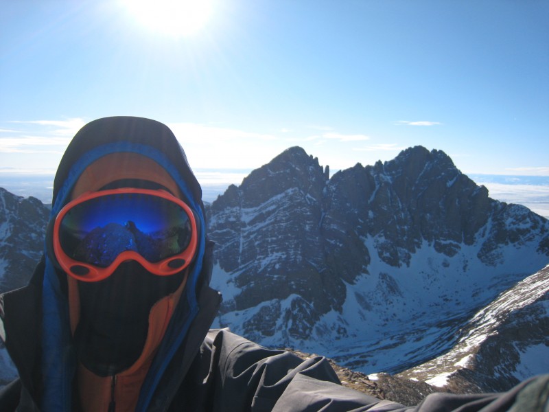
Okay, enough pretending. Really it was like this: I'm smiling under all that clothing!
I headed back over to the summit, ate a snack, and was off by 2:55pm to re-enter the gusty ridgeline. Descending was fun & fast. The ridge on the way down from the summit
Colony Baldy from along the ridge: Colony Baldy. What a great name.
Dunes: Humboldt casts a large shadow
After returning to treeline, it was not obvious where our path was, since the snow was all wind-swept and we wore microspikes (spikes only leave tiny prints on hard snow slabs). So I spent like 15 minutes searching for our tracks (the packed trail), because my GPS randomly erased my track since our start. What the heck, GPS? And why now, when I'm by myself??
After some searching back & forth while praying, postholing and exploring, I was at a loss. Finally I decided to play around with my GPS and see if I could somehow find the track I had been setting since we started, and VOILA! God answered my prayers! Turns out I was just 10 feet from our path. WHEW!!!
I hauled balls down the path, through the trees along the lower ridge, so I didn't keep my friend waiting too long, and so I could get as much done in the remaining light as possible. I made it just before the snowshoes before putting on the headlamp, retrieved my snowshoes a couple minutes later, and was home-free following the packed trail. Thank you, God!
The hike out solo in the dark was enjoyable, but I would have preferred to have my buddy there with me, to talk about how much fun that was and help time pass. We will tackle it again, soon, when his back is back in shape!
Back at the car at 6:40pm, and we drove home with a little Subway stop in Colorado Springs. (I find it funny to watch people's reactions when we walk into a food shop all beaten up and in our climbing clothes... they must think either, "What did THEY just do today?" or "Are they homeless?")
Great trip, highly recommend this route with plenty of studying of the path so you don't get lost through the trees (and a GPS!)
Thumbnails for uploaded photos (click to open slideshow):
Fantastic climb- I really enjoyed the pictures. Would you recommend the Rainbow Trail route for a summer climb? I would love to take a crack at Humboldt via Rainbow, then take off toward Kit Carson and Challenger. Does that sound crazy?
I am planning to do Mt Adams, Fluted Pk, and Little Horn in two weeks so your pics looking that way were very helpful to get an idea of what the conditions are like up there right now. :D
That gentle ridge can be a real pain in the wind, eh? Sweet shots of the Crestones from the subsummit. Let me know if you plan anything for February or March. It's been almost a year, Brad. Unacceptable!
Caution: The information contained in this report may not be accurate and should not be the only resource used in preparation for your climb. Failure to have the necessary experience, physical conditioning, supplies or equipment can result in injury or death. 14ers.com and the author(s) of this report provide no warranties, either express or implied, that the information provided is accurate or reliable. By using the information provided, you agree to indemnify and hold harmless 14ers.com and the report author(s) with respect to any claims and demands against them, including any attorney fees and expenses. Please read the 14ers.com Safety and Disclaimer pages for more information.
Please respect private property: 14ers.com supports the rights of private landowners to determine how and by whom their land will be used. In Colorado, it is your responsibility to determine if land is private and to obtain the appropriate permission before entering the property.


 TH")
 Going into the trees")
 Marble")
 Humboldt")
 Is this a bad sign?")
 Under")
 Gain the low ridge")
 First cairn, turn left.")
 A good workout")
 In the trees")
 Outta the trees, there's Humboldt!")
 Gain the ridge on the left and go up!")
 The view on the ridge, working toward the false summit")
")
 Yay!")
 Going up the bump")
 Almost there. Winds must be 40-50 mph gusts")
")
")
 Zoomed in a touch")
 Marble Mountain")
 Kit Carson Mountain")
 Beautiful Sangres")
 Mt. Adams")
 So glad to be here!")
 I'm smiling under all that clothing!")
 The ridge on the way down from the summit")
 Colony Baldy. What a great name.")
 Humboldt casts a large shadow")
 Over (photo by my friend)")