Download Agreement, Release, and Acknowledgement of Risk:
You (the person requesting this file download) fully understand mountain climbing ("Activity") involves risks and dangers of serious bodily injury, including permanent disability, paralysis, and death ("Risks") and you fully accept and assume all such risks and all responsibility for losses, costs, and damages you incur as a result of your participation in this Activity.
You acknowledge that information in the file you have chosen to download may not be accurate and may contain errors. You agree to assume all risks when using this information and agree to release and discharge 14ers.com, 14ers Inc. and the author(s) of such information (collectively, the "Released Parties").
You hereby discharge the Released Parties from all damages, actions, claims and liabilities of any nature, specifically including, but not limited to, damages, actions, claims and liabilities arising from or related to the negligence of the Released Parties. You further agree to indemnify, hold harmless and defend 14ers.com, 14ers Inc. and each of the other Released Parties from and against any loss, damage, liability and expense, including costs and attorney fees, incurred by 14ers.com, 14ers Inc. or any of the other Released Parties as a result of you using information provided on the 14ers.com or 14ers Inc. websites.
You have read this agreement, fully understand its terms and intend it to be a complete and unconditional release of all liability to the greatest extent allowed by law and agree that if any portion of this agreement is held to be invalid the balance, notwithstanding, shall continue in full force and effect.
By clicking "OK" you agree to these terms. If you DO NOT agree, click "Cancel"...
The next morning dawned cold--though not excessively so--and clear.
The rosy glow of early dawn from inside the basin
Terry and I wasted little time in rousing ourselves and starting out. We decided to follow the advice to make use of the snowfields in the basin, and hopped onto the nearest one just below our campsite. A few places necessitated clambering briefly over rocks, but by and large it made for a nice, easy, and gradual ascent that soon brought us close to the base of the peak. At a shoulder beyond which the snowfield became part of the Sky Top Glacier and dove down into a tarn, we left the snowfield and began making our way through the large boulders on the lower slopes of Granite Peak.
Looking back down the valley from the top of the snowfields just after dawn The route--taking a sudden turn for the straight up--after the snowfields. It's go time...
We stayed at the right edge of the screeish terrain below Granite, soon reaching a narrower section that was choked with snow. We found a class 2+ weakness in the rocks to the left, took it, and soon had easily bypassed the snow. Onward to the slab!
Pilot Peak and haze in the distance
The slab, a giant area of smooth rock visible from a distance on Granite's south face, is the key to this route. Its blackened lower left corner is essentially the start of the SW couloir. We traversed the slab's base on easy scree (not as steep as it looks from below), turned right at the far end, and picked our way a short distance through loose bands of rock until the SW couloir came into view.
Looking back at the traverse below the slab The SW Couloir, coming into view at last! The bus-sized chockstones seen here are bypassed by class 3 scrambling to the R, al
From what we could see of it, it looked pretty dry. However, one section had a few SUV-sized boulders blocking any possible progress. We had to pop onto a slightly airy 3rd-class rib of rock to climber's right of the couloir to bypass it.
From here, things were straightforward for a few hundred feet. The gully itself was full of loose rock, but it was mostly merely annoying. Still, bring helmets for the gully, and use them--we did. About halfway up, we reached the crux of the route, at least on that day: several boulders at a choke point in the couloir, partially coated with verglas--the "rime ice" we'd been warned about. Carefully, we proceeded.
Terry navigating one of the trickier, verglas-covered parts of the couloir
The last move to surmount these boulders involved a very awkward and committing move I'd put at class 3+, and very similar to the tougher parts of the approach to 14er Sunlight Peak's summit block. It would probably be a bit easier without the verglas, though. Past this spot, we again had easy going up loose scree until the top of the gully.
Nearing the top of the couloir, with ~150' to go. If you stay R, it's easier than it looks!
The terrain from the top of the gully to the summit is somewhat confusing, though I'll attempt to describe it here. The gully has been making its hidden ascent upward and to the right on the large south face of Granite, and at its uppermost end, is defined by a ridge that ascends and curves around to the left. This ridge, not clearly discernible from the Sky Top Lakes, is separated from the true summit ridge by a steep cleft, with the two converging at the upper left side of the face. At the top of the gully, the ridge is thus at its lowest at climber's right, and should be accessed here unless you want to up the difficulty of your climb to 4th/low 5th class. I found that gaining this rightmost part of the ridge was in fact very easy and straightforward class 3 scrambling, and suddenly, I was on top of the ridge. The views down the other side literally took my breath away...
Topping out, to a sea of white... A long way down to the Sky Top Glacier and its tarn
I waited for Terry to join me, then we set off on the last part of our journey. I'd heard many different things about the last ridge, but I found it overall to be fun. Where it was tricky, it wasn't exposed, and where it was exposed, it wasn't tricky. In fact, I was amazed at how many parts of the ridge weren't exposed at all! We started off staying R of the ridge crest on some easy and fun ledges, then were forced back onto the crest as the ridge curved around the top of the couloir. Here, we reached a spot where we could see the summit--and a few people on it--nearby, but across a gaping chasm of sheer cliffs.
The top coming into view--and a few people are already on the summit Exposure on the ridge above the couloir. Almost entirely avoidable, though
Past this spot, we reached another awkward pitch up a sort of dihedral (class 3+), then some easier ledges.
Terry on a difficult section of ridge
One spot reminded me of the ledge on the Sawtooth route on Evans, though easier and less exposed. Cairns guided the way from here up to the crest of the ridge, which soon mellowed out and joined with the summit ridge.
...Cairn to nowhere? Haze over nearby peaks Terry topping out on the last bit of ridge before the summit ridge There's the top--only a bit of scrambling to go!
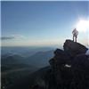
We made the exhilarating class 2 scramble and, a few minutes later, stood atop Montana.
The views easily rivaled anything in the San Juans...broad plateaus, rugged cliffs, imposing peaks, and alpine lakes stretched off in all directions under a bluebird sky. Sadly, we couldn't see the distant Tetons that day, but we could see most everything else! To the south, the peaks stretched off into the haze (presumably from forest fires--the only thing keeping the views from being any more perfect). To the north, Froze-to-Death Plateau, Mount Wood and the already-autumnal rolling plains of central Montana, some 9000' below.
Summit views of Mt. Wood, Montana's 2nd-highest peak So. Much. Granite... Pilot Peak and a sea of Wyoming mountains beyond...
The view down Granite's sheer north face was daunting, and even looking down the standard route from Tempest was enough to give one vertigo!
Looking down the sheer north face of Granite. Yikes! The standard route up Granite. Can anyone say "vertigo"?
Terry and I spent a bit of time relaxing on the summit and chatting with the half-dozen or so other climbers there. Most seemed to be locals, some had never done a technical climb before, and all seemed as elated to be there as Terry and I were.
Terry and I, atop Montana
I could've stayed up there for hours, but Terry seemed anxious to leave, so down we went. We managed to retrace our steps fairly easily, and were soon on our way back down the couloir. I found myself tending to stay on the more solid rock on descender's left whenever possible. We reached the choke point, and I let Terry go first. I waited till he'd moved out of the way to safety, and luckily so since I unfortunately couldn't help sending some rocks tumbling down on my descent!
Terry nearing the top of the slab on the descent
We made it back to the rock rib atop the slab, and I gingerly made my way down it, crab-style, trying to ignore the daunting exposure on my left. I breathed a little sigh of relief once we were back on the scree and traversing below the slab.
Descending the valley. You can see the series of snowfields we traversed in the uppermost basin
We made short work of the descent past the snowy area, remaining scree, and area of large boulders, and were soon back on the snowfield. We descended on the now-slippery snow, mostly just by foot; I tried a few half-hearted glissades, largely unsuccessfully. We were soon back at camp, it being around noon.
About an hour and a half later, I'd changed into shorts, we'd packed up, and were ready to go. We mostly retraced our steps, except for opting for a higher route to avoid most of the snowfields around the 3rd Sky Top Lake.
The Spectacular Sky Top basin
When we reached the final treacherous snowfield on the way out, I noticed our tracks from the previous day had already disappeared. I sighed, snapped on my microspikes again, and made my slippery way across the snowfield to safety. My waypoint led us true to our old route, and we were soon back at Rough Lake.
Just magical...but we still have miles to go before we sleep Lakeside beauty
I spoke with Terry about whether he wanted to camp one more night, or try to make it out to the car. He decided on the latter, and even wanted to drive home right afterwards! I was game, but we still had many miles to cover, and at least some of them would be in the dark...
After a slight wrong turn between Rough and Lone Elk lakes, we were back on track and making good time. We departed the upper basin with a few hours of daylight left, taking a last look at the distant peaks in the afternoon sun. Now, we returned down the hill to the meadows, past the rough section of trail, and back to the meadow with the difficult stream crossing.
Passing through flowery meadows on our way out
I was glad to find the logs much drier this time around, and we could now simply walk across them. We had about an hour left now until sunset, and were racing the clock.
Down, down we went, and sometime around sunset, we made it back to the main trail that would lead us back to our car. However, we still had probably 4 miles to go, and I was more nervous about the threat of grizzly bears, especially in the dark. We booked it over the small pass, along the meadows, and into the woods again, hurrying our way toward Lady of the Lake. At last, as darkness was setting in, we reached the lake--and it was a whole different kind of beautiful. The lake's still waters reflected the silent pines and stars alighting the cold night sky as a luminous moon hung overhead. Truly, this was quintessential Montana.
Despite the chill in the air, I stubbornly decided to keep wearing my shorts (whether out of a desire to experience my last hours in Montana more fully, or out of sheer laziness, I'll let you decide!). I did finally succumb to putting on my headlamp, though. Terry and I now had only an hour or so's hike back to the car. We passed a large group camped near the lake, roaring campfire going. It looked inviting...but after greeting them, we pressed on. There was one last 200' hill to surmount, but it felt like ten times that. I kept telling Terry that we "had to just about be to the top", only for us to find disappointment around the next bend. I also began to notice that my headlamp was barely illuminating anything around me, which necessitated me staying right behind Terry (I had another headlamp somewhere in my pack, but didn't get it out due to laziness--I'll give you that one for free). At long last, we crested the hill. As we traversed below the small, now moonlit cliffs once more, I could also see out into the vast valley separating us from Wyoming, and the occasional lights of a car as it snaked its way along the Beartooth Highway. Something about that moment made me realize, more than anything else, how far from home I really was.
At last--oh joy!--we began descending, and soon were back at the trailhead. A few minutes' walk later, and we were back at the car. I finally gave in and threw on some warmer clothes (the car's thermometer read 41 degrees) as we packed up. We finally drove out, but not before I took one last look at the moonlit peaks across the meadows. Montana, I thought, I'll be back...
Goodbye, Montana...till next time!
We opted to grab some grub in nearby Cooke City, but didn't know what'd be open at 10 PM on a Sunday night. We found only two saloons open, one of which was about to close and was no longer serving food. At the other, the only cuisine being offered was a frozen pizza. We were hungry enough to take it, and spent a while enjoying the feeling of sitting down in the rustic bar and watching the rowdy poker players at the next table over.
Time to go home...we started driving, but as it turns out, climbing Montana's highest peak strangely has a way of making you tired! We split up driving duties, but by the time we'd reached Thermopolis, we were both too tired to safely continue. We pulled over and slept a few hours. Around 6 AM, we were on our way again, and were roaring our way across the plains when the sun rose on us and the Wind Rivers. I couldn't pick out Gannett Peak, but it was still beautiful. I dozed off again beween Shoshoni and Casper (funny how that section of highway makes you do that) and took over in Casper, where we made the bleary-eyed drive across the plains back to northern Colorado in about 3 hours. Suitably exhausted, Terry and I parted ways, and I spent the rest of Labor Day taking a well-deserved rest.
---
Afterword: I cannot recommend Granite Peak enough. To date, it is probably my favorite climb I have ever done. In terms of difficulty, I would compare it to the standard route on Snowmass Mountain (Granite's standard route from the north is supposedly more difficult than Capitol), but far more beautiful and just...different. It's like nothing else in Colorado.
Climbing Granite by the SW Couloir route seems to be most ideal from mid-August to early September, unless you relish the idea of a steep snow climb. The particular way we took is probably the easiest way up Granite Peak, but it's still a worthy climb, and one that should not be taken lightly. After all, the weather alone is legendary for its sudden turns for the ferocious--Terry and I were incredibly lucky to have the weather we did!
As I know this route is rarely travelled, if anyone reading this would like more information, feel free to PM me with any questions, and I'll do what I can to help.
Last, but certainly not least, my thanks to Terry for having me along for this trip! It was a pleasure hiking with you, and I hope I'll be even half as much of a badass at your age! Hopefully I'll see you out on the trail again sometime, and in the meantime, best of luck with your remaining highpoints...
Thumbnails for uploaded photos (click to open slideshow):
Best photos I've seen for the SW Colouir route. Congrats on a great trip. In the Bearooths I've been up Wood, Peal, Douglas, Castle, Castle Rock and 'Darlene' but Granite has eluded me thus far. Your right, definitely a different feel than CO mountains.
Pilot is also on my todo list within the next couple years, but at 5.6-5.7 on notoriously crumbly Absaroka rock it won't be easy.
Don't take this trip for Granite... 11/16/2011 7:35pm
Rob--thanks, you would love this route! Definitely go for it if you can...we also should make some plans for winter peaks sometime!
Matt--filled you in on the details. It's no ultra, but so worth the trip...
CarpeDM--thanks--lemme know if you have any questions, and I'll be happy to answer them!
Brian--see what happens when you leave Colorado? ;) And thanks
49ers--it's really an amazing climb. Do get up there if you're able!
anasarca--glad to hear you're planning to make a go of it! Hopefully you enjoy the mountain and route as much as I did. And of course, feel free to shoot me any questions you might have...
TWorth--wow, you've gotten around in the Beartooths! I hope to do some of those peaks as part of my eventual goal of every western COHP, but it's a ways off...as for Pilot, I've heard about that climb, and it sounds a bit too sketch for my tastes. Seriously, seriously cool-looking peak though--best of luck on it!
what a fantastically written report! We'll be there Aug10-14 this year, and I'll print out your report to guide us to the entrance of the coulouir. Thank you so much!
Chris, thanks so much for this thorough TR. I am heading up there soon and this is great beta for this route. Nice work on both the climb and TR!
Caution: The information contained in this report may not be accurate and should not be the only resource used in preparation for your climb. Failure to have the necessary experience, physical conditioning, supplies or equipment can result in injury or death. 14ers.com and the author(s) of this report provide no warranties, either express or implied, that the information provided is accurate or reliable. By using the information provided, you agree to indemnify and hold harmless 14ers.com and the report author(s) with respect to any claims and demands against them, including any attorney fees and expenses. Please read the 14ers.com Safety and Disclaimer pages for more information.
Please respect private property: 14ers.com supports the rights of private landowners to determine how and by whom their land will be used. In Colorado, it is your responsibility to determine if land is private and to obtain the appropriate permission before entering the property.