Download Agreement, Release, and Acknowledgement of Risk:
You (the person requesting this file download) fully understand mountain climbing ("Activity") involves risks and dangers of serious bodily injury, including permanent disability, paralysis, and death ("Risks") and you fully accept and assume all such risks and all responsibility for losses, costs, and damages you incur as a result of your participation in this Activity.
You acknowledge that information in the file you have chosen to download may not be accurate and may contain errors. You agree to assume all risks when using this information and agree to release and discharge 14ers.com, 14ers Inc. and the author(s) of such information (collectively, the "Released Parties").
You hereby discharge the Released Parties from all damages, actions, claims and liabilities of any nature, specifically including, but not limited to, damages, actions, claims and liabilities arising from or related to the negligence of the Released Parties. You further agree to indemnify, hold harmless and defend 14ers.com, 14ers Inc. and each of the other Released Parties from and against any loss, damage, liability and expense, including costs and attorney fees, incurred by 14ers.com, 14ers Inc. or any of the other Released Parties as a result of you using information provided on the 14ers.com or 14ers Inc. websites.
You have read this agreement, fully understand its terms and intend it to be a complete and unconditional release of all liability to the greatest extent allowed by law and agree that if any portion of this agreement is held to be invalid the balance, notwithstanding, shall continue in full force and effect.
By clicking "OK" you agree to these terms. If you DO NOT agree, click "Cancel"...
Summit Elevation: 5,964
Date Climbed: 9/2/11
Round-trip Distance: 10.6 miles
Total Elevation Gain (including some ups and downs): about 3,500 feet
I have only been climbing mountains in the North Cascades for about a year now, after moving to Bellingham from Colorado last year, but the more I experience the range, the more I love it. It's much more rugged, remote and diverse than I had ever expected.
On Sept. 2, my wife (Jen) and I got another delicious taste of what it has to offer.
I think the entire drive to the Trappers Peak trailhead, including the 5-mile-long gravel road, took us about two hours from Bellingham. There was only one other car (from Canada) at the trailhead when we got there.
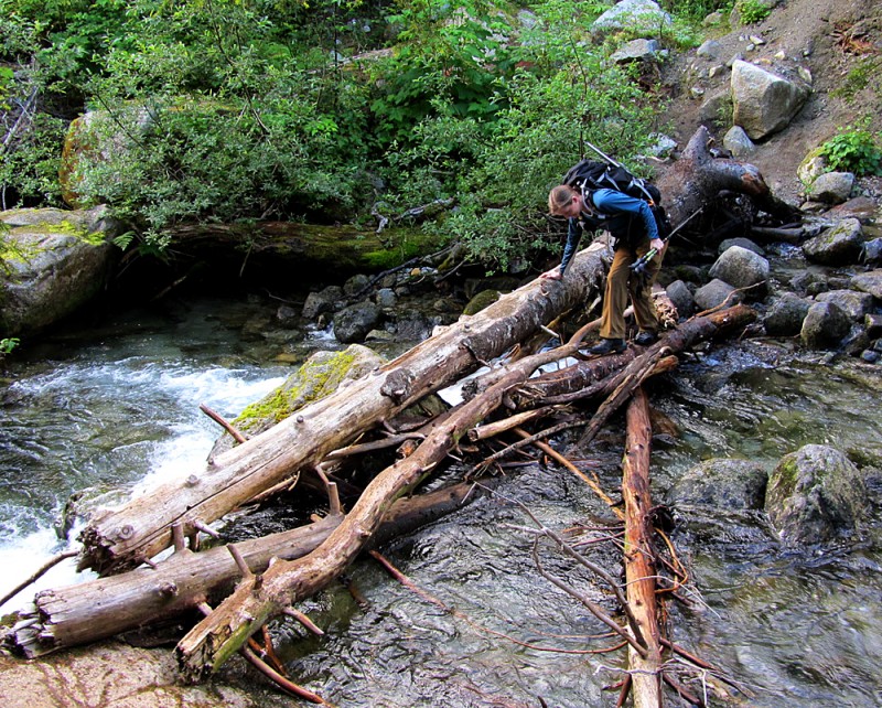
The trail starts off with a gentle grade on a decommissioned logging road. But it isn't long until it turns into a classic, Pacific Northwest trail that's covered with roots and rocks. And the occasional water crossing, of course.
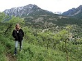
Jen crossing a stream:
Just as the trail started to steepen even more, we ran into a couple guys from British Columbia who had camped at Thornton Lakes the night before. After a short chat with them, one of the guys told us, "This is where the grinders start."
Were there going to be delicious sandwiches on this trail? I wondered.
The term "grinders" was not in my mountain vernacular, but as my wife and I huffed and puffed up the trail, we figured it meant a steep section of switchbacks. As in, "it's a real grind." Correct me if I'm wrong, though.
Regardless, it gave us a good laugh, and it reminded us of the first time we heard the term "ducks" while hiking in Glacier National Park many years ago. Some Canadian guy was describing a route to us, and he said, "When you see the ducks, take a left." I walked away thinking he was a whack job. (We later learned that ducks = cairns.)
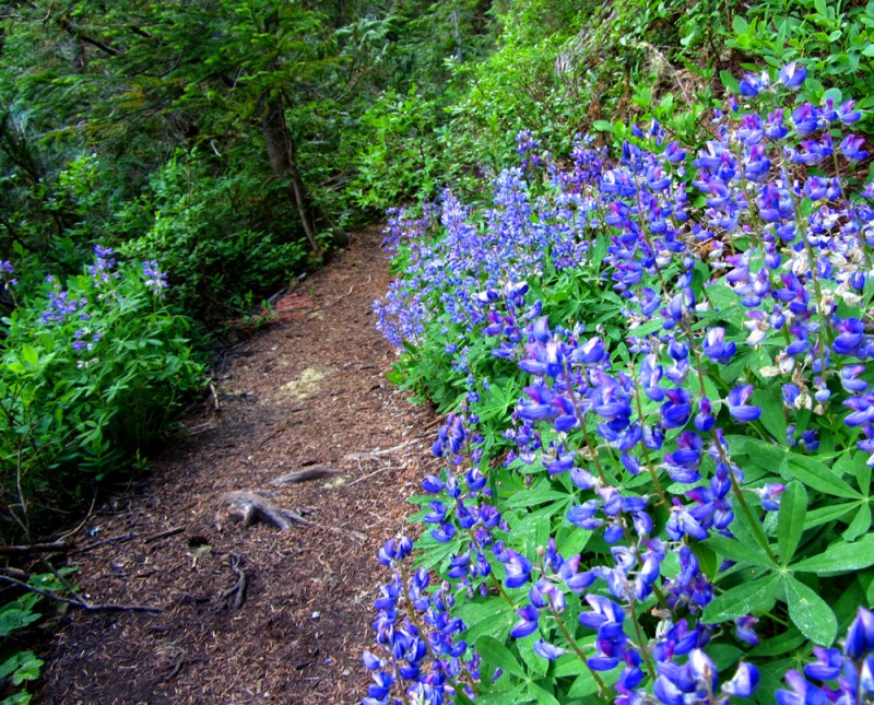
As we pushed up the mountainside toward the pass, the views started to open up.
Trailside lupine in full bloom:
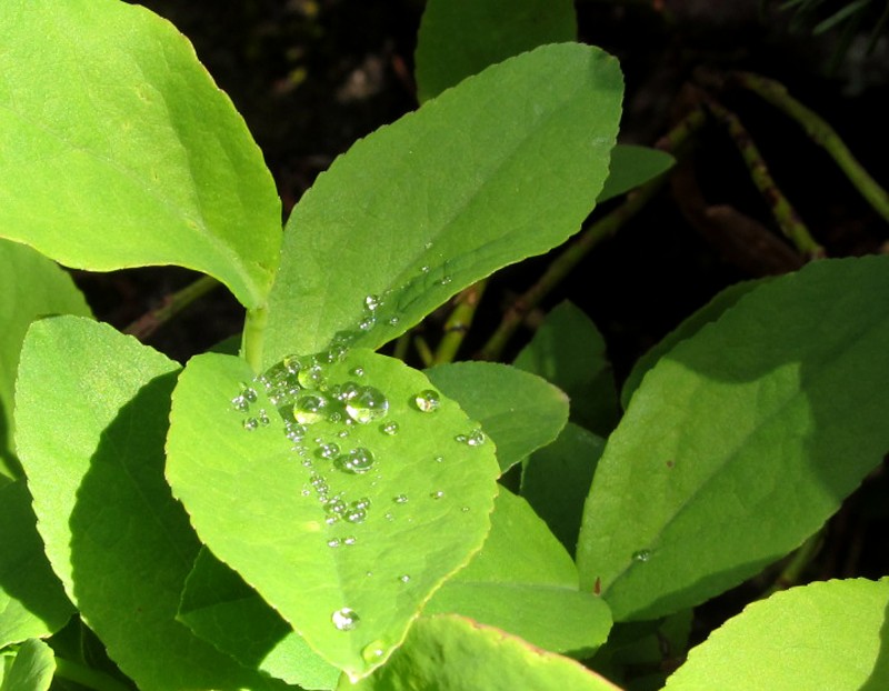
Sometimes the best views in the mountains are up close:
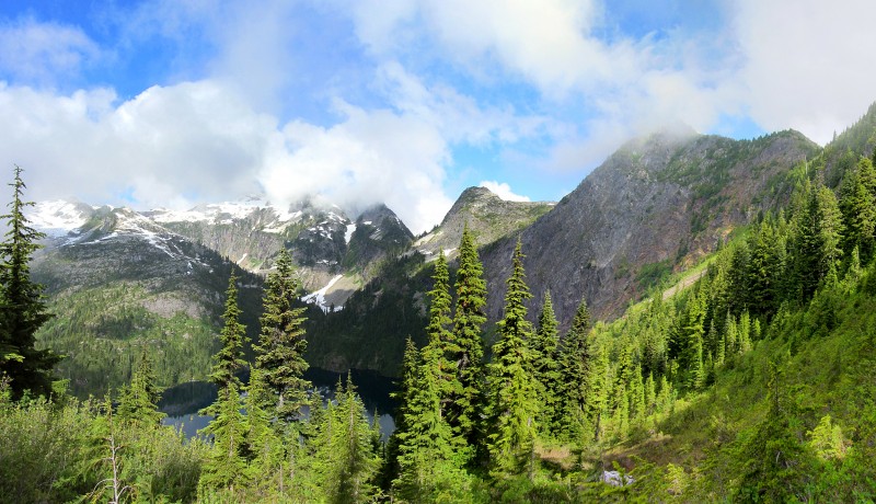
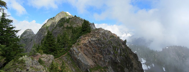
Once we gained the saddle, I was blown away by the view of the Thornton Lakes, the slabby cirques across the way, and the formidable-looking Trappers Peak. Its nearly vertical southwest face shoots up about 1,400 feet above the lake, and just looking at it made my palms sweat. The swirling clouds made it seem even more menacing. But it was still beautiful.
Here's a three-photo pan of Thornton Lakes, Mount Triumph and Trappers Peak, viewed from the saddle:
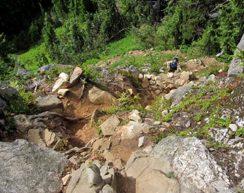
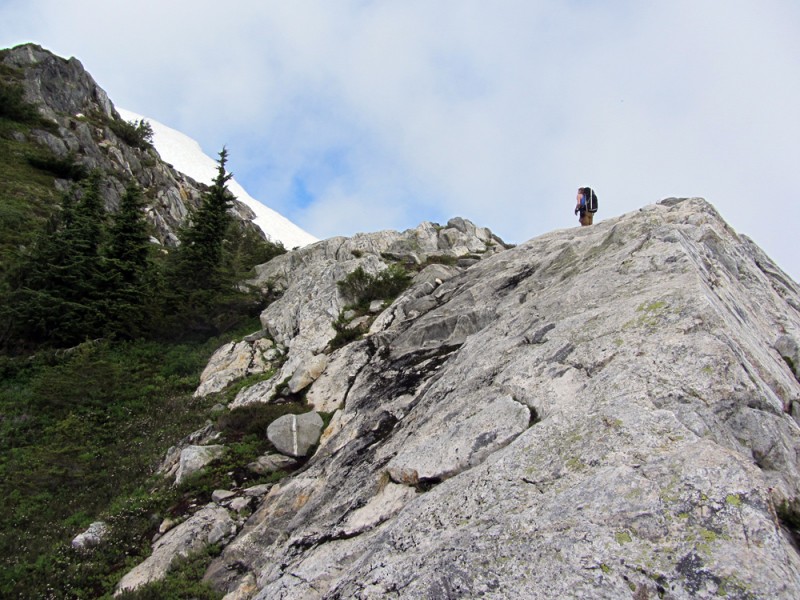
I expected to encounter some scrambling, but I was surprised by the Class 2 dirt scramble we had to endure through a thicket of bushes. Fortunately, it wasn't long before we got to real rock. Some of it was loose, though, so we had to climb cautiously so as not to kick rocks on each other.
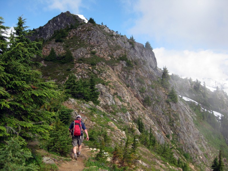
Here's Jen starting up the first steep section:
For the most part, there was a good trail (or braided trails) to follow, but whenever it became unclear, we just stayed high on the ridge.
I'm just fine on exposed, solid rock, but I'm not the biggest fan of steep dirt/grass trails that are right above cliffs. There were a couple sections like this and they got my heart pumping a little, but none of it was that bad.
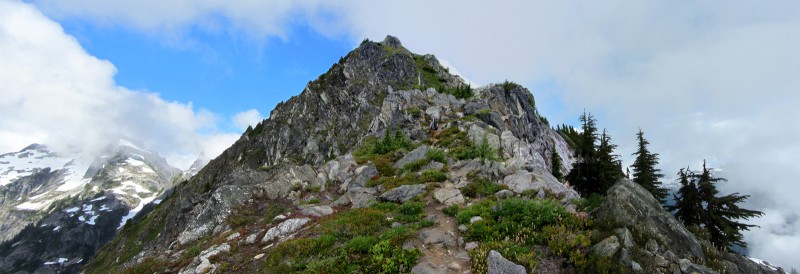
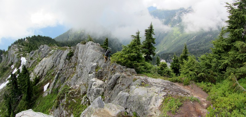
Multi-photo pan of the route before us:
The trail got a little narrow in some spots, but none of it was overly difficult or overly scary, so long as you watch your steps.
To our surprise, there was one airy section, which had what I'd call a "butter knife" edge. Even though it had a little exposure, the rock was totally solid and it wasn't very difficult to cross.
Pan of the final stretch to the top (Jen can be seen in the middle):
On a few occasions, the mountain appeared to be unclimbable. But each time, as we continued to hike, a doable route would slowly present itself.
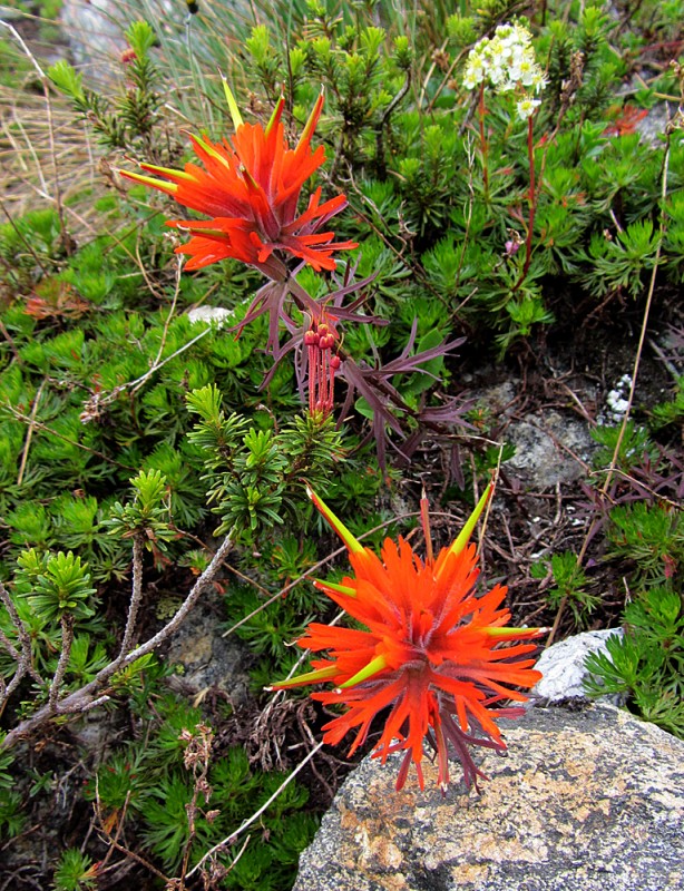
Did I mention the wildflowers were raging?
After hiking and scampering for 3 hours, we finally gained the summit. Even though it was a little cloudy, the views were spectacular. Having climbed so many mountains in so many places, it takes a lot to get me really excited. But I'll admit, I was excited on this summit.
Jen on the summit:
McMillan Spires (in the Pickets):
Me on the summit:
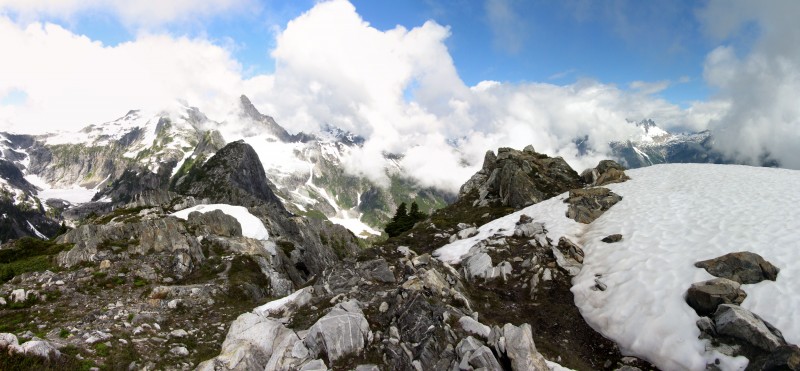
Summit-view pan (Triumph left; McMillan right):
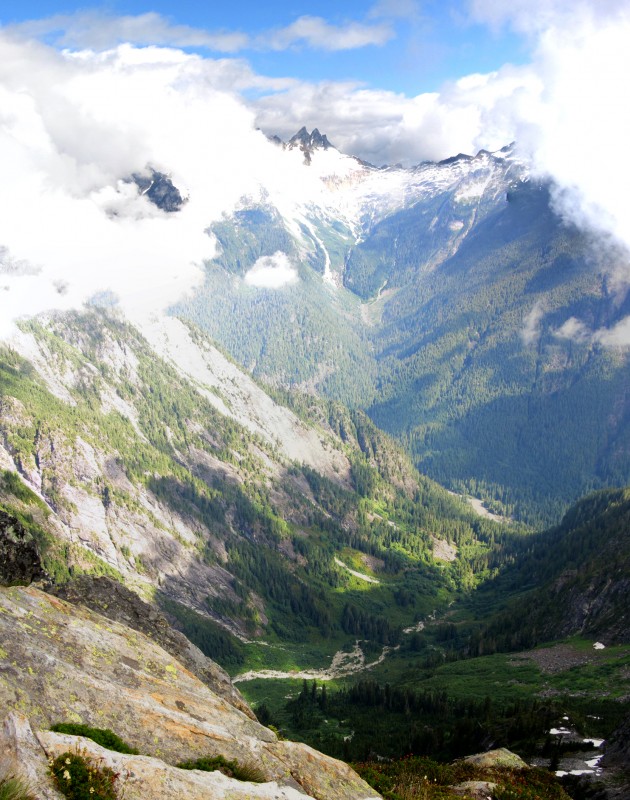
The deep valley between Trappers and the Pickets:
The view in the opposite direction was just as amazing.
Here's a zoomed-in shot of some mountains and a glacier to the south-southeast (I'm guessing Pinnacle Peak, Paul Bunyons Stump and Colonial Peak to the left and the Needle and Snowfield Peak to the right; not sure of the name of the glacier):
Another shot, zoomed back out, with Hwy 20 and Newhalem in view, which were almost 5,500 vertical feet below us:
After enjoying the summit all to ourselves for a while, we decided to cruise back down before the clouds swallowed us up.
As I mentioned earlier, I don't like steep dirt/grass trails that traverse just above cliffs, so I had to descend this section carefully:
Once back on solid rock, I was back in my comfort zone. Here are a couple shots of Jen scrambling back across the rock:
About two and a half hours later, we were back at the trailhead.
Trappers Peak was much better than I expected, but our drive to Winthrop (where we stayed for the weekend) also had some awesome views. So I thought I'd throw in some photos from the rest of our day ...
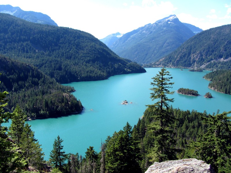
Diablo Lake:
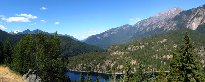
Slivers of Ruby Arm and Ross Lake with Jack Mountain upper-right:
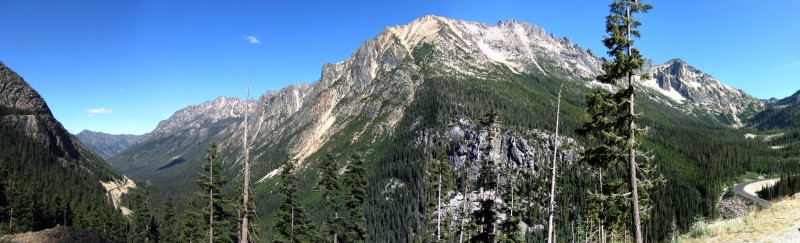
This view of Snagtooth Ridge got me so excited that I almost drove off the road:
Pan of Kangaroo Ridge off Washington Pass:
Early Winters Spires in the Liberty Bell Group:
The western town of Winthrop, WA:
View from our hotel room balcony:
And no hike/climb day is complete without beer!
Thumbnails for uploaded photos (click to open slideshow):
Man, Aubrey, your trip reports are missed around here (well, you and Jen, too!). I can't believe it's been a year...
You captured the beauty around you so well--both large and small scale. Thanks mucho for posting!
Those pics and report are amazing! Definately opened my eyes to that region of the country. I have to see Diablo Lake for myself now. Thanks for the report. :)
Love the North Cascades. Nice to see you getting out in that area ... look forward to more trip reports. And, that's a pretty d*mn good looking trail for that area ... heck, even having a ”trail” is nice. Let the 'schwacking begin. :wink: Thanks for posting. Happy ”trails”. :D
...that's what your trip reports are to me. I always drop everything when one pops up because I know it'll be a worthwhile read and a glimpse of something really different.
The PNW peaks seem so diverse in terms of the scenery you encounter along the routes. All that lush greenery down below, only to emerge into glaciated alpine. Great report and photos!
Thanks everyone for the kind words. I have to admit, I wasn't expecting much after moving up here, but I've been completely blown away by how remote and rugged it is. Most big mountains up here may only top out around 6-10k, but they more than make up for it with prominence and vertical relief (for example, being 5,500' directly above that valley on just a 6,000-foot mtn), and they're just as challenging as anything I've climbed before, if not more. Truly humbling. I'll be posting more ...
Presto, so true, and I can't believe we're STILL encountering snow at just 5,000 feet. And we spent all spring hiking off trail in snow just to get to ridges and summits. Needless to say, I've been honing my ”schwacking” and routefinding skills. The other challenge is just finding the damn trailheads! One guidebook I have dedicated an entire page on getting to the trailhead, and the route description was just two vague sentences.
Lived outside Seattle from 1990-1997 and know well the delight you are experiencing. The Cascades, North Cascades, and Olympic ranges do not take a back seat to any other range. When you are making plans for next summer, you and Jen should spend some extended time exploring the Enchantments in the North Cascades. It is everything and more that the name denotes. Thanks for posting reports that bring back great memories.
Is it just me or does image #27 look eerily like Crestone Peak and Needle? North Cascades are absolutely beautiful! Thanks for posting.
Caution: The information contained in this report may not be accurate and should not be the only resource used in preparation for your climb. Failure to have the necessary experience, physical conditioning, supplies or equipment can result in injury or death. 14ers.com and the author(s) of this report provide no warranties, either express or implied, that the information provided is accurate or reliable. By using the information provided, you agree to indemnify and hold harmless 14ers.com and the report author(s) with respect to any claims and demands against them, including any attorney fees and expenses. Please read the 14ers.com Safety and Disclaimer pages for more information.
Please respect private property: 14ers.com supports the rights of private landowners to determine how and by whom their land will be used. In Colorado, it is your responsibility to determine if land is private and to obtain the appropriate permission before entering the property.