Download Agreement, Release, and Acknowledgement of Risk:
You (the person requesting this file download) fully understand mountain climbing ("Activity") involves risks and dangers of serious bodily injury, including permanent disability, paralysis, and death ("Risks") and you fully accept and assume all such risks and all responsibility for losses, costs, and damages you incur as a result of your participation in this Activity.
You acknowledge that information in the file you have chosen to download may not be accurate and may contain errors. You agree to assume all risks when using this information and agree to release and discharge 14ers.com, 14ers Inc. and the author(s) of such information (collectively, the "Released Parties").
You hereby discharge the Released Parties from all damages, actions, claims and liabilities of any nature, specifically including, but not limited to, damages, actions, claims and liabilities arising from or related to the negligence of the Released Parties. You further agree to indemnify, hold harmless and defend 14ers.com, 14ers Inc. and each of the other Released Parties from and against any loss, damage, liability and expense, including costs and attorney fees, incurred by 14ers.com, 14ers Inc. or any of the other Released Parties as a result of you using information provided on the 14ers.com or 14ers Inc. websites.
You have read this agreement, fully understand its terms and intend it to be a complete and unconditional release of all liability to the greatest extent allowed by law and agree that if any portion of this agreement is held to be invalid the balance, notwithstanding, shall continue in full force and effect.
By clicking "OK" you agree to these terms. If you DO NOT agree, click "Cancel"...
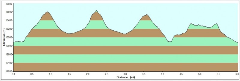
Date: Sunday, September 11, 2011 Route: Mt. Spalding's East Ridge to SE Face of Gray Wolf Mtn. > SW Ridge to Mt. Warren from Summit Lake Stats: 6 miles; 2,300' climbed; 4 hrs 10 min RT
Topo and profile of the route:
I had to be back in town in time for the University of Colorado Women's Alumni Soccer Game so I was looking for something short and quick; Gray Wolf, Warren, and Rogers fit that bill. I left Boulder at 5:30am and arrived at Summit Lake at 7:00am. Twenty minutes later I set off along Mt. Spalding's standard East Ridge. The temps were definitely chilly - fall is in the air! I left the ridge near 13,560' and headed north towards Gray Wolf Mtn., losing about 500' of elevation.
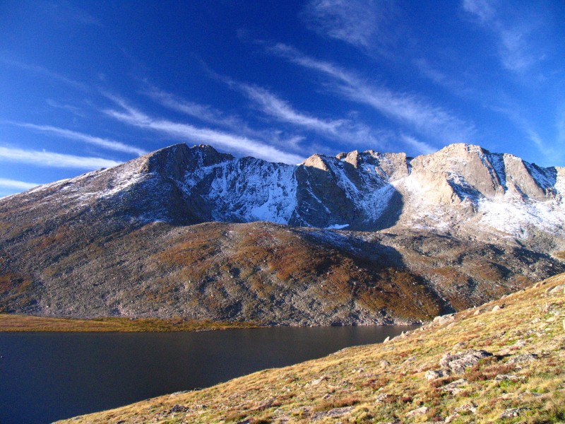
To my left, I am greeted with Mt. Evans' beautiful North Face:
To my right, Gray Wolf Mtn. comes into view from Mt. Spalding's East Ridge:
The remaining straight-forward route to Gray Wolf:
Looking back at my route from Mt. Spalding's East Ridge:
I was on the summit at 8:35am. It was 9/11/11 and I had the summit to myself. I had time to reflect on where I was that day 10 years ago, pray for all those involved and affected by the incident, and let myself be engulfed by my angel mother. A woman hiker behind me caught me in mid-prayer and didn't want to interrupt, but snapped a photo and later emailed it to me (thank you!).
Grays and Torreys from the summit:
I packed up and left Gray Wolf at 9:00am taking the same route I came; staying closer the "cliffs" to avoid re-gaining any unnecessary elevation. I reached Summit Lake at 10:20am and immediately left the trail heading east Mt. Warren's Southwest Ridge. Shortly after, I arrived on the summit at 10:45am. I did not find a trail, but it's very easy class 1+/2.
Mt. Warren and Rogers Pk from Mt. Spalding's ridge:
A shot at the route to Warren:
I started over to Rogers; before I started descending to the saddle, I evaluated the weather and time. Clouds were moving in, and it was almost 11:00am. The alumni game was at 1:00pm. It was very tempting to "just run over and tag it", but I didn't want to risk anything. I turned around and headed back to the car. I even thought about driving down the road, finding a pull-over to park, and climbing the 500' to the summit, but again, time was a factor.
The route to Rogers Peak from Warren if I had the time to go:
In a half hour, I arrived back to the car. Rogers Peak - I will be back for you! Nice day in the mountains.
My GPS Tracks on Google Maps (made from a .GPX file upload):
Last November I attempted Gray Wolf from Echo Lake. There was lots of deadfall which made the route a poor choice. Your route looks much more enjoyable! :) Beautiful conditions as captured well in your photos.
I had considered this route a year ago, and came close to completing it, but started late and ran out of time. Beautiful coarse-textured granites on Spalding. I have a shot or two of these if interested. Trip report very will done and informative.
Yes, I'd love to see the pics! Thanks for the comments Mark!
Caution: The information contained in this report may not be accurate and should not be the only resource used in preparation for your climb. Failure to have the necessary experience, physical conditioning, supplies or equipment can result in injury or death. 14ers.com and the author(s) of this report provide no warranties, either express or implied, that the information provided is accurate or reliable. By using the information provided, you agree to indemnify and hold harmless 14ers.com and the report author(s) with respect to any claims and demands against them, including any attorney fees and expenses. Please read the 14ers.com Safety and Disclaimer pages for more information.
Please respect private property: 14ers.com supports the rights of private landowners to determine how and by whom their land will be used. In Colorado, it is your responsibility to determine if land is private and to obtain the appropriate permission before entering the property.


")
")
")
")
")
")
")
")
")
")