Download Agreement, Release, and Acknowledgement of Risk:
You (the person requesting this file download) fully understand mountain climbing ("Activity") involves risks and dangers of serious bodily injury, including permanent disability, paralysis, and death ("Risks") and you fully accept and assume all such risks and all responsibility for losses, costs, and damages you incur as a result of your participation in this Activity.
You acknowledge that information in the file you have chosen to download may not be accurate and may contain errors. You agree to assume all risks when using this information and agree to release and discharge 14ers.com, 14ers Inc. and the author(s) of such information (collectively, the "Released Parties").
You hereby discharge the Released Parties from all damages, actions, claims and liabilities of any nature, specifically including, but not limited to, damages, actions, claims and liabilities arising from or related to the negligence of the Released Parties. You further agree to indemnify, hold harmless and defend 14ers.com, 14ers Inc. and each of the other Released Parties from and against any loss, damage, liability and expense, including costs and attorney fees, incurred by 14ers.com, 14ers Inc. or any of the other Released Parties as a result of you using information provided on the 14ers.com or 14ers Inc. websites.
You have read this agreement, fully understand its terms and intend it to be a complete and unconditional release of all liability to the greatest extent allowed by law and agree that if any portion of this agreement is held to be invalid the balance, notwithstanding, shall continue in full force and effect.
By clicking "OK" you agree to these terms. If you DO NOT agree, click "Cancel"...
These 13ers are rarely climbed together, which on its face, would seem odd since they are surrounded by very popular 14ers (Wilson Peak, Mount Wilson, El Diente) and a high centennial (Gladstone). We originally got the idea to do the traverse of these three peaks from Papillon and Wooderson. Their initial thoughts, and ours, were that these would be an "easy" day.
Upon trying to find information about the route and the peaks, it became apparent that combining these three in a traverse would offer us everything we were looking for in an adventurous full day, and then some. Mike Garratt had done the traverse from lowest to highest and "didn't recommend it". Teresa Gergen had done the traverse from highest to lowest and called it "long" and "non-trivial". Another comment attributed to her was "that traverse was the scariest thing she did without a rope on a 13er". Well, that settled it ... we would bring the rope. Wow, amazingly, I still wasn't feeling much love after adding that piece of equipment to our packs.
We arrived at the Woods Lake trailhead parking area on Thursday late afternoon. It was hot in the parking area, so we sought out shade from the trees waiting for it to cool down a bit and consumed our supply of Dale's ... the motivating juice force of nature. After running out of beer, we had no more excuses to hang around, so we shouldered our packs and headed up the well-defined Woods Lake trail. After about 2-1/2 miles (and about 50 yards before the Elk Creek Junction), we found a secluded and grassy campsite and pitched the tent. What an ideal location! There was a creek from a mountain spring nearby and someone had constructed the perfect food hanging contraption between two trees near us ... all we had to do was toss the rock and hang the food. Nice!
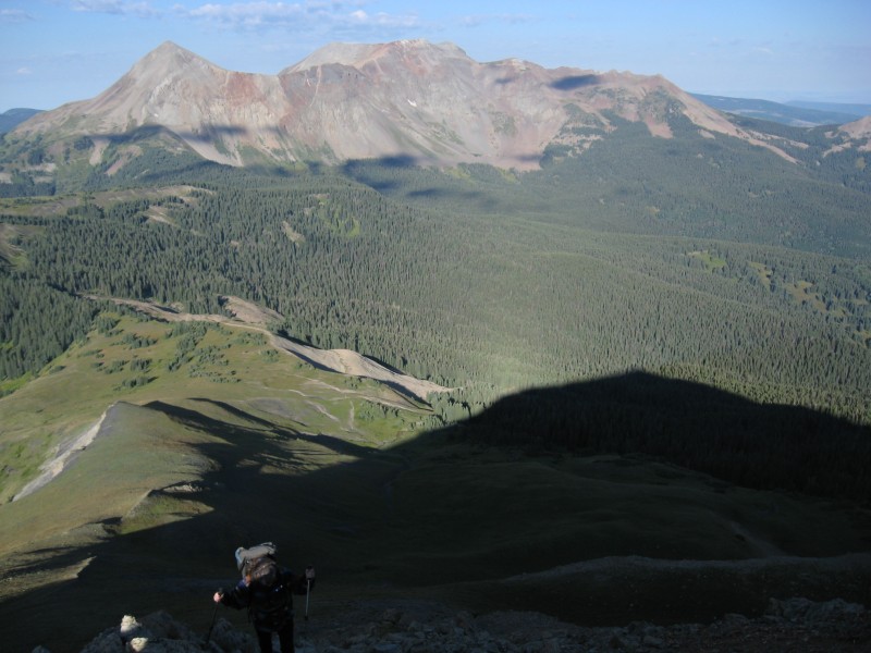
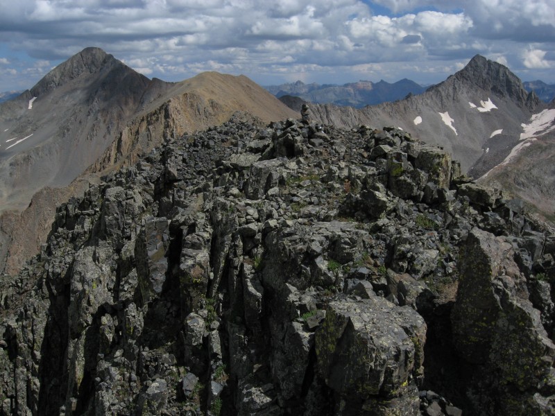
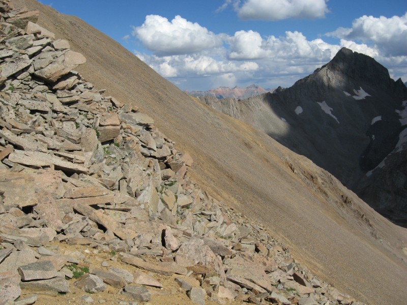
Friday morning brought beautiful weather, though breezy, and we headed up the Woods Lake trail to eventually intersect the ridge coming down off of Unnamed 13,123. Gentle slopes, with breathtaking views of El Diente, led us to our first summit of the day and views of things to come. And, what views they were ... not very inviting to say the least. We could see some of the vagaries of the ridge and knew that they would begin very soon as we descended the ridge to the saddle between Unnamed 13,123 and Unnamed 13,498. We signed into the register and were on our way ... there were quite a few signatures as quite a few people climb this peak by itself from the Woods Lake trail. Ascending Unnamed 13,123 with Dolores and Middle Mountain in the Background
Just a personal note here ... we're big believers on staying as high as possible on ridge traverses ... being on top generally gives you the most stable footing, and the best views of where you need to go next. The first views of Unnamed 13,498
We soon came to the first obstacle ... a large notch that sat in the saddle. There was mention, in some beta that we received, that you could negotiate this notch with much exposure and some 5th class action. We opted to bypass this by going slightly to our right, descending a crappy and exposed gully down to a broad couloir, regaining the elevation to the saddle and ascending back up to the ridge. Once on top of this ridge, we stayed high and made our way towards Unnamed 13,498. Looking back at Unnamed 13,123
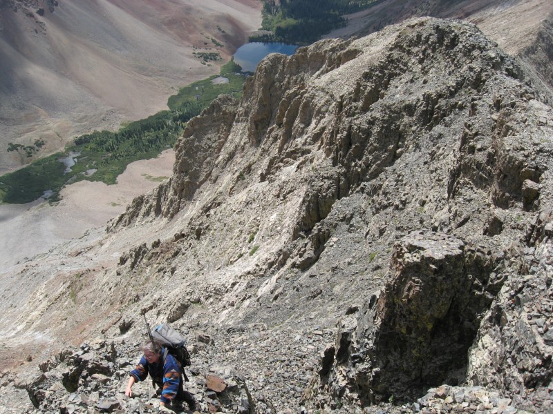
The views from here were discouraging. It was apparent that we would indeed, as beta had suggested, have to lose some elevation (around 300 feet from the ridge we were on) in order to get around some large subsidiary ridge points that blocked better access to the summit ridge. That contouring descent was via some loose talus and scree and packed dirt and took more time than we thought. Eventually, we had made our way around the obstacles and began climbing up broad gully on a variety of ledges and slabs all covered with loose rock (it reminded me just a bit of the "early" Bells routes before they got cleaned out by all the traffic). Making our way up Unnamed 13,498
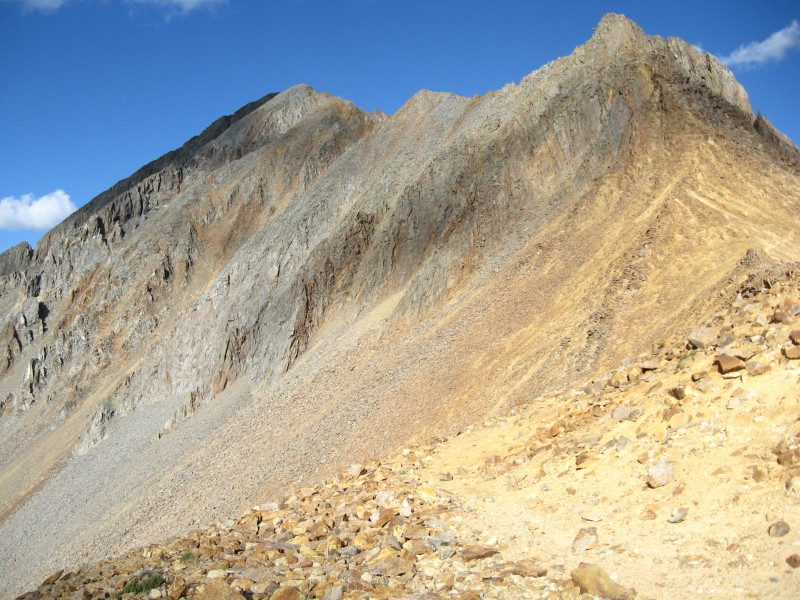
We headed up the very broad gully, trying to pick the best route. We attempted to intersect the ridge leading to the summit at this point, but came to a dead end. Instead, we ascended some more and then crossed over a rock rib to our right through a notch into the next broad gully that had ledges and slabs all covered with loose rock. We continued up ... but, this time when we tried to exit to our left high up, we were able to intersect the ridge. You know, I was really looking forward to that ridge thinking it would make me feel a bit more secure than the broad gully ... silly me. We were about 250 yards from the summit at the time and followed a very exposed and loose ridge (staying on top was best) to the summit ... at times, it made the "sidewalk in the sky" look like a freeway. The summit cairn on Unnamed 13,498
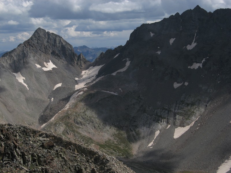
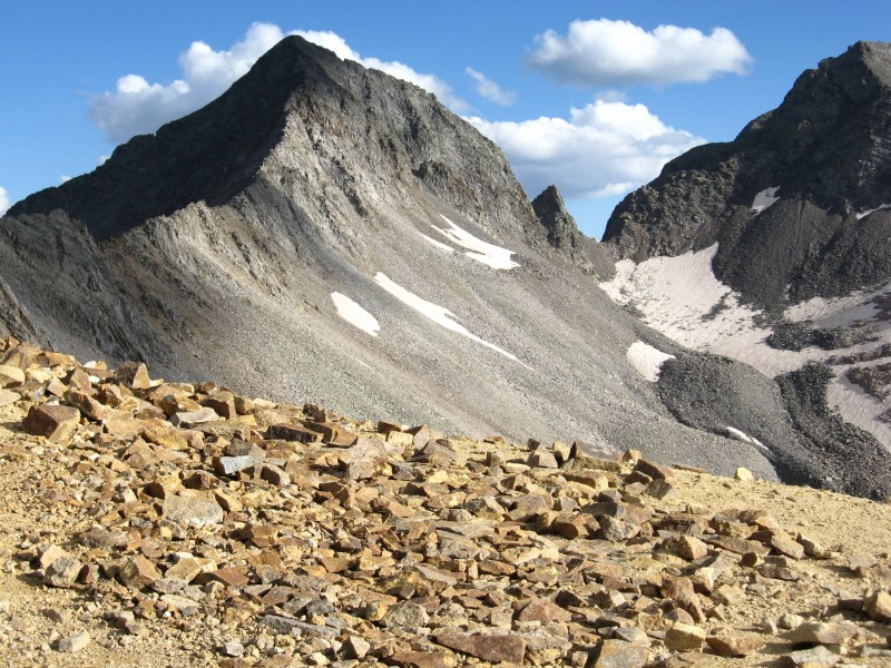
We reached the summit of Unnamed 13,498 and took our first really good break. I'd been battling a bit of mountain sickness that morning (it can happen to everyone), and so I forced myself to eat some food and drink a bunch of water. The views from the summit were fantastic ... we had been so busy concentrating on the task at hand that we really hadn't looked around very much. The Wilson/El Diente traverse was laid out in front of us, Dolores and Middle Mountain were nearby, some of the peaks around Yankee Boy Basin, Gladstone, and also the Pilot Knob and Vermillion group. The weather was great. We signed into the register ... it'd been there since August of 2010 and only had 12 signatures in it. Not surprisingly, quite a few "peakbaggers" ... two people who signed in only had 4 of the 13,000+ peaks to go; and, two other people had 6 of the 13,000+ peaks to go. We saw SarahT and Dsunwall, and the Roach's. We added our names. Someone had written "School Bus Peak" in the register. Hmmm. Somehow, I associate a school bus with something of comfort and safety ... NOT this peak really ... but, we would soon "see" what that reference was all about. View of the Grenadiers between Gladstone and Mt. Wilson
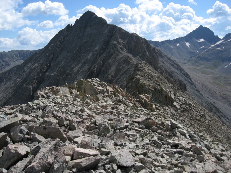
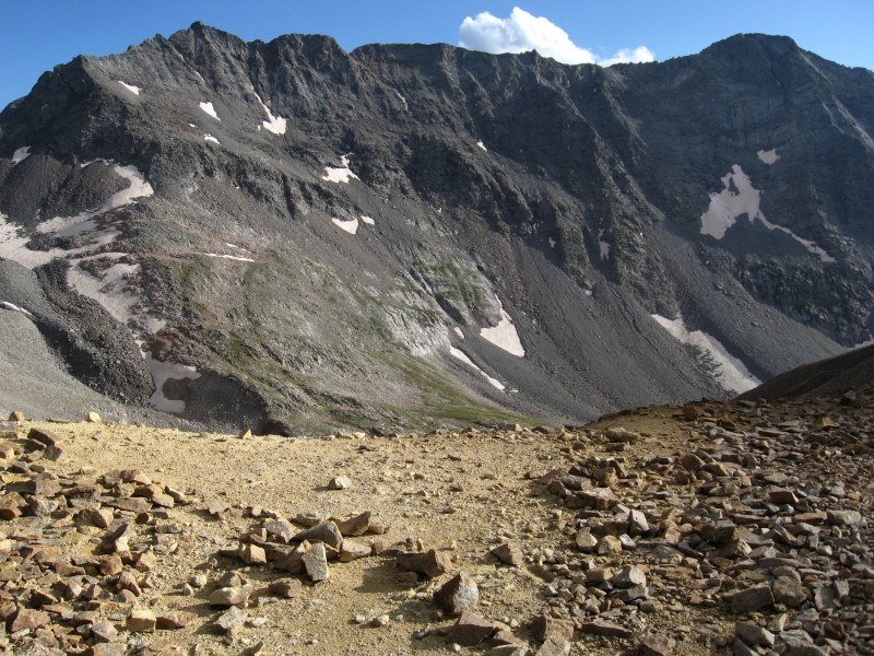
We knew, from the beta, that we still had another obstacle to go. The view of Unnamed 13,540 was enticing as we descended the loose and exposed ridge down to the next saddle. We soon came to the "chockstone" that was discussed in the beta and negotiated that without the aid of a rope (by taking off our packs, having one of us go, handing down the packs, and having the other one go). There were gullies nearby, but the run out was poor and everything was loose. It was best to just stay on top of the ridge as much as possible. We did use the rope shortly after that for a handline ... just a bit too short to reach a move (and, in a place where you really didn't want to slip or you'd hurt yourself) ... maybe if it were at the beginning of the day and we were both fresh. But, heck, we'd hauled the d*mn rope all day ... might as well use it if only for a minute or two. Descending off of Unnamed 13,498
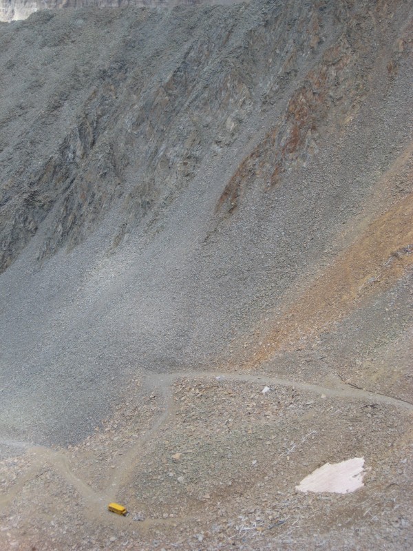
As we continued down to the saddle, we looked down to our left and were enlightened as to the "school bus" comment in the register. Down in the bottom of the basin, there sat an old school bus. How the heck it got there, I'll never know. Maybe some Telluride local can fill us all in on that little story. View of the "school bus"
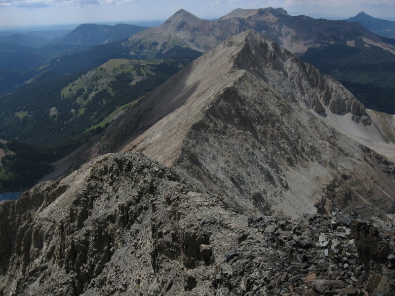
Looking back up at Unnamed 13,498 was amazing and terrifying at the same time. It was hard to see where there was a route in all of that mess (it kind of looked like Pyramid does when you finally get that final view after you come around that corner on the ridge). But, everything from here down was supposed to just be typical terrain for the area ... talus and scree ... and some of it moves. Unnamed 13,498 Gladstone on the way up 13,540 Pilot Knob, Golden Horn, Vermillion
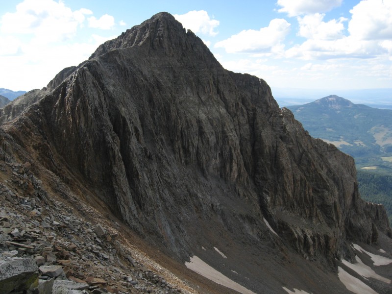
Ahhh ... Unnamed 13,540 ... how nice it was to hit your summit. The views of Wilson Peak, Gladstone, Lizard Head, the Ice Lake Basin group, etc. WOW! The poor register needs to be replaced ... it was very damp and unsignable ... it's been up there since 2004 (and has many signatures). We ate some more, drank a bunch of water and picked our way down to the Rock of Ages saddle. It was so nice to be on flat ground ... and no moving rocks ... all day with the moving rocks (small and large) ... it wears on your psyche after awhile. Gladstone from the Rock of Ages Saddle Wilson Peak from the Rock of Ages Saddle Mt. Wilson, the Traverse, El Diente Ridge of Wilson Peak from the Rock of Ages Saddle
We followed the trail down to Navajo Lake (a crowded place, I might add), took the Woods Lake trail junction up and over and back down to our campsite where we crashed ... satisfied with our efforts of the day. We had planned on doing Dolores and Middle the next day; but, instead decided to sleep in. We backpacked out, stopped by The Colorado Boy and had beer (yummy IPA) and pizza (yummy pizza). Life is good.
The name of this trip report was actually inspired by the three mountains ... Eenie (Unnamed 13,123) was the smallest of the three, Meaney (Unnamed 13,498 ) was indeed a formidable foe, and Miney (Unnamed 13,540) was the peak that had the most mining activity visible on it.
I would like to give a special thanks to Kansas and Furthermore for providing beta about these peaks. The information and photos were very helpful.
If I could give any advice on this traverse, it would be the following: small experienced parties only that are comfortable on continually loose terrain, some exposure, are good at route finding (there is not one cairn on this entire ridge and we kept it that way), and have good weather all day (which we did). Personally, I think doing the traverse in the direction we did was making the best of a challenging route finding situation. I can honestly say (and my hubby agrees) that we will not be repeating this route (and we're darned glad it's done). 8)
Happy trails!
Thumbnails for uploaded photos (click to open slideshow):
I'm stoked that you posted a TR for everyone with solid beta, new peak names, and gorgeous views galore.
It's too bad Chris Farley's ghost wasn't there on ”School Bus Peak.” http://www.youtube.com/watch?v=07c07pNLqig
Was the old romano cheese can register still on ”Eeenie?”
Let's get the Vulgarians together soon.
If you like that sort of thing... Thanks so much for posting. Great to see a trip report from you and on one on some very rarely travelled peaks to boot. Thanks again.
Wondering why that was never the standard approach (maybe to keep the gapers away). Gotta love that spire between Gladstone and Mt.Wilson, looks like one hell of a traverse. Now this is a worthy Wilson Massif read, good stuff Presto.
I've seen some solid ski lines off of some of these peaks, good to know the views aren't too shabby either.
Great descriptives and beautiful photos! Those look like a lot of fun, but I have to get my kids a little more up to speed and a little older to try something like that. The start was nice, the Dale's is a good way to take the edge off before a night sleeping on the ground, followed aggressively by climbing mountains.
Matt - Nope, that romano cheese holder was not there. :( Yup, the Vulgarians need a gathering sometime this month. 8)
Furthermore - I look forward to your trip report of this traverse in the future. :wink:
Kansas - Very true, my friend. There's been some real quality (obscure) posts by great contributors to this website this season. I'm not worthy.
Mtgirl - I wish someone would give some background on that darned bus. :)
Floyd - :lol: Yeah, well, I don't really like that sort of thing, but you play the hand you're dealt.
Mtnhub - :oops: Thanks!
Mennoguy - Glad I could help ... look forward to your trip report!
Lordhelmut - Ah, yes ... I've heard that traverse between Gladstone and Mt. Wilson is a sphincter-clincher for sure. Looking forward to your ski climb trip reports very much. :D
Jpfeif001 - Loved that report with your daughter on Longs ... may I have some more please? :wink:
Benners - :lol: Your guess is as good as mine on that bus. Thanks for reading!
As Lincoln supposedly said, ”If this is the kind of thing you like, you'll like this kind of thing.” Hours of traversing loose ridges aren't everybody's cup of tea, but it makes for a good TR. Great peak names, too!
And somehow I missed your previous one. (I guess that's when I was out in CO doing some of my trails!) But great read with great pics! Thanks, Terri!! Let's see some more! :D
Everything in the San Juans sounds effortless and obtainable when you're sitting in Denver. I believe you told me once before that the best laid climbing plans are hatched in bars with pints and friends and paper napkins that morph into crudely sketched topos. Way to lock into these peaks and deliver. I look forward to hearing more about it.
Maybe I can shed some light on the School Bus. In 1993, it was being used as a shelter by some old miner that was still getting gold out of a mine in that basin. I ran into him when he was driving down the Silver Pick road with a pickup pulling a trailer with a fairly small, but heavy, box chained on top of it.
Gosh, DaveLanders, I appreciate someone finally shedding some light on that mystery ... not exactly the place you expect to see a bus.
Caution: The information contained in this report may not be accurate and should not be the only resource used in preparation for your climb. Failure to have the necessary experience, physical conditioning, supplies or equipment can result in injury or death. 14ers.com and the author(s) of this report provide no warranties, either express or implied, that the information provided is accurate or reliable. By using the information provided, you agree to indemnify and hold harmless 14ers.com and the report author(s) with respect to any claims and demands against them, including any attorney fees and expenses. Please read the 14ers.com Safety and Disclaimer pages for more information.
Please respect private property: 14ers.com supports the rights of private landowners to determine how and by whom their land will be used. In Colorado, it is your responsibility to determine if land is private and to obtain the appropriate permission before entering the property.