Download Agreement, Release, and Acknowledgement of Risk:
You (the person requesting this file download) fully understand mountain climbing ("Activity") involves risks and dangers of serious bodily injury, including permanent disability, paralysis, and death ("Risks") and you fully accept and assume all such risks and all responsibility for losses, costs, and damages you incur as a result of your participation in this Activity.
You acknowledge that information in the file you have chosen to download may not be accurate and may contain errors. You agree to assume all risks when using this information and agree to release and discharge 14ers.com, 14ers Inc. and the author(s) of such information (collectively, the "Released Parties").
You hereby discharge the Released Parties from all damages, actions, claims and liabilities of any nature, specifically including, but not limited to, damages, actions, claims and liabilities arising from or related to the negligence of the Released Parties. You further agree to indemnify, hold harmless and defend 14ers.com, 14ers Inc. and each of the other Released Parties from and against any loss, damage, liability and expense, including costs and attorney fees, incurred by 14ers.com, 14ers Inc. or any of the other Released Parties as a result of you using information provided on the 14ers.com or 14ers Inc. websites.
You have read this agreement, fully understand its terms and intend it to be a complete and unconditional release of all liability to the greatest extent allowed by law and agree that if any portion of this agreement is held to be invalid the balance, notwithstanding, shall continue in full force and effect.
By clicking "OK" you agree to these terms. If you DO NOT agree, click "Cancel"...
Little Bear peak is a name that conjures up images of a bunny slope at the local ski area. Maybe the 14,000 foot mountain in the Sangre de Cristo range needs to be renamed something more descriptive, like Satan's playground or Rasputin's revenge.
I first heard talk of this peak through a longtime friend of mine last December. I ran into Jordan on a job I was working on and he mentioned that he was real close to completing climbs of all 56 of the states 14ers. I was interested because I've been climbing them too and he thought he might finish with Little Bear. I asked him what list he was looking at that had 56 peaks and he said the "Nalgene list". Of course I had to smile and ask 'What's the Nalgene list?" His reply: "The list that's on my Nalgene bottle." Sounds good enough to me!
We've been in touch on and off all summer and I finally got the call that it's time to go. He didn't complete a few others that he needed but no matter because we were ready for this one. We wanted to do this one midweek to avoid crowds and reduce the danger that is always close by with elements of this mountain.
I have to give a bit of introduction to Jordan because he is so unique. He has lived on the back side of Aspen Mountain for over 35 years in a cabin with no running water and no electricity. He has raised two great kids up there and shuttled them on a snowmobile down the mountain to his pickup where he drove them into town everyday for school. Imagine the discipline that would take! I heard a rumor once that he snowmobiled up the back side of Aspen Mountain to the Sun deck, skied down to the Gondola Plaza, and paid for a lift ticket just so he would know what it felt like....He is in fact the most interesting man in the world!
So, on with the report. Jordan had 2 other friends, Peter and Michael, that he has climbed with frequently and we all met up at the trailhead to start the drive up the road to Como Lake. This road is infamously known as the worst jeep road in Colorado. It lived up to it's reputation. I believe the road from the trailhead to Como Lake is about 5 miles. We were able to drive up only about 1.7 miles before I was sure my pickup was going to be damaged. We pulled off into a level campsite and prepared for the next day. A nice campfire, supper and a cold beer was just the ticket. In talking around the campfire I discovered that at age 50, I was the youngest one there. This meant that I was going to be stuck with keeping the bedpans, walkers and canes working properly. But seriously, I would later find out that they were all experienced, fit, and capable for the task at hand.
We got up at 3:30 a.m. and were on the trail by 4:30. We only needed our headlamps for a short while because the waning moonlight was enough to light the trail for most of the way. The 3+ mile hike to the Lake was uneventful other than the several sections of road known as "Jaws" . Jaws 1: Notice the memorial plaque on the rockJordan walking up one of the Jaws sectionsMichael & Peter walking over one of the Jaws sections
The rocks were so big that I don't know how anything could drive over them. I would love to see the piece of equipment that makes it all the way to the lake. It was common to see
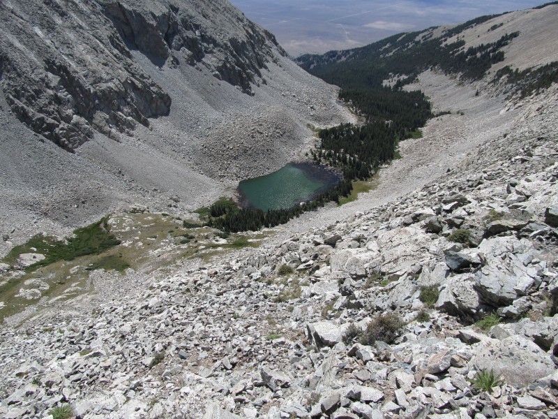
large boulders covered with oil and transmission fluid.Little Bear above Como Lake
We arrived at the lake at 7:30 and took a 25 minute break before heading up through the first gully. Taking a break before the gully climb
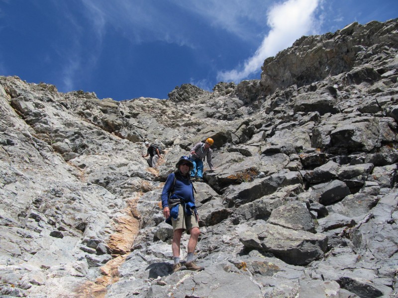
It was time to put away the trekking poles and put on the helmets. The first gully received hardly a mention in the route description that I read, so I was surprised to see how steep and loose it was. Every step seemed to collapse under our feet and it was hard to keep the rocks from taking off. Michael & Jordan in the gully
I was trying to be careful but a rock about the size of watermelon went sailing down through the gully and missed Jordan by about 8 feet.
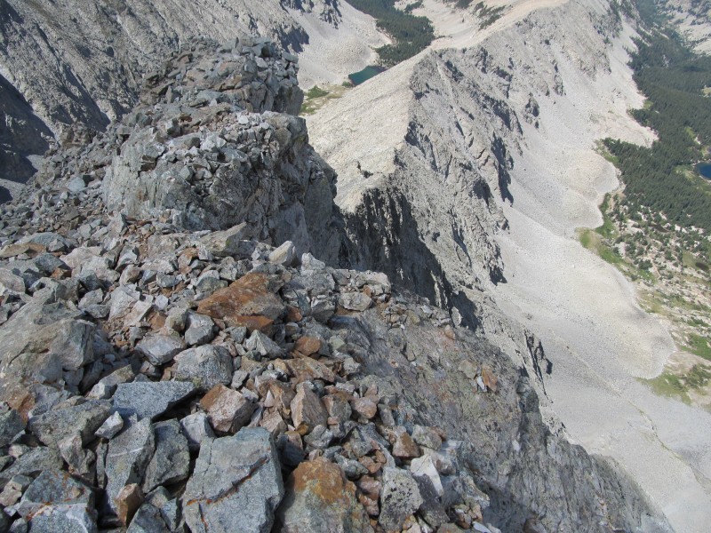
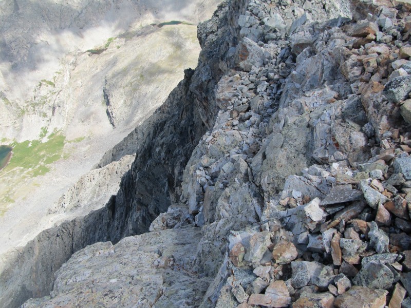
The ridgeline was a welcome site and we were glad to be out of the gully. I expected the traverse below the right side of the ridge to be easy as we crossed over to the base of the Hourglass. As usual, nothing seems to come easy on this mountain. It was quite a bit farther than I expected and not a very well defined trail. Finding cairns for guidance was sketchy. Traversing across to the Hourglass
About half way across near the notch or saddle in the ridge we met up with a couple that was descending from the summit. It was perfect timing because they told us that nobody was between them and the summit. This meant that we didn't have to worry about people above us kicking rocks down into the hourglass as we climbed up through it. They were fortunate enough to have had the same freedom. Another piece of information that was valuable was that the ropes suspended through the hourglass were solid and fairly new. We were much more confident about the climb ahead.
We arrived at the base of the hourglass at 10:05. First View of the Hourglass
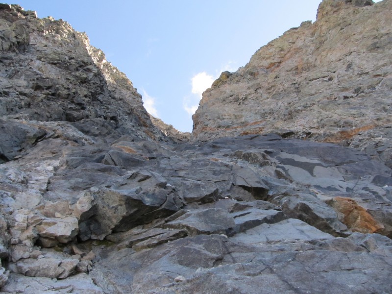
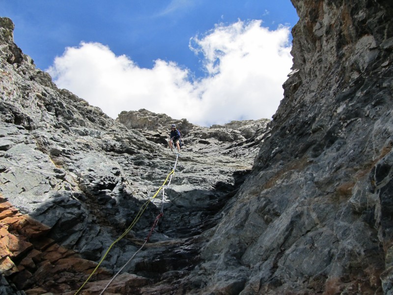
For those who don't know the hourglass is a section of smooth polished rock that ascends toward the peak at about a 45 degree angle. It usually has at least a small amount of water running through it. It is shaped like an hourglass; wide at the top, narrow in the middle, and wide at the bottom. The problem is that besides the obvious danger, the sections above it are loose rock that when kicked loose are funneled right down this gully. Many accidents and fatalities have occurred here. If Little Bear would be more appropriately named 'satan's playground, then the hourglass should be named 'The devil's crotch'.
We studied the climb ahead and Peter took the lead as we started the ascent. Peter in his happy placeJordan in the Hourglass
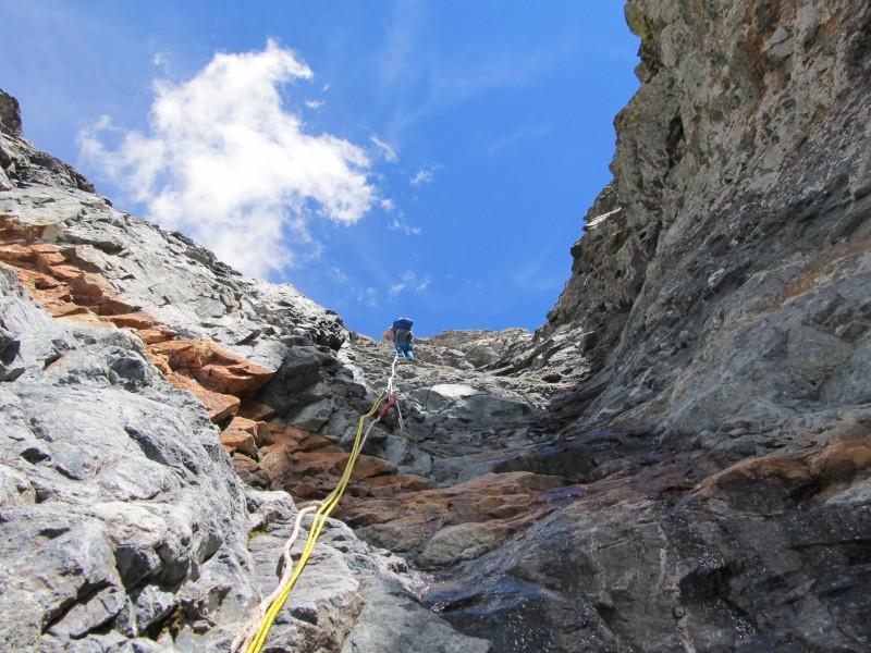
I vowed that I would not use the rope but I would stay by it in case I needed to grab it. I was bringing up the rear and part of the way up I asked Jordan if I could hand him my camera so he could take a picture of me. Note to self: Don't bother Jordan when he's gripped. Note to readers: When you're using both hands and both feet to hold on for dear life on a 45 degree bowling alley, don't even think about the Kodak moment. Let it pass!
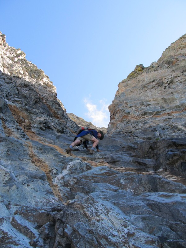
I started to slip on a wet spot about two thirds of the way up and quickly opted out of the no ropes clause. My bravery only goes so far. Looking back down the HourglassThe Anchor rock
As the terrain eased up we took a break at the top of the hourglass and studied the terrain ahead. There was no clear path to the summit and we couldn't even tell which one was the real thing. The route description from 14ers.com said to stay left so we did. Peter, Michael, & Jordan above the Hourglass on the way to the summitFinal push to the summit
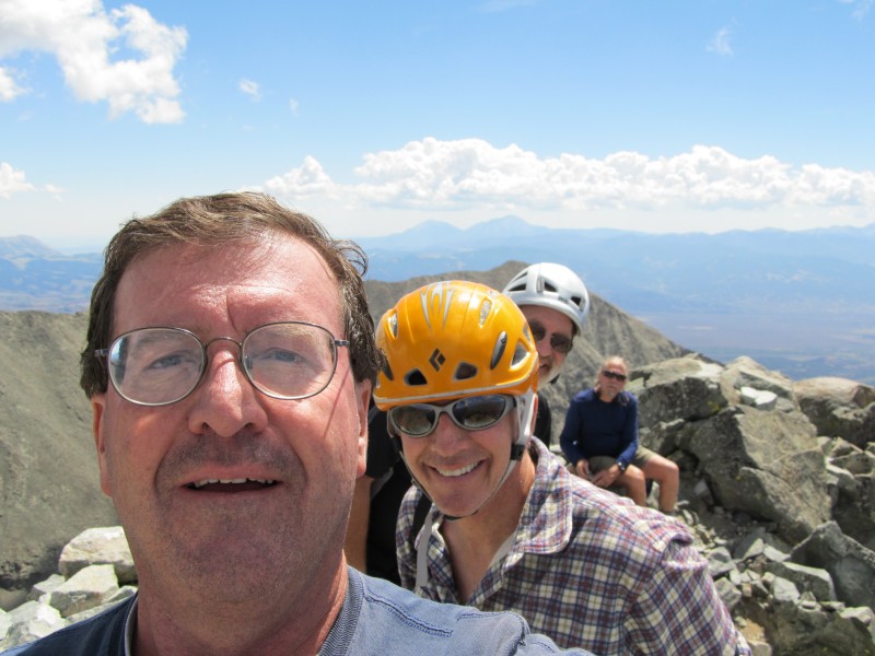
There was plenty of class 3 and 4 climbing in the last few hundred feet and we finally reached the summit at 11:05.
There is no way to describe the exhilaration of reaching the summit. The day was perfect. Perfect weather, perfect view, and great company after a hard workout. 3 14ers: Ellingwood point, Blanca, & LindseyThe Face of Little BearMe, Michael, & Jordan on the summitMe, Michael, Jordan, & Peter
After a few sketchy phone calls (cell reception is not the best on the peak) a snack and a needed rest we headed down at 11:45. Peter started singing some song about being happy or glad or something and I think he was making up the words as he went along. I started singing the closing theme song from the Carol Burnett show. It was beautiful. Or it was horrible. I can't decide, but one thing for certain was that we were in the zone. We were in that place of satisfaction, that high that keeps us coming back for more. It's a place of rarified air that has only been breathed by those who seek the mountaintop. Headed back down
Route finding on the way back down to the hourglass was no easier than on the way up. We frequently had to step out on ledges to scout the terrain ahead. One bit of advice: Stay climbers right as much as possible on the way to the hourglass. This is for safety reasons for those that might be below. If you approach the hourglass from directly above it the rocks that might be kicked loose will come close to terminal velocity by the time they go down through there. If you come into the top of the hourglass from the side the rocks might still go into the funnel but they will be much slower and give a person in there a chance to get out of the way.
So we finally reached the 'slip and slide' and there was no more debate about whether or not to use the rope.Me by the Anchor rock
The consensus at that time was "Let's get this thing over with". Several hours of scrambling and route finding changes attitudes. I took the lead this time and opted for the face first rappel. I don't know if that's what it's called but I was interested in seeing what I was going to bounce off of if the rope came loose. The HourglassPeter in a face first rappelMichael rappelingJordan rappeling
When we were all down through the hourglass it was time to breathe a sigh of relief and we took another break. The notch along the ridgeLokking back on the route to the summit
The remaining traverse across to the top of the gully, down the gully, and down the Como lake road to our pickups was uneventful. We arrived at our campsite at 6:30 p.m. for a round trip time of 14 hours. It was an honor to climb with Jordan for the first time and my 2 new found friends Michael and Peter. Until next time, Stay thirsty my friends!
Thumbnails for uploaded photos (click to open slideshow):
Ever since reading about it in the Gerry Roach book, I've planned on doing Little Bear and most of the Elks mtns after hiking the Front, Sawatch, San Juans,and other Sangres. I love the Rasputin's Revenge, btw, but maybe Little Bear is a fitting name. Think about it, what's the most dangerous bear you can cross paths with in the woods? A baby bear. Where there's lil baby bear, there's mama, ready to go whoop-ass on you. Congrats on a tough summit
in seeing what I was going to bounce off...WOW 8/27/2011 5:54am
Do us all a favor and don't trust those ropes with your life; they are a death trap from hell. And no that is not (proper) rappelling, that you hear others referring too. I am glad you and your group alive. Sounds drastic but I don't believe it is.
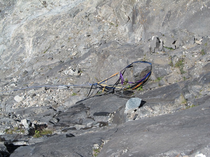
Others that don't know about those ropes in the hourglass, search the forum and learn not to trust them. When people hike the hourglass in the winter/spring, they have an ice axe and crampons. Take a guess what is being stuck into those ropes? Next problem, sun exposure and dry rot. Also why would someone leave behind a several $100 rope?...because it is near the end of its life. Then judge the anchor...etc, etc, etc, etc. Bring your own gear if you find it necessary.
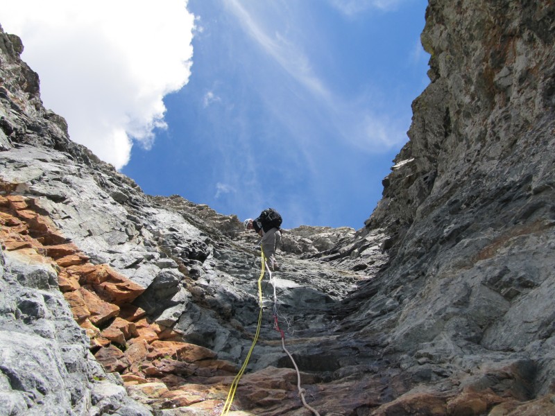
We did search the forum and were fully aware about the dangers and issues with somebody else's ropes. The ropes were safe on this occasion. As I mentioned, the group ahead of us gave us beta before we headed up but we still didn't trust them and only used them as backup. There were 3 different ropes, 2 of which were worn but the yellow one that you can see in the picture was new. Of course we examined the anchor, connections,knots,etc. When descending we only went one at a time with others watching. There is always risk but I think we eliminated as much of that as possible by taking the precautions I mentioned.
Very nice, and detailed report, and of course loved all the great photos. We'll be up there this weekend weather permitting. By the way, "the road" (Como) is actually just over 7 miles to Como Lake (off of 150), so you can tack on another 4 miles (round trip) to the distance you guys covered! I was up there last year and made it 5 miles in my SUV to 11,000', though I won't even think of trying that again. Search "Lake Como Road" in Google for video of vehicles that do make it all the way up.
Caution: The information contained in this report may not be accurate and should not be the only resource used in preparation for your climb. Failure to have the necessary experience, physical conditioning, supplies or equipment can result in injury or death. 14ers.com and the author(s) of this report provide no warranties, either express or implied, that the information provided is accurate or reliable. By using the information provided, you agree to indemnify and hold harmless 14ers.com and the report author(s) with respect to any claims and demands against them, including any attorney fees and expenses. Please read the 14ers.com Safety and Disclaimer pages for more information.
Please respect private property: 14ers.com supports the rights of private landowners to determine how and by whom their land will be used. In Colorado, it is your responsibility to determine if land is private and to obtain the appropriate permission before entering the property.


 Little Bear Peak")
 Jaws 1: Notice the memorial plaque on the rock")
 Jordan walking up one of the Jaws sections")
 Michael & Peter walking over one of the Jaws sections")
 Little Bear above Como Lake")
 Taking a break before the gully climb")
 Michael & Jordan in the gully")
 Traversing across to the Hourglass")
 First View of the Hourglass")
 Peter in his happy place")
 Jordan in the Hourglass")
 Looking back down the Hourglass")
 The Anchor rock")
 Peter, Michael, & Jordan above the Hourglass on the way to the summit")
 Final push to the summit")
 3 14ers: Ellingwood point, Blanca, & Lindsey")
")
 The Face of Little Bear")
 Me, Michael, & Jordan on the summit")
 Me, Michael, Jordan, & Peter")
 Headed back down")
 Me by the Anchor rock")
 The Hourglass")
 Peter in a face first rappel")
 Michael rappeling")
 Jordan rappeling")
 The notch along the ridge")
 Lokking back on the route to the summit")
")
")