Download Agreement, Release, and Acknowledgement of Risk:
You (the person requesting this file download) fully understand mountain climbing ("Activity") involves risks and dangers of serious bodily injury, including permanent disability, paralysis, and death ("Risks") and you fully accept and assume all such risks and all responsibility for losses, costs, and damages you incur as a result of your participation in this Activity.
You acknowledge that information in the file you have chosen to download may not be accurate and may contain errors. You agree to assume all risks when using this information and agree to release and discharge 14ers.com, 14ers Inc. and the author(s) of such information (collectively, the "Released Parties").
You hereby discharge the Released Parties from all damages, actions, claims and liabilities of any nature, specifically including, but not limited to, damages, actions, claims and liabilities arising from or related to the negligence of the Released Parties. You further agree to indemnify, hold harmless and defend 14ers.com, 14ers Inc. and each of the other Released Parties from and against any loss, damage, liability and expense, including costs and attorney fees, incurred by 14ers.com, 14ers Inc. or any of the other Released Parties as a result of you using information provided on the 14ers.com or 14ers Inc. websites.
You have read this agreement, fully understand its terms and intend it to be a complete and unconditional release of all liability to the greatest extent allowed by law and agree that if any portion of this agreement is held to be invalid the balance, notwithstanding, shall continue in full force and effect.
By clicking "OK" you agree to these terms. If you DO NOT agree, click "Cancel"...
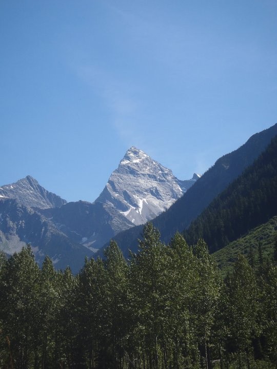
Mount Sir Donald with the super classic NW Ridge splitting it. (http://ericsbasecamp.net/trips/Uto-SirDonald/Uto-SirDonald.ht
Mount Sir Donald has been one of my dream ridge climbs out there. Indeed, it is one of the best long moderate rock routes anywhere. It is not anything to be taken lightly though in many ways. It features 2,700 feet of mostly low fifth class climbing with exposure of 1,000 to 3,000 feet on each side the whole way. It's mostly all knife edge climbing with a ton of vertical headwalls that are sometimes overhanging. It's almost 7,000 feet of elevation gain from the trailhead. The weather is much colder being far north. You can never escape the exposure so it can be mentally exhausting. On top of that the rock is all covered in lichen so when it's wet, it is very slippery and dangerous. Many deaths have occurred do to this. A very committing route that is located in the Selkirks in British Columbia, Canada. It's one of the 50 classics in North America and has been one of the best days in the mountains for me personally. Sir Donald from the highway with the NW ridge on the left skyline The Bivy view
I have always loved ridge climbs whether ridge climbs or traverses from the Capitol Peak and Snowmass Mountain traverse to just the Blitzen Ridge in the RMNP but this one simply was the best of the best for me. To pull it off, I believe it's more mental then anything. I was glad to have a bit of experience with exposure and soloing in that way. If you pitched it out, it would be almost like climbing the El Capitan. Even simul climbing it would take many hours. The best and fastest way is to solo it. Though rated 5.4, I started questioning that after pulling a few overhangs that were boulder problems with big exposure. Exposed Shawn climbing
Shawn and I came to the trailhead only to hear Sir Donald had gotten more snow and that it was out of condition for the rest of the year. In fact, that's what usually everyone is telling us. Most people seem to be trying to discourage us. I've learned the opportunity can't come unless your there. We decided we would go check it out and have a back up plan. After two days of straight sun, things were looking good, or were they? looks good so far!
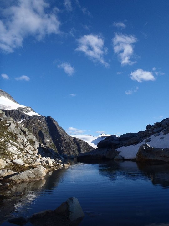
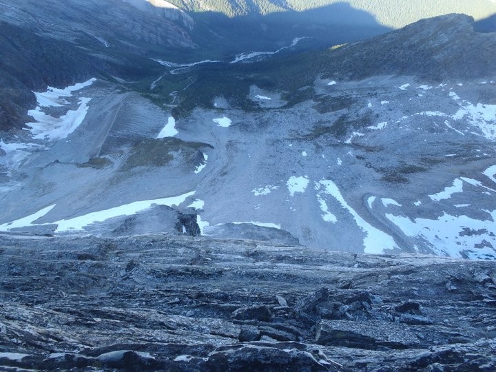
We approached the bivy camp which was a workout in itself. Almost 4000 feet in elevation gain in only a couple miles. I was glad to reach camp. All I brought to sleep in was a little bivy sack and my lightweight sleeping bag. I stared at the ridge, and oh my, it's like nothing I've seen before. It looked very exposed and way harder then 5.4 and long. I slept little. How could I with a clear sky and an amazing view of the stars above? sunset The col is reached by traversing a small ledge accross that face....The start of the route
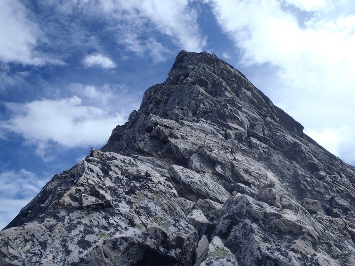
We started the approach from camp. It took about 50 minutes to get to the col, where the route starts. I will always remember standing there. Have you ever stood at the bottom of something so beautiful but yet intimidating that you can't speak for 10 minutes? It was almost like standing at the bottom of El Capitan except it was an alpine ridge. It was vast, big, and steep as anything. I personally was thinking "Is it really smart to not use a rope?" All the unroped deaths on the route came to my head. Then the wind was blowing just enough to make it cold and interesting. I knew Shawn was thinking the same thing. He brought the rope out but I distanced myself away from it so he would put it away. I was still set on soloing and we would have the rope just in case things got too spicy. That looked like it would be the case in 100 feet! There was already a party on it simul climbing. The view from the start of the route. A little bit into the route
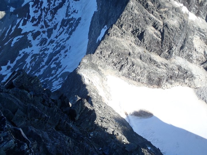
Off we go into the unknown. It took a couple hundred feet to get used to the climbing, rock, and your rhythm. Soon we passed the other party. The climbing never eased up the whole way. I never thought such a ridge existed. Fourth class after Fourth class move on a knife edges to countless 100 foot vertical headwalls. Even some overhanging 5th class climbing that had you hanging over the edge. I questioned the 5.4 rating as some of it, I really thought was 5.6 but everyone takes there own route. A little higher Again, great views! High up on the route Typical......North Face exposure West Face exposure
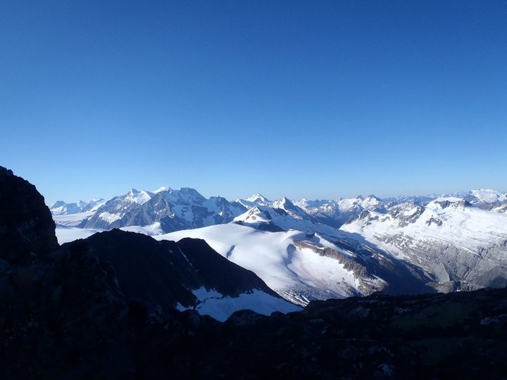
I was in perfect rhythm and so was Shawn. Once we got into the rhythm, there was no stopping. Soon we approached the summit pyramid where about 3 80 foot steep headwalls guard the summit. We surmounted them and encountered a few false summits. We just about ran to the summit. It was about 8:00 in the morning. I didn't even realize we did the route in an hour and a half. We were the first to summit in 7 days. It was windy and quite cold but I took it in. The views were spectacular with glaciers all over, and huge mountains around. We spent little time on the summit. The weather was good but we were getting cold, and getting down the ridge was going to be way harder then coming up. Summit! Shawn.....You can see the col wayy down there. Summit Ridge
We rappelled everything vertical while down climbing when possible. It took a little over 7 hours to get back to camp. We counted every rappel, and the ending count was 21. That's a lot of rappelling! Getting back to camp was gratifying. When you're in the "zone" for that long, it really can become mentally exhausting along with the exposure. Every second of it was "don't fall". We packed up and made the trudge back to the car. What a ridge. There is just so much climbing out there. Shawn rapping the middle of the route lots of going down! rap number 16 or 17? The Selkirks
Thumbnails for uploaded photos (click to open slideshow):
Wow, there's still so much snow up north! What a fast time to the summit! Just curious, did you guys rap all the way back to the col (reversing your ascent route on the NW ridge), or did you take the west face variation down from the ridge using the rappel stations? Very much enjoying your trip reports. Thanks for posting. Happy trails! :D
Lots of snow up North here. LOTS. We rapped and downclimbed until the bolted stations that took us over the lower west face. Standard descent these days and a little faster. All the rock was bombproof on the ridge. A couple loose rocks on ledges but overall very solid! Highly reccomended!!!
And very nice TR Noah. You are doing amazing climbs out there my friend. You have an amazing gift. Be safe!
Caution: The information contained in this report may not be accurate and should not be the only resource used in preparation for your climb. Failure to have the necessary experience, physical conditioning, supplies or equipment can result in injury or death. 14ers.com and the author(s) of this report provide no warranties, either express or implied, that the information provided is accurate or reliable. By using the information provided, you agree to indemnify and hold harmless 14ers.com and the report author(s) with respect to any claims and demands against them, including any attorney fees and expenses. Please read the 14ers.com Safety and Disclaimer pages for more information.
Please respect private property: 14ers.com supports the rights of private landowners to determine how and by whom their land will be used. In Colorado, it is your responsibility to determine if land is private and to obtain the appropriate permission before entering the property.


 Sir Donald from the highway with the NW ridge on the left skyline")
 The Bivy view")
 Mount Sir Donald with the super classic NW Ridge splitting it. (http://ericsbasecamp.net/trips/Uto-SirDonald/Uto-SirDonald.ht")
 Exposed")
 Shawn climbing")
 looks good so far!")
 sunset")
 The col is reached by traversing a small ledge accross that face....The start of the route")
 The view from the start of the route.")
 A little bit into the route")
 A little higher")
 Again, great views!")
 High up on the route")
 Typical......North Face exposure")
 Summit!")
")
 Shawn.....You can see the col wayy down there. Summit Ridge")
 Shawn rapping the middle of the route")
 lots of going down!")
 rap number 16 or 17?")
 West Face exposure")
 The Selkirks")


