Download Agreement, Release, and Acknowledgement of Risk:
You (the person requesting this file download) fully understand mountain climbing ("Activity") involves risks and dangers of serious bodily injury, including permanent disability, paralysis, and death ("Risks") and you fully accept and assume all such risks and all responsibility for losses, costs, and damages you incur as a result of your participation in this Activity.
You acknowledge that information in the file you have chosen to download may not be accurate and may contain errors. You agree to assume all risks when using this information and agree to release and discharge 14ers.com, 14ers Inc. and the author(s) of such information (collectively, the "Released Parties").
You hereby discharge the Released Parties from all damages, actions, claims and liabilities of any nature, specifically including, but not limited to, damages, actions, claims and liabilities arising from or related to the negligence of the Released Parties. You further agree to indemnify, hold harmless and defend 14ers.com, 14ers Inc. and each of the other Released Parties from and against any loss, damage, liability and expense, including costs and attorney fees, incurred by 14ers.com, 14ers Inc. or any of the other Released Parties as a result of you using information provided on the 14ers.com or 14ers Inc. websites.
You have read this agreement, fully understand its terms and intend it to be a complete and unconditional release of all liability to the greatest extent allowed by law and agree that if any portion of this agreement is held to be invalid the balance, notwithstanding, shall continue in full force and effect.
By clicking "OK" you agree to these terms. If you DO NOT agree, click "Cancel"...
Participants: cftbq, trishapajean
RT: 8.6 mi., approx. 3,900 ft. vertical
We left the new Rock of Ages TH at 5:25 am MST, just about sunrise. The trail first heads generally south and makes a couple of small switchbacks in the trees before reaching the junction where the Elk Creek Trail splits off to the right. Then one very long switchback heads up a west-facing slope of broken rock, finally curling around the north end of a ridge and entering Silver Pick Basin just below timberline.
The new trail is well signed at all the points where minor trails or disused roads might lead one off-route. This is where the views really begin to open up, especially to the north. Wilson Peak comes into view, close enough that climbers can be seen on the summit. But it's still a long way away.
From here on, all is broken rocks, in varying degrees of looseness. The trail traverses the west side of the basin, passes the remains of a truly impressive stone house,
(photo by trishapajean)
and climbs some steep switchbacks before rounding a corner (to hiker's right) and finally reaching the Rock of Ages saddle.
(photo by trishapajean)
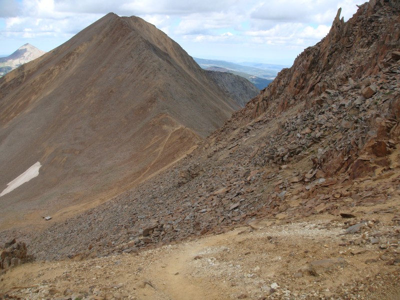
From here, the trail, still clear, does a gently rising traverse to a saddle on the Wilson Peak-Gladstone Peak ridge. (Actually this is not the low point on said ridge, which is farther south.) We felt we had made decent time to this point, but this is where progress slows dramatically for all but the most gifted of climbers.
From the saddle we turned left (NE), following a trail which quickly became faint and sketchy. The first obstacle is a rock rib, which is solid but lacks good ledges, and the shallow gully beyond it, which is full of loose rock. Both lack a clear trail and offer great fall possibilities. Beyond this, we found braided trail segments which gradually re-coalesced into a well-worn route. It climbs gradually toward the ridge crest
finally reaching a prominent low point perhaps half way along the ridge.
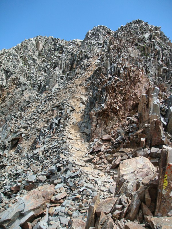
It got easier for a while. The trail stays just below the ridge as it heads toward the false summit (which now hides the real summit). At the base of the false summit block, the trail finally crosses over to the northwest (climber's left) side of the ridge, where a steep section leads to the top.
The view from this point is not encouraging.
However, as often happens, it actually isn't as hopeless as it at first appears to be. It's just really steep. Drop down on the well-worn trail to the small level platform below, just beside the spiky cliff face on climber's right. From there, a similar but longer series of steps and ledges leads up the other side, always hugging the cliff face just to the right. Some of the steps are big, but exposure is actually minimal and small handholds abound.
After climbing to an elevation just a bit higher than the false summit, we were finally able to stand up and walk, hands-free, to the true summit.
The 0.6 miles to the summit from the Rock of Ages saddle had taken us well over two hours. (In fairness to ourselves, we did a great deal better on the way down...)
After having the summit to ourselves for a while, we got the surprise of the day. Up strolled a climber with a collie-Australian shepherd mix dog! We had left our own pooch behind for this one (despite her demonstrated climbing skill), based on advice about the crux. All the same, here was this dog. (He had, it turns out, required a bit of lifting help from his human companions.)
The view from this summit is truly awesome. One of the things we observed was a burgeoning forest or range fire off to the northwest.
This peak turned out to be harder than I had expected. It's typically rated as easier than Mt. Wilson across the way"Class 3 as opposed to Class 4. If there's an overall difference, I found the reverse to be true. Nevertheless, it felt good to get back to the high country, and bag 14er number 49 (on the list of 54) for myself, 48 for trishapajean.
Thumbnails for uploaded photos (click to open slideshow):
The view from a far is always more daunting. Nice job and pics.
Ruff ruff!!
Caution: The information contained in this report may not be accurate and should not be the only resource used in preparation for your climb. Failure to have the necessary experience, physical conditioning, supplies or equipment can result in injury or death. 14ers.com and the author(s) of this report provide no warranties, either express or implied, that the information provided is accurate or reliable. By using the information provided, you agree to indemnify and hold harmless 14ers.com and the report author(s) with respect to any claims and demands against them, including any attorney fees and expenses. Please read the 14ers.com Safety and Disclaimer pages for more information.
Please respect private property: 14ers.com supports the rights of private landowners to determine how and by whom their land will be used. In Colorado, it is your responsibility to determine if land is private and to obtain the appropriate permission before entering the property.


")
")
")
")
")
")
")
")
")


