Download Agreement, Release, and Acknowledgement of Risk:
You (the person requesting this file download) fully understand mountain climbing ("Activity") involves risks and dangers of serious bodily injury, including permanent disability, paralysis, and death ("Risks") and you fully accept and assume all such risks and all responsibility for losses, costs, and damages you incur as a result of your participation in this Activity.
You acknowledge that information in the file you have chosen to download may not be accurate and may contain errors. You agree to assume all risks when using this information and agree to release and discharge 14ers.com, 14ers Inc. and the author(s) of such information (collectively, the "Released Parties").
You hereby discharge the Released Parties from all damages, actions, claims and liabilities of any nature, specifically including, but not limited to, damages, actions, claims and liabilities arising from or related to the negligence of the Released Parties. You further agree to indemnify, hold harmless and defend 14ers.com, 14ers Inc. and each of the other Released Parties from and against any loss, damage, liability and expense, including costs and attorney fees, incurred by 14ers.com, 14ers Inc. or any of the other Released Parties as a result of you using information provided on the 14ers.com or 14ers Inc. websites.
You have read this agreement, fully understand its terms and intend it to be a complete and unconditional release of all liability to the greatest extent allowed by law and agree that if any portion of this agreement is held to be invalid the balance, notwithstanding, shall continue in full force and effect.
By clicking "OK" you agree to these terms. If you DO NOT agree, click "Cancel"...
I frequently work in Aspen and as I cross the Maroon Creek bridge on highway 82 on my way into town I look off to my right and see Pyramid peak framed between Buttermilk and Aspen Highland ski areas. It's only in view for a moment but it is a sight to behold. Regal, majestic and towering over the Maroon valley it stands as a sentinel to watch over the people of Aspen.
I've wondered if I could climb it since the first time I saw it 21 years ago. It's often referred to as the 'third bell' given it's proximity to the other two. I have studied route descriptions and trip reports for some time now and decided it was time.
I noticed a request on 14ers.com last week for a climbing partner on Thursday. I replied with a request to change it to Saturday if possible and the time was set. Raj from Boulder met me at the trailhead at 3:00 a.m. by Maroon Lake. A couple of quick checks of equipment were in order and we headed down the trail at 3:05.
As we were walking and discussing other peaks we had climbed he mentioned that he had lost a GPS device 3 weeks earlier while climbing the Crestone Needle. On the day before our climb he purchased a new one of the exact same model. We came to the large cairn shaped like a pyramid and turned south to cross between Maroon and Crater lakes. The trail crosses the narrow valley and within about a quarter of a mile it starts climbing up a large scree field towards the ampitheater at the base of Pyramid. Raj was ahead of me and as he turned a corner on a switchback my headlamp reflected off of a cell phone through the mesh in a side pocket of his pack. I told him that he should probably secure that a little better and as he looked down he started laughing. He said "That's not a cell phone, it's the GPS that I lost." I tried convincing him the rest of the day that he needed to give me the extra one.
We arrived at the ampitheater and started hiking up through the huge scree, talus, and boulder field. I would describe the approach on this side of Pyramid as a large throne. The ampitheater is like the seat of a throne, the cliffs rising to the left and right are like armrests and the peak sits at the back of the ampitheater as if it were the back of the most majestic throne you have ever seen. Beautiful! And it was only just now coming into view as the sun started to rise. (This picture was actually taken on the way down; Too dark on the way up!)Pyramid at the back of the Ampitheater.
We stayed to the right side of a snowfield until we came close to the top of the ampitheater. We crossed over the field to the left and hiked over to the base of the cliffs of the Northeast ridge. It was now about 6:20. The pace was a bit slow for me but the most important thing in my opinion was staying with my climbing partner. I've soloed a peak before that was this difficult and got into trouble. It's always better to be able to look out for each other. About this time another climber named Josh caught up with us and asked to join us. We were glad for the company. He stayed with us for the rest of the day.
As we ascended the Northeast ridge I stopped on an outcropping and snapped this shot of a goat looking down on my partners. Goat overlooking Raj and Josh.
They were all over the mountain.
We reached the saddle on the ridge about 7:30 and the remaining climb came into view. Pyramid from the saddle.
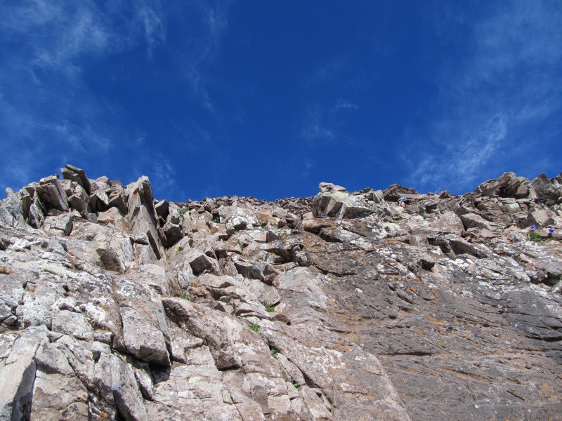
The band of light colored rock that rises up to the peak is the route that we took. We climbed up a ways along the right side of the ridge and eventually crossed over to the left side. From there we traversed to the left and came to the ledges.Raj on the ledges
They were not as intimidating as I thought they would be but in this territory any fall is bad news.You can barely see Josh's head sticking out in this one.Raj getting ready to climb the green wall.
After crossing the ledges we came to the light colored rock and headed straight up. Josh climbing the green wall.
There were plenty of cairns for trail markers but in this terrain there is no such thing as a trail. After coming almost to the top of the light colored rock we traversed to the left again and then started up through the final 200 feet of several class 4 sections.
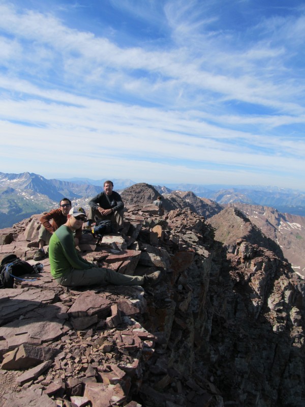
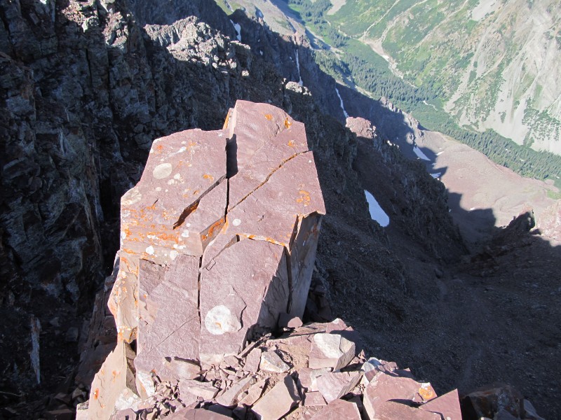
We finally summited at 9:12. There is a large rock sticking out to the west side of the summit towards the Maroon Bells and everybody wants their picture taken on it. If you were to fall off of it you would drop about 200 feet before hitting a 45-50 degree slope of loose scree and talus. Josh on the "Diving board".The Maroon BellsMe on the Diving boardRaj on the diving boardRaj, Josh and me
After taking pictures of about 7 different people on it, I wondered if anybody had ever planked it. The challenge went out and Josh responded immediately. Josh planking
In the back of my mind I could here my mother's voice saying "If you saw somebody jump off of a bridge would you do it too?" Unfortunately the answer for me was "Yes!"Me plankingThe "Diving Board"
One more guy named Morris Hogan did it and I promised I would post his picture in this trip report. When I got home I realized his picture was taken with his friends camera. Sorry Morris! Send me the picture and I'll post it here.
Here's a couple pictures of one of his friends.I'm not sure what this pose is called.The Captain Morgan pose
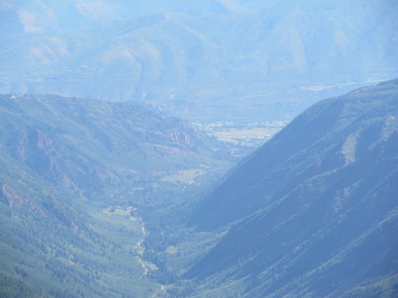
The weather was perfect and the Maroon valley was gorgeous!
We headed back down at 10:15. Route finding was tedious but we just took our time. The Maroon Valley with Aspen in the distanceCrossing a ledge
Once again there were plenty of natives to take pictures of. Me and Raj crossing over the ledges
As we made it to the bottom and back to Maroon Lake we had to stop for one last shot of the Bells.The Maroon Bells over Maroon Lake
We arrived at our cars at 2:56 p.m. A cold beer was waiting in the truck and a tired crew was only too willing to drink it. Thanks for a great climb Raj and Josh!
Thumbnails for uploaded photos (click to open slideshow):
Nice report Michael! My friend and I met you and your partner in the Amphitheater before the nasty gully leading to the ridge. Great weather that day, looks like you guys had a blast. It was good to meet you!
@ k-berger: It was nice to meet you too! @ Josh: I have the pictures on a disc now and I'll be sending them out tomorrow. I summited Little Bear yesterday and I'll be posting another trip report next week. Busy days!
Our trip is coming next weekend and your shots are helpful and amazing. Cheers!Thanks
Caution: The information contained in this report may not be accurate and should not be the only resource used in preparation for your climb. Failure to have the necessary experience, physical conditioning, supplies or equipment can result in injury or death. 14ers.com and the author(s) of this report provide no warranties, either express or implied, that the information provided is accurate or reliable. By using the information provided, you agree to indemnify and hold harmless 14ers.com and the report author(s) with respect to any claims and demands against them, including any attorney fees and expenses. Please read the 14ers.com Safety and Disclaimer pages for more information.
Please respect private property: 14ers.com supports the rights of private landowners to determine how and by whom their land will be used. In Colorado, it is your responsibility to determine if land is private and to obtain the appropriate permission before entering the property.


 Pyramid at the back of the Ampitheater.")
 Goat overlooking Raj and Josh.")
")
")
")
 Pyramid from the saddle.")
 Raj on the ledges")
")
 You can barely see Josh's head sticking out in this one.")
 Raj getting ready to climb the green wall.")
")
 Josh climbing the green wall.")
 Josh on the")
 The Maroon Bells")
 Me on the Diving board")
 Raj on the diving board")
 Raj, Josh and me")
 Josh planking")
 Me planking")
 The")
 I'm not sure what this pose is called.")
 The Captain Morgan pose")
")
 The Maroon Valley with Aspen in the distance")
")
")
")
 Me and Raj crossing over the ledges")
 The Maroon Bells over Maroon Lake")
 Crossing a ledge")


