Download Agreement, Release, and Acknowledgement of Risk:
You (the person requesting this file download) fully understand mountain climbing ("Activity") involves risks and dangers of serious bodily injury, including permanent disability, paralysis, and death ("Risks") and you fully accept and assume all such risks and all responsibility for losses, costs, and damages you incur as a result of your participation in this Activity.
You acknowledge that information in the file you have chosen to download may not be accurate and may contain errors. You agree to assume all risks when using this information and agree to release and discharge 14ers.com, 14ers Inc. and the author(s) of such information (collectively, the "Released Parties").
You hereby discharge the Released Parties from all damages, actions, claims and liabilities of any nature, specifically including, but not limited to, damages, actions, claims and liabilities arising from or related to the negligence of the Released Parties. You further agree to indemnify, hold harmless and defend 14ers.com, 14ers Inc. and each of the other Released Parties from and against any loss, damage, liability and expense, including costs and attorney fees, incurred by 14ers.com, 14ers Inc. or any of the other Released Parties as a result of you using information provided on the 14ers.com or 14ers Inc. websites.
You have read this agreement, fully understand its terms and intend it to be a complete and unconditional release of all liability to the greatest extent allowed by law and agree that if any portion of this agreement is held to be invalid the balance, notwithstanding, shall continue in full force and effect.
By clicking "OK" you agree to these terms. If you DO NOT agree, click "Cancel"...
CLIMBERS (Wetterhorn and Matterhorn, Day 1): Jeff (SurfNTurf), Chris 1 (ChrisinAZ), Chris "A" (sevenvii), Leah (MtnGoats) and Rope CLIMBERS (Uncompahgre, Day 2): Jeff (SurfNTurf), Chris 1 (ChrisinAZ), Chris "A" (sevenvii), Megan, Keri (Keri100474), Leah (MtnGoats) and Rope
My first home in the West was in Farmington, N.M., where I'd move from North Carolina after college. I got my first taste of the Rockies down there, as Farmington is only about 45 minutes south of Durango. I then bounced from Boston to Denver, however, and it had been nearly two years since I'd set foot in the San Juans. That was unacceptable.
I've held Uncompahgre on a pedestal since first seeing it from the top of Slumgullion Pass in 2009, and Wetterhorn scared the bejesus out of me in my early mountaineering days. I was looking forward to this trip, to say the least.
During the two weeks of planning, Leah (MtnGoats), Chris 1 (ChrisinAZ) and Chris "A" (sevenvii) -- they can't be Chris 1 and Chris 2 because they're equally badass -- all agreed to join at varying points. Megan, Keri (Keri100474) and Christina would do Redcloud/Sunshine and then meet us the next day for Uncompahgre. Leah's pup Rope would also be along for the ride.
After a five-ish hour drive from Denver, we took Chris A's 4Runner up to the Matterhorn Creek 4WD TH and pitched our tents next to his vehicle, settling into an early slumber at 9:30 p.m. Our alarms were set for 3 a.m.
ASIDE: The trailhead doesn't have much camping or parking spots, but be courteous, people. A truck steamrolled up at about 12:45 a.m. and the occupants pitched tents almost literally on top of ours - which was fine. Like I said, there's not much space up there. However, these upstanding citizens did so with about as much discretion as a freight train. Yelling, laughing, smoking, etc. It was mind-boggling. I assume they were from Texas.
So we set out on the trail at 3:45 a.m. on only a few hours of sleep. The approach into the basin is gentle, and I was surprised to learn we'd already gained 1,000 feet. By the time the sun started rising, we were approaching the Southeast Ridge proper. The views over Uncompahgre and Matterhorn were breathtaking.
Sunrise over Matterhorn and Uncompahgre
Important note: At the first trail junction while you're still paralleling the creek, stay RIGHT on the Ridge Stock Trail until you're well into the basin. There's a confusing sign for Wetterhorn down there that's not the correct path.
The trail peters out as you climb the ridge and it's good routefinding practice. I actually found this section more unnerving than the summit pitch, as there are some areas of loose scree above a bit of exposure. There isn't one correct way to get through this part, just find the easiest route - we each picked a little bit of a different line - and locate the gully that grants access to the base of the Prow.
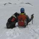
Rope the Superdog
Leah and me routefinding
Ridge walking
Chris 1 scrambling
It's amazing how quickly this climb passes. Before we knew it, we were at the Prow, staring at the last 150 feet to the summit and the V-notch that leads to the ramp and final pitch. We took a short break to get our minds right and enjoyed the sunrise views. It was still only about 6:30 a.m.
Reaching the Prow and the summit pitch along with the alpenglow (6:15 a.m.)
When we popped through the notch and made our way carefully down the ramp (ample handholds, but it's steeper than I'd expected), the much-anticipated summit pitch came into view. I remember thinking, "That's it?"
It looks so much more daunting in photos than it does in real life. All five of us, including Rope, scooted up without blinking an eye. We even stopped in the middle of the climb to look around, joke, take pictures, etc. - there wasn't a single scary moment. You reach a ledge about three-quarters of the way up, and you have the choice of continuing straight up or traversing around left to an easier route. We topped out at 6:45 a.m. to an absolutely stellar morning.
Me, starting up the 150-foot summit pitch
Leah and Rope, close behind
Psh, this is easy (and fun!)
A look down the summit pitch
Group summit shot (L-R: Chris 1, me, Leah, Chris "A"
Group summit plank. Rope wasn't enthused.
Downclimbing the summit pitch was a little more exciting, but we all took our time and made it down with ease. Chris 1 even scampered up the Prow for good measure.
Completely comfortable downclimb. What exposure?
Down we went. We debated going for Matterhorn or getting in the car and driving to Handies, since it was still early and the forecast was perfect. We decided on Matterhorn because it was staring us in the face. We left the trail after the rock outcroppings and made our way to a stream in the meadow.
ASIDE: While descending Wetterhorn we passed what we thought was the group that had been so rude the previous night. Of the five, only two had backpacks. Taking the high road, we rolled our eyes and moved on.
Onward to the Matterhorn
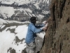
After refilling our water bottles, we began a short but tough slog up Matterhorn's grassy Southeast Slope. It was steep, but the footing was good. There isn't much of a trail. An eternity of rest-stepping finally brought us to the talus, and by that point the summit was in easy reach. There's a Class 2+ (maaaaaybe Class 3 for a move or two) route up a gully that zigzags to the right of the summit block. Leah, Rope and Chris "A" chose that route, while Chris 1 and I scrambled up mostly solid Class 3 rock on the left. Chris "A" wasted no time claiming the FPA (First Plank Ascent) of Matterhorn. As the day remained nearly perfect except for a few nonthreatening clouds, we again lounged for quite a while.
Approaching the final Class 3 summit push
Chris "A" claims the FPA (First Plank Ascent) of Matterhorn, with exposure
Relaxing on the Matterhorn
We were tired by this point, and dreading the descent down the grassy slope. Our mood quickly changed, though, when we saw that the wildflowers were out in full force. We regained the Ridge Stock Trail and hiked out, reaching the 4WD gate long before anticipated. How often does THAT happen?
Me, racing Rope down Matterhorn's summit block
Wildflowers on the grassy slope
We rendezvoused with Megan, Keri and Christina (who successfully summited both Redcloud and Sunshine) in Lake City and debated our options for the next day. Chris "A" had a 4Runner that would likely make the Nellie Creek TH, but the girls were in a 2WD Expedition. We discussed Handies and a few other options before deciding to stick with Uncompahgre by returning from whence we came and tackling its Southwest Slopes from Matterhorn Creek.
We found an awesome campsite slightly before the turnoff to the 0.7-mile 4WD road to the upper TH. We even had time to start a fire and make smores.
The forecast for Sunday was even better, so we decided to leave at 5 a.m. to reach treeline at sunrise and soak in the views. This plan didn't disappoint.
The now-larger group moving toward Uncompahgre on the Ridge Stock Trail
The Ridge Stock Trail is leisurely. It has its ups and downs, but even in the strenuous sections we were too busy looking at the views to worry about feeling fatigued. I can't stress enough how much we enjoyed doing Uncompahgre from this side...it's a bit longer than the standard route, sure, but it's one of the best approach hikes I've ever done.
After a few miles, the route finally starts feeling like a 14er and goes up. Two steep sections - an ascending traverse on a scree path and a grass slope - brought us to the intersection with the standard trail.
Grassy slope and trail, almost to junction with the standard route
On the standard route now, Uncompahgre's upper section on display
The route's obvious from here. We followed the trail up the ridge into a few switchbacks, then entered the talus. It's loose junk, but there are handholds and the Class 2+ section is short. When you emerge, there's still a bit of a jaunt to the summit but it's enjoyable and easy Class 1 trail hiking. We topped out at a little after 9 a.m.
The views from Umcompahgre are (I'm sorry) Uncompahgrable. Best summer scenery yet. Not only did we have a sweet view of Wetterhorn and Matterhorn, but also: Redcloud/Sunshine, Handies, the Wilsons, El Diente, Sneffels, the Grenadiers, the Western Slope, and more 12ers and 13ers than I can name. We spent an hour up there that felt like three minutes.
The Wilsons and El Diente, from Uncompagre's summit
Wetterhorn and the distant Sneffels
Obligatory summit shot
Finally forcing ourselves to depart, we started the long hike back to Matterhorn Creek. We took our time, as the alpine scenery is absolutely perfect. We took many rest breaks and I probably snapped 100 photos on the descent alone. We reluctantly returned to treeline and made our way back to the vehicle. The San Juans are everything I remember them to be and more. Anyone hiring in Durango?
Leah and Rope, reveling in the alpine
22+ miles and 10,500 in two days? Nap time.
Chris 1, planking with a view
One more look at the stately Chief of the San Juans
The group hiking out, saying goodbye to Wetterhorn
Thumbnails for uploaded photos (click to open slideshow):
Great to hear that you felt the summit pitch wasn't as bad as it looks. It sure looks daunting on your photos. We are hoping to do Wetterhorn this year. That wildflower photo is awesome. Looks like it was well worth the time to go up Matterhorn.
Excellent TR and photos. I did Wetterhorn on June 28th. To iterate another here, the wild flower photo you took was choice. As to the summit pitch, ”it's all relative”! It is definitely class 3 and a slip would most likely be fatal. To others out there....be prepared for a short, exciting, scary, class 3 summit pitch. What seems easy to one could be very different for you. Plenty of hand holds, but definitely dangerous. Climb Safe my Friends!!!
Caution: The information contained in this report may not be accurate and should not be the only resource used in preparation for your climb. Failure to have the necessary experience, physical conditioning, supplies or equipment can result in injury or death. 14ers.com and the author(s) of this report provide no warranties, either express or implied, that the information provided is accurate or reliable. By using the information provided, you agree to indemnify and hold harmless 14ers.com and the report author(s) with respect to any claims and demands against them, including any attorney fees and expenses. Please read the 14ers.com Safety and Disclaimer pages for more information.
Please respect private property: 14ers.com supports the rights of private landowners to determine how and by whom their land will be used. In Colorado, it is your responsibility to determine if land is private and to obtain the appropriate permission before entering the property.


")


")


 of Matterhorn, with exposure")


 Sunrise over Matterhorn and Uncompahgre")
 Leah and me routefinding")
 Rope the Superdog")
 Chris 1 scrambling")
 Reaching the Prow and the summit pitch along with the alpenglow (6:15 a.m.)")
 Me, starting up the 150-foot summit pitch")
 Leah and Rope, close behind")
 Completely comfortable downclimb. What exposure?")
 A look down the summit pitch")
 Group summit shot (L-R: Chris 1, me, Leah, Chris \"A\"")
 Group summit plank. Rope wasn't enthused.")
 Onward to the Matterhorn")
 Approaching the final Class 3 summit push")
 Chris \"A\" claims the FPA (First Plank Ascent) of Matterhorn, with exposure")
 Relaxing on the Matterhorn")
 Me, racing Rope down Matterhorn's summit block")
 Wildflowers on the grassy slope")
 The now-larger group moving toward Uncompahgre on the Ridge Stock Trail")
 Ridge walking")
 Grassy slope and trail, almost to junction with the standard route")
 On the standard route now, Uncompahgre's upper section on display")
 Psh, this is easy (and fun!)")
 The Wilsons and El Diente, from Uncompagre's summit")
 Wetterhorn and the distant Sneffels")
 Obligatory summit shot")
 Leah and Rope, reveling in the alpine")
 22+ miles and 10,500 in two days? Nap time.")
 Chris 1, planking with a view")
 One more look at the stately Chief of the San Juans")
 The group hiking out, saying goodbye to Wetterhorn")