| Report Type | Full |
| Peak(s) |
Missouri Mountain - 14,071 feet Iowa Peak - 13,840 feet Emerald Peak - 13,916 feet Mt. Oxford - 14,158 feet Mt. Belford - 14,202 feet |
| Date Posted | 07/24/2011 |
| Date Climbed | 07/23/2011 |
| Author | KansanClimber |
| Degrees of Solitude |
|---|
|
Peaks/routes: Missouri Mountain via Northwest ridge Iowa Peak via North ridge Emerald Peak via Northeast Ridge Mt Oxford via Elkhead pass Mt Belford via Elkhead pass Duration: 11 hours Distance: ~17.25 Gain: ~8300' My obligatory confession. I don't normally write trip reports...mainly because the hikes/climbs that I go on rarely tend to be eventful, nor do I often have anything useful to report. Finally, however, it looks like I have some useful info...oh, and I'm sort of proud of that day too. So here it goes. Degrees of Solitude.A painful shrieking awakens me. Everything is dark, and I fumble around trying to find the clock but it's hiding. The shrieking speeds up and goes to another decibel level. Found it! I silence the demonic alarm and groan. It's 4:00am and I've got a splitter headache. Curse that wine... I think to myself. I start getting ready and finally exit my car. The morning air is surprisingly warm. The past few nights it's been way colder, but then it occurs to me that I'm only at 9,600 feet instead of the 12,000+ that I'd been at the past two nights. This trip started Wednesday night when my boss called and told me that they didn't have any work for me the rest of the week. I decide on a whim to head out. I chose the Decalibron ridge for the first day. It went easily, and I was able to drive over to Sherman which I knocked off during a moderate weather window that afternoon. On the drive in to Sherman, I was struck by the beauty of a neighboring peak, which I later learned was called Horseshoe peak. I decided to do Sheridan, Peerless, Horseshoe, and some small hump not worth calling a peak. By the end of Friday, I'd hiked over 19 miles and spent 14 hours moving. Feeling psyched but tired, I went to Buena Vista and got online to pick my target for Saturday. I'm not a huge fan of the Sawatch range, since they tend to be long scree-slogs, so when I chanced on a picture from the summit of Huron with a beautiful, pyramid 13er in the background, I got excited. I'd actually seen the same picture of Emerald peak a few years earlier while surfing the net in a boring accounting class. I did the research, and elected for Missouri's west ridge. An interesting note, the route description on here and SummitPost are different from the one in the National Geo topo. I decided to go up the SP route, and try and descend the topo way. However, I was foiled by the high waters at the fords...about 20 inches at the first crossing at 6pm. I was relegated to the busy and bustling Missouri Gulch. I had barely parked before I was assaulted by another hiker demanding to know what I was going to do tomorrow. A little put off by the crowds, I grabbed my bottle of Malbec and Steve Houses' book that I was rereading and sat down to mentally check-out. I must have drunk a little more than I thought, as the splitter headache was a wonderful morning present. I was on the move by 4:30am, and the hike up into the basin was steep, but uneventful. I passed a few groups, but all but one of them were going for Belford or Oxford. As I reach the junction for Elkhead Pass, I could see a group ahead of me. Always competitive, I made it my goal to catch them before the summit. They were about 1200' above me, and I wasn't able to catch them. I could feel some fatigue in my legs, which was annoying. As I climbed the last 50 feet to the summit a Texan with a floppy hat said "You're almost done!!" I snorted, but smiled and tried to be polite. "I'm just getting started..." I thought. It took me 3.5 hours to get to the top. On the summit I pulled out my map, and plotted my next step. At this point, I hadn't thought I would try for B&O, but as I looked at the route, I decided to try for it. I would climb over Iowa and up to Emerald, then descend into South Missouri basin and go over Elkhead pass. If the weather held, I would continue up. If not, I would just hike out. The traverse over to Iowa was simple, and with less than 300' of gain it took only 30 minutes. The trail phased out at the bottom of the saddle. There is definitely a trail going down the west side, so my topo is right, but whether it's another trail or they changed the west ridge route I'm not sure.  On the summit, I enjoyed the views for a little bit, but I was getting hungry, and I had to be on Emerald to eat my sandwich (it's "the carrot and the donkey" but self-inflicted). Thus, motivated by food I started my descent. I aimed for the left most ridge, which appeared to be the least steep and most solid. I quickly made the saddle, and jogged the easy ground to the base of Emerald's Northeast ridge. About half way up, I intersected a faint trail, and followed that most of the way to the summit. The views were amazing, and the solitude was incredible. I couldn't see anybody, I was utterly alone, and I was surrounded by wilderness. I was on the summit 5 hours from the start, but it felt like 2...I was having too much fun! I ate my sandwich, took a few pictures, and started down.  On the way down, I followed the trail all the way to the bottom of the slope. The current trail goes up the center of the North face, but it's loose and dirty, so I would recommend going to the left instead.  The west side of the basin has several tiers, and I would have to work my way down these to intersect the trail up to Elkhead pass. I stayed as high as I could so as to minimize the amount I would have to regain, and because the basin looked pretty soggy from all the snowmelt. That basin is amazing, and I loved every minute of it. So beautiful. I was starting to get tired though, and when I finally started climbing up the pass, I was hit by a sudden wave of fatigue. My stomach started revolting, and I slowly made my way to the top of the pass where I collapsed behind the cairn. I managed to choke down a few cliff blocks. As I sat down it occurred to me that my body was reacting exactly like it did during my last ultra (North Fork 50). Laughing to myself at my pathetic state of being, I stumped off up to Belford's south ridge. 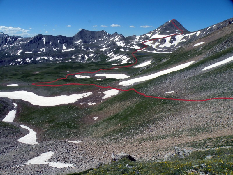 The slope was mercifully not that steep and I made fair time. I started down the saddle over to Oxford and was hit in the face by a swarm of people. Fat people, loud people, dog people, even KID PEOPLE! (Side note, there was a girl, probably about 9, who was absolutely crushing it. Way to go! Major props kid!) I wasn't in the most cheerful state of mind, and going from pure solitude to a crowd with no transition didn't improve my state of mental opinion. Now, I'm not a prick, or at least I try not to be. I love seeing people get outdoors and enjoy nature...just so long as they do it quietly and respectfully to both the mountains and to the people around them. Alas, that was not the case today. I was able to get around most people (several were kind enough to move to the side and let my by, thanks guys!) and made good time to Oxford. I'd been on the move for 8.5 hours and really wanted a break, but Oxford was as busy as the college during exams, but nowhere near as quiet. I think something about altitude makes people want to pour their life stories out. Or brag about how many 14ers they'd done. I sat quietly nibbling on some dried appricots (best life decision, they have LOADS of potassium) for a few minutes. One guy looked at me and asked how many I'd done. "Some" I said to which he promptly crowed "I've done 34!" I smiled and mumbled something positive back and started packing up. I walked down the saddle, and back up the other side and climbed the last few feet to Belford. It was even more crowded, and I braced myself for another purgatory, but surprisingly everyone was quiet. Some were napping, others just sitting. As I stepped up, an older guy quietly asked me how long the saddle had taken me. I told him about an hour, but that I was moving slow. He thanked me and I walked over to a flat section and sat down to enjoy (surprisingly) the peacefulness of the summit. I'd done it, and was ready to climb back down. My stomach eased, and I started the toe-mashing descent. Side note to my fellow trail runners out there, I saw three different people running the main approach trail. It's certainly runable, but it's steep and rocky. An hour and half later, I was down to my car. I dumped everything into my car, took off my shoes. I turned around one last time to look at what I'd just done. All I could see was the steep green forest rising into the sky. I got in my car, and drove back to the springs for the ice climbing fest my gym was putting on. Three hours later I sat in the gym sipping a beer and contemplating the past 3 days. I realized how blessed I was to have those experiences. I may not have worked, but God is good and He gave me mountains to play in, a body to use, and a soul to fill. Life is good. Now, despite my love of solitude, I'm in need of a competent partner for either Little Bear, Capital, or both. Any takers? Now, away from the self-advertisement, here are some closing pics.     Thumbnails for uploaded photos (click to open slideshow):  the top of the trail shown on the NG topo. This is at the bottom of the Iowa-Missouri saddle")
 a look back on the route from Missouri")
 The red line is the route I took, while the green is roughly the established trail")
 route off of emerald and through the basin")
 Ice mountain and North Apostle right? Anyone wanna try them with me?")
 most of the route can be see from here.")
")
 the wildflowers were in bloom everywhere!")
|
| Comments or Questions | |||
|---|---|---|---|
|
Caution: The information contained in this report may not be accurate and should not be the only resource used in preparation for your climb. Failure to have the necessary experience, physical conditioning, supplies or equipment can result in injury or death. 14ers.com and the author(s) of this report provide no warranties, either express or implied, that the information provided is accurate or reliable. By using the information provided, you agree to indemnify and hold harmless 14ers.com and the report author(s) with respect to any claims and demands against them, including any attorney fees and expenses. Please read the 14ers.com Safety and Disclaimer pages for more information.
Please respect private property: 14ers.com supports the rights of private landowners to determine how and by whom their land will be used. In Colorado, it is your responsibility to determine if land is private and to obtain the appropriate permission before entering the property.


