Download Agreement, Release, and Acknowledgement of Risk:
You (the person requesting this file download) fully understand mountain climbing ("Activity") involves risks and dangers of serious bodily injury, including permanent disability, paralysis, and death ("Risks") and you fully accept and assume all such risks and all responsibility for losses, costs, and damages you incur as a result of your participation in this Activity.
You acknowledge that information in the file you have chosen to download may not be accurate and may contain errors. You agree to assume all risks when using this information and agree to release and discharge 14ers.com, 14ers Inc. and the author(s) of such information (collectively, the "Released Parties").
You hereby discharge the Released Parties from all damages, actions, claims and liabilities of any nature, specifically including, but not limited to, damages, actions, claims and liabilities arising from or related to the negligence of the Released Parties. You further agree to indemnify, hold harmless and defend 14ers.com, 14ers Inc. and each of the other Released Parties from and against any loss, damage, liability and expense, including costs and attorney fees, incurred by 14ers.com, 14ers Inc. or any of the other Released Parties as a result of you using information provided on the 14ers.com or 14ers Inc. websites.
You have read this agreement, fully understand its terms and intend it to be a complete and unconditional release of all liability to the greatest extent allowed by law and agree that if any portion of this agreement is held to be invalid the balance, notwithstanding, shall continue in full force and effect.
By clicking "OK" you agree to these terms. If you DO NOT agree, click "Cancel"...
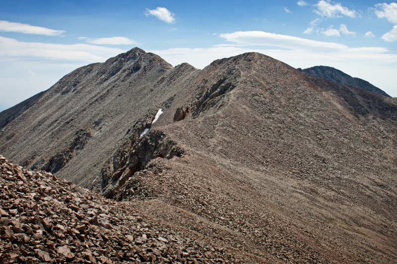
West Ridge between Point 13,936 and Tabeguache
After struggling up the Angel of Shavano and failing to make the traverse over to Tabeguache this past May, I decided to give Tab another try. My wife, having researched several trip reports and consulting one of our three copies of Roach's book, suggested we try the West Ridge route. We left the car at 4am and walked up the road to the trailhead, which we located the night before (the trailhead can be difficult to find unless you carefully measure the 7.6 miles from highway 50 or use GPS coordinates). We reached the trail and headed into the woods. I love the predawn time spent on the trail, and it is always an added bonus to be in the company of a full moon. The trail was easy to follow with our headlamps and we made decent time on this section. Still under the cover of darkness, we reached the small pond which marks the point where the West Ridge route leaves the closed Southwest Ridge Trail. The term 'bushwhacking' sends chills down my spine and I was expecting the worst, but the valley turned out to be a very pleasant off trail hike all the way to the saddle.
Approximate route through the valley in blue, naughty route in red (taken from just above the saddle on return)
As the sun began to light the morning sky, we became aware of all the flowers that filled the valley.
The hills are alive...Bert strikes her 'Sound of Music' pose
The number of Columbine alone was incredible. If Enos Mills were alive today he would have ate two raisins, wrestled a bear, and then proceded to count 2,153,829 individual Columbines. This is, of course, a gross exaggeration, but it was definately the most Columbine I have ever seen on a hike before. We gradually made our way up to the saddle.
Carbonate Mountain from the saddle
We took a short break at the saddle and started the slow, steep scree ascent toward the intimidating false summit that is Point 13,936. I knew this was a false summit, so I wasn't surprised when I saw Tabeguache come into view behind it. I was, however, expecting the ridge between the two to be an easy little stroll, but there are several minor summits in between that must be either skirted or climbed over.
First of the minor summits
One bonus of climbing over these is a short class 3 down climb on the final minor summit.
Final minor summit downclimb
We reached the summit in a mere five and a half hours (gulp...that's why we start early). Summit
Thumbnails for uploaded photos (click to open slideshow):
I gather this is the Jennings Creek TH? Do you have any more photos or particulars of the route? I've been shunned from Tab on 2 Shavano ascents and have given up going that route again. I've got my eyes on Jennings but want to soak up more info before trying. Thanks
Thanks for the TR. We may try Tab via this route Sat. Can you give us some beta on the 4WD road condition? Can my Explorer make it, or is my Wrangler needed? Also, are there decent camp spots at or near TH? Any help would be appreciated!!
The road is a bit rough in spots, but not horrible. We drove up it in our Outback, so I'd guess an Explorer would be fine. It looked like there were several campsites along the road on the way to the trailhead.
Have fun!
Caution: The information contained in this report may not be accurate and should not be the only resource used in preparation for your climb. Failure to have the necessary experience, physical conditioning, supplies or equipment can result in injury or death. 14ers.com and the author(s) of this report provide no warranties, either express or implied, that the information provided is accurate or reliable. By using the information provided, you agree to indemnify and hold harmless 14ers.com and the report author(s) with respect to any claims and demands against them, including any attorney fees and expenses. Please read the 14ers.com Safety and Disclaimer pages for more information.
Please respect private property: 14ers.com supports the rights of private landowners to determine how and by whom their land will be used. In Colorado, it is your responsibility to determine if land is private and to obtain the appropriate permission before entering the property.


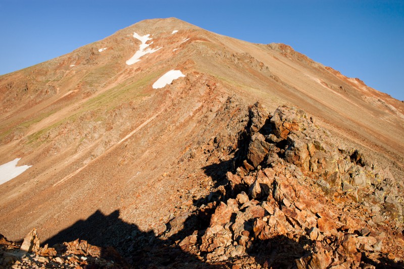


 Carbonate Mountain from the saddle")
 West Ridge between Point 13,936 and Tabeguache")
 First of the minor summits")
 Final minor summit downclimb")
 Approximate route through the valley in blue, naughty route in red (taken from just above the saddle on return)")
 The hills are alive...Bert strikes her 'Sound of Music' pose")
 Summit")