Download Agreement, Release, and Acknowledgement of Risk:
You (the person requesting this file download) fully understand mountain climbing ("Activity") involves risks and dangers of serious bodily injury, including permanent disability, paralysis, and death ("Risks") and you fully accept and assume all such risks and all responsibility for losses, costs, and damages you incur as a result of your participation in this Activity.
You acknowledge that information in the file you have chosen to download may not be accurate and may contain errors. You agree to assume all risks when using this information and agree to release and discharge 14ers.com, 14ers Inc. and the author(s) of such information (collectively, the "Released Parties").
You hereby discharge the Released Parties from all damages, actions, claims and liabilities of any nature, specifically including, but not limited to, damages, actions, claims and liabilities arising from or related to the negligence of the Released Parties. You further agree to indemnify, hold harmless and defend 14ers.com, 14ers Inc. and each of the other Released Parties from and against any loss, damage, liability and expense, including costs and attorney fees, incurred by 14ers.com, 14ers Inc. or any of the other Released Parties as a result of you using information provided on the 14ers.com or 14ers Inc. websites.
You have read this agreement, fully understand its terms and intend it to be a complete and unconditional release of all liability to the greatest extent allowed by law and agree that if any portion of this agreement is held to be invalid the balance, notwithstanding, shall continue in full force and effect.
By clicking "OK" you agree to these terms. If you DO NOT agree, click "Cancel"...
Bierstadt & the Sawtooth from the willow field on Guanella Pass
We climbed Bierstadt and the Sawtooth on Friday, June 24th, the day before the fatal fall. Let me say that the reports of the treacherous snow on the Sawtooth are not exaggerated. The snowfields are extensive and sluff off easily as you traverse them. The route up Bierstadt is easy and clear and should not be taken as an indication of the conditions on the Sawtooth.
Our total climb time up Bierstadt was around 2 hours (we started at 11 due to the road construction on the Georgetown side - Use the 285 side from Grant). After stopping on the summit for about 30 minutes to survey the Sawtooth, we headed out. As you can see in the picture below, the snow fields on the east side of the Sawtooth are very substantial, so we decided to avoid them on our crossover. The final picture shows the substantial snow field you'll also want to avoid coming down from Bierstadt to the Sawtooth (we climbed down the rocks instead - very slow). It took significantly longer to cross the Sawtooth than it did to climb Bierstadt.
Avoiding the snow on the Sawtooth meant climbing or traversing the rocks as much as possible, which was scary at times. The west side of the Sawtooth is largely sheer faces down to the scree field, while the east side had large snowfields leading down to Abyss Lake. We moved very carefully and slowly, having to backtrack several times to find a way across the rocks. The trail across the Sawtooth the is marked by cairns leads to snowfield crossings, which we had to make our way around.
Once we reached the Evans side of Sawtooth, it was late in the day. We bailed on Evans to make sure we had enough light to make it back to Guanella Pass. We didn't cross back to Bierstadt on the Sawtooth, deciding instead to head back down towards Guanella Pass from where we were at on the back side of Evans, walking around the bowl and following the creek down towards the lake. The descent was easy until we reached the WILLOWS. The willows are thick and stretch FAR, requiring significant time to get through. Additionally, the significant runoff has filled all of the boggy areas which are messy to get through. YUCK.
Inside of the Sawtooth from Mt. Bierstadt
Descent down Bierstadt to the Sawtooth taken from the back of Mt. Evans
Thumbnails for uploaded photos (click to open slideshow):
Nice job navigating all this. My friends and I were thinking about doing this route this weekend (July 2), but not reading your report and looking at your picture....we might want to wait another couple of weeks.
I am a 14er newbie, with only Holy Cross and Sherman under my belt. When I look at pics of the ledges on Sawtooth, it looks pretty intimidating. Can you give me your opinion of these ledges (west side) from your perspective this weekend? Thanks!
Caution: The information contained in this report may not be accurate and should not be the only resource used in preparation for your climb. Failure to have the necessary experience, physical conditioning, supplies or equipment can result in injury or death. 14ers.com and the author(s) of this report provide no warranties, either express or implied, that the information provided is accurate or reliable. By using the information provided, you agree to indemnify and hold harmless 14ers.com and the report author(s) with respect to any claims and demands against them, including any attorney fees and expenses. Please read the 14ers.com Safety and Disclaimer pages for more information.
Please respect private property: 14ers.com supports the rights of private landowners to determine how and by whom their land will be used. In Colorado, it is your responsibility to determine if land is private and to obtain the appropriate permission before entering the property.
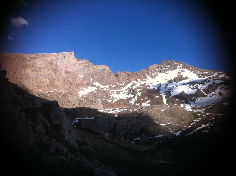


 Bierstadt & the Sawtooth from the willow field on Guanella Pass")
 Inside of the Sawtooth from Mt. Bierstadt")
 Descent down Bierstadt to the Sawtooth taken from the back of Mt. Evans")

