Download Agreement, Release, and Acknowledgement of Risk:
You (the person requesting this file download) fully understand mountain climbing ("Activity") involves risks and dangers of serious bodily injury, including permanent disability, paralysis, and death ("Risks") and you fully accept and assume all such risks and all responsibility for losses, costs, and damages you incur as a result of your participation in this Activity.
You acknowledge that information in the file you have chosen to download may not be accurate and may contain errors. You agree to assume all risks when using this information and agree to release and discharge 14ers.com, 14ers Inc. and the author(s) of such information (collectively, the "Released Parties").
You hereby discharge the Released Parties from all damages, actions, claims and liabilities of any nature, specifically including, but not limited to, damages, actions, claims and liabilities arising from or related to the negligence of the Released Parties. You further agree to indemnify, hold harmless and defend 14ers.com, 14ers Inc. and each of the other Released Parties from and against any loss, damage, liability and expense, including costs and attorney fees, incurred by 14ers.com, 14ers Inc. or any of the other Released Parties as a result of you using information provided on the 14ers.com or 14ers Inc. websites.
You have read this agreement, fully understand its terms and intend it to be a complete and unconditional release of all liability to the greatest extent allowed by law and agree that if any portion of this agreement is held to be invalid the balance, notwithstanding, shall continue in full force and effect.
By clicking "OK" you agree to these terms. If you DO NOT agree, click "Cancel"...
How to turn a mellow 8 mile Class 2 hike into a 12-hour Class 4 adventure without really trying
How to turn a mellow 8 mile Class 2 hike into a 12-hour Class 4 adventure without really trying
Peaks: Mt. Lindsey and Northwest Lindsey Route: Roundabout via Lindsey-Blanca traverse Date: June 12, 2011 Length: About 10-12 miles Vertical: A lot of ups and downs. Probably between 5,000 and 6,000 Time: under 12 hours Who: Lynn (LynnKH) and Natalie (nkan02)
LynnKH and I teamed up again this past weekend to attempt a mellow hike up Mt. Lindsey. We were planning to do Class 4 ridge near the top and maybe bag a nearby 13-er for added fun. We got a pretty late 6.20am start, expecting an easy day (and "0" chance of precipitation), and were merrily skipping along a nice flat dirt trail admiring the unfolding views and reviewing our past weekend adventures and possible future weekend plans.
Cheerfully we blasted past the Lily Lake TH sign to arrive at the Huerfano river crossing. There was no bridge and the creek was gushing down with all the snowmelt it has recently received. Confused we went back to the Lily Lake TH sign and studied the TR description. For whatever reason we read "do not turn right at the Lily Lake TH" as "do turn right at the TH" - well it was 6.30 am in the morning. Relieved that we did not have to cross the ominous looking river without the help of the bridge we cheerfully dashed along, once again admiring the views and the nice easy flat trail. After a mile or two of this we suddenly found ourselves somehow bumped against the north wall of Blanca.
After Lynn suggested we follow the trail to the right, I vaguely recalled that Blanca and Ellingwood Point should be far to the right from where we needed to be at this point. Similarly, I recalled that the ascent of EP from the north side is rated 5.0-5.2 in the Roach book. We unfolded the maps and studied the TR instructions once again. Ellingwood Point (or one of 3 of them - I'll get to this in a minute) loomed immediately in front of us. It became pretty clear that we overshot a standard trail by about a mile or two.
Our options were to turn around and look for the proper trail (how lame!) or to climb a beautifully laid out boulder field immediately in front of us.
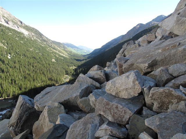
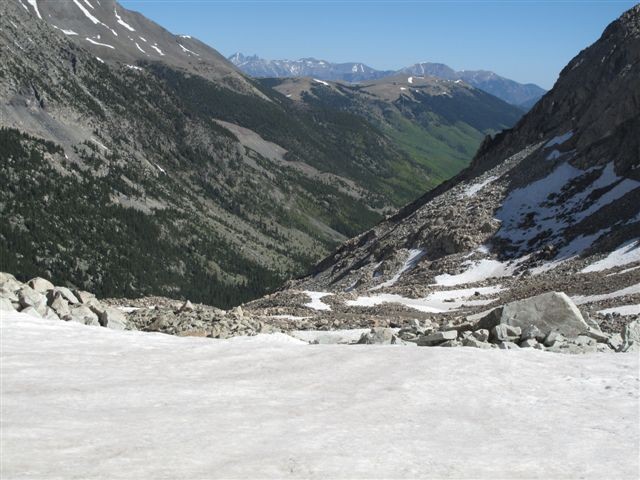
Surprise, surprise, we chose the latter. Half an hour later we found ourselves on top of Class 3 trail entering a higher amphitheater. We knew that we were a bit lost, but the views around us were so stunning, that I did not think we minded it at all.
After gaining the highest point on the next plateau (about 11,700 feet at that point) we studied our options once again: 1) we could go along the higher ridge to the left (which did not look appealing due to apparent loose talus and somewhat limited views) 2) climb the ridge head on (vetoed due to visible traces of rockfall and steepness) or 3) continue a gradual ascent to the right through the beautifully framed snow-filled valley with a nice-looking exit ridge at the end. We chose the 3rd option.
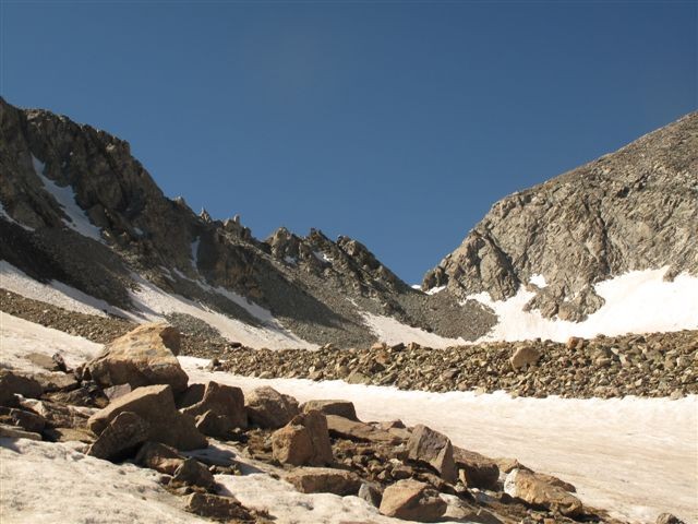
Again, we were not sure 100% about our location and the three Ellingwood Points continued to look confusing, but the views were not disappointing.
The Ellingwood Point must be on the right (or left?) wait, which one is EP? Left or right?
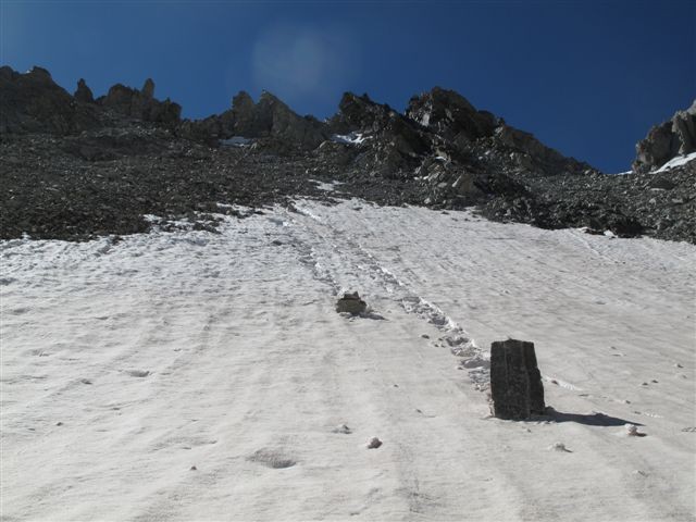
After approaching the end of the ridge we again saw the traces of the recent rockfall.
wowza
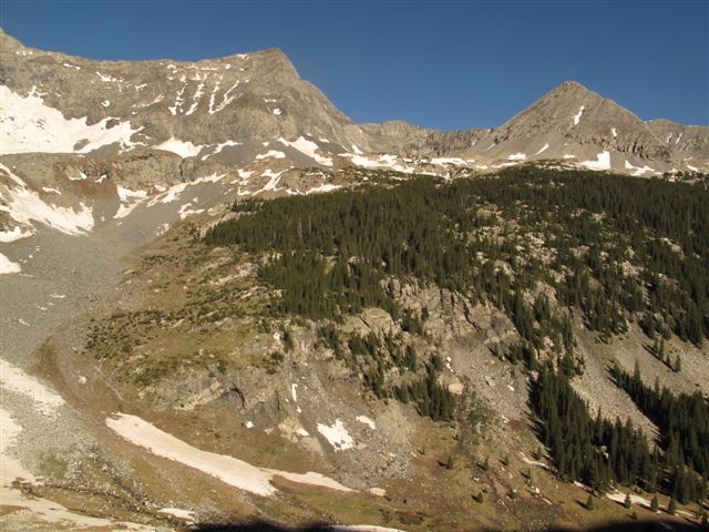
Alarmed, I suggested we skirt the ascent gulley sticking to the snow and rocks on the right side. However, Lynn, correctly predicting that this could possibly be the Lindsey-Blanca traverse ridge, suggested entering the ridge as far to the left as possible, just in case we will have to traverse back to the left to get to Lindsey. The ridge in fact was none other but the L-B traverse. As we were gaining the 2nd ridge of today, the views started to unfold.
We were also glad to see some faint traces of footprints, likely of people exiting or entering the traverse, so we got mildly encouraged. After topping off on the ridge we could see the full picture. Lynn uttered the seminal words: "It looks like we have finally found the right mountain", correctly pointing out to Mt. Lindsey looming about a mile and a half to the left, and thus sending me into an uncontrollable fit of laughter.
Here is the correct mountain
At this point we were finally able to differentiate Blanca and Ellingwood Point from an unnamed EP-look-alike.
On top of the Lindsey-Blanca traverse
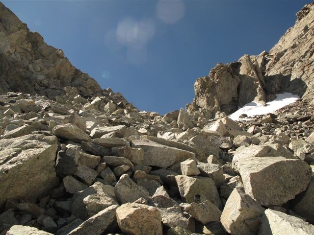
How do we get back to Lindsey from half-way the Lindsey-Blanca traverse - that was La Question Du Jour. Again, it appeared that we had a couple of attractive options to consider - 1) to climb up the ridge that looked to me like a Class 5 climb with unclear descent prospects on the other end and a possibility of being cliffed out half-way
Going up?
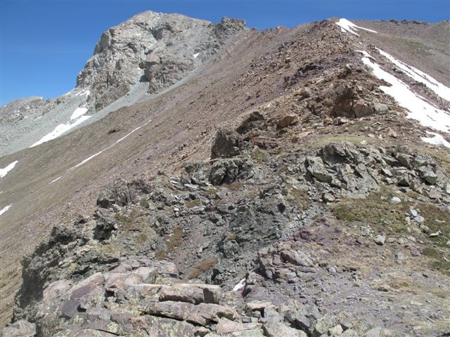
or 2) to downclimb a nice-looking Class 4 gulley, traversing a few short snow fields and regain the grassy hill on the other side.
or down?
We went with the 2nd choice. Slowly downclimbing through the gulley we dropped down to the beginning of the snowfields. I led the climb by making footsteps in the snow. The snow was good - not too firm, not posthole-prone, so steps were not an issue. However, upon reaching the snowfield, Lynn was not happy with the traction in her boots and microspikes, so we chose to climb a bit higher to gain an added support of the rocks. The lower part of the traverse very much reminded me of the Blanca-Ellingwood traverse that I've recently completed, but the gulley itself was a bit steep.
This is the gulley we downclimbed into. It turned out a bit steep.
Upon reaching the grassy slope, we regained elevation to observe our further options and were greeted by this guy.
The options did not look bad either, although the future route would require further elevation loss and gain.
We glissaded down the snowfield to meet the connecting ridge to Lindsey. Upon gaining the saddle we finally met with the standard trail (after about 7 hours of searching).
And this is where we came from (the left side of the traverse)- Started on the right of the ridge, finished on the left
Sufficiently tired by that time, we decided to go with Class 2 standard route for the final push up Mt. Lindsey.
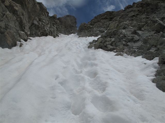
Lynn opted for the grippy rocks on the right side of the couloir, while I went with the snow (I am still a bit surprised the couloir was rated Class 2). Since we both were using our hands, it was probably closer to Class 3 at least, and this not factoring in the exposure.
topping off on the couloir
Upon topping off on the couloir Lynn firmly stated her position - she wanted to gain the ridge. Grudgingly, I followed her, thus regaining the Class 4 section approximately 1/3-1/4 from the top.
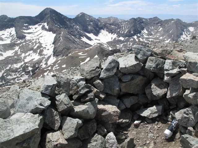
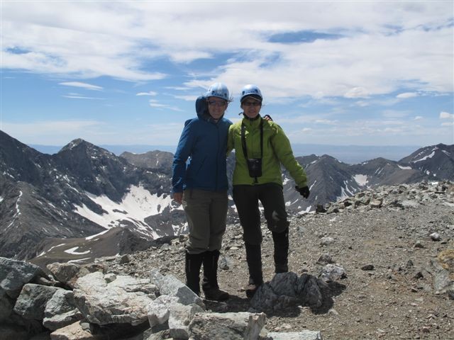
I forgot to mention that winds picked quite a bit at this point, so let's just say, the climb up North Lindsey was "interesting". Still, there were good options to hide from the gusts behind the rocks on the left side. We got to N. Lindsey, but were hartbroken to see that the Lindsey proper was still maybe 0.2 ahead of us. We finally got to Mt. Lindsey at about 2.30pm and happily found a shelter to hide from strong winds.
We were cautiously optimistic that without losing the standard trail on the way back, the return trip should take a bit less than 9 hours. We were right! Upon carefully descending the standard route from Lindsey and narrowly avoiding being thrown on the rocks by wind gusts on the connecting saddle, we safely escaped into the cozy confines of the well-marked Class 1 trail. For two and a half hours were wondering where the initial turn-off was that we so badly missed, until we bumped into the Huerfano river crossing again, the same one as in the morning, only even more powerful at this late, post-5pm time of the day. With our boots sufficiently soaked from all the snow traverses that we've done that day, we did not waste any more time and attempted to walk on water without getting wet. Unfortunately we did not succeed at that, but luckily, the car with dry socks and shoes was a mere mile away. Overall, a great day with an awesome hiking partner, and honestly, I don't regret that much being lost. I think we have found a great new route up on Mt. Lindsey, definitely a more scenic one!
Thumbnails for uploaded photos (click to open slideshow):
What a TR Natalie, glad you and Lynn made it back safe. That is a very long day when you are not expecting it. Thanks for the report, I'm planning on hitting up Lindsey sometime this summer. Congrats on making the summit!
This is what summer is all about getting lost and finding yourself in one of the greatest parts of the state(having fun too). Both of you are hiking great this year!!!
I'm heading down there tomorrow for Lindsey and Huerfano, I think I'll just go with the standard route instead of your scenic tour. Great perseverance!
Glad you two made it to the top, and at least you didn't have to negotiate the creek crossing on the way up :D We decided to hold off until possibly this weekend to shoot for Lindsey.
Fantastic job of describing a situation most of us have found ourselves in: somehow lost/turned around on a 14er trek. Really enjoyed reading this TR, and loved the photos!
missed the turn as well my first time up there and ended up at the base of Blanca. Thankfully the winds were howling hard enough to give up on any further push up the route you guys went
How much snow is there left in the coulior? Could there still be a rewarding snow climb to the top?
Excellent report, pictures, and report title! As someone said, way to persevere. Sounds like both kept a positive outlook and just adapted and took in the scenery while you chugged along!
Hey Natalie, I have an idea, let's just point our fingers in the direction of our next mountain and start hiking!! ;) can't wait until our next adventure. And btw, thanks for being such a fabulous hiking partner - I love that you push for the summit while helping me to remember to enjoy each moment.
My friend and I were laughing reading your trip report and looking at your pictures because we had a similar experience to yours. Congratulations on your perseverance!
Little Bear SW ridge route was a GRIND, but this route was FUN. I liked that the most difficult stuff was early in the day, Lindsey summit was on autopilot, and the descent was nice and easy. I could not have planned this any better myself. :P
Caution: The information contained in this report may not be accurate and should not be the only resource used in preparation for your climb. Failure to have the necessary experience, physical conditioning, supplies or equipment can result in injury or death. 14ers.com and the author(s) of this report provide no warranties, either express or implied, that the information provided is accurate or reliable. By using the information provided, you agree to indemnify and hold harmless 14ers.com and the report author(s) with respect to any claims and demands against them, including any attorney fees and expenses. Please read the 14ers.com Safety and Disclaimer pages for more information.
Please respect private property: 14ers.com supports the rights of private landowners to determine how and by whom their land will be used. In Colorado, it is your responsibility to determine if land is private and to obtain the appropriate permission before entering the property.


")
")
")
")
")
")
")
 The Ellingwood Point must be on the right (or left?)")
 wait, which one is EP? Left or right?")
")
 wowza")
")
 Here is the correct mountain")
 On top of the Lindsey-Blanca traverse")
 Going up?")
 or down?")
")
")
 This is the gulley we downclimbed into. It turned out a bit steep.")
")
")
")
")
 Started on the right of the ridge, finished on the left")
")
")
 topping off on the couloir")
")
")
")