Download Agreement, Release, and Acknowledgement of Risk:
You (the person requesting this file download) fully understand mountain climbing ("Activity") involves risks and dangers of serious bodily injury, including permanent disability, paralysis, and death ("Risks") and you fully accept and assume all such risks and all responsibility for losses, costs, and damages you incur as a result of your participation in this Activity.
You acknowledge that information in the file you have chosen to download may not be accurate and may contain errors. You agree to assume all risks when using this information and agree to release and discharge 14ers.com, 14ers Inc. and the author(s) of such information (collectively, the "Released Parties").
You hereby discharge the Released Parties from all damages, actions, claims and liabilities of any nature, specifically including, but not limited to, damages, actions, claims and liabilities arising from or related to the negligence of the Released Parties. You further agree to indemnify, hold harmless and defend 14ers.com, 14ers Inc. and each of the other Released Parties from and against any loss, damage, liability and expense, including costs and attorney fees, incurred by 14ers.com, 14ers Inc. or any of the other Released Parties as a result of you using information provided on the 14ers.com or 14ers Inc. websites.
You have read this agreement, fully understand its terms and intend it to be a complete and unconditional release of all liability to the greatest extent allowed by law and agree that if any portion of this agreement is held to be invalid the balance, notwithstanding, shall continue in full force and effect.
By clicking "OK" you agree to these terms. If you DO NOT agree, click "Cancel"...
So it is the weekend and had the itch to get some altitude! The previous weekend I met up with Matt (Matt Lemke) for the first time as we attempted to hike up Mt. Adams and successfully made it up Silverheels. After learning many lessons that weekend I was ready for my next adventure in the mountains. Matt and I discussed hitting up Blanca/Ellingwood Point the previous weekend so we decided now was the time.
Friday night I met Matt in Ft. Garland at around 6 PM and we had some pizza at All Gon's. We then headed out for the road to lead to Lake Como. After reaching the parking area at 8K we got our packs ready and started heading up the road at 7:30 PM. Now I knew from all the reading the road would gain 4K in elevation in 5.25 miles, which seems like a lot, and is! Of course it seems like an eternity when you are carrying 40+ lbs on your back and hiking a lot of it in the dark.
Here is a cool pic of the sunset as we are going up the road on 6/3.
After hiking for 4 hours we found a spot to pitch the tents and went to bed around 12 AM. We set the alarm for 5 so we could eat breakfast and be going by 6. The 5 hours just flew by and the alarm went off, Matt made oatmeal and I had a protein bar and we were going by 6:10. So just as we were getting started Matt and I were betting how much futher away we were from the lake, he said about 10-15 minutes, I guessed 5-10 minutes...2 minutes later we were there. We both got a good laugh out of it when we hit the lake so quickly. I was happy with where we pitched the tents anyway it was surrounded by trees which was nice since that evening it was pretty windy out.
After hiking for about 20 minutes we caught our first glimpse of Ellingwood Point.
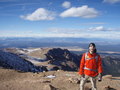
As Matt and I were talking I had metioned to him I knew of 2 other people that were doing the same 2 peaks as us, Sylwia and Jay. After about 40 minutes of hiking we ran into them. I had a nice chat with Jay, sorry Sylwia we didn't get much chance to talk, and Matt kept going. After Jay and Sylwia stopped for a break I could see Matt nearing the ridge going towards Blanca. I parted ways with Jay and Sylwia when they met up with a couple they knew and began my attempt to catch up to Matt. Here is a picture of the summit of Blanca.
After working my way up a large snowfield I got over to the talus as quickly as I could, this was my first mistake. If I would have stayed on that snowfield I would have ran right into the trail, but because I bailed I never found the trail again. So instead I hiked/crawled up all the lose talus and scree for almost 1.2K ft and by the time I hit the ridge I was only 300 ft from the summit. This is where I ran into Matt as he was working his way down and going over to Ellingwood with 2 other hikers. I was spent at this point and told him that Blanca was going to be it for me today...a decision that I am not regretting. We agreed we would meet up back at the tents and parted ways. So about 10 minutes later I was at the summit enjoying the views, this was around 10:30 AM.
Ellingwood Point
Little Bear
Lake Como
Here is my summit shot!
After resting up, taking pictures, and talking to fellow hikers from Colorado Springs for about 30 minutes I decided it was time to head back down. Looking down the trail I can see where I made my mistakes and followed the actual trail back down to the tents. I was able to shave off some time by glissading down a couple of the snow fields and because I lugged my snowshoes up all that road and to the summit I pulled them out to cross 1 snow field. Here is a pic of a waterfall I saw on the way down.
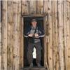
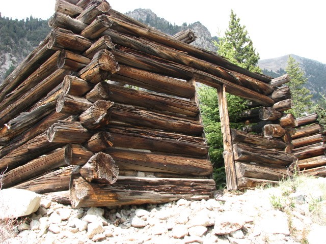
Eventually Matt caught up to me and said he needed to get his shoes off and dry off his feet so he kept on moving and I arrived back at the tents around 1:15 PM. We sat around and chatted about the day and then packed up camp. We headed back down the road around 2 PM and were back at the cars around 5:10 PM. Here is a pic of an old cabin we saw on our way down the road.
In closing I learned a lesson on how to pack better and lighter for these quick overnight trips. It makes for a long day(s) when you are carrying extra weight that really wasn't necessary.
So as for my title for the road...The Devils Armpit. I got that because the road is long, hairy in some spots, and it is a stinker to climb! Next time I will take a helicopter to the lake...I wish.
Ellingwood...I'll be back!
Hike on!
Thumbnails for uploaded photos (click to open slideshow):
Yeah summer has come at least in some of the ranges. It seems like most of the Sangre's are pretty well melted out right now. Different story however it seems in the Sawatch.
The road is clear of snow. If you have a highly modified jeep and knew how to drive it you can get aweful close to the lake. Even if you had a jeep with solid clearence you can at least make it 2 miles from the lake before the first jaws. I hope that helps!
Very appropriate title for that d*mn road - not one I want to repeat. It's funny you mentioned Jay and Sylwia, I've been climbing with them for about 9 months or so - nice couple. Nice to meet you, Heather, and ??? on Pikes Peak yesterday. Climb On!
Caution: The information contained in this report may not be accurate and should not be the only resource used in preparation for your climb. Failure to have the necessary experience, physical conditioning, supplies or equipment can result in injury or death. 14ers.com and the author(s) of this report provide no warranties, either express or implied, that the information provided is accurate or reliable. By using the information provided, you agree to indemnify and hold harmless 14ers.com and the report author(s) with respect to any claims and demands against them, including any attorney fees and expenses. Please read the 14ers.com Safety and Disclaimer pages for more information.
Please respect private property: 14ers.com supports the rights of private landowners to determine how and by whom their land will be used. In Colorado, it is your responsibility to determine if land is private and to obtain the appropriate permission before entering the property.


")
")
")
 Ellingwood Point")
 Little Bear")
")
 Lake Como")
")
")
")