Download Agreement, Release, and Acknowledgement of Risk:
You (the person requesting this file download) fully understand mountain climbing ("Activity") involves risks and dangers of serious bodily injury, including permanent disability, paralysis, and death ("Risks") and you fully accept and assume all such risks and all responsibility for losses, costs, and damages you incur as a result of your participation in this Activity.
You acknowledge that information in the file you have chosen to download may not be accurate and may contain errors. You agree to assume all risks when using this information and agree to release and discharge 14ers.com, 14ers Inc. and the author(s) of such information (collectively, the "Released Parties").
You hereby discharge the Released Parties from all damages, actions, claims and liabilities of any nature, specifically including, but not limited to, damages, actions, claims and liabilities arising from or related to the negligence of the Released Parties. You further agree to indemnify, hold harmless and defend 14ers.com, 14ers Inc. and each of the other Released Parties from and against any loss, damage, liability and expense, including costs and attorney fees, incurred by 14ers.com, 14ers Inc. or any of the other Released Parties as a result of you using information provided on the 14ers.com or 14ers Inc. websites.
You have read this agreement, fully understand its terms and intend it to be a complete and unconditional release of all liability to the greatest extent allowed by law and agree that if any portion of this agreement is held to be invalid the balance, notwithstanding, shall continue in full force and effect.
By clicking "OK" you agree to these terms. If you DO NOT agree, click "Cancel"...
Our plan for a "Sibling Summit" (ages 76 and 67) turned out to be a great, scenic, and often hilarious 12 mile hike. (Hilarious because of my brother's continuous jokes and sarcasm). We came up short of summiting. We looked up at the last mile or so and were almost horrified. Based on our speed so far, we were sure it would take a long time, and we would reach the peak far too late to return to the trailhead before sunset. A ride down from the summit was an option for me but not for my brother. My husband (not capable of hiking) was available in our town (Cañon City), about an hour and a half drive to the toll road, with a pass in hand, for my call at any time to pick us up at Devil's Playground. We hiked all the way back down. Lowell's right knee gave out at the last quarter mile back to the cars. I got a headache, not from altitude so much as a lack of coffee all day. We met a nice young college man on the way down, who had a little knee problem himself. We shared some good conversation and advil.
Here's a little recap of the hike:
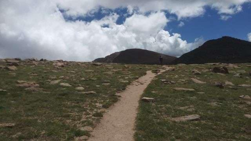
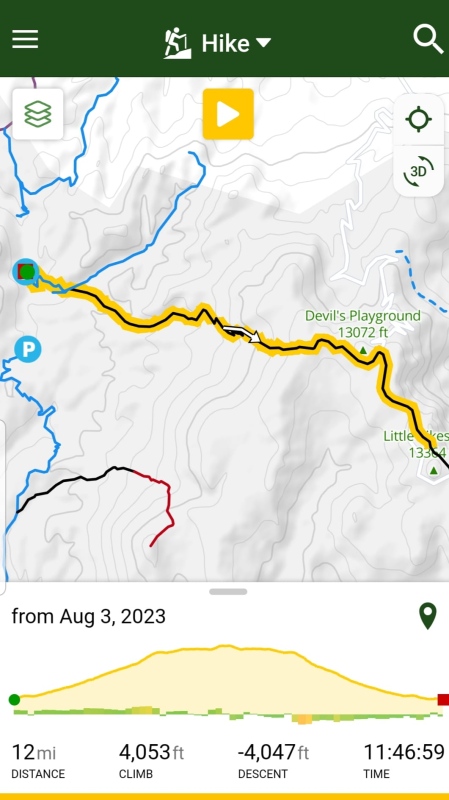
Parked at 6:00 AM. It was 47 degrees. Started hike 6:38 AM after a photo at the sign. We reached the fork to go left to Crags or right to Pikes Peak at about .60 mile, at 6:58 AM. Easy stream crossing at 1.75 miles. The optimistic plan was to reach Devil's Playground by 10:00 AM, but it was actually at 11:50. We realized then that our hiking speed was of the senior division. Our hike to Devil's Playground from Crags trailhead was 4.84 miles, per the TrailForks app on my phone. We had a break at DP and continued across the road and up the trail for a little over a mile. It sure seemed longer than that. At 5.96 miles, we arrived next to the 13er Little Pikes, and looked ahead at the summit of Pikes. Knowing we had a boulder field to challenge us at the top, we decided to call it at that point. We were back to Devil's Playground at 1:54, ate some more, and started back down at 2:10. We got some sprinkling at 2:30 that lasted most of the decent. We reached the cars at 6:25 PM. It was a 12-hour day without a summit to claim. I told Lowell we did 6/7ths of Pikes, but that was no comfort. It would have been his fourteenth 14er, and my sixteenth 14er.
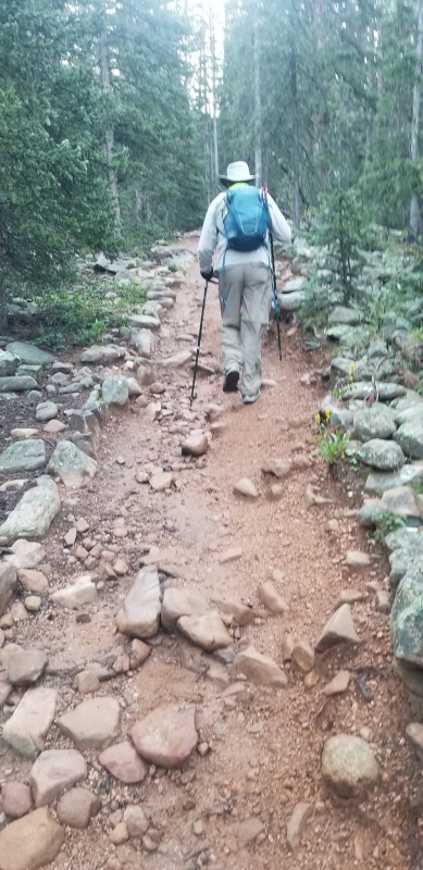
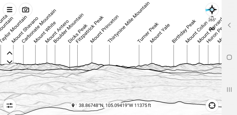
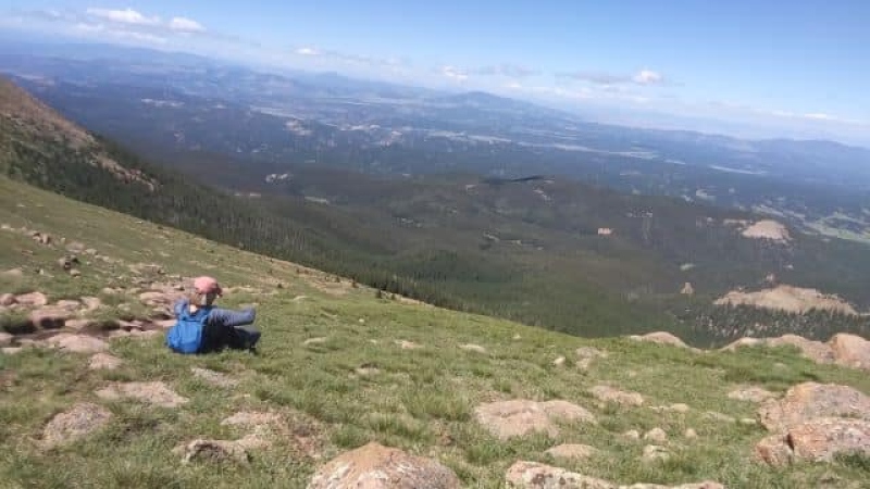
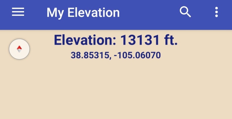
The trail head at 6:30 AMMy brother Lowell near the beginning of the hike.Screenshot from the Peak Finder appAnother screenshot from Peak FinderMe taking a break.Hiking towards Pikes after Devil's Playground.Where we turned around - adjacent to 13er Little Pikes. Pikes Peak in the center of the picture.Screenshot of our turn-around elevation.The three of us returned to the trailhead at 6:25 PM. My brother and his knee brace.TrailForks app recording. 12 miles and over 4,000 feet gained!
Thumbnails for uploaded photos (click to open slideshow):
This is the kind of trail report that I enjoy reading - thank you. Nice details to help me and others better prepare for this monstrous mountain. Your report I am sure is only touching the tip of what you encountered, yet was enough to explain both the joys and sorrows of such an endeavor. An off-note here: the Forest Service USDA.gov website map of Crags T.H. shows the parking lot about 10,000', and your gain was over 4,000' so must have been very close to the top when you decided to turn back, and yet I know GPS is often not quite right on for all devices.
I've been up that route about 30 times. (Only live about 20 minutes from the Crags TH.) I don't use apps. But that route has very few ups and downs, so the net gain/loss should be very close to the gross gain/loss. The elevation where you turned around is probably pretty close to what your phone said - 13,131'. About 3,100' higher than the TH. Don't know how the app came up with 4,000+ foot gain/loss.
Great accomplishment. I hope I can still get out of my car at the Crags TH when I am in my 70s!
We questioned the elevation at the trailhead. The website says it's 10,000, which would put us over 14,000 if we had gained over 4,000'. Yeah, didn't seem right.
Mark, I am impressed that you have "been up that route about 30 times"!! My thought was why would anyone try it more than once - it is SO difficult. You 'da man!
I am so glad I met you and Lowell on the trail! You both added to my huge joy for the day. I loved our conversation on the way down. Thanks for the advil too! My trip down would have been a lot less fun without. Hope to see you both on the trail again sometime!
Yes, we had some good conversations on the way down, and you really helped make that journey a lot more tolerable for me - thanks for carrying my pack and staying with me while my sister went for my knee brace! You were a true joy to hike with on that mountain, and maybe we will meet on another mountain in the future
Caution: The information contained in this report may not be accurate and should not be the only resource used in preparation for your climb. Failure to have the necessary experience, physical conditioning, supplies or equipment can result in injury or death. 14ers.com and the author(s) of this report provide no warranties, either express or implied, that the information provided is accurate or reliable. By using the information provided, you agree to indemnify and hold harmless 14ers.com and the report author(s) with respect to any claims and demands against them, including any attorney fees and expenses. Please read the 14ers.com Safety and Disclaimer pages for more information.
Please respect private property: 14ers.com supports the rights of private landowners to determine how and by whom their land will be used. In Colorado, it is your responsibility to determine if land is private and to obtain the appropriate permission before entering the property.


")
")
")
")
")
")
")
")
")
")


