Download Agreement, Release, and Acknowledgement of Risk:
You (the person requesting this file download) fully understand mountain climbing ("Activity") involves risks and dangers of serious bodily injury, including permanent disability, paralysis, and death ("Risks") and you fully accept and assume all such risks and all responsibility for losses, costs, and damages you incur as a result of your participation in this Activity.
You acknowledge that information in the file you have chosen to download may not be accurate and may contain errors. You agree to assume all risks when using this information and agree to release and discharge 14ers.com, 14ers Inc. and the author(s) of such information (collectively, the "Released Parties").
You hereby discharge the Released Parties from all damages, actions, claims and liabilities of any nature, specifically including, but not limited to, damages, actions, claims and liabilities arising from or related to the negligence of the Released Parties. You further agree to indemnify, hold harmless and defend 14ers.com, 14ers Inc. and each of the other Released Parties from and against any loss, damage, liability and expense, including costs and attorney fees, incurred by 14ers.com, 14ers Inc. or any of the other Released Parties as a result of you using information provided on the 14ers.com or 14ers Inc. websites.
You have read this agreement, fully understand its terms and intend it to be a complete and unconditional release of all liability to the greatest extent allowed by law and agree that if any portion of this agreement is held to be invalid the balance, notwithstanding, shall continue in full force and effect.
By clicking "OK" you agree to these terms. If you DO NOT agree, click "Cancel"...
Beta: Amphitheater Trail, Route Above Green Wall & Other Thoughts
Here are some bits of beta that I would have liked to know before I climbed Pyramid. My research was not comprehensive, so this might be repeating a trip report that I didn't read
Amphitheater Trail.
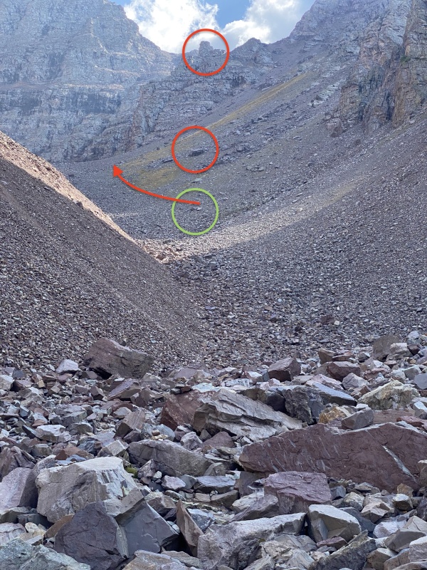
This exists, but it is a 350ft talus hop from the 4 cairns at the entrance of the amphitheater to the beginning of the trail, which runs up along the line where the cushion vegetation gives way to predominantly gray rock.
To find the beginning of the trail, when you get to the low point where you can see the whole amphitheater look for the square topped prominence on the ridge with an obvious large square boulder below it on the talus slope and head towards that. As you get closer 2 smaller boulders will come into view. The trail starts by them.
view as you enter the amphitheater proper.Closer to the start of the trail
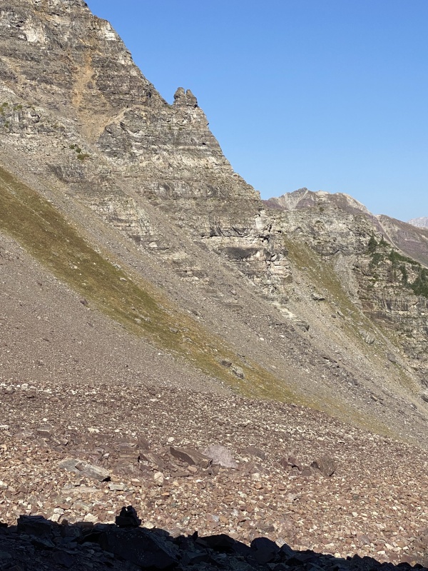
On the return from the bottom of the saddle descent, head across the rock glacier towards the prominent fork-topped spire on the far ridge line. It’s a little up and down, but eventually you will see the cairn that marks the descent into a small gully which had water running under the rocks. The trail starts after you climb out of this gully onto the predominantly gray rock. It is a pleasant walk down after the steep drop from the saddle!
While the trail is visible on the descent from the saddle it can't be seen from the bottom. Head towards the spire with a two-pronged top.
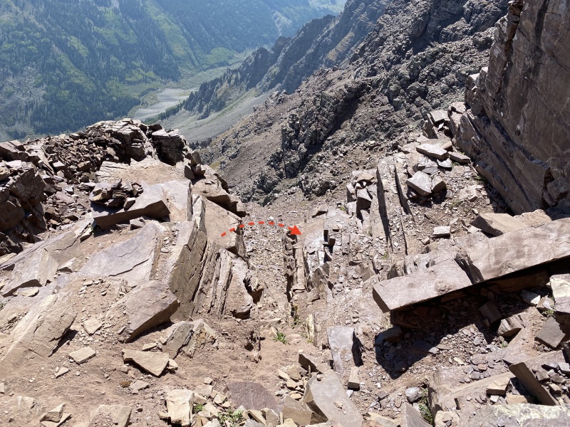
The Final 500ft.
The final climb after the Green Wall causes plenty of navigation problems. “Go left but not too far left” and "There are cairns all over the place" seem to sum up most of the beta I read.
I met a guy at the saddle who was returning defeated by this section. Having gone up and down I would describe it to him like this:
Think of this as a face. On your right (going up) is the ridge proper, the lower part of which is the top of the Green Wall. To the left around the corner of the face are steep cliffs. This face gets narrower at the top. You cut left off the green wall to get into the center of this face. Then switch back your way up the ledges. I walked to the left to point I didn’t want to go any further then I back tracked 30-40 ft and worked my way up.
Eventually, I got to a point where I could see the gully leading to the summit. Some beta had mentioned this was the easiest approach, so I cut across a flattish area of particularly thin, flakey maroon rock to try go up that gully. But I had to ascend a class 4 wall. I could have continued up the class 3 face to by-pass this wall.
About 100ft below the summit the face hits a small head wall: This is the ridge turning in towards the summit. The trail follows along the base of this, above the gully and towards the summit.
It's easy to figure out on the way down, but I never found a sufficiently detailed description in my research, which is not to say it isn't there somewhere.
Other Points:
I agree with those you say don't take the shortcut to the right near the top of the saddle. Doesn't look fun and scooting up to the saddle and along the trail is probably quicker anyway.
I climbed up the right of the green wall behind a small rock rib and next to the trail some people have mentioned. I saw the trail on the maroon sandstone, but the green wall was nicer rock. I only mention this because on my descent a goat sent a large rock flying down the center of the green wall. Climbing to the right of the rock rib would provide some protection from that.
As I worked up to the leap of faith ledges I followed some cairns that took me too high, to a large rock that would obviously have rated a mention in the trip report had it been on the route. Cairns lead around either end of the rock. The near end connected you to the trail leading to the leap of faith. The far end went through a crack that eventually became the leap of faith gully. I was able to descend to the left and jump the leap of faith, but I could see how you could descend to the right and avoid the leap if you wanted to.
If you really wanted to avoid the leap you could work down the ledges to the right. As someone who is a bit of a wimp, but growing more confident, the leap was quite comfortable as you have a flat takeoff and landing zone on either side.
Thumbnails for uploaded photos (click to open slideshow):
I'd definitely check out the leap first. I think it is probably worse in anticipation than reality, but we all have our own quirks.
Caution: The information contained in this report may not be accurate and should not be the only resource used in preparation for your climb. Failure to have the necessary experience, physical conditioning, supplies or equipment can result in injury or death. 14ers.com and the author(s) of this report provide no warranties, either express or implied, that the information provided is accurate or reliable. By using the information provided, you agree to indemnify and hold harmless 14ers.com and the report author(s) with respect to any claims and demands against them, including any attorney fees and expenses. Please read the 14ers.com Safety and Disclaimer pages for more information.
Please respect private property: 14ers.com supports the rights of private landowners to determine how and by whom their land will be used. In Colorado, it is your responsibility to determine if land is private and to obtain the appropriate permission before entering the property.


")
")
")
")
")
")