Download Agreement, Release, and Acknowledgement of Risk:
You (the person requesting this file download) fully understand mountain climbing ("Activity") involves risks and dangers of serious bodily injury, including permanent disability, paralysis, and death ("Risks") and you fully accept and assume all such risks and all responsibility for losses, costs, and damages you incur as a result of your participation in this Activity.
You acknowledge that information in the file you have chosen to download may not be accurate and may contain errors. You agree to assume all risks when using this information and agree to release and discharge 14ers.com, 14ers Inc. and the author(s) of such information (collectively, the "Released Parties").
You hereby discharge the Released Parties from all damages, actions, claims and liabilities of any nature, specifically including, but not limited to, damages, actions, claims and liabilities arising from or related to the negligence of the Released Parties. You further agree to indemnify, hold harmless and defend 14ers.com, 14ers Inc. and each of the other Released Parties from and against any loss, damage, liability and expense, including costs and attorney fees, incurred by 14ers.com, 14ers Inc. or any of the other Released Parties as a result of you using information provided on the 14ers.com or 14ers Inc. websites.
You have read this agreement, fully understand its terms and intend it to be a complete and unconditional release of all liability to the greatest extent allowed by law and agree that if any portion of this agreement is held to be invalid the balance, notwithstanding, shall continue in full force and effect.
By clicking "OK" you agree to these terms. If you DO NOT agree, click "Cancel"...
I have done variations on this trip report a couple times already. I am adding this one because it will provide detailed mileage and times. I am not very high tech, but I did carry a gps along with pad and paper to make notes along the way marking distance at key waypoints. On this trip I started at the Silverpick (Rock of Ages) trailhead. At just over a mile from the trailhead I took the Elk Creek trail south, passing the Woods Lake trail and eventually joining the Navajo Lake trail. Just when the Navajo Lake trail levels out I left the trail, crossed the creek and started up the long ugly talus slope to the West Ridge of El Diente. After climbing El Diente and traversing to Mt. Wilson, I hiked down the North Slopes to once again intersect the Navajo Lake trail and hike up to Rock of Ages Pass and then down to the start. This took 12h 20m. I burned about 30 minutes or more losing the trail on the North Slopes even though I have done this several times, both up and down. My only advice here is make sure you don't begin dropping down too soon. When in doubt, move to the north and descend close to the Wilson Glacier.
I think this would be a good route for someone interested in knocking all three peaks done in one day without camping. You get to the Rock of Ages pass and are less than 5 miles from your car and can easily gauge if you have the time and/or energy to go for Wilson Peak before heading out.
Intro out of the way, here is the down and dirty of this hike:
9:00 a.m. start.
9:30 a.m./1.22 miles intersection with Elk Creek Trail
Elk Creek/Rock of Ages trail junction
10:30 a.m./mile 3.75 Woods Lake trail junction. The Elk Creek trail is a nice alternative to Woods Lake. It is about a mile longer to get to Navajo Lake this way, but it starts about 1,000' higher up and is a much prettier hike.
Elk Creek/Woods Lake trail junction
11:00 a.m./mile 5.0 Junction with Navajo Lake trail
Woods Lake/Navajo
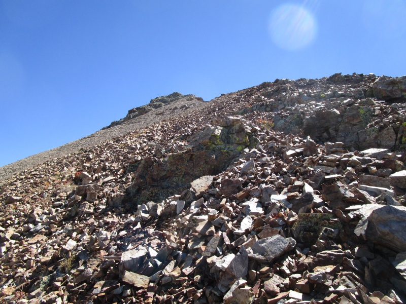
Getting up to the West Ridge of El Diente can be a real bear. On this trip, it didn't seem like the hell it had been in past efforts. Best advice I have here is leave the Navajo Lake trail as soon as it levels out. There is a faint trail leading to an old and seldom used campsite. A fire ring and some trash. From there head to the creek and find a crossing. East to keep feet dry when the water is low, as it is now. Work your way out of the trees and gaze on your next hour of effort. Work along the tree line to the highest point where trees grow. Spot a tower of rock just west and high above that point. Getting to the bottom of the cliff and then working right, climbing "solid" rock when possible worked well. I was off the nasty bit in about 45 minutes.
Noon/mile 6.0 Crest of the West Ridge
Looking back at where Woods Lake trail drops down to join Navajo Lake trail.
Hike on the ridge for about an hour to reach a false summit, where the first view of the fun ahead comes into view.
False summit
1:00 p.m./ mile 6.8 False summit reached.
View of El D from false summit
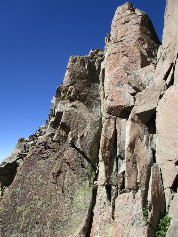
1:50 p.m./mile 7.6 The first crux
Getting near the 1st crux
1st Crux
Look for a cairn on the left in the shadow on the big rock platform. Don't try to drop down to it too soon. Climb up past the first obvious gap and then do a sporty and exposed downclimb. One hard move and then it immediately eases up. Regain the ridge and carry on.
Looking back at the 1st Crux after regaining the ridge
2:15 p.m./mile 7.8 The 2nd Crux
Looking back at the 2nd crux after downclimb
The 2nd crux is a downclimb to a notch that marks the beginning of the final push to the summit. This looks harder than it is and I think the first crux is the more technically difficult. Short people may disagree. The move requires downclimbing the crack in the center of the previous photo. There is actually room in there to do a bit of stemming. Once down in this notch the view ahead is daunting. But take heart, the difficulties are behind you now. The climbing from here to the summit is gymnastic and fun and nothing comes close to the technical climbing required to get here.
View ahead after 2nd Crux. Just head straight up!
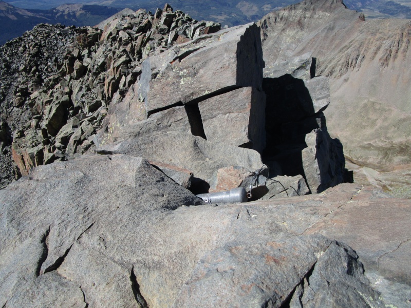
2:50 p.m./mile 8.2 Summit El D.
Summit Register canister has no cap and is empty
4:50 p.m./mile 9.6 Summit Mt. Wilson
El Diente from the summit of Mt. Wilson
6:30 p.m./mile 10.8 Regain Navajo Lake trail
Looking up at Rock of Ages pass after getting off North Slopes of Mt. Wilson
7:15 p.m./mile 11.7 Rock of Ages Pass
North Slopes of Mt. Wilson from Rock of Ages Pass
8:50 p.m./mile 14.8 Rock of Ages/Elk Creek trail junction
Elk Creek trail, where I started 12 hours earlier
9:20 p.m./mile 16 Back at truck.
Thumbnails for uploaded photos (click to open slideshow):
My friends and I glassed the West Ridge of El D from both the Kilpacker and Navajo Basins in July, and we were curious if it was viable. Now we know it goes! Looks like a pretty sweet ridge once you get on it, but I'm assuming there is a sufferfest of bushwhacking to get there.
How's the rock quality? Having been on both the north and south sides of El Diente I can't imagine the west ridge is any good but the photos make it look alright!
Kinda late to the party here, but then the mountain ain't going anywhere in our lifetime. So we are headed there next week to do West ridge but ascend from Kilpacker Creek side, which looked like a grassy and tight scree stroll last time I came down the trail. We would start just beyond where you cross Kilpacker Creek, to get the most shallow slope. Thanks for real pictures of the crux areas, which fill in the gaps of Prinner's report found elsewhere. Not sure I want to publicize this route much, given what the Millenials have done to the standard Kilpacker ascent, which is now a killer rock chute. I'll add some comments to the North Buttress posts, since this one did not even pop up under El Diente when I looked.
Hey medunham. I have done the west ridge several times, and once up the grass from Kilpacker. Since I live in Montrose, the drive make the Navajo Basin easier to reach. But for that, I would prefer the approach from the south, as you intend. Good luck, have fun. It takes a long time to gain the ridge, but the grass in just nicer to walk on than the scree on the other side.
Caution: The information contained in this report may not be accurate and should not be the only resource used in preparation for your climb. Failure to have the necessary experience, physical conditioning, supplies or equipment can result in injury or death. 14ers.com and the author(s) of this report provide no warranties, either express or implied, that the information provided is accurate or reliable. By using the information provided, you agree to indemnify and hold harmless 14ers.com and the report author(s) with respect to any claims and demands against them, including any attorney fees and expenses. Please read the 14ers.com Safety and Disclaimer pages for more information.
Please respect private property: 14ers.com supports the rights of private landowners to determine how and by whom their land will be used. In Colorado, it is your responsibility to determine if land is private and to obtain the appropriate permission before entering the property.


")
")
")
")
")
")
")
")
")
")
")
")
")
")
")
")


