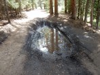
5/27/2025 Posted On: 5/27/2025 By: LetsGoMets Info: 390 is dry all the way to Winfield. 4x4 road is clear of snow all the way to TH. Also climbed up Lulu Gulch TH - clear to about 11.5k where deep soft snow drifts are continuous. From a distance on the CDT looking at Huron/ Browns there is still a lot of snow in the gulch and signs of recent slides. | ||||
5/4/2025 Posted On: 5/5/2025 By: jennincolorado Info: Easy and very dry to Winfield. Lots of people out camping in their RVs. Can drive about 3 minutes past Winfield up the Huron 4wd TH road before you hit a decent amount of snow. That's where we turned back in our 4x4 Chevy Trail Boss. Would not recommend going further. It may snow up there over these next few days with this odd storm system, but I imagine it will melt out very quickly. The area is VERY dry for this time of year. | ||||
12/23/2024 Posted On: 3/31/2025 By: jacolc Info: Barely drive in SUV AWD to Winfield on Dec 21. Was stuck 2 times 0.3 and 0.2 miles below. But shoveling off was fast 3-6 min, snow on the side of track was only 6-10' deep. On the way down on Dec 23 was stuck only one time just below Winfield. Drive slowly and stick exactly to existing track. And have the shovel. Edited 3/15/25 | 1 |
|||
10/26/2024 Posted On: 10/26/2024 By: d_baker Info: Still accessible, and Suburable -- saw a Crostrek there this morning. | ||||
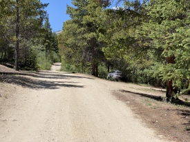
9/7/2024 Posted On: 9/7/2024 By: ConnorLewGym Info: The 390 road has tons of dispersed camping options all along the road. Its 12 miles of dirt road to Winfield and gets progressively worse (worse = more potholes and more rocks) ... any car can make it to Winfield, its not tough, just rough. Just past all the stuff at Winfield is a big camping area and then the 4WD road starts. We went about .4 miles up the 4WD road in a Subaru Outback and pulled off to camp the night before (lots of additional pull of spots all along the 4WD road and there's a good camping around about half a mile from the 4wd trailhead). Looked like we probably could have made it as we hiked in the next morning -- a small creek crossing, and a couple bigger obstacles that can be crossed with a Subie, but hard to know that ahead of time. At the 4WD trailhead was mostly trucks / 4runners / big SUVs with one Rav4, a couple outbacks and a Forrester Sport. | 1 |
|||
8/27/2024 Posted On: 8/27/2024 By: Joek4au Info: Drove the 4WD trail to the upper trailhead in a stock wrangler rental on 8/27/24. There were mud puddles but no real mud. There was an outback, Ram, and F150 in the lot as well. No issues with the route. | ||||
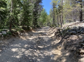
8/6/2024 Posted On: 8/6/2024 By: mkauf90 Info: I hiked Huron Peak on 8/5. According to some other folks, there has been repair work done on the 4WD road to the upper trailhead. I had no trouble at all with driving up to it in my 2015 Mazda CX-5 with an aging suspension. Just took my time and picked my lines. (I probably wouldnt do it with a small sedan like a Nissan Sentra, though!) Great hike! | 2 |
|||
8/4/2024 Posted On: 8/4/2024 By: AurumSun13 Info: I hiked Huron on 8/3/24. CR 391 is a gravely dirt road with some pot-holes here and there, but my Nissan Sentra was able to make it to the lower 2WD TH without issue. Walking along the 4WD to the upper TH I noticed much larger dips/ruts that a car, like mine, without high clearance would struggle with. Nevertheless there are a plethora of pull outs and campsites along the road from Winfield all the way up to the actual 4WD TH. Just pick an open spot before you reach a point where your car can't go any farther and you'll be fine. The trees provided my car with plenty of shade during the day, too. | 1 |
1 |
||
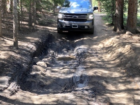
7/22/2024 Posted On: 7/22/2024 By: Skimo95 Info: They repaired the dugout section at the beginning. This is probably the best condition Ive seen the road in 4+ years. If youve ever been on the fence with a rwd pickup or Subaru Id say nows your chance. The trail is in great shape up to west apostle | 6 |
1 |
||
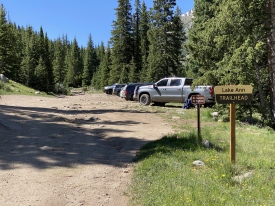
7/12/2024 Posted On: 7/15/2024 By: carmitz001 Info: Made it to the 4WD trailhead in a rented 2023 Jeep Wrangler with no problems. This road was a lot easier than Mt. Antero's 4WD road, although it still needs good clearance. The area was surprisingly busy. About eight vehicles were parked at the 4WD trailhead at 11:45 a.m. There were also several vehicles parked at pull-out spots along the 4WD road. If you don't want to drive the whole 4WD road, you can park at one of these spots and hike to the trailhead with only 100-300 feet of elevation gain. | ||||
7/6/2024 Posted On: 7/6/2024 By: bagelbattalion Info: Echoing others, the beginning component of the 4WD road is very rough. Had it been lighter out we would have attempted but ended up parking just below it and hiking in given how dark it was. 4x4 trucks, 4Runners, even a Honda CRV made it to the top. That first hill seemed to be the worst, if you're remotely experienced on a rough 4WD road it seems doable. | ||||
6/30/2024 Posted On: 6/30/2024 By: jenna33 Info: 4wd road is a lot tougher than the last time I did it. My Subaru forester made it up just fine but I was a little nervous driving! Pick your lines carefully and make sure to keep speed going up the first hill and through mud pit. If you can navigate the first hill, you will probably be fine | 2 |
|||
6/24/2024 Posted On: 6/24/2024 By: Monte Meals Info: Road to Huron TR open ( no snow ) Several Subies made it to trail head. | 1 |
|||
6/15/2024 Posted On: 6/15/2024 By: ssowalskie Info: Parked just below the start of the 4x4 road and walked the rest of the way. There were several vehicles that parked/camped along the 4x4 road, but only one vehicle actually made it all the way to the 4x4 trailhead. There was a significantly washed-out section about two-thirds of the way up the 4x4 road that kept most of the vehicles below that point, though I did see 3-4 vehicles past it. The vehicles that made it further up the 4x4 road tended to be Jeeps/4Runners/trucks, and I believe the vehicle that made it all the way to the trailhead was an XTerra. I saw a Subaru Outback Wilderness about a quarter mile past the start of the 4x4 road. I wouldn't chance the 4x4 road in a stock Subaru. Additionally, to echo what someone said a while back there aren't any restrooms at the 2WD parking area. | 3 |
5 |
||
6/1/2024 Posted On: 6/1/2024 By: daway8 Info: Road is melting fast. Bottom of the 4WD section is getting close to being dry, but don't let that fool you; it would take a very capable vehicle/driver to get all the way to the 4WD trailhead at the moment, if you even could. Most people would be much better off waiting at least another week or two before expecting to drive to the 4WD TH. |


