
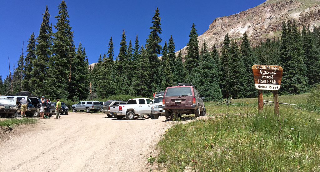
8/16/2025 Posted On: 8/16/2025 By: Mark Goldstein Info: The road conditions are in full summer swing to the upper trailhead. A couple of ruts, but manageable by high clearance vehicles. Some Subaru's made it up too! A lot of side-by-sides on the trail. The stream/water crossings were benign. The outhouse was nailed closed. Bummer. The overall road has been improved over the year. Thank you!!! | ||||
8/13/2025 Posted On: 8/13/2025 By: sherby Info: Made it with a OWB, lower clearance cars made it too, but I wouldn't recommend. | ||||
8/7/2025 Posted On: 8/7/2025 By: travisspear Info: Most AWD crossovers can do this road in its current condition. There were Subarus, rav4s, CX5s, and CRVs all present at the upper trailhead or camping close to it. Both water crossings were at most 6 inches deep and there weren't any unavoidable large rocks or ruts that would block progress. Compared to other roads in the area, this one was easier than the road to the 2WD Matterhorn Creek trailhead (10,300') and only slightly more challenging than silver creek/grizzly gulch - all driven early August 2025. | 2 |
3 |
||
7/14/2025 Posted On: 7/31/2025 By: paigemoney Info: July 13/14 post-construction update – My first time on this road, and WOW, it is PHENOMENAL. (I drive a Wrangler.) Easily the smoothest 4WD road I’ve driven in Colorado. A couple of things worth noting: the creek crossings and subsequent sharp turns are exactly as pictured and described by others. There are some large bumps—like exaggerated speed bumps with a lot of up-and-down motion. Clearance would still be helpful, I think. I never had to pick a line; the road was truly amazing. The biggest issue on this road is passing. There are pull-offs, but you’ll need to be prepared to back up to let others by. On Sunday at 3:30 p.m., there was still quite a bit of traffic coming down. There was still decent side-by-side traffic leaving Monday mid-morning. The hardest part was passing full-sized pickup trucks, but fortunately everyone was kind and did their best to move over. | 4 |
4 |
||
7/12/2025 Posted On: 7/12/2025 By: Flips Info: The maintenance on the road has improved the drivability immensely. We joked wondering when they were going to paint the center stripe. | 2 |
1 |
||
6/23/2025 Posted On: 6/23/2025 By: tdc001 Info: Updated info from the Hinsdale County Administrator: Nellie Creek Road 877, off of CR 20 in Hinsdale County, will be closed weekdays for road maintenance from June 23 through July 10th. Hinsdale County Road Crews, under agreement with the USFS Gunnison Ranger District, will be maintaining the road with heavy equipment, focusing on improved safety and drainage. NFSR 877 will be closed to vehicular use by the public Monday-Thursday 6/23-7/10. Those wishing to access the Uncompahgre Trailhead will need to plan on parking off County Road 20 at the base of NFSR 877. The road will be open for use Friday- Sunday during the maintenance project. | ||||
6/21/2025 Posted On: 6/21/2025 By: BillMiddlebrook Info: ALERT!! Starting Monday, June 23rd, 2025, the Nellie Creek road will be CLOSED Monday through Thursday for the next several weeks while Hinsdale County conducts Road Maintenance. | 1 |
|||
6/21/2025 Posted On: 6/23/2025 By: asmenyak Info: Road was sketchy but just barely doeable in our Rav4. A few bumps along the way but nothing too insane. We did stop and camp just before the first creek crossing, but later on we watched a CRV go through so it's definitely possible with the right amount of gumption, and after that it's mostly the same conditions as the bottom half if not better. Don't attempt this one in anything less than AWD, and 4WD with decent clearance is definitely preferred. Note that the bathroom at the upper trailhead seems to be boarded shut. | ||||
6/6/2025 Posted On: 6/7/2025 By: Cuttlefishette Info: Creek's running high! Hiked up 6/6. Road actually looks to be in really good shape, considering all the rain, but both creek crossings are pretty gnarly right now. One little spot of old snow, but nothing to write home about. Mud's a little rough on the way down though. Saw the same trucks and jeeps at the TH that always make it. Creek's another story. At the first crossing (~2mi), you're going straight against the current for maybe 40 feet before you hit the main creek, which gets to be about knee deep towards the left side and looked even deeper to the right. Rocks aren't too slippery or sharp if you want to barefoot it (I did, no regrets, actually not that cold) but no way to boot across without getting soaked. At the second crossing, there're a couple navigable logs a few yards upstream of the road; they're a little PG-13 when dry, but get slippery enough in the rain that I'd bump them up to an R. Campsites up top were mostly dry and mostly empty on a Friday afternoon, I recommend the little meadow at around 3.7mi. A little farther from the TH than other options, but way better views. Overall, if you're walking the creek road this season, I'd bring a towel, trekking poles, and a change of socks. | 3 |
2 |
||
2/10/2025 Posted On: 3/31/2025 By: jacolc Info: CR20 dry in 99%. Winter gated 0.3m above intersection with 4WD, 5miles from LakeC. 4WD section above CR20 well packed by skiers, snowshoers and scouts (they bivi 0.6m below upper TH). No sign of snowmobiles. | ||||
10/16/2024 Posted On: 10/16/2024 By: indyjmatt33 Info: Made it to the top in a stock 4Runner. Can honestly say this is the worst road I've driven on. Very narrow, with very sharp turns up the switchbacks. Myself, or others, had to backup several times to allow others to share the 1 lane road. Got a few pinstripes from how narrow the road is. I tapped my skid plate twice going down--likely user fault, but still difficult. Tons of side-by-sides and ATVs. Only other cars we saw were another 4Runner, Bronco, and a Jeep. | ||||
9/16/2024 Posted On: 9/16/2024 By: DrewJHartmann Info: Pretty gnarly drive; but fun and doable if you are prepared & capable! I made it to the upper trailhead in my stock Jeep Cherokee Trailhawk; I had a spotter which was tremendously helpful and didn't have any issues getting up there. Only thing is, there are very few places to pull off, so traffic can be a bit sketchy. Overall, this road is doable with 4wd, off-road experience, and high clearance; I would highly suggest having a spotter as well for when it gets tight or traffic arrives. | 2 |
|||
9/15/2024 Posted On: 9/16/2024 By: ColoNativeGal Info: Didn't think it was as bad as what I had read. Definitely need a good 4w vehicle with good clearance. Road is narrow and S curve is very tight. Would not recommend for full size truck, but did see stock F150, Tacoma, 4Runner, Jeep and I think a Tundra at the upper TH. We made it no issue in a Jeep Gladiator with 4" lift. | ||||
8/17/2024 Posted On: 8/23/2024 By: mountainero Info: Drove a 2DR JK Rubicon on metric 33's to the TH, took about 30 minutes both ways. Hard to measure the difficulty given the capability of my vehicle, but in my opinion, as long as you've got some good tires (aired down) and decent clearance you'd be fine. I thought the worst part was the off camber section at ~3 miles. It's slow, but nothing crazy and faster than walking. Saw a one ton dodge and a suburban at the TH. | 1 |
|||
7/20/2024 Posted On: 7/23/2024 By: djrey002 Info: This road is technically Subaru-able but don't think I would do it again. I made it to the top in a stock Subaru Forester Wilderness (~9.2 inch clearance) but would think you would want to have a Wilderness or modified Subaru to even attempt it. I did air down the tires to ~20 PSI, picked lines very carefully, and still scraped the skid plate in a few spots. It took about 45 minutes each way and I only had to pass a few vehicles on the way down. Creek crossings were not an issue. I was the only Subaru at the upper TH and other vehicles that I saw at the top included Tacomas, FJ's, Tundras, Wranglers, and somehow a Jeep Liberty and a Suburban. | 1 |


