This is a mountaineering forum, so please keep your posts on-topic. Posts do not all have to be related to the 14ers but should at least be mountaineering-related.
Personal attacks and confrontational behavior will result in removal from the forum at the discretion of the administrators.
Do not use this forum to advertise, sell photos or other products or promote a commercial website.
Posts will be removed at the discretion of the site administrator or moderator(s), including: Troll posts, posts pushing political views or religious beliefs, and posts with the purpose of instigating conflict within the forum.
For more details, please see the Terms of Use you agreed to when joining the forum.
FWIW, Google earth can answer nearly any question you have like this one.
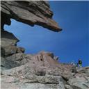
Here is your original image with the peak in question:
original.JPG
Here is a sceen cap from about the correct location from Google Earth (I didn't fuss with getting the vertical aspect quite right, but you can and it's also a little closer than yours):
one.jpg
Here is a screen cap from above complete with label. All of the surrounding peaks are also noted with green mountain icons which can be hovered over for more specific information.
2.jpg
You do not have the required permissions to view the files attached to this post.
Call on God, but row away from the rocks.
Hunter S Thompson
Walk away from the droning and leave the hive behind.
Dick Derkase
iholdthepain wrote:Interesting this topic comes up. I live a little north, in Loveland. From my house, you can see two peaks beyond the foothills, just north of where storm peak drops down, in the gap between Longs and the Mummy range. Sometimes, I've been certain they were Hallet and Otis, other times, I've thought McHenry's and Powell, but then I think those would definitely be covered by the Longs/ Storm saddle. My specific vantage point is from I-25 and US34. The southern peak looks like an ocean wave moving south, and the northern peak is a symmetrical cone. It's obviously on the divide, with a glacier between them, facing me. In my OCD, I've scoured topo maps and photos, but I've never figured it out or found the correct camera angle. From the OP's photos, the angle would be from about 20 miles straight north, but the north end of the photo stops short of Longs.
Anyone?
Does this by any chance show what you're looking for?
You do not have the required permissions to view the files attached to this post.
"But in every walk with Nature, one receives far more than he seeks."
John Muir
iholdthepain, here is the rest of the panorama past longs/meeker. Does this show what your looking for?
Image
4 by Aaron Spong Fine Art, on Flickr
the left (south) summit of Twin Sisters is actually Twin Sisters Mountain or the 'South Sister' - 11,376 ft. The two elevations you list are west and east sister (east is the higher one)
iholdthepain, here is the rest of the panorama past longs/meeker. Does this show what your looking for?
Image
4 by Aaron Spong Fine Art, on Flickr
the left (south) summit of Twin Sisters is actually Twin Sisters Mountain or the 'South Sister' - 11,376 ft. The two elevations you list are west and east sister (east is the higher one)
Thank you! This has been very helpful! And thanks for the tips on google earth and peakfinder. I definitely will be looking into these. I'd never heard of peakfinder before.
http://www.heywhatsthat.com/ is another resource. Just click your location and submit a request. The panorama view isn't that great, but it gives a lot of information.