Log In 
Photo

Bald Mountain

North Ridge
Difficulty Class 2 
Ski/Board: Intermediate, D4 / R2 / II  
Risk FactorsExposure: Moderate
Rockfall: Moderate  
Route-Finding: Moderate  
Commitment: Moderate  
 
Start10,600 feet
Summit13,703 feet
Total Gain3,300 feet
RT Length9 miles (with a start at the main trailhead), 7.5 miles (starting at pull-off up the dirt road)
Last UpdatedDec 2025
Show More
Photo

Trailhead

Drive to the south end of Breckenridge and turn east onto Boreas Pass road. Drive 2.0 miles up Boreas Pass Road and turn left on Baldy Road (520). Come to the end of the paved 520 road at 3.3 miles. Emmet Lode (536) turns left. This is the main/winter trailhead and a limited number of cars can park here. In summer, it's possible to park higher by driving up the dirt road that continues straight from the parking area. After 0.7 mile up this road, there is a small parking area on the right before the road requires 4WD.

Route Description

 1 and  2 show most of the route above tree line. The route follows the 4WD road that starts at the end of the paved Baldy road and goes all the way up to the crest of Baldy's north ridge.

From the trailhead, walk 0.7 mile up the dirt road to a small parking area on the right. Stay on the road and continue up to reach the Iowa Mill, at 11,234'. Turn left and continue up the road as it switchbacks up the gentle slope, below the north ridge. Near 11,700', the road takes a sharp left and begins the last stretch to the ridge. Continue up the road to reach the north end of the the north ridge - near 12,200'. Turn right (south) and hike up to the radio towers, near 12,580'.

After the radio towers, follow the narrow road south ( 3) until it turns into a trail, near a 12,900-foot point -  4. Beyond the 12,900-foot point, cross a brief flat section -  5. The remaining hike is up-and-down on or near the ridge crest.  
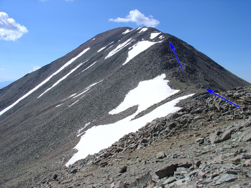
6 was taken at 13,100' and shows the remaining route to the summit. Near 13,300', climb a rough section on the right side of the ridge -  7. Continue over another hump or two to reach the final pitch, near 13,500' -  8. Follow the ridge crest to the top -  9.  10 was taken from 13,500' and looks back down on the route.

Notes

In winter, the Baldy Road is plowed to the end. The dirt road that leaves the main trailhead is not plowed. When the snow has melted, 2WD vehicles can continue a short distance up the dirt road. Good-clearance 4WD vehicles can drive all the way up to 12,000' on the start of the north ridge.

Maps

JPG Image
Static Map JPG

Interactive Map & 3D Flythrough
Human Verification Required

Photos

#1#2#3#4#5#6#7#8#9#10

Weather

Caution: The information contained in this route may not be accurate and should not be the only resource used in preparation for your climb. Failure to have the necessary experience, physical conditioning, supplies or equipment can result in injury or death. 14ers.com and the author(s) of this route provide no warranties, either express or implied, that the information provided is accurate or reliable. By using the information provided, you agree to indemnify and hold harmless 14ers.com and the route author(s) with respect to any claims and demands against them, including any attorney fees and expenses. Please read the 14ers.com Safety and Disclaimer pages for more information.

Please respect private property: 14ers.com supports the rights of private landowners to determine how and by whom their land will be used. In Colorado, it is your responsibility to determine if land is private and to obtain the appropriate permission before entering the property.
Heading to a 14er soon? Don't forget the 14ers.com mobile app.
Google Play     Apple App Store