Log In 
Elevation 14,155' (LiDAR)
Prev Elevation 14,150'
CO 14er Rank 27 of 53
Range San Juan
Forest Uncompahgre
County Ouray
Towns Ridgway, Ouray, Telluride
Mt. Sneffels

Photos

360 Pano
360° Summit Pano
pic1
pic2
pic3
pic4 pic5 pic6 pic7 pic8 pic9 pic10 pic11 pic12 pic13 pic14 pic15 pic16 pic17 pic18 pic19 pic20 pic21 pic22 pic23 pic24 pic25 pic26 pic27 pic28
pic29
pic30 pic31 pic32 pic33
pic34
pic35
pic36
pic37 pic38 pic39 pic40 pic41 pic42 pic43 pic44 pic45 pic46 pic47 pic48 pic49 pic50
pic51
pic52 pic53 pic54 pic55

Climbing Routes

route
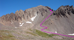
Mt. Sneffels - South Slopes Standard Route
Difficulty: Easy Class 3
Total Elevation Gain: 2,900'
Round-trip Distance: 6 mi
Exposure: Considerable
Rockfall Potential: Considerable
Route-Finding: Moderate
Commitment: Moderate
route
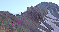
Mt. Sneffels - Southwest Ridge
Difficulty: Class 3
Total Elevation Gain: 2,950'
Round-trip Distance: 6.5 mi
Exposure: Considerable
Rockfall Potential: Considerable
Route-Finding: Considerable
Commitment: Considerable

Map

Human Verification Required

Trip Reports

  8 Recent Reports Peaks Climbed Added
  The Sneffles maze - up the ridge
By: Paul M
Peak(s): Mt. Sneffels
Added: 8/9/2026
Mt. Sneffels 8/7/2026 8/9/2026 1  44
  of chafe and character-building Google Map Included GPX file available for download
By: EvanKBlack
Added: 7/30/2026
San Luis Peak
El Diente Peak
Mt. Wilson
Wilson Peak
Mt. Sneffels
Mt. Lindsey
7/22/2026 7/30/2026 9  24
  Blaine Basin Info Google Map Included GPX file available for download
By: Wentzl
Peak(s): Mt. Sneffels
Added: 7/10/2026
Mt. Sneffels 7/9/2026 7/10/2026 4  7
  Sneffels Solo Climb
By: Kestrelrun
Peak(s): Mt. Sneffels
Added: 9/7/2025
Mt. Sneffels 8/22/2025 9/7/2025 9  8
  A Rubber Ducky View of Sneffels SW Ridge Google Map Included GPX file available for download
By: daway8
Peak(s): Mt. Sneffels
Added: 6/29/2025
Mt. Sneffels 6/28/2025 6/29/2025 15  15
  Going Downhill Even Faster
By: HikesInGeologicTime
Added: 5/13/2025
Culebra Peak
Red Mountain
Wetterhorn Peak
Mt. Lindsey
Challenger Point
Kit Carson Peak
Mt. Sneffels
9/13/2019 5/13/2025   7
  Spectacular and Horrendous - Sneffels Southwest Ridge from Blue Lakes Approach Google Map Included GPX file available for download
By: ECF55
Peak(s): Mt. Sneffels
Added: 2/12/2025
Mt. Sneffels 7/23/2024 2/12/2025 15  50
  Taking the Scenic Route up Sneffels
By: Willy the Kid
Peak(s): Mt. Sneffels
Added: 8/14/2024
Mt. Sneffels 7/31/2024 8/14/2024 22  23
View All 268 Trip Reports

Frequently Asked Questions about Mt. Sneffels

Is Mount Sneffels a good starter peak to transition to more difficult 14ers?

Yes, Mount Sneffels is one of the absolute best introductory peaks for hikers looking to transition from Class 2 trails into tougher terrain. The standard route up the South Slopes only requires a very short, manageable stretch of easy Class 3 scrambling through a rock notch right below the summit. This gives you a taste of hands-on climbing and exposure without the sustained, high-consequence danger found on Colorado's most extreme 14ers. But don't be fooled, this route is steep and the slope leading to the upper gully is loose and tedious, and there's no trail on the upper mountain.

Which route should I take to climb Mount Sneffels?

Beginners and intermediate hikers should strictly stick to the standard South Slopes / Yankee Boy Basin route. While the alternative Southwest Ridge route is incredibly scenic and exciting, it features more difficult, sustained Class 3 climbing with exposure, complex route-finding, and loose rock. Unless you possess scrambling experience and solid route-finding skills, the standard gully path is the much safer option.

Can I bring my dog up Mount Sneffels?

While dogs are technically allowed on a leash, it is highly recommended that you leave your dog at home. The upper mountain is entirely devoid of an established dirt trail and consists of loose scree and sharp rock. Not only is this terrain incredibly punishing on a dog's paw pads, but your dog can easily dislodge heavy stones onto hikers below, or be severely injured by rockfall triggered by others.

Is there 2WD vehicle parking available for the Mount Sneffels trailhead?

Yes, but using a 2WD vehicle extends your hiking distance. Standard passenger cars and low-clearance vehicles must park at the lower 2WD parking located near the junction for Governor Basin (around 10,800 feet). Parking here adds roughly 2 miles of walking round-trip along the upper dirt road.

Additional Mt. Sneffels History

Name History 1
Climbing History 0
Mining 0
Geology 0
More Information 0
  View All