Papillon wrote:No worries about scree. I'll look through my photos today and see if I have anything that depicts the terrain in the trees. There seemed to be several "trails" in the area. Wooderson sets a good steady pace and she got us to treeline in two hours (about 2900 feet). And I wouldn't consider us speedy. You just gotta stay on the ridge and out of the drainage on your left. If you look at a topo, it should be pretty obvious.RJansen77 wrote:Do you know how long the social game trail extends for, or what the terrain is like above it? Just don't want it to be a two steps up one step back scree horror show.
I might consider this route in the next few weeks unless I hear some more positive reports of people finding a way to navigate the trees.
Thanks!
http://listsofjohn.com/PeakStats/QMap.php?Q=11263&P=0" onclick="window.open(this.href);return false;
Zoom in on the second marker from the top (Esprit Point) and then pan the map down. You'll be able to see the campground, the hard right the Colorado trail makes, etc. You'll want to hug the right side of the drainage marked "8" on the map. You'll pass that road 254 A on your way too.
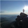
Once you get to treeline it is tundra and some talus hopping the rest of the way.
I'd consider this a good winter route as well because of year-round access.
I would've done a TR on my trip but kept saying to myself "man, it is shavano in the spring, not The Angel, a mundane ridge grunt, etc..."
Thanks very much for your help Papillon! It looks like a pretty straightforward route - just follow the CO Trail and once it makes that hard right, make your way up the drainage to treeline, then pick a friendly line toward the saddle and summit.
If you can post a photo or two depicting typical terrain in the trees, I would really appreciate it.
As someone said in an earlier post, it does look like the Colorado trail makes a nice "catch line" in case one gets off route.
Thanks very much again!