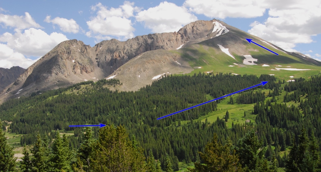
Taken from Fremont Pass, looking south,
1 and
2 show Mt. Arkansas and the approach to the north ridge. From your parking spot near the dirt road junctions, walk a few feet up a road (
3) that heads south from the main, dirt road and turn right (west) onto an old rail line which no longer has rails but the dark rock is still in place -
4. Follow the rail line for nearly 0.25 mile and turn left (south) into the forest, without a trail. If you followed the line to a stream crossing, backtrack a bit before heading into the trees because following the stream up the hill will lead you into thick willows. Once in the forest, continue south up through the trees. There are game trails that head south so you might get lucky and find one that makes the hike a breeze. You may pass through one or more clearings (
5) before hitting tree line near 11,600' (
6), 0.7 mile after leaving the rail line. On easy terrain, continue south/southwest to reach a broad saddle marked as 11,823' on the topo map -
7 and
8.
Your next goal is to hike 1,100' up a steep slope to reach the north ridge -
9. From the saddle, grind southeast up the slope (
10,
11 and
12) to reach the crest of the north ridge (
13), near 12,900'. Turn right (south) and hike along the ridge. Near 13,300', reach more rugged terrain where another ridge spurs off to the northeast. Stay right and continue south -
14 and
15. Ascend a couple of bumps and walk along an interesting flat section (
16) and you'll finally get your first view of the summit -
17.
But first you must pass the crux section of the climb - some towers (seen in
17) that require Class 3/4 climbing if you take them head-on. To bypass these difficulties, drop to the right (west) about 50-80' below the ridge crest and continue on Class 2 rock (
18) before regaining the ridge just beyond the towers-
19. Continue along the ridge crest (
20 and
21) to reach the summit -
22,
23 and
24.
