| Report Type | Full |
| Peak(s) |
Maroon Peak - 14,163 feet |
| Date Posted | 07/03/2010 |
| Modified | 07/08/2010 |
| Date Climbed | 06/22/2010 |
| Author | hansolo35 |
| Bangin` up the Bell Cord |
|---|
|
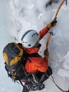
15 years ago I moved to southwest Colorado (Ouray) and began a quest to climb the 55 peaks that reach 14,000 feet or higher. Over the two months in the summer that I was there, I managed to climb seven of 14,000 foot peaks, all in the beautiful San Juan Range. Then a few years later, during summer break from college, I made a quick trip back to Colorado to climb its highest peak- Mt. Elbert, which meant that 8 of the 55 were in the bag. And then there was a long hiatus from the 14ers that has stretched 13 years since that last climb of Elbert. Well, I have been yearning to get back on the quest, and so began a trip to Aspen last Monday (6/21) with the intent to get high in the Colorado sky. The summit I was aiming for was Maroon Peak in the famous and spectacular Maroon Bells group. I have seen many different pictures of the Bells, and they are probably the most photographed of any Colorado peak. They deserve their popularity, as the Bells are practically sheer, with ledges of snow stepping up to their pointed tops that give a layer of rugged texture. Millions of people gaze out to the Bells as they are skiing the slopes of Aspen, although when I was skiing Aspen Highlands back in February, the Bells were hidden by snow clouds. There are two primary summits that comprise the Bells- Maroon Peak and North Maroon Peak, with both being some of the hardest of the Colorado 14ers to climb. So I went to bag Maroon, with possibly an ascent of North Maroon to follow depending on the situation. So on Monday I left Salt Lake and drove six hours to Aspen, which was a busy, bustling resort town, much more so than it was when I was here just a few months ago during the winter season. But I didn't stay in town long, only enough to stop off and buy some beer, and then I was headed up the lovely canyon past Aspen Highlands to the end of the road at Maroon Lake, where I saw the Bells for the first time in real life. They were certainly justified in their popularity. I quickly geared up and on the trail past Maroon Lake, where it led up a small headwall filled with aspen trees (which would be spectacular to see in the fall when they sprout gold), past the rocky triangle of Pyramid Peak on the left (another 14,000 foot summit, which I will be back later to climb), and finally to the shores of Crater Lake after an hour of swift hiking covering a few miles. The sun was starting to set behind the ridgelines by the time I found a campsite nestled in the trees above Crater Lake. If one were allowed by the Forest Service to camp along the shores of Crater Lake, then this campsite would've been very inspiring, surrounded such as it was by three different 14,000 foot peaks, all of which were wild and rugged. Instead, the established campsites were in the trees, which blocked most of the views, and were just OK. Once camp was established, I cooked dinner and relaxed before hiking down to the lake to watch the last of the sunlight fade off the summit of Pyramid. Then I retired to my tent early (8pm) to read a little before going to bed. I had an early start time tomorrow morning slated at 5am. I woke up several times throughout the night and looked up to see the stars, and although the night was clear and I was in the midst of a rugged wilderness at 10,000 feet, the stars surprisingly lacked their expected brilliance...they were not nearly as bright as they were when seen from the slickrock deserts of the Escalante. I finally drifted off to sleep. The next morning (6/22) I slept thru my desired wake time of 4:45am and instead got up at 5:30am, which was slightly disappointing. So I quickly dragged my groggy head and body out of my tent, made some hot chocolate, and then booked off on the climb of Maroon Peak. The daylight was already creeping down the face of the Bells as I made my way around the western shoreline of Crater Lake. Once past the lake, I jumped on the snowfield that drained the dramatic eastern cirque of the Bells, and made my way up a snake of snow that split a tall cliff band called "the Garbage Chute". I stopped to put my crampons on and made my way to the top of the chute. I was in the sunshine at this point, and it felt good. I then traversed on snow over to the base of the Bell Cord, which rose strait up for nearly 2,000 vertical feet at an average pitch of 42 degrees (with the steepest pitch reaching 45 degrees). I then began my assault of the Cord at 8:30am, and it was just one front-point after another. The ascent was pretty straight-forward, with the only real interesting aspects being comprised of playing dodge ball with the flying rock missiles that barraged me after de-thawing from the upper slopes of the Bells. I could watch them as they tumbled and rolled down the Bell Cord, some coming right at me, where I had to time my dodge just right so that I wouldn't get my head taken off. Otherwise, it was just a straight-forward climb up a wonderful and classic snow shot. After an hour and a half of steady climbing I reached the saddle that split Maroon Peak from North Maroon, and was instantly greeted by a cold blast of wind, which I had heard howling as I neared the saddle from the Cord. At the top, I took my crampons off, stashed them in my pack and then began a blind ridge scramble up to the summit. I had climbing beta for this part of the climb but was too lazy to pull it out and read, so I just looked for the best rock slabs to climb and made my way up. I was aided with the help of some rock cairns, although some of the class 3 moves were made trickier by frozen snow patches sprinkled throughout. The day was gorgeously sunny, but the cold wind howling from the northwest was making it slightly uncomfortable at times. The exposure to the west was considerable and a fall anywhere wouldn't be good, although most of the rock was good. Finally there was one last little obstacle to overcome and suddenly I was walking the last 20 steps to the very top of Maroon Peak. It was a relief to get there. I plopped myself down on the summit rocks, with outrageous views surrounding me at every turn. To be on top of the Bells is to be treated to a wonderful alpine spectrum- mountains everywhere. Immediately to the east stood the ragged hump of Pyramid Peak (14,018 ft.) anchoring one end of a long ridge. Behind it to the south-east stood the Elk Range's highest summit- Castle Peak (14,265 ft.). To the west stood two more 14ers- a still very-snowy Snowmass Mountain (14,092 ft.) and Capitol Peak (14,130 ft.). Off to the east, far away, stood other high peaks of the Sawatch Range that I could tell contained still more 14ers. And finally, to the immediate north stood North Maroon Peak (14,014 ft.), which was tentatively slated to be climbed on this outing too. I was examining the ridge that divided me from it and to be honest, it frightened me a bit. The exposure on both sides was awesome, and a fall along it would be mandatory death, regardless of which side you fell on. The Bells definitely guard their heights well. Plus, despite the great weather (despite the wind), there was not a single other soul up there, and I didn't want to make the ridge crossing alone. I did relish having the top all to myself however. In addition, I was feeling pretty poopered, and realizing that getting to the top is optional but getting down is mandatory, I decided that North Maroon will just have to wait for another outing. So I enjoyed myself on top, relaxing up there at 14,000 feet for over an hour. I was just in awe of the jaw-dropping sights all around me. Then it finally came time to bid farewell and begin the descent. I started to make my way down the south ridge when a thought occurred to me that rather than work my way down ledges in a slow and tedious manner, I would go check out the southeast couloir to see how it would go. After doing some fun down-climbing, I reached the top of the couloir. It looked steeper than the Bell Cord in fact, although not as classic, and I decided that I would risk it and try to descend its snowy drop. So I put my crampons back on and began to downclimb the steep snow. It was a lot of work and a little scary, but I made my way down enough to where after a half hour or so the angle of the snow lessened just enough to where I felt comfortable enough to slide down the snow in one of the runnels. Using the runnel like a natural waterslide, I slid down on my keester, keeping my speed in check with gouges from my ice axe. Doing this allowed me to lose a lot of elevation quickly (and in a fun way) although at the expense of a wet and numb ass, and before I knew it I was at the top of the Garbage Chute. I then went into a very relaxed mode as I made my way down the chute, with shadows of afternoon replacing the shadows of early morning. I saw an elk crossing the scree, as well as a goat above me, before I left the last of the snow and re-joined the trail. Then it was a quick hike back to camp, which I reached at 4pm, where I had a cold Sierra Nevada stashed in the creek. I enjoyed it in celebration of my successful ascent before taking a nap. I was passed out in my tent when I was awakened by a sound that I thought was a baby murmuring. In reality, it was a pair of white porcupines that were raiding my camp. I had all of my food and smelly items stashed in a tree, so for the life of me I couldn't figure out what they were after. I tried to scare them off a few different times, only to see them retreat out of the light. After the third time of waking me up, I looked out my tent to see one of them knawing on the rubber grip of my ski pole, which was then that drastic measures needed to be implemented. I quickly jumped out of my tent, grabbed some fist-sized rocks and lobbed them at the animals, hoping that would do the trick. And it did- they didn't come back for the rest of the night. To display your photos (uploaded below) in the final trip report, type the image number (i.e., 1, 2, 3), highlight it with your cursor, and click on the Image button on the right. Example: 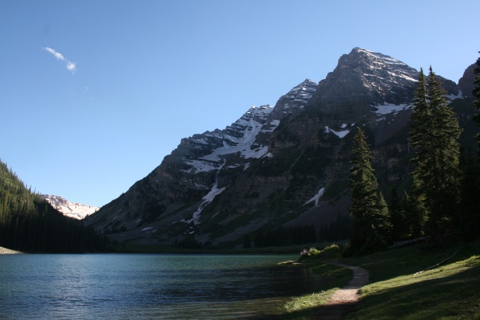 Thumbnails for uploaded photos (click to open slideshow):
 looking up the Bell Cord")
 at the to of the Cord")
 looking to North Maroon, from Maroon Peak")
 looking to Snowmass and Capitol Peaks")
 view east to Pyramid Peak")
 looking 5,000 feet down to Crater and Maroon Lakes")
 Crater Lake framed by Garbage Chute")
 the Bell Cord doesn't look so steep from this angle")
 me and the Bells")
|
| Comments or Questions | ||||||||||||
|---|---|---|---|---|---|---|---|---|---|---|---|---|
|
Caution: The information contained in this report may not be accurate and should not be the only resource used in preparation for your climb. Failure to have the necessary experience, physical conditioning, supplies or equipment can result in injury or death. 14ers.com and the author(s) of this report provide no warranties, either express or implied, that the information provided is accurate or reliable. By using the information provided, you agree to indemnify and hold harmless 14ers.com and the report author(s) with respect to any claims and demands against them, including any attorney fees and expenses. Please read the 14ers.com Safety and Disclaimer pages for more information.
Please respect private property: 14ers.com supports the rights of private landowners to determine how and by whom their land will be used. In Colorado, it is your responsibility to determine if land is private and to obtain the appropriate permission before entering the property.