| Report Type | Full |
| Peak(s) |
Snowmass Mountain - 14,105 feet |
| Date Posted | 05/06/2010 |
| Date Climbed | 07/05/2009 |
| Author | clemsonmtneer |
| July 09 - Snowmass Mtn |
|---|
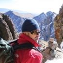
Snowmass Mountain (14,092 ft.)Climbers: Alan (clemsonmtneer), Matt (MontanaMatt); later met up with Brian on the mountain Date: 7/4 to 7/5, 2009 Route: East Slopes (base camp at Snowmass Lake) Starting Point: Snowmass Creek Trailhead (8,400 ft.) Elevation Gain: 5,692 ft. RT Mileage: 21.5 miles This is another outdated trip report, but hopefully it will provide some useful beta for anyone planning to attempt this route this summer. The trip came about a week earlier while climbing Wetterhorn Peak in the San Juans, when I met Matt on the way down. Our groups had stopped to chat about the climb when he mentioned that he was looking to finish the remaining 14ers on his list over the next few weeks (he was moving to Oregon soon) and was looking for partners. I said I would be interested, so we got in touch after that weekend and he asked if I would join him for Snowmass on the 4th of July weekend... I could either stay in Denver and go to a couple of 4th of July parties (like my non-outdoorsy friends wanted me to do), or spend the weekend camping and climbing mountains... the decision was easy. Matt and I met at the Dinosaur lot off I-70 near Golden on Saturday morning the 4th, and arrived at the Snowmass Creek Trailhead around noon, ready for the 8-mile approach to Snowmass Lake. At the time, we were in a big-time monsoonal flow pattern with lots of rain and storms all spring and summer so far, and as it turned out this weekend was no exception. There were already a lot scattered clouds building early in the day, and within the first half mile of our hike it started dumping rain on us, lightning, and hailing. Fortunately we had pack covers and rain gear, but we were still soaking wet just like that. After a little while it cleared up, then it rained on us again later, and that's pretty much how the day went, though the weather cooperated a lot more after the first three miles. The hike up the valley was beautiful, just a very nice and lush area. Looking back down the valley, shortly after the storm cleared up  Matt hiking on the Snowmass Creek Trail  Fortunately, even though the approach to Snowmass Lake is long, the elevation gain is very gradual. After six miles, however you do come to a pretty big obstacle... the log-jam crossing of Snowmass Creek. During early summer, the river levels are at their highest, so the best way to tackle this (well, maybe not the best, but it's one way to do it) is to carefully walk across the logs using trekking poles for balance (for anyone planning on crossing the log-jam, trekking poles or ski poles are a MUST). We were able to make it across without incident after 10-15 minutes, but we had to be very carefully to watch out for loose logs because there were a lot of them. Matt crossing the logjam   The last couple of miles to camp were very scenic, though we were moving slower by this point since the miles were adding up and we were carrying heavy packs. Nearing camp  Snowmass Creek  Just before 5:00 we reached our campsite at Snowmass Lake, and the scenery was absolutely stunning, with the turquoise lake surrounded by rugged and snowy peaks. The lake would be (and is) a worthy destination in of itself even if you don't plan on climbing the peak. We were able to have a relaxing evening and met a couple of other people camping at the lake who were planning to climb Snowmass the next morning as well. There were some clouds hanging over the surrounding peaks (made for a dramatic view when we first arrived), but the weather seemed to be holding out. Our first dramatic view once reaching camp - Snowmass Peak (not Snowmass Mountain) rises above  Snowmass Lake  Snowmass Mountain (high point in the center)  We planned to get a super early start the next morning because of the way the weather forecast was looking. The air was very unstable and thunderstorms had been starting earlier in the day than normal, so we set our alarm for 2:30 a.m. There was one other guy, Chris, who planned to join us for the climb and meet us at our tent just after 2:30, and another guy, Brian, was planning to climb as well and said he would look for us on the mountain. After turning in just after nightfall, things got interesting and not much sleep was had. Shortly after we got in the tent, we heard rain drops start to pound on the tent, then later on it blew up into a thunderstorm. Well, the cycle kept repeating itself. Every 30 minutes or so, a new storm would blow through with lightning, loud claps of thunder, and heavy rain. It made sleep nearly hard to come by, and had us seriously worried about our climb the next morning. Our worries were confirmed when our alarm went off at 2:30 during the middle of yet another raging storm. We now had a dilemma on our hands. Chris came up to our tent in the pouring down rain and asked us what our plans were, and we all decided just to wait it out and get moving once the rain stopped. Around 3 the storm let up, so we started to get moving. Due to a lack of communication when Chris had come up to our tent during the storm, we never really planned on where to meet or if we were supposed to find him when we were leaving. I'm not sure what he ended up doing, but we never saw him again so I guess he decided to bag the climb altogether. Once we started hiking, around 3:30 or 3:45, the sky above us was completely clear and the stars were out, so we hoped that the storms were over for the night. We hiked along a primitive trail on the west side of the lake that pretty much circles about halfway around the lake before you hit the boulderfield where you start heading up. The path goes straight through a bunch of willows, which of course were soaking wet, making us soaking wet in turn (luckily we had rain gear and pack covers on). When we got to the far side of the lake where the route heads up, we saw a headlamp behind us, and decided to wait thinking it might be Chris. After 10 or 15 minutes the guy in the headlamp caught up to us... turns out it was Brian, the other guy we met at camp, so we all decided to team up for the day. We started heading up, following cairns through the boulderfield. It wasn't long after that we noticed the stars above us starting to disappear. Seems that some clouds were moving in. Then we saw a couple of flashes just over Snowmass's ridge. Not good. We discussed our options for a few minutes, none of us liking the looks of things, while also agreeing that we didn't want to risk being caught in a lightning storm higher up. So we retreated for the time being back down to the lake, where we would wait and see what happened with the weather. We sat for a while and it slowly started to get light outside. We were very close to calling it a day and heading back to camp, when all of a sudden the clouds over the ridge started to break up as the sun was coming up. Suddenly we had a window of opportunity so we switched gears back into climbing mode and began to head up the boulderfield. Early morning scenery    I figured out pretty quickly once we started ascending that it was not my day. I felt like crap. I'm sure the lack of sleep had something to do with it, but overall I was just having an off day and moving more sluggishly than normal. Matt and Brian moved up the mountain quicker than I did as a result, but would always wait for me at rest stops (for the first time since climbing 14ers, I knew what it felt like to be the slow one of the group!). The boulderfield ended up being the worst part of the entire day. The bottom part of it closer to the lake wasn't bad, but the higher we got, the steeper and looser it got. A couple of parts were really sketchy to say the least. I accidentally knocked off a decent sized rock slide at one point, and that definitely got my attention. I yelled "ROCK" as loud as I could, but thank god nobody was below me, because that could have been ugly. Eventually we reached the top of that hideous boulderfield, and that was a major relief. It was time for us to put the crampons on and get the ice axes out because a long snow climb awaited us. Looking at what lay ahead of us   The climb up the snow was a refreshing change of pace. The snow was firm, making it good for crampon use, and the slope angle was never that steep. However, the snowfield was long and gradually steepened the farther up we went, so it was still a good workout that had my calves burning much of the way. As we made our way up, incredible early morning views of the Maroon Bells and other Elk Range peaks opened up behind us. Maroon Bells and Pyramid Peak    Matt and Brian working their way up the snowfield  For reference, the summit is the middle point, we were aiming to hit the ridge on the left point  More awesome views behind us   Working our way up   It seemed like that snowfield would never end, but eventually we hit the ridge, with one Class-3 rock scrambling section left until reaching the summit. The saddle between Hagerman Peak (left) and Snowmass Mountain  Looking back towards the Bells and Pyramid  Elk Range views looking west   Looking at the final ridge scramble to the summit  Matt and Brian continued on towards the summit while I rested, took my crampons off, and forced myself to eat. Low clouds were starting to roll in over the summit ridge, but they weren't building into thunderheads (yet), so I felt like getting the summit was still safe, especially since we were so close. We stayed below the ridgeline on the left side before gaining the ridge again a little below the summit, the following it the rest of the way up. The climbing here wasn't bad at all. It was actually quite enjoyable. The route-finding was mostly straight-forward and the rock was solid by Elk Range standards. Fog rolling in with the summit just ahead  Looking back towards the saddle  The fog was starting to get pretty dense on the ridge, but I kept going up and all of a sudden I saw a single pointed rock that was the highest point... I had reached the summit. Getting the summit on a day when the weather had given us little window of opportunity, and when I also wasn't feeling it, was a big relief and that much more rewarding. It also felt very remote on the summit, which isn't something you often feel on a 14er, especially in July. We would end up being the only ones to summit Snowmass that day. Even though it was only 9:20, we didn't hang around long since we were a little concerned about the weather, but of course I had to snap a few pictures. Snowmass summit  I was about as tired as I look in this picture!  Sweet-looking ridge on the other side of Snowmass  Looking back to where we started at Snowmass Lake  Geneva Lake  After we got back to the saddle, it was time for the fun part... glissading! This was by far the biggest glissade I've ever done. I had only practiced glissading before on short, mellow snowfields so this would be different. Fortunately, the snowfield is huge with a long and safe runout. Looking down at Snowmass Lake right before the glissade  Brian glissaded first because he needed to get back to camp quickly since his girlfriend was waiting for him. Matt went next, then it was my turn, and what a sweet glissade it was! It was really long and fast enough to be a lot of fun. And we must have slid a good 1,500 vertical feet or so on our asses, cutting off a huge amount of time on the descent! So yes, when you don't have skis, and there's lots of space with a safe runout, glissading is the way to go. If you've never done it before, this is a great place to try it out and to practice using your ice ax to control your speed. Looking back up at our glissade "tracks"  I was dreading going back down the loose boulderfield, so instead I cut left across a stream that borders the boulderfield, which has a climber's path through grass on the other side. It was steep and had lots of loose dirt, and I ate it at least 5 or 6 times, but I still thought it was better than all of the loose crap on the other side. The lesser of two evils if you will. As frustrating as going down this part was, the parting views kept my spirits high. The Bells again  Snowmass Lake with its awesome turquoise color  Surrounding peaks (yep, it's looking stormy again)  We got back to camp just after 11, and as much as I had hoped we could chill out and maybe take a quick nap before packing out, stormy weather was starting to roll in so unfortunately that wasn't going to happen. It started thundering and raining lightly so we decided to quickly pack up camp while everything was still dry. The wind had picked up big time and it was actually getting pretty cold by the time we were leaving. Parting shots of Snowmass Lake, Snowmass Peak, and Snowmass Mountain under stormy skies right before we left   The hike out wasn't without some excitement. We had to cross that damn log jam again, and for some reason (probably a combination of windy conditions and being exhausted) it was a lot harder this time around. It wasn't easy, but I made it across without incident until the final log I stepped on before reaching shore gave way, and I sank down to my knee. So the last six miles would have to be hiked with a wet right foot. The rest of the hike out was fine, just slow since we were tiring quickly. The weather cleared up farther down the valley, though, and it warmed up considerably. After it seemed like the trail would never end, we finally reached the car. It had been one hell of a weekend, but in spite of mother nature's best attempt to keep us away, we were able to luck out and make a push for the summit in the only window of opportunity we had. Also, the scenery in that area is unbelievable, some of the best I've ever experienced (which is saying a lot!). Hungry and tired, we stopped in Carbondale on the way back and had a champions meal of chicken pesto pasta, apple pie, and beer, at which point everything seemed right in the world. |
| Comments or Questions | |||||||||
|---|---|---|---|---|---|---|---|---|---|
|
Caution: The information contained in this report may not be accurate and should not be the only resource used in preparation for your climb. Failure to have the necessary experience, physical conditioning, supplies or equipment can result in injury or death. 14ers.com and the author(s) of this report provide no warranties, either express or implied, that the information provided is accurate or reliable. By using the information provided, you agree to indemnify and hold harmless 14ers.com and the report author(s) with respect to any claims and demands against them, including any attorney fees and expenses. Please read the 14ers.com Safety and Disclaimer pages for more information.
Please respect private property: 14ers.com supports the rights of private landowners to determine how and by whom their land will be used. In Colorado, it is your responsibility to determine if land is private and to obtain the appropriate permission before entering the property.