Columbia Pt. (13,980'), Challenger Pt. (14,081'), Kit Carson Peak (14,165')
August 29, 2009
From South Colony Lakes 4WD parking.
Round Trip: ~10 miles
Elevation Gain: ~4,800'
Scrambling Lead and Partner in Route Finding: Donna
The more I thought about it, the better it seemed. Every single time I read or heard about someone complaining about the "standard" route for Kit Carson Peak and Challenger Point, there was always an emphasis on how unpleasant the descent from Challenger is. Combine that with the five mile backpack into Willow Lake, and my increasing confidence in taking on more challenging, less frequently traveled routes, and a decision suddenly became very easy. Kit Carson's East Ridge from South Colony Lakes would be the order of the day. Especially since I had an appointment with a couple of other interesting mountains on that side of the range...
Donna and I departed from south of Denver just before 5 p.m. on Friday afternoon, and made surprisingly easy time all the way into Westcliffe. Colorado Springs rush hour traffic had me concerned, but as it turned out, there was nothing to be concerned about. The pavement of Colfax Lane transitioned to smooth dirt, then to washboard, then back to dirt as it climbed into the trees at the mouth of the amazingly long South Colony valley. Passing through the soon to be end of the road, and new parking area, it was obvious that this might be a busy weekend, as vehicles of all flavors were parked in nearly every obvious spot along the legendarily rough and annoying road, all the way to the upper four wheel drive parking, where the only open spot beckoned to me. Ironically, it was also about as level a spot as there is at this trailhead, and would serve us well for two nights of car camping.
The 4 a.m. alarm broke toasty slumber, and with the usual reluctance to give up the safety of the sleeping bag, I forced myself into preparation. Dark and cool, it was surprisingly comfortable for the last few hours of August at high altitude, and 100-weight fleece proved to be too hot within the first hour of the hike, as we used the pack trail from the parking area directly to the bench east and above the lower lake. This is an incredibly efficient trail, and I feel bad for anyone that hasn't taken the time to research it and use it for approaching Humboldt or just the upper lake. As our headlamps melted into the dawning day, I made the decision to forego the Humboldt ridge and instead traverse above the upper South Colony Lake, aiming for the back of the bowl, where a scree gully was recommended to provide better passage to the Bear's Playground, our first destination of the day. In hindsight, I'm not very enthusiastic as I remember the loose scree and talus along the slope, all the way into the bowl. Fortunately, a herd of Bighorns came crashing down from the ridge, directly above our intended route, and it was very enjoyable to just stop and watch them negotiate steep ledges like they were on level ground. They are amazing animals.
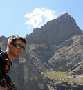
New desktop background...

Heading for the "easiest" looking gully, center...

A section of larger talus provided a reprieve from the predominantly loose traverse, and we were quickly making our way up the even looser gully. Making an effort to stay left on more solid ground and rock, we picked our way up, and it was anything but easy going. The South Colony area is infested with giant thistle plants, and they were plentiful along our path, as we each found out in one way or another. They certainly don't make for good holds!
Donna searches for anything that might stay attached to the mountain...

The locals were surely amused by us...

It looks like it's getting better...

Finding marginally better terrain higher in the gully, we were both surprised to pop out suddenly at a large cairn with the Bear's Playground stretching out before us, 13,799' "Obstruction Peak" living up to its name, as it guarded our first true target of the day, Columbia Pt. We descended towards the Humboldt ridge, as I knew a series of cairns should make themselves apparent at some point, and guide us across the broad south slope of the bi-centennial thirteener. There were several people on the summit, which surprised me.
The obstructed Columbia Point...

Humboldt Peak from the top of the gully...

True to the beta, we found the first cairn, and simply looked for the next, in a perfect line right across the slope, aiming for the Columbia-Obstruction saddle. It was pleasant, easy hiking across talus and trail, and we made good time across to the ribs and arêtes that crop up at the west end of the mountain. The cairns remained true, and there was little difficulty in finding the route to the saddle, where we could begin the day's business of climbing mountains.
Look over your shoulder, there's likely something spectacular to see here...

The trail of cairns leads exactly in the right direction...

A little bit more rugged terrain along the west end of the traverse...

Columbia Point directly in our sights...

A good look at the route, as it works to the left along the obvious ridge...

Four hours into the hike, we were finally at the base of the first peak of the day. The sun was warm, the wind benign and the temperature perfect for this endeavor, and we only paused briefly along the saddle to peer down into the upper Willow Lake basin, and get a taste of the huge exposure that runs along the northern edge of the entire Kit Carson Mountain massif. The cairned trail continues along the ridge and onto the slopes of Columbia Point, as it switches back, weaves and dodges its way up. It's easy class two climbing all the way to the edge of the summit of "Kitty Kat" Carson with an easy class 3 move thrown in right at the crest of the ridge. From the eastern sub-summit of the peak, it's a hop, skip and a jump over to the true summit. Well, maybe a little further.
A trail weaves through the difficulties..

The conglomerate rock makes for a very confusing landscape, but cairns save the day...

The busy summit of Columbia Point from "Kitty Kat"...

Two climbers greeted me on the summit, as they relaxed and enjoyed the perfect day. The views of the Sangre de Cristo range were already breathtaking, even from this relatively obscured peak. The Crestones dominate the area, but the Blanca group thirty miles to the south also scream for attention, with the wafting dunes of sand at their base making for a picture postcard to send to those sea level dwelling relatives. Of course, Kit Carson Peak is massive as it blocks the view of anything but sky to the west. We took a few minutes to enjoy a break and have a snack, and contemplate the complexity of the next few hundred feet of climbing. I had printouts of two trip reports by 14ers.com user "flyingmagpie" that seemed to detail the route quite well, and was confident that we would not have any issues. A group of five had already begun their descent, so we could also watch their progress.
The Blanca Group...

Massive Kit Carson Peak...

The memorial plaque, still intact even though vandals have damaged it this summer...

The initial down climb from the summit of Columbia Point follows the ridge to the south, towards a very prominent fin or prow, then turns right at a cairn and crests over onto the west face, where the route finding challenge begins. We followed a ledge down to where it looked like an obvious series of benches would connect us to another ledge below. There didn't seem to be any other options. I was already convinced that we were off route, but the terrain is confusing and complex, and we did see a cairn ahead, so we just worked our way down the easy class 3 gully. Arriving at the next pronounced ledge, the route still did not look obvious, though, and it was decision time. I was looking for anything similar to the pictures I had with me, but did not see the class 3 down climb that was supposed to be in front of us. Instead, a long gully led us straight down the face, about 200 feet of solid class 3 down climbing, with a bit of an interesting class 4 move at the very bottom, where a cairn pointed us towards Kit Carson. Though not overly difficult, it is steep, and a slip could produce very negative results. As we exited the gully over a small rib, another obstacle mocked us, a class 4 side step over a smooth slab, with nothing but air to land on. This was by far my most nervous moment of the day. I hugged the overhanging rock and found myself spread eagled, trying to shift my weight from one foot to the next, while the rock pushed against my chest, attempting to use my back pack as an aid in throwing me away from the mountain. Awkwardly I managed to land back on my feet, safely away from the void, but my heart would take a while to catch up.
I guess we'll just follow this down...

Almost to the bottom?

Our next destination...

We found ourselves well below the notch at the top of the Cole Couloir, but only a short jaunt from the start of the Avenue, our ascent route up and across the sheer south face of Kit Carson Peak. Our off-route adventure had actually worked out quite well. As we began up the Avenue, we ran into a few climbers, most of whom assumed that we were on our way back to Challenger, not attempting it for the first time. I'm surprised that more people are not aware that this route has been used for a very long time, and it's not really a secret. One group caught my eye, and I was certain that I recognized them. I've hiked with Jen and Amy, and Lee was on Culebra with me last summer. It's always fun to run into people on the trail, but more so when you know them, but didn't know they were in the neighborhood. We chatted a bit, shared some beta, and parted ways, Donna and I continuing our uphill grind to the top of the Avenue. I failed to notice the exposure that so many speak of, it's really just a trail along the side of the mountain. Dropping down to the saddle with Challenger was a welcome relief, and we barely paused before heading straight up Challenger Point. Route finding was surprisingly more difficult than I expected, and we rock hopped and connected trail segments all the way to the summit, where four University of Oklahoma students were basking in the day's glory. I took their group photo, and had a little fun as well, as I yelled out "Go Buffs!" just before snapping the pic. 
Finding a trail to the summit of Challenger Point...

Looking back from where we came, and have yet to go...

A better look at the Sand Dunes...

After a little bit longer of a break, we set off for yet another summit, the weather beginning to change a bit, as dark clouds formed to the north and east. I had a feeling that we were in good shape, though, based on my observations of the weather all summer, and was not overly concerned. At this point, there's no help for it, as we are a long way away from our camp anyway. The only option is to keep moving. The descent back to the Avenue was easy and quick, and the cruel uphill slant back to the Prow was not overly taxing. We dropped down the other side and quickly descended, giving up precious foot after precious foot that would need to be re-climbed in only a few minutes. A brief visit with Lee and Jen served as an adequate break, before I pointed out the 3rd class gully that makes a great short cut to avoid the entire scree gully that the standard route follows. Donna was a kid in a toy store when I turned her loose on that stuff.
The Avenue from the Challenger-Kit Carson saddle...

Columbia Point dead ahead; Lee and Jen can be spotted low on the avenue...

Donna flies up the 3rd class gully...

Beautiful conglomerate climbing...

Back on the standard route...

Easy scrambling to the summit of Kit Carson Peak!

Our third summit of the day had me a bit tired, but feeling very charged at the same time, as the realization of what we'd done began to sink in. Even though the views didn't change much from Columbia to Challenger, the main peak's loftiness allowed for better angles in every direction, with a stunning view of the Crestone Group to the south east. The northern Sangres make a beautiful, pointy skyline, and the Blanca Group was resplendent on this day, with Lindsey's mass on the left, and the squared off block of Little Bear providing perfect bookends. Looking down at the west face of Columbia Point, I was still wondering how we were going to climb back up that thing. It appears as a sheer wall of rock from this distance.
Pow! Columbia, Obstruction, Humboldt, Marble, Needle, Peak, Pico Aislado...

Next year... *sigh*

Tomorrow... *sigh* 

We spent about 15 minutes on the summit, watching the weather, snacking, drinking, and psyching up for the impending difficulties of the rest of the day. We still had a lot of work to do, and the ascent back up Columbia was sure to be a challenge. As we made our way down, a stroke of good fortune met us, as I stopped to chat with a couple on their way up. They had just come over Columbia, and found the correct route. Pointing me in the right direction, I could clearly see the cairns that we would want to follow, at least back to the top of the Cole. Then it would be a matter of spotting the cairn that marks the entrance to the correct gully to ascend. It seemed simple enough. And turned out to be, after a somewhat difficult move to gain a ledge, a traverse over to a cairn led to a steep, knobby down climb into easy class three scrambling straight up the gully. Although flyingmagpie's trip report states that it's "20-30 feet of class 3", it's actually about a hundred or more, but it is solid, and not difficult. At the time, I was not convinced that we were on route, but now that I look back at my pictures, it sure seems that we were. Exiting onto a ledge at the top, the summit was directly over head, but neither Donna nor I could see where the route was supposed to go next. It felt like we were too high on the mountain, and I'm still not sure where we came down. Oh well, up seemed good, so Donna began scrambling again, straight up third class rock towards the ridge crest. I followed. A five foot tall class four cliff separated the top of the crack that we followed from the exit ledge to freedom, and I struggled to make the move. With much deliberation, I finally figured out how to get my feet far enough apart to lift myself up and onto the exposed ledge, and powered over it. The adrenaline was culpable, and I had to stop and gasp to slow down an exploding heart rate. I suppose exhilarating would also describe the experience. Maybe I'm learning to like exposure?
Looking down the Outward Bound Couloir; I don't think it's "in"...

Third class scrambling straight up to the fault above the OB Couloir's left arm...

A look back down the route...

Donna in the center, preparing to negotiate the class 4 move to the top...

Another gratuitous photo from the south face of Columbia Point...

Relief set in, as we crested the ridge next to a cairn, and could see smooth sailing ahead. At least there would be no more exposed climbing. The rest of the hike was surely to be grueling, as we still had to drop down the steep east face of Columbia, and then the long traverse back to the Bear's Playground. A decision would need to be made there, to venture onto the Humboldt ridge, or chance the nasty scree gully of our morning warm up. Neither option appealed to me very much, but it was too early to worry about such things. Dropping onto the saddle with Obstruction Peak, it was just a matter of finding the right cairns to lead us back to where we desired. By now I had given up on the idea of climbing Obstruction Peak, even though it really looked too close to pass up. Thoughts of climbing Humboldt yet this day also became fantasy, as my lungs, back, feet and knees teamed up to beat my brain into sensible submission. Let's go find some food! And maybe a cold beverage...
Peering down at the upper Willow Creek Lake from the saddle...

A fleeting glance at Columbia Point, thanks for letting us pass!

Traversing back onto the Bear's Playground, I was still deliberating on the best route. I told Donna that I was tired, and that the ridge looked like it could be a bit interesting, and she agreed that following our ascent route back down the scree gully would be as good as any. I wish she had convinced me differently. It wasn't all that difficult, but the sustained resistance to falling that is required to descend this terrain is exhausting, and my legs and back were screaming for mercy. Instead of traversing back along the slope above the lake, I led us straight down into the drainage, a decision that I'm quite happy with. Once we were off of the steep apron of the gully, the hiking became easier across grass and larger talus, with only a short stretch of loose, blocky talus hopping producing trivial challenge. Picking up the trail at the west end of the upper lake, I eye balled the direct start to the Ellingwood Arete, and thought, "Ehh, that's not so bad!" Don't expect me to be climbing it in this lifetime! Once on the trail, the rest was elementary, and we arrived back at camp shortly before 6:30. A thirteen and a half hour day, approximately 10 miles, and around 4,800' of elevation gain. Seemed like more to me. My brother greeted us with fresh, warm fried chicken, and I had to choose between Deschutes Black Butte Porter and Grand Lakes Wooly Bugger Nut Brown Ale. Easy, I'll have one of each! The parking lot would get busier, as Kristin and Anne made their way over to say hi, and Derek and Zack pulled in shortly before dusk. 14ers.com was well represented on this weekend! We chatted until dark, and then set the alarm for Sunday's quest. Oh goodie, 2 a.m.
Nature rewards us for our efforts, simply beautiful animals...

|