Download Agreement, Release, and Acknowledgement of Risk:
You (the person requesting this file download) fully understand mountain climbing ("Activity") involves risks and dangers of serious bodily injury, including permanent disability, paralysis, and death ("Risks") and you fully accept and assume all such risks and all responsibility for losses, costs, and damages you incur as a result of your participation in this Activity.
You acknowledge that information in the file you have chosen to download may not be accurate and may contain errors. You agree to assume all risks when using this information and agree to release and discharge 14ers.com, 14ers Inc. and the author(s) of such information (collectively, the "Released Parties").
You hereby discharge the Released Parties from all damages, actions, claims and liabilities of any nature, specifically including, but not limited to, damages, actions, claims and liabilities arising from or related to the negligence of the Released Parties. You further agree to indemnify, hold harmless and defend 14ers.com, 14ers Inc. and each of the other Released Parties from and against any loss, damage, liability and expense, including costs and attorney fees, incurred by 14ers.com, 14ers Inc. or any of the other Released Parties as a result of you using information provided on the 14ers.com or 14ers Inc. websites.
You have read this agreement, fully understand its terms and intend it to be a complete and unconditional release of all liability to the greatest extent allowed by law and agree that if any portion of this agreement is held to be invalid the balance, notwithstanding, shall continue in full force and effect.
By clicking "OK" you agree to these terms. If you DO NOT agree, click "Cancel"...
San Juans 14ers Bonanza 2009 - Day 1 - Handies Peak
We climbed Handies Peak via Grouse Gulch, over the pass, and down to meet the standard route in American Basin. In Roach's book, it says it's 8 miles with 4,100' of elevation gain, but we are very sure that is incorrect. Don't go into this climb expecting something too easy. It's a long slog out with 800' of gain on the return over the pass. Now, to the report. Finding the trailhead was a wild goose chase. In any books by Roach published before 2000, it says to take Colorado 110 past Howardsville and Eureka to the trail on the side of the road. When this book was printed, that road WAS 110. It is now County Road 2. The road leading from Silverton to Silverton ski area is now called 110. Naturally, we took the wrong road, but that's a different story.
The trailhead
After finally making to the trailhead, we made a very late start and began ascending the old mine road up the flank of the mountain.
After about 5 switchbacks, the old road continues toward Grouse Creek and grouse gulch and turns left to ascend it.
Grouse Creek
Looking down Grouse Gulch
The trail then continues for about a mile up the gulch, gradually ascending:
After about a mile, it starts to climb the left-side ridge of the gulch via switchbacks to reach the pass at 13,000:
This is when Handies comes into view ahead of you:
Now, you must descend the 800' to meet the main trail in American Basin.
The view of the trail you just descended
It was disheartening to have climbed for 3 miles only to descend a chunk of the elevation you worked so hard to gain. This is where we met the American Basin Trail and took it from near the bottom of the trail to the summit.
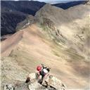
Our summit photo, me on the right, my Dad on the left.
There we met some nice people, took the summit photos, and began the descent. On the descent we met a friendly weasel sort of thing, and I got a couple photos of it.
Overall, it was a long tiring, but fun day. I realized I need new hiking shoes.
Thumbnails for uploaded photos (click to open slideshow):
Hi osub4u,
I'm the writer of this trip report but I changed the username. I'm glad to be able to help with your trip. I estimate that the hike took approximately seven hours for two fairly quick hikers to make it. The main concern was making it back over the pass before any bad weather moved in. Enjoy!
Thanks for the feedback the route looks long and kinda annoying, I saw the elevation gain near the end, (over the pass). That looks like it could be tiring at the end of a long day. I agree the San Juan's later in the day could be dangerous
Caution: The information contained in this report may not be accurate and should not be the only resource used in preparation for your climb. Failure to have the necessary experience, physical conditioning, supplies or equipment can result in injury or death. 14ers.com and the author(s) of this report provide no warranties, either express or implied, that the information provided is accurate or reliable. By using the information provided, you agree to indemnify and hold harmless 14ers.com and the report author(s) with respect to any claims and demands against them, including any attorney fees and expenses. Please read the 14ers.com Safety and Disclaimer pages for more information.
Please respect private property: 14ers.com supports the rights of private landowners to determine how and by whom their land will be used. In Colorado, it is your responsibility to determine if land is private and to obtain the appropriate permission before entering the property.


")
")
")
")
")
")
")
")
")
")
")
")
")
")
")
")
")
")
")
")
")
")
")
")
")
")
")