Download Agreement, Release, and Acknowledgement of Risk:
You (the person requesting this file download) fully understand mountain climbing ("Activity") involves risks and dangers of serious bodily injury, including permanent disability, paralysis, and death ("Risks") and you fully accept and assume all such risks and all responsibility for losses, costs, and damages you incur as a result of your participation in this Activity.
You acknowledge that information in the file you have chosen to download may not be accurate and may contain errors. You agree to assume all risks when using this information and agree to release and discharge 14ers.com, 14ers Inc. and the author(s) of such information (collectively, the "Released Parties").
You hereby discharge the Released Parties from all damages, actions, claims and liabilities of any nature, specifically including, but not limited to, damages, actions, claims and liabilities arising from or related to the negligence of the Released Parties. You further agree to indemnify, hold harmless and defend 14ers.com, 14ers Inc. and each of the other Released Parties from and against any loss, damage, liability and expense, including costs and attorney fees, incurred by 14ers.com, 14ers Inc. or any of the other Released Parties as a result of you using information provided on the 14ers.com or 14ers Inc. websites.
You have read this agreement, fully understand its terms and intend it to be a complete and unconditional release of all liability to the greatest extent allowed by law and agree that if any portion of this agreement is held to be invalid the balance, notwithstanding, shall continue in full force and effect.
By clicking "OK" you agree to these terms. If you DO NOT agree, click "Cancel"...
Debbie and I headed south of the equator to climb some big volcanoes and get a taste of South America. We started planning the details of this trip a week or so before we left, mostly just figuring things out after we got down there, it is easy to do this. The bus system in Ecuador is outstanding; reliable, cheap, safe (with our limited experience) and fairly comfortable. The street food is very good, order the almeurzo (set lunch) and hit up the markets. Don't shy away from local fare! Do avoid the saviche
Itinerary
June 20th - Arrive in Quito (~9000')
June 21st - Bus to El Chaupi (~11,000')
June 22nd - Approach to Refugio Nuevos Horizontes (~15,600')
June 23rd - Summit Illiniza Norte (16,818')
June 24th - Summit Illiniza Sur (17,267')
June 25th - Approach to Refugio Jose F. Rivas (~15,800')
June 26th - Summit Cotopaxi (19,347')
June 27th - Rest Day in Rio Bamba (~8,500')
June 28th - Approach to Chimborazo Refugio (16,400')
June 29th - Summit Attempt Chimborazo (18,900' highpoint)
June 30th - Summit Attempt Chimborazo (17,100' highpoint)
July 1st - Baños - hot springs and beer
July 2nd - Baños - see above
July 3rd - Quito - sights and Rucu Pichincha summit (15,413')
July 4th - Otavalo - markets
July 5th - Arrive in Denver - work
Gear (insurance picture )
Cost ~$2500 for both of us (we splurged a few times)
After arriving in Quito and staying at the Secret Garden hostel (mid budget, excellent breakfast, great terrace view), we headed south on the Pan-American Highway. We hopped on buses to Machachi and then to El Chaupi, bunked up at a climber's hostel and arranged for a ride to La Virgin in the morning.
Quito
El Chaupi and the Illiniza Group
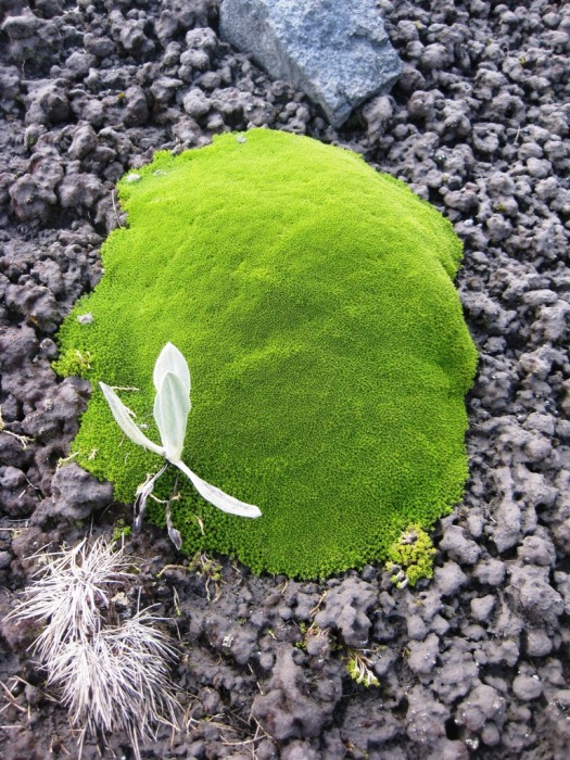
The approach to the Illiniza climbing refuge was the perfect intro to Ecuador's paramo vegetation.
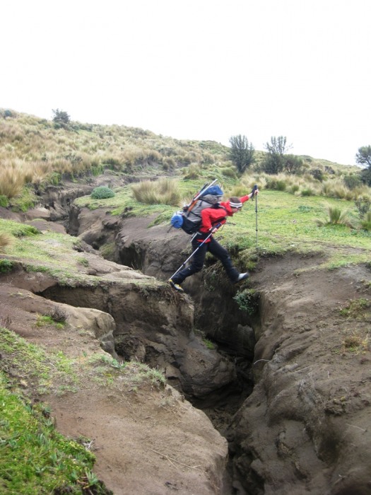
A dirt crevasse?
We bounced up the trail, admiring the creeping cloud formations and foreign avian fauna. We found the Refugio in rough shape, renovation 'they' claim. Expect to sleep on the floor. The propane stove is money and water can be found if you do a bit of investigation.
We felt quite good for heading straight to 15600' just 36 hours out of Denver. A lazy alarm clock had us spinning our wheels up the standard ridge route of Norte the following morning.
Looking at a Frosty Norte
On the ridge, the Refugio below
The terrain on Norte reminded me of a San Juan Peak, crumby old volcano. The dirt froze into a strange matrix of ice which exploded beneath our boots. We didn't know it at the time, but we had the best climbing-day-weather of the trip on this outing. All the high glaciated volcanoes were visible from Cayambe to Chimborazo. Bienvenidos!
The paso-de-murte is a class 3 traverse/downclimb, don't take a spill, the name could ring true.
More traversing takes you through loose dirt to one of two gullies (you choose).
The further North seemed easier, our choice.
Some class 3 scrambling, reminiscent of a short Pyramid NE ridge route, leads to a small exciting summit.
We had first class views of Sur and Cotopaxi.
Feeling no need to rush off, we spent an hour and a half up there.
So summing up Illiniza Norte? My pre-conception was - "climb it to get some acclimatization, but don't expect much more than that." Well, it was worth every step. A fun day!
That night, it hailed for hours and then snowed for a few more. We still went after Sur, you know, to take the tools for a walk. An earlier start had us on the glacier at first light.
After a traverse of moderate steepness, we climbed a 50' pitch of exposed class 3 and 4 crumbling rock. I belayed Debbie here for a good reason, take heed. Now on the east face, we started navigating up the steep glacier filled with various obstacles.
Hidden crevasses, avalanche debris, exposed glacial ice... good fun.
The route passes to the left of an impressive ice cliff, and then overcomes a smaller ice fall with an ascending traverse to climber's right. The weather had come in by now, we had periods of 5 meter visibility.
I truly enjoyed poking about, finding the route, finding holes and climbing high with ice tools. We started placing pickets in 30 meter intervals as soon as we passed the initial prominent ice cliff. Once on the ramp below the summit cliffs, we started placing wands as well. The crux pitch to the summit started with a dicey snow bridge over a ‘schund, and then went into a sustained 55 degree firn climb to the summit ridgeline. The snow improved as we went higher, providing for better and better picket placements. Just as we topped out, it started to snow so we started back down the route in short order. Off with the crampons as the snow was really balling by now.
The down was uneventful, if such an exciting outing could ever be described as uneventful.
The sketchy downclimb off the east face now held a fresh coat of snow, so we rapped.
Stepping back on to the moon-like volcanic landscape from the snow, we felt a rush of excitement. This route was a moment of progression for Debbie and I as a climbing team. We completed an unmarked technical glacial route (normal route, IV-/AD+) in less than ideal conditions, what fun!
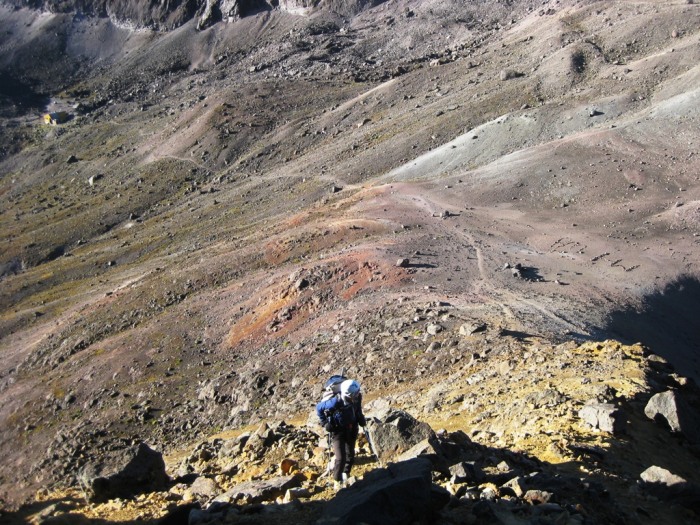
After bounding back down through the paramo in a downpour, we met up with our radio summoned truck and before long found ourselves at the base of Cotopaxi, a most finely tuned cone ready to explode. The trip was going smoothly.
These are the coolest mountains! It must be (still there?) an incredible adventure. It just must have been so much fun to be climbing glaciers in that weather - you‘re glad to have had the wands, right! :twisted: Sweet!
Well done report! I‘m envious because I tried Sur back in the early 90‘s and the night before our summit bid most of our team got sick (altitude and Montezuma‘s Revenge) and I followed suit the next morning, no summit. Anyway, congrats on a great report and accomplishment!
It is amazing how many factors have to line up just right to get a more involved peak, many out of your control. We experienced this on Chimbo. Guess they will always be there, since both Sur and Chimbo are extinct. Cotopaxi, which it looks like you got, may not be :wink:
Love the photo of glacier-covered Sur through the misty clouds. It is other wordly. And the paramo - very cool. Enjoyed the report of area I know little about. Thanks.
Joe I love the reports and photos you post. Heard a lot about it from Debbie also but nice to read your descriptions!! Cool pics!
Caution: The information contained in this report may not be accurate and should not be the only resource used in preparation for your climb. Failure to have the necessary experience, physical conditioning, supplies or equipment can result in injury or death. 14ers.com and the author(s) of this report provide no warranties, either express or implied, that the information provided is accurate or reliable. By using the information provided, you agree to indemnify and hold harmless 14ers.com and the report author(s) with respect to any claims and demands against them, including any attorney fees and expenses. Please read the 14ers.com Safety and Disclaimer pages for more information.
Please respect private property: 14ers.com supports the rights of private landowners to determine how and by whom their land will be used. In Colorado, it is your responsibility to determine if land is private and to obtain the appropriate permission before entering the property.


")
")
")
")
")
")
")
")
")
")
")
")
")
")
")
")
")
")
")
")
")
")
")
")
")
")
")
")
")
")


