Download Agreement, Release, and Acknowledgement of Risk:
You (the person requesting this file download) fully understand mountain climbing ("Activity") involves risks and dangers of serious bodily injury, including permanent disability, paralysis, and death ("Risks") and you fully accept and assume all such risks and all responsibility for losses, costs, and damages you incur as a result of your participation in this Activity.
You acknowledge that information in the file you have chosen to download may not be accurate and may contain errors. You agree to assume all risks when using this information and agree to release and discharge 14ers.com, 14ers Inc. and the author(s) of such information (collectively, the "Released Parties").
You hereby discharge the Released Parties from all damages, actions, claims and liabilities of any nature, specifically including, but not limited to, damages, actions, claims and liabilities arising from or related to the negligence of the Released Parties. You further agree to indemnify, hold harmless and defend 14ers.com, 14ers Inc. and each of the other Released Parties from and against any loss, damage, liability and expense, including costs and attorney fees, incurred by 14ers.com, 14ers Inc. or any of the other Released Parties as a result of you using information provided on the 14ers.com or 14ers Inc. websites.
You have read this agreement, fully understand its terms and intend it to be a complete and unconditional release of all liability to the greatest extent allowed by law and agree that if any portion of this agreement is held to be invalid the balance, notwithstanding, shall continue in full force and effect.
By clicking "OK" you agree to these terms. If you DO NOT agree, click "Cancel"...
As mentioned in my Mt Shasta report, this trip was done through REI Adventures. After leaving Mt Shasta City on July 21st and making my way down to Lone Pine, I had 2 days free before meeting up with the guides for the Whitney climb. So, I had a chance to take some pics of the Sierras. Here's one showing Whitney in the distance:
Day 1:7-23-08
The first day actually began with a 6 PM meeting time at Horseshoe Meadows Campground. We met up with the guides and other trip participants for gear checks, group gear distribution, and dinner -- then to camp at 10,000 feet to help flat-landers acclimatize. It was also a great opportunity to meet each other and our AWESOME guides JB (James Brown --forget the jokes, he's heard them all ) and Mike Imperial with Sierra Wilderness Seminars.
Day 2: 7-24-08
Today, we head down to the Whitney Portal Trailhead, stow stuff as needed in the bear boxes, and head out for our high camp at Upper Boyscout lake. The beginning of the route is on the Whitney Portal trail, but we turn off onto the North Fork of Lone Pine Creek trail right before the second creek crossing. Here's a waterfall right at the trail junction:
The skies were an unbelievable shade of blue. We were ascending a long gully. Here's a shot looking up toward the top:
The trail was quite easy to follow so far. JB said SAR had done a bunch of work in the last few years after a number of rescues from the ledges when climbers got off trail. We had a bit of easy scrambling to reach Ebersbacher ledges. Mike and JB did an awesome job guiding us through the ledges -- and giving guidance and encouragement for those in the group who hadn't done any climbing. Here's a shot looking down from the start of the ledges:
Here's one looking back to the valley as we begin to traverse the ledges:
We stopped at Lower Boyscout Lake for lunch ..check out the blue skies!!:
We had some slabs to cross on our route. There were very low angle, but with wet boots, I didn't like them much:
And we reach camp at about 11,500. Here's a shot of camp -- not exactly the moonscape we had on Shasta!!:
Here's a view from camp -- showing our summit poking through the gap:
Day 3: 7-25-08
After a 3:30 wake up call, we had downed some oatmeal and hit the trail. Our first objective was the top of the saddle to lead us around the ridge to Iceberg Lake. Once over the saddle, we got a nice view of our peak .. of course . .the sun wasn't quite up yet .. it's trying:
There she is with the alpenglow!:
At Iceberg Lake, we topped off water .. and took a pic or 2 -- there's our peak . .with those amazing blue skies!!:
From Iceberg Lake, out next objective is to scramble up a gully toward the notch at the ridge. In the above pic, that line of snow is at the far left in the gully. The notch is very prominent when you look at the peak and obvious once you get to Iceberg Lake. The gully is a mix of loose junk and nice solid granite .. it can be an ankle-buster for sure!! Here's a shot from part way up the gully:
And now again as we are closing in on the notch .. the sky really was THAT blue!!:
Mike did and awesome job route-finding for us in the gully! And JB worked with Susan, encouraging and guiding her up the gully. She had been uneasy the day before and was unsure if she could do it. She kept on coming!!
Here's a shot looking back from the notch toward Iceberg Lake:
From the notch, we basically turned left and had a 500 vertical scramble up another gully to the summit. The bottom of this gully was essentially a drop off .. so the exposure was pretty huge. So .. bonehead that I am ... didn't take any pics looking up from the notch to the summit ... so ...next pics are from the summit. With the exposure, we roped up for this part. We were all short-roped and Mike free-climbed it, then belayed us up while JB climbed along. We did two pitches on anchored belay, then Mike did a running belay from the summit for the final pitch. Hmm . the toughest Colorado peak I've done so far is Crestone Needle ... It didn't seem that tough, but I'm thinking I was glad to have the rope!! Linda would have loved this!! Here's Susan's arrival at the summit!!:
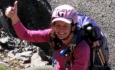
And the crew obliges me for a Tiger Paw shot:
And finally .... This little guy is Bedonk -- one of the marmots that lives at the summit of Mt Whitney. Nope .. we didn;t feed him to get him to pose .. but JB and Mike seem to know him pretty well!!:
Our summit day was about 12 hours or so. After our arrival back at camp, Sherrie convinced me to go for a cooling dip in Upper Boyscout Lake. That has to be the most refreshing thing I have ever done after a long, hot hike ... and no .. I have no pics of that
Day 4: 7-26-08
We packed up and headed out, then down to Lone Pine for a "large marg" -- wait ... the Mexican restaurant didn't serve margaritas!! What?!!! We settled for beers instead ... nothing like a nice cold one after a climb!!
Many thanks to JB and Mike for awesome guiding! I shall be back for more of those Sierras!!!
And thanks to Sherrie, Susan, and Dave for joining me on this adventure!! It was great meeting you and I hope you will come to Colorado sometime and try out some of our awesome mountains!! And I shall do more of those after summit dips!!
Thumbnails for uploaded photos (click to open slideshow):
Thanks Kevin. This was certainly the way to go! It seemed harder than Crestone Needle to me. There was some class 3 stuff, but mostly it seemed more like class 4 to me. No one else in the group had done any climbing at all and it was pretty exposed. They said most people don‘t rope up. Since this was my first scramble after my experience on the Needle, I didn‘t even ask about not roping up -- there were certainly some sketchy moves.
For anyone interested, here's a link to my Flickr albums for Shasta and Whitney -- lots more pics and for Whitney in particular, I tried to take more that would help show the route -- http://www.flickr.com/photos/29212115@N04/sets/
edit -- it doesn‘t seem to be picking up the entire link when I post this -- might want to paste in
Nice job, Monique! I have always wanted to get back and try the Mountaineer‘s route on Whitney some day. How did that route compare to other class 3 14er routes in CO? It seems like overkill that the guides would make you rope up for a class 3 route, but I guess better safe than sorry if there were people uncomfortable. I attempted class 3 Muir off the standard route for Whitney when I was just getting into scrambling and couldn‘t find a class 3 line. I think all of the class 4 CO 14ers would be rated class 3 in CA.
Caution: The information contained in this report may not be accurate and should not be the only resource used in preparation for your climb. Failure to have the necessary experience, physical conditioning, supplies or equipment can result in injury or death. 14ers.com and the author(s) of this report provide no warranties, either express or implied, that the information provided is accurate or reliable. By using the information provided, you agree to indemnify and hold harmless 14ers.com and the report author(s) with respect to any claims and demands against them, including any attorney fees and expenses. Please read the 14ers.com Safety and Disclaimer pages for more information.
Please respect private property: 14ers.com supports the rights of private landowners to determine how and by whom their land will be used. In Colorado, it is your responsibility to determine if land is private and to obtain the appropriate permission before entering the property.


")
")
")
")
")
")
")
")
")
")
")
")
")
")
")
")
")
")