| Report Type | Mini |
| Peak(s) |
Unnamed 13048 - 13,048 feet Buckskin Benchmark - 13,381 feet Unnamed 13015 - 13,015 feet Unnamed 13350 - 13,350 feet |
| Date Posted | 06/05/2026 |
| Modified | 06/06/2026 |
| Date Climbed | 06/01/2026 |
| Author | VeraUndertow |
| Overshadowed and Unnamed |
|---|
|
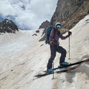
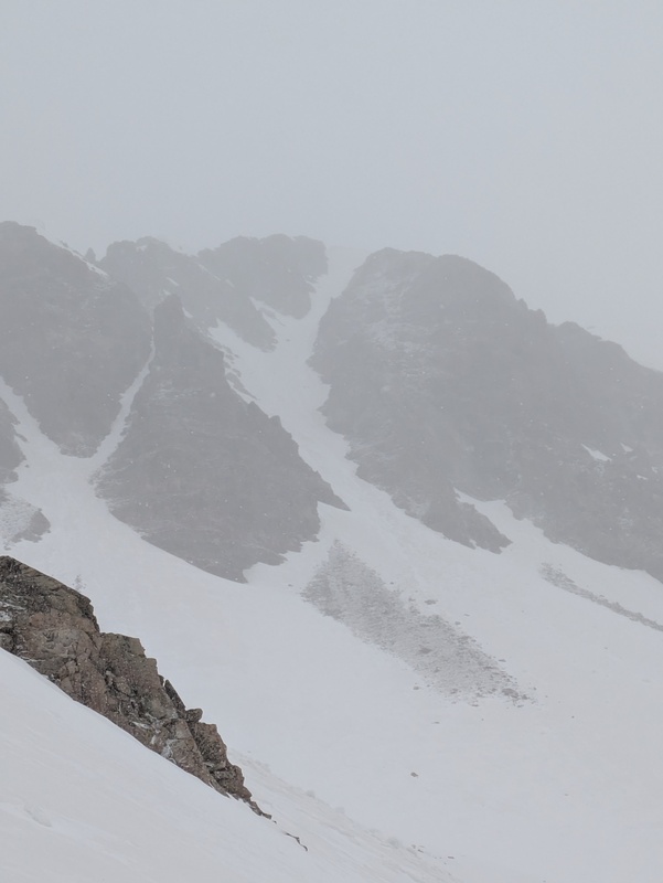
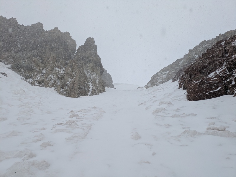
Skiing 4 Overlooked Elk Peaks This report is to share some skiing stoke and shine some light on this chain of peaks with rad lines, that somehow only have a total of less than 10 descents on here combined. This spring was a weird one for us 13er skiing kooks, it looked like not much was gonna be in after a warm cycle at the end of March melted out a lot of the already low snowpack. Then April and May delivered a fair amount of snow to shape up some lines, and Aspen faired better than most areas, so I made it my goal for the season to get back into this area and ski some peaks that have great ski lines I've been eyeing, but not a lot in the way of ski beta. May 18th - Minnehaha Gulch - Un 13,048 With the forecast calling for snow all day, I set my sights on the low hanging fruit of the chain of peaks north of Sleeping Sextant, the fun little unnamed peak 13,048, which has a cool looking curving couloir on topo that tops out just north of the summit aiming South then curving to the SE. With no risk of warming, and the chance of snow starting around 7 and increasing throughout the day I started at a leisurely 6:30 AM, hoping I could be up high early enough to avoid major avalanche problems but late enough to ski a little fresh snow, to make the skiing a little bit more fun. I headed up the all too familiar trail towards Crater Lake from Maroon Lake, and turned up towards Buckskin pass at the trail split. There was some intermittent snow starting just before the trail split for North Maroon that had not frozen solid the night before and it became quite tedious to post hole thru, but still not consistent enough to skin. So I left the trail at 11,100 ft and put on boots and skis and followed an obvious gully up towards the saddle of Sextant and 13048. Once at the top of the gully I angled more north traversing around the basin towards the bottom of the couloir on 13048, which I am calling the Minniehaha Couloir (unless someone knows of an existing name for it) I was able to skin up to around 12,400 feet at the base of the couloir, before transitioning to crampons and booting up the last 650 or so feet. The couloir is a moderate snow climb, by my ratings, not too steep by any means, and was full of wet slide debris on this day, from a recent shedding cycle. Near the top, the couloir split with one part going to the south side of the summit and the main line heading more north as I climbed. I thought about checking out the south side, but decided to just stay with the main, as it looked to take me right near the summit. As I topped out I saw a large but not really overhanging cornice, I skirted to the right, then topped out on, which brought me to one quick class 3 move, then the summit. It had been snowing pretty hard since I put my ski boots on an hour + ago and I was hoping some fresh snow would make skiing the wet slide debris a little more fun, unfortunately it was also reducing the beautiful view from this summit to the inside of a ping pong ball. I transitioned and dropped around 9:45 AM, and found the line, not too spicy with a few good turns here and there. at the bottom of the line I traversed hard to skiers right to head back down my ascent gully, which I was able to reach with limited side stepping but staying high as I traversed. This lower gully was half wet slide debris and half smooth, now covered in 2-3 inches of blower pow, and was honestly some of the most fun turns of the season for me. As this line flattened out I went to where I stashed my shoes then headed further skiers right (south), aiming for the north maroon trail split, I found a few more good turns but the snow was getting thinner and I had to cross a few dry patches as well. I was able to make it to the creek crossing at the trail split for N Maroon where I transitioned back to trail runners and hiked out to the trail head, arriving around noon. This line was perfect for the days conditions and I was genuinely surprised to see no reports or marked descents on this site or elsewhere as it is a pretty easy day and a fun way to climb and ski this peak. 

June 1st - Willow Lake Basin Triple - Buckskin BM, Un 13,015, Un 13,350 Another morning at maroon lake trailhead, this time I pulled in a little earlier, and got started at 5 AM. Made my way up to Buckskin pass, the snow had melted out much higher since the last time I was here, and with a solid overnight freeze I was able to make it all the way to the top of the pass without too many post holes. From there I was able to walk on dry ground all the way to the summit of Buckskin BM. I've had my eye on a few different lines on this peak since last season, and was able to see the two east facing ones earlier in May but I wasn't super sure how they were holding up at this point. The first one is a very fall line, east facing line south of the summit and it was extra thin and nasty looking with wet slide debris and rocks in it. The next one looked to be the best true summit ski line and is also east facing from just north of the summit. I couldn't tell if the bottom was continuous from the summit, so I headed to the north to scope the north face and the bottom of the primary summit ski line, I was a little bummed the north face wasn't quite in continuously, as it has been my phone background since I skied Willoughby in May last year, and I would have loved to ski it, since it had the smoothest snow. I was able to see the primary line was in with just a very brief rock crossing near the bottom in low consequence terrain. I dropped in at 8:50 AM and the snow was already softened up quite nicely, which was great news since it was not anywhere close to smooth in this line and there was a pretty spicy narrow choke to contend with right off the top before it opened up. I actually enjoyed the ski more than I was expecting and was able to avoid most of the rocks and super chunky wet slide debris in the line. I was able to ski all the way to 12k, with just two small rock crossings, where I met up with the East Snowmass Trail, 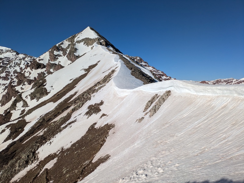


From here I transitioned to walking on dry trail in my ski boots for a couple hundred feet, before reaching the snow in the basin between Un 13,015 and Un 13,350. My initial plan was to climb the south couloir on 13350 and ski the the north east couloir, then boot back up the NE Couloir and ski the south couloir, before heading up 13015. Unfortunately the south couloir did not look like it would be worth skiing so I adjusted my plan to ski 13015, and then ski 13350 and come back up the Willow Lake Basin east of 13350. I started postholing at around 12,300 ft, so I switched to skinning and skinned till around 12,650 ft, before switching to booting my way straight towards the summit ridge. Near the very top the snowpack got thin and I was sinking in further than I liked so I aimed for the rocks to go the last 50 feet up to the summit ridge, before following the ridge back around to the true summit. This face was really wonderfully filled in except for a small rock band poking thru the snow I avoided by aiming towards the dry rocks, and I couldn't help but wonder what it would have looked like on 5/18 when I had initially hoped to ski this link up. Such is life, and moving in the mountains tho, and I was happy to have 700 feet of smooth corn to ski just below the rocks. These were some super nice, ripping corn turns and I had a blast making big GS turns down, I think the whole descent took 1 minute after I got past the rocks. 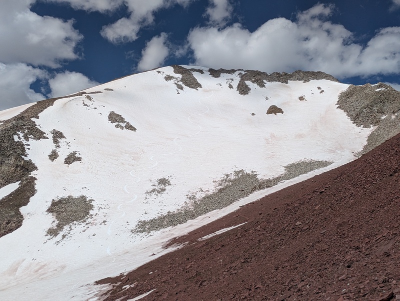
I transitioned again to booting, and ate a snack as I could tell this was gonna be a grind of a climb, with snow, mixed snow and rocks and finally rocks, that looked quite loose near the top. It was around 10:30 when I began up and the first 400 feet went pretty smoothly, before I hit the mixed snow and rocks, which were unpredictable and had me punching thru to my knees in places, and trying to balance on wobbly rocks in others. I hit another field of nice solid snow and cruised up that for another 200 feet, before hitting the dry top of the couloir which would take me the last 250-300 feet to the summit ridge. This part of the couloir reminded me of the south facing gully on Hagerman, which was not an exceptionally fun route in my opinion, though I found this one the be a little less treacherous overall, I was happy I was climbing alone for this part. I eventually topped out and climbed up to the summit of this peak around 11:35 AM. I was stoked to see the line I came all this way for, was still in, and the lower basin was holding a fair amount of snow as well, so I could get a nice long ski descent out of here. I transitioned at the top of the line and cut across the top of the couloir, releasing a small amount of snow, which I was happy to see it wasn't too wet and gross yet. Skiing a northeast facing line at around noon on a mostly sunny day, with 40 degree temps is definitely a little later than my preference, but as the situation changed I had to adapt, and I was thankful for the solid overnight freeze, sporadic clouds and breeze that helped keep it as cold as it was. Dropping in I had 4 or 5 really smooth turns that I felt I could absolutely rip before the snow started to have wet slide debris pockets in it, from there I made sure to savor the turns, as I don't think I will be back to this line anytime soon. Not because it's not worth repeating, but it is such a journey to get back here. As I skied out, I saw a bunch of snow still clinging to the north aspects on the south side of the basin, so I traversed over to that side and was able to ski down to 11,550 ft, nearly 1800 feet of continuous skiing is a treat this time of year. 
Another transition, this time to trail runners as I saw a nice trail leading around the east side of 13350 heading south, and I was hoping I could stay on dry ground long enough to make the switch back to shoes worth it. This trail split and was braided in places, but was very solid for a trail that wasn't marked on my caltopo at all. I followed it till I hit snow again at 11,850 feet as I headed south back up the basin towards Willow Pass. From here I switched to skinning and was able to loosely follow the Willow Lake trail back over Willow Pass, the snow was amazingly supportive here still, even at 1:30 PM in a hot, sunny basin. I was able to look back at 13015 and the east face of Buckskin BM again as I skinned all the way to the top of Willow Pass. From the top of Willow pass I descended around 200 feet on dry trail, before hitting snow again and putting my sliding sticks back on for another 500 feet of descending. This time back to the trail for Buckskin Pass, where I met up and was able to ski to just below the split of the willow lake trail. A final switch to trail runners, and I was heading back to maroon lake, I didn't see any one else until I reached the Crater Lake Trail, then I saw a whole bunch of people, who always ask the best questions. My favorite is always when people ask if I found any snow, while looking at a bunch of snow on the Maroon Bells. I made it back to the trail head just before 4 pm, changed into comfy clothes and headed back towards home in Denver, very happy with how everything had worked out today. Thanks Maroon Bells Wilderness for providing some lovely skiing and beautiful solitude in one of the most visited trailheads in the state, and thanks to you for reading this far, I hope this inspires a few people to get back there and ski these cool peaks. 
Ski edit of Willow Lake Triple I don't record my track usually, but a roughly drawn line on Caltopo estimated this day was 7,000 feet of vert and 15 miles, which feels about right. Thumbnails for uploaded photos (click to open slideshow):  Lower ascent gully on 13048, from Buckskin Pass Trail")
 Minnehaha Couloir")
 Some wet slide debris as I head up the couloir")
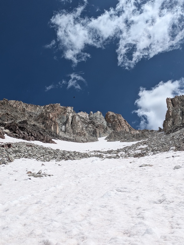
 The top out of the Minnehaha Couloir")
 Buckskin Pass looking south, some big cornices, I was able to avoid by leaving the trail to the north")
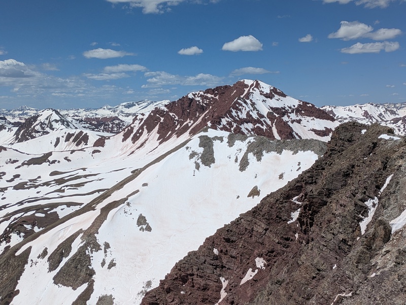
 My line on Buckskin marked in green, south of summit couloir to the left.")
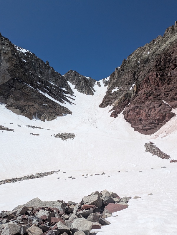
 North East Couloir on 13350, in and beautiful")
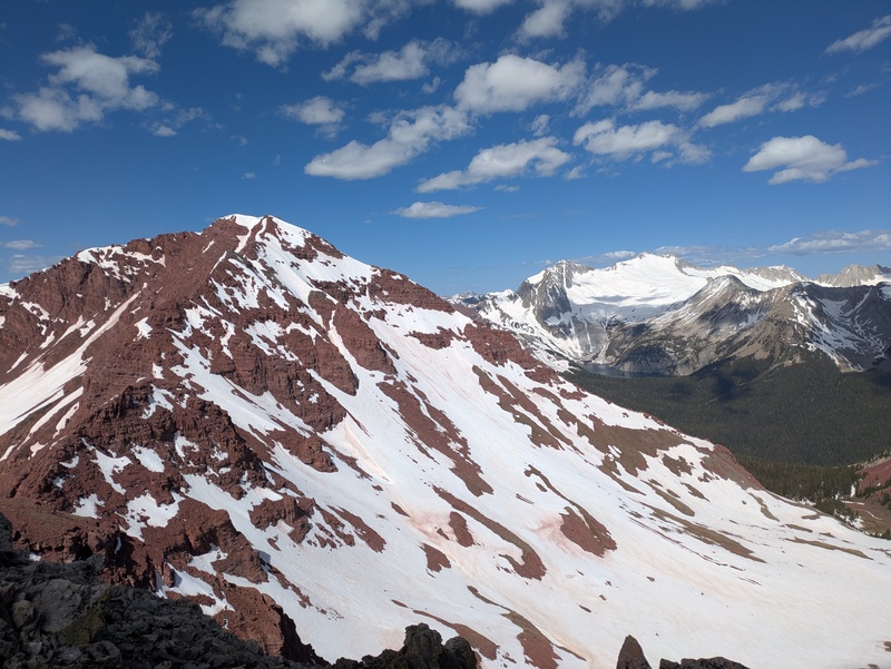
 As I climbed 13350 I got a great view of 13015 (front and gray) and Buckskin BM (behind and red)")
 My turns on the north face of 13015")
 Not quite in, north face of Buckskin BM")
 From the top of my ski line on Buckskin BM.")
 Willow pass")
 Sad looking south couloir on 13350, it went enough to climb tho")
 In the south couloir of 13350")
 This photo was taken 6/6/23 from lightning pyramid for better reference of what you could expect in a more average snow year.")
|
| Comments or Questions | |||||||||
|---|---|---|---|---|---|---|---|---|---|
|
Caution: The information contained in this report may not be accurate and should not be the only resource used in preparation for your climb. Failure to have the necessary experience, physical conditioning, supplies or equipment can result in injury or death. 14ers.com and the author(s) of this report provide no warranties, either express or implied, that the information provided is accurate or reliable. By using the information provided, you agree to indemnify and hold harmless 14ers.com and the report author(s) with respect to any claims and demands against them, including any attorney fees and expenses. Please read the 14ers.com Safety and Disclaimer pages for more information.
Please respect private property: 14ers.com supports the rights of private landowners to determine how and by whom their land will be used. In Colorado, it is your responsibility to determine if land is private and to obtain the appropriate permission before entering the property.