| Report Type | Full |
| Peak(s) |
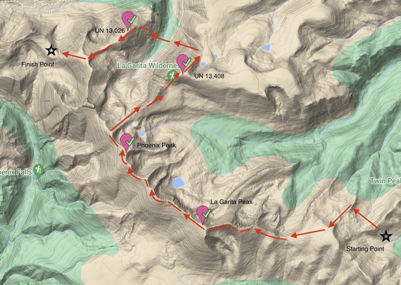
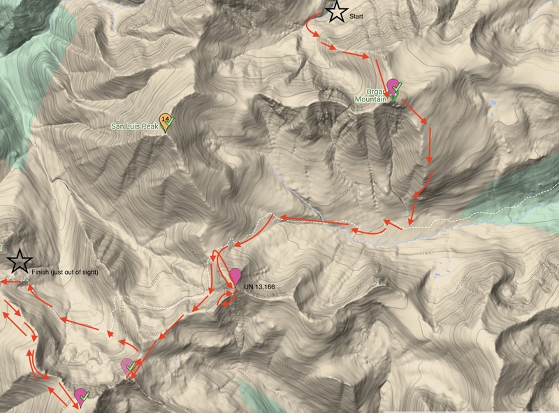
La Garita Peak - 13,725 feet "Phoenix Peak" - 13,904 feet Unnamed 13408 - 13,408 feet Unnamed 13026 - 13,026 feet Unnamed 13166 - 13,166 feet San Luis Peak - 14,023 feet Baldy Alto - 13,703 feet "Column Ridge" - 13,798 feet Baldy Chato - 13,417 feet Stewart Peak - 13,988 feet |
| Date Posted | 04/18/2025 |
| Date Climbed | 06/11/2024 |
| Author | katielyons |
| Additional Members | gunnison_garrett14 |
| The La Garitas Traverse |
|---|
|
The La Garitas Traverse - June 10-June 15, 2024 Nestled between the sleepy mountain towns of Lake City and Creede lies the La Garita Wilderness, a nearly 130,000-acre expanse to which one 14er and twenty-one 13ers call home. When my partner Garrett suggested that we tackle all the peaks in the range in a single unsupported push, I excitedly agreed to the idea, having no idea what we were actually taking on. Here’s a look at the good, the bad and the talus the range had to offer. Day 1 – June 10, 2024 11.54 miles; 2841’ elevation gain Note: This day doesn’t include any peaks. Skip to day two if you’re looking for beta. Garrett and I left Crested Butte around 7:30 a.m. and made our way south to begin our traverse across the La Garitas. A skillful and creative route planner, Garrett suggested that we stage one car at Spring Creek Pass, drive the other to the Wheeler Geologic Area 2WD Trailhead, and do this hike as a one-way trip, maximizing the terrain we’d be able to cover over a week’s worth of time. He pitched the idea of starting at the Wheeler Trailhead because seeing the geologic area had been on our adventure to-do list for a few years and this seemed like the perfect way to incorporate it into our trip. We arrived at the Wheeler Trailhead around 11 a.m., heaved our packs filled with a week’s worth of food and camping gear onto our backs, and started down the trail. As far as gear for this adventure, we had decided to reassemble the ultra-lite backpacking kits we had used a year ago for our second thru-hike of the Colorado Trail. 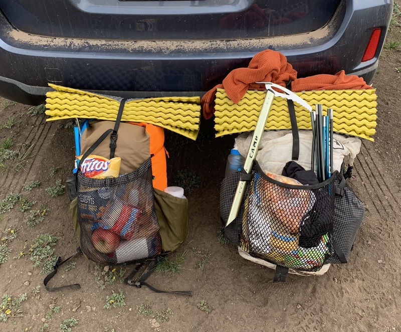
In my 40L Hyperlite pack, I carried an 18-degree sleeping bag, a Therm-A-Rest XTherm sleeping pad, a Z-Lite foam pad (I sleep really cold), as well as a puffy jacket, a few pairs of underclothes (including a pair of socks for every day; a lifesaver), basic toiletries, 2L of water carrying capacity plus one Katadyn BeFree filter, a headlamp, a battery block, the stakes and poles for our Nemo Hornet two-person tent, and a few charging cords. Garrett’s pack was almost identical in terms of contents, but he also carried our tent body and rain fly, and as a warmer sleeper, he opted for a 40-degree bag, a Z-Lite pad, and a Therm-A-Rest uberlite sleeping pad (we both ended up being a little chilly at night on this trip). The hike into the Wheeler was beautiful and uneventful. We followed faint, but marked trails through mellow, grassy, sub-treeline meadows, crossed occasional creeks flowing with spring fullness on makeshift stick bridges, and tried our best to pick out the distant peaks we hoped to accomplish in the coming days. After about 6 miles of walking on trails, we reconnected with the Wheeler 4x4 road and had an easy stroll into the geologic area, where we were the only visitors at the time. Upon our 2 p.m. arrival, we were disappointed that it looked like we wouldn’t get to spend very much time admiring the otherworldly hoodoos for long; the surrounding clouds were growing dark and ominous, and we still had to make it up and over Halfmoon Pass, above treeline, that afternoon. 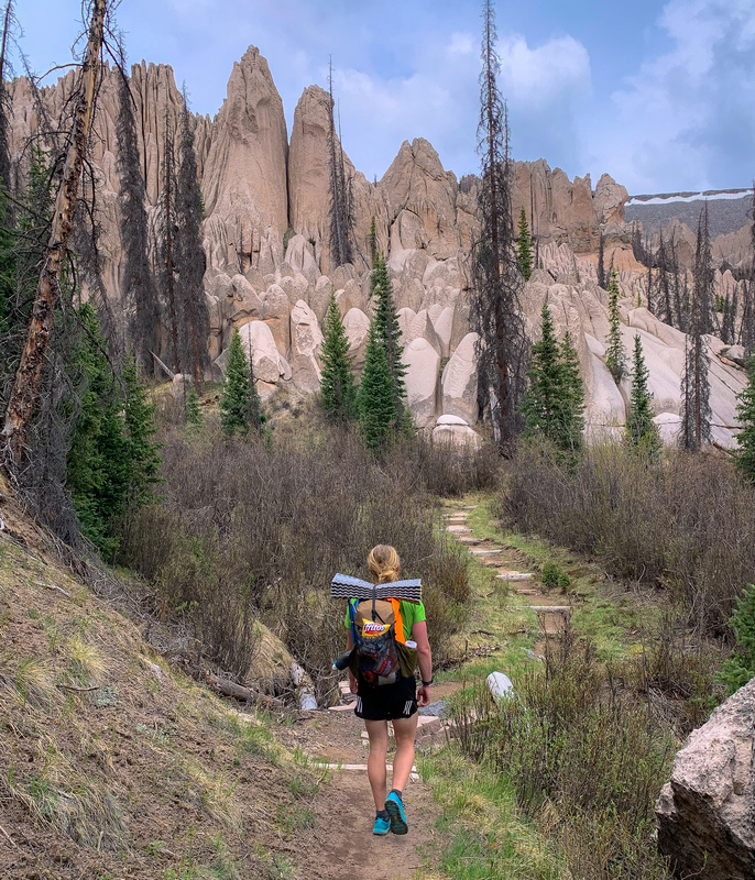
After chatting through our options, we decided that when we summited the pass we’d either follow the NW ridge from Halfmoon Pass directly to La Garita Peak if weather allowed (such as in this trip report), otherwise we’d continue over the pass and follow the established trail to Machin Lake where we could resupply on water. We heard a few distant rumbles of thunder and felt a few scattered raindrops as we ascended the pass, helping us make the decision to continue on the Machin Lake Trail rather than take La Garita Peak’s weather-exposed ridgeline. Upon arriving at the top of the pass, we encountered our first snowfield of the trip immediately on the other side. It was solid enough to walk on and we made quick work of descending to the trail, now buried under snow, a little further down to where it re-emerged again. Once on the trail, we encountered some dirt, lots of mud, and intermittent snow of varying postholiness. Meanwhile, the skies in the distance continued to grow darker. 
After a few miles of hiking, the wind started to blow harder, cooling the air, and we stopped to readjust layers. During our brief stop, we noticed we were right next to a relatively flat campsite just off trail, and since we couldn’t get a good gauge on what the weather was going to do, I suggested we pitch our tent and wait for the sky to get a bit clearer. We had just barely ducked into our tent when the clouds opened up and the rain started to pour down. Since it was later in the day, we figured the storms would pass in an hour or so and we’d have time in the evening to continue our hike. We took advantage of the unplanned downtime to read maps and familiarize ourselves with our proposed route for the following day. Day 2 – June 11, 2024 12.02 miles; 5945’ elevation gain Peaks Summited:
On our second morning of the trip, the sky was a brilliant, nearly cloudless blue and it appeared last night storms had passed in their entirety. We took a look at a map once again that morning and decided it was easily the most efficient option to gain a nearby ridge to summit La Garita and Phoenix Peaks, however, we also acknowledged that we might have to go all the way to Machin Lake to get water. 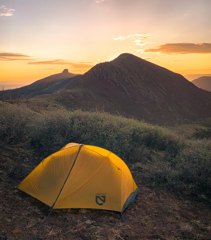
We packed up our camp, hopped back onto the trail, and as luck would have it, found a runoff stream about a quarter mile away from where we had pitched our tent the night before. Here, we were able to fill our water bottles and do some easy bouldering on a fun rock formation. Fully resupplied on water for the day, we deviated from the trail about a half mile from our starting point to gain one of La Garita Peak’s east ridges, grateful to pursue the more efficient route option. 
After an easy initial climb up grassy tundra, we arrived at La Garita’s sub-summit which connected to the true summit via a somewhat narrow class 2 ridge composed of large talus blocks, each separated by deep fissures. Some of these cracks extended so far down it was impossible to see the solid ground that held them up, making this traverse more high-stakes than it would’ve been otherwise. As I navigated this terrain with my heavy pack, I struggled to move nimbly and took care to mind my every step and hand placement, lest I fall into a talus block abyss. Garrett, the mountain goat that he is, spryly hopped from block to block without so much as breaking a sweat, despite the heavy load he was also carrying. It was slow going for me through this section, and I was quite relieved when we encountered a sustained snow patch which at least meant I’d no longer have to move over these big blocks with my pack. 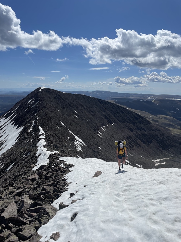
Upon reaching the summit a few minutes later, we signed the register, posted up in the small wind break for a snack, and then continued our journey, bearing northwest to Phoenix Peak. 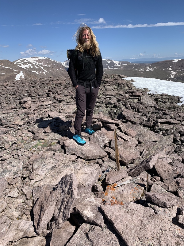
Though the mile-long, class 2 traverse to Phoenix from La Garita wasn’t particularly challenging, we were happy to only have to do it one way, which wouldn’t have been the case if we had stuck to our initial plan and made it to Machin Lake. 
Reaching the summit of Phoenix at mile 5.5 of the day, we hoped to sign the register but the summit register jar contained nothing more than a few damp, ripped scraps of paper and a pencil. 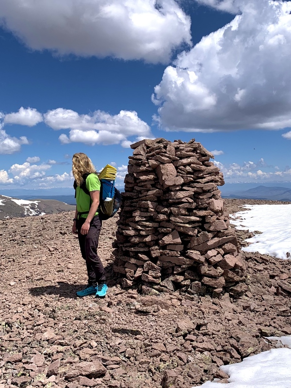
From the summit of Phoenix, Garrett pointed out our next peak for the day, Unnamed 13,408. It was at this point that my brain short circuited. Truthfully, I was already struggling quite a bit with the off-trail travel we had been on for almost the entire day and to see a summit that looked THAT FAR AWAY was disheartening to say the least. Moreover, the majority of the route looked to be on annoying, loose, class 2 talus which I had already begun to grow frustrated with. “This week will be like talus boot camp for you!” Garrett offered, jokingly. I did not laugh. I was starting to realize that I might have bitten off a bit more than I could chew on this trail-less trip. Regardless, it was only day two and I didn’t want to ruin Garrett’s fun, so I forged on, once again carefully calculating my every step on the descent from Phoenix to the adjacent saddle about a mile and a half away. 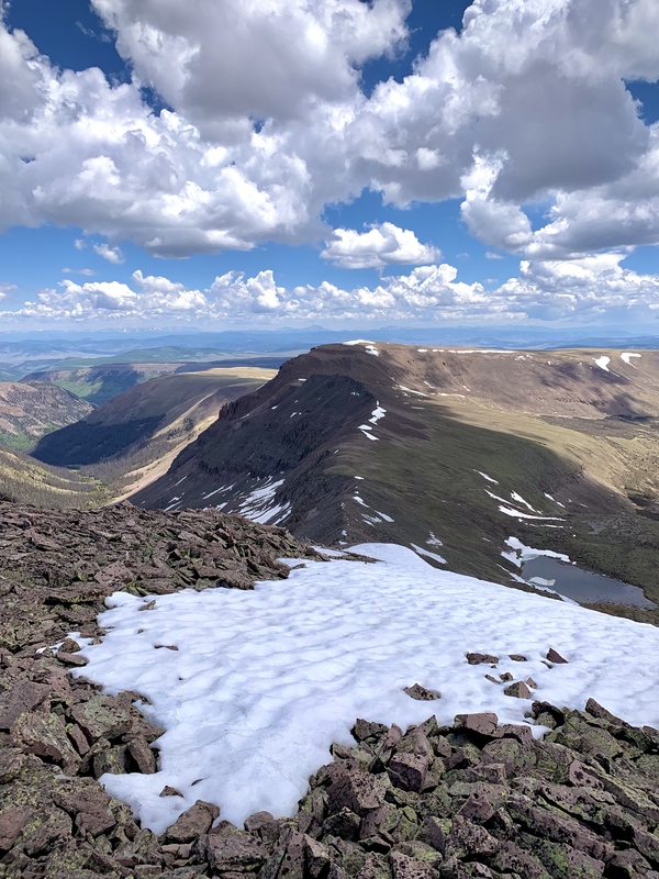

I plodded along, steadily chipping away at the terrain between Phoenix and 13,408, with Garrett patiently staying by my side all the while (though he could’ve gone much quicker if he were solo). We finally reached the flat summit of UN 13,408 at mile 7.4 for the day around 2:30 p.m. 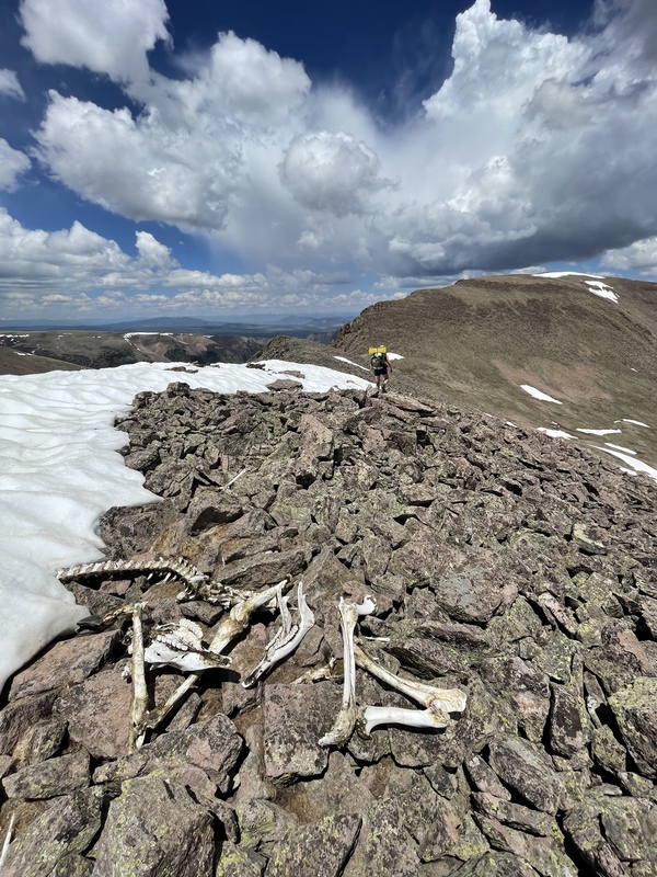
I was relieved to see the back side of this peak was much grassier than the side we had come from, but then I nearly jumped off the side of the mountain when Garrett pointed out the summit of the next peak on our itinerary, UN 13,026, in the distance. It looked even further than this peak had looked from Phoenix! By a lot! “We’ll descend down a gully, fill up water in the valley below since we won’t be camping near water tonight, then ascend up that avalanche path you see on the other side,” he said gesturing to a tediously steep slope on the mountain opposite from us. At this point, there was no way I was going to retrace our steps to go back the way we came (it looked like more talus in that direction than the direction we were going), so I took a deep breath and followed him to a large snow field which descended into the valley below. As we made our way down the valley, the snow patch transformed into spring runoff that created a lively, flowing stream of ice-cold water. The consistently class 2 route got steeper and the ravine got narrower as we descended, and ultimately it became more trouble than it was worth to continue straight down. We dodged into the woods to our left and tried, unsuccessfully, to pick out a game trail through the dense deadfall and thick underbrush. Around 4:30 p.m. after about 30 minutes of tiring bushwacking, I was relieved to see the valley bottom in the near distance. We crossed the river using downed trees and took time to rest and consider our options for the remainder of the day. 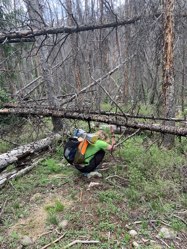
Part of me was crossing my fingers for a rainstorm to materialize in the sky above so we could pitch the tent and call it a day, but for better or worse, the weather held and we were able to continue on. Because we anticipated we wouldn’t encounter a water source for a while from here, we loaded up as much water as we could, with Garrett carrying five liters, and went ahead and made our freeze-dried backpacking dinners. 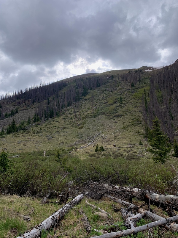
The avy gully we took to ascend UN 13,026, was, as expected, steep, overgrown, and exhausting after having already put in almost 10 miles and 4.5k+ of off-trail vert for the day. Not to mention the weight of the water we had just added to our loads. In addition, we could see the route to the valley floor down our previous peak, UN 13,408, that we coulda-shoulda-woulda taken if we had been able to locate it from above, which would’ve been a tricky challenge. We climbed up mostly grassy class 2 terrain for about an hour under the keen, watchful eye of a few elk, and reached the summit of 13,026 just after 6 p.m. From here, I was relieved that we were done summiting peaks for the day and all we had to do was stroll downhill into camp. Or so I thought. 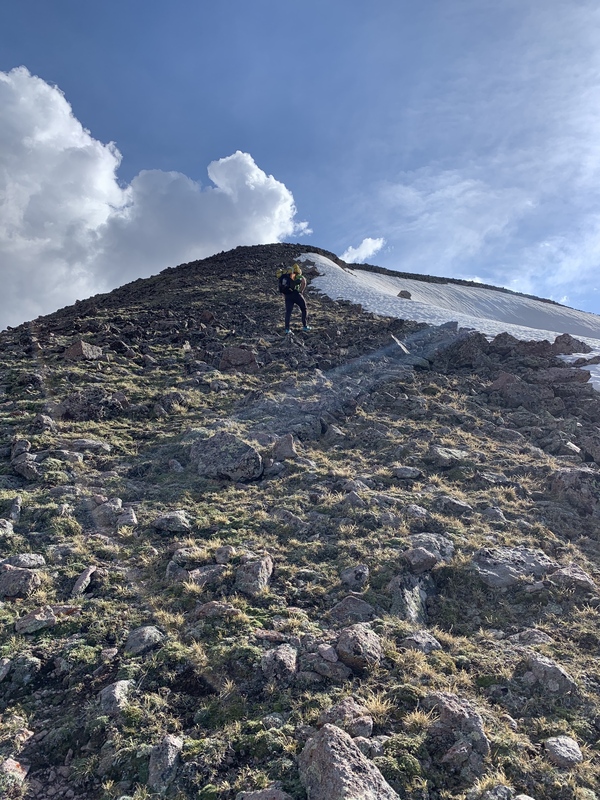
The saddle we hoped to camp on was wind-exposed without many flat options for laying out our sleeping pads, but there looked to be a much larger, flatter, more wind-protected saddle along the next ridge about two miles away. This expanse looked far more ideal for camping, but to get there we would need to go up and over a sub-summit, that was higher than our current peak. We dubbed this annoying sub-summit, “Not Peak,” hoisted up our packs, and forged onward. As much as I wanted to be done at this point, the thought of a good night of sleep was enough to keep me going and I trudged up and over yet another ridge to the summit of Not Peak. As a reward for making it to the summit of Not Peak, we were gifted a stunning, orange sunset that graced the skies behind San Luis, in addition to a well-trodden game trail to the saddle we were hoping to camp on. 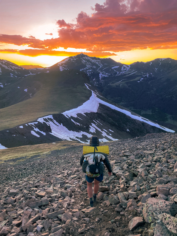
We rolled into camp just before 9 p.m., clocking a total of 12.02 miles and 5,945’ of climbing for the day, and laid out our sleeping pads and bags. It was my first night ever sleeping under the stars without a shelter, and I was lucky that on this particular night, there were lots of stars to enjoy. Day 3 – June 12, 2024 12.84 miles; 6325’ elevation gain Peaks summited:

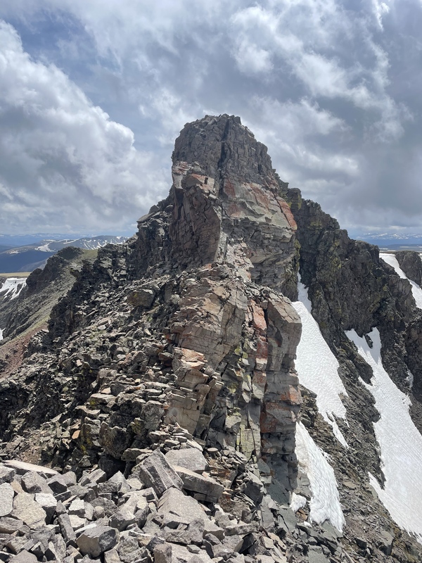
We again woke up to bluebird skies without a cloud in sight. Today, we were hoping to summit six peaks, our biggest push for the trip, so we packed up our gear and continued westward to new mountains. The first peak of the day was Unnamed 13,166 which was about a mile and a half away from where we had camped. We took to calling this summit “Hat Mountain” because the final summit block looked like a tiny top hat or fez worn by the otherwise unremarkable, rounded summit. The initial route toward this peak took us up and over another sub-summit which, if nothing else, was thankfully a little bit lower in elevation than Not Peak. After following some more game trails and going up and over another class 2 sub-summit, we gained UN 13,116’s ridge and climbed to where only the final class 3 crux remained. 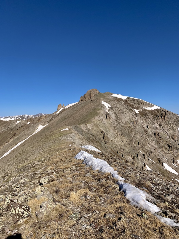
As a personal aside, I don’t do well with exposure. Like, at all. I had already told myself that if I didn’t want to do this final pitch that I would forgive myself and make peace with orphaning this summit. This was exactly what happened. We arrived at the summit block around 9am, and after ditching his pack near the base, Garrett scurried effortlessly to the top of the peak, utilizing the juggy hand and footholds to make it to the top. After watching Garrett and trying to muster up enough nerve to make it to the top, I steeled myself and did the first 60% of the summit scramble. However, after peering over the west side of the peak and acknowledging the airy, final moves, I opted out. The rock was bomber and I wished so badly that a fall here didn’t have a high likelihood of injury, but ultimately, my head/exposure game wasn’t there, and I knew I’d have to come back another time for this one. Oh well. I downclimbed the short pitch I had just ascended and watched Garrett, a real mountain goat, go up and down the summit pitch several times just for fun. After signing the register just below the previous day’s summiter, 14er legend Andrew Hamilton, he finally downclimbed back to me for the last time and we carried on toward San Luis. 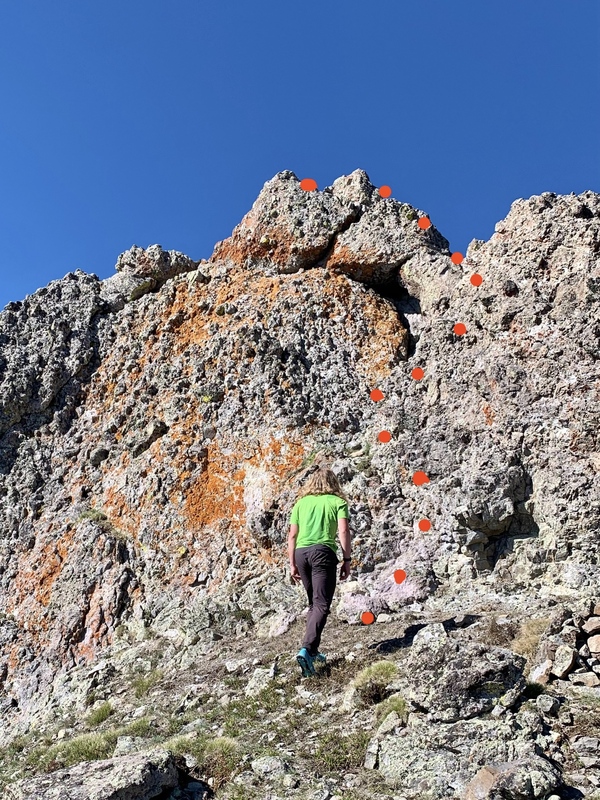
Upon reaching San Luis Pass about a half mile away from UN 13,166’s summit block, we took the class 1 trail up the south ridge to the summit. I was positively elated to be on an established trail and found a new gratitude for the mindless practice of walking uphill without needing to carefully plan my every step. 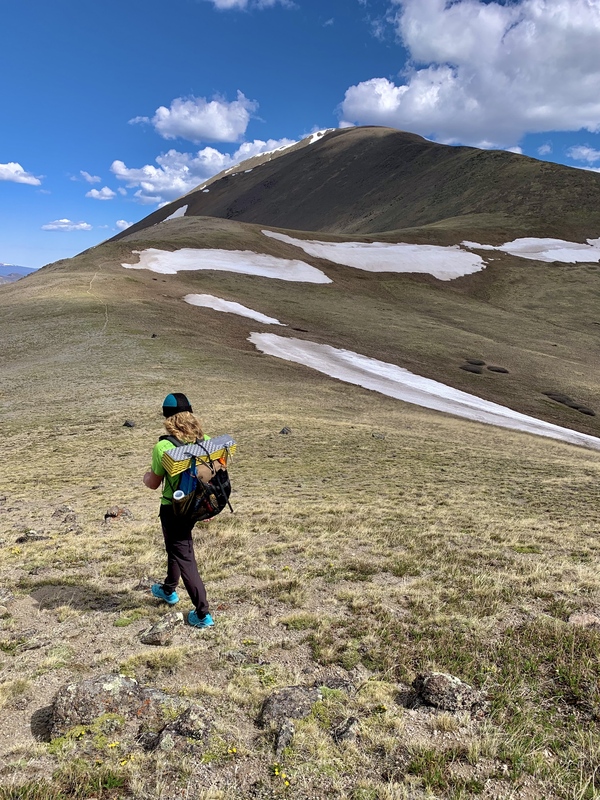
It was quite windy at the top so we didn’t spend too much time there after taking a quick photo to prove we made it. We then continued our journey down the backside of San Luis on the still class 1 trail toward our next summit, Baldy Alto. 
Even when we stepped off the official San Luis trail about a half mile down from the summit, the game trail leading toward Baldy Alto was excellently maintained and brought us exactly where we wanted to go (these elk and bighorn sheep trail crews really deserve a raise for their hard work). 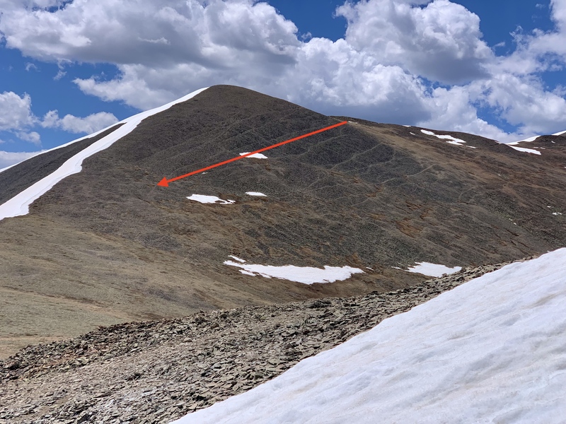
The trip to the saddle between Baldy Alto and San Luis was a combination of grass and class 2 scree, but the difficulty increased to unexposed (woohoo!) blocky class 2+ terrain once we started our final ascent to Baldy Alto’s summit. All along the summit ridge, we were surprised to find gorgeous agate samples all over the ground. The purple, blue, yellow and red rocks were littered everywhere, and I was really tempted to stay and rockhound instead of continuing our climb. There’s nothing I love more than a cool rock. However, I knew we still had four summits to go, so I pushed on, choosing the line of least resistance up the solid rock. The route was engaging, fun, and all-around enjoyable, making this my favorite summit for the trip. 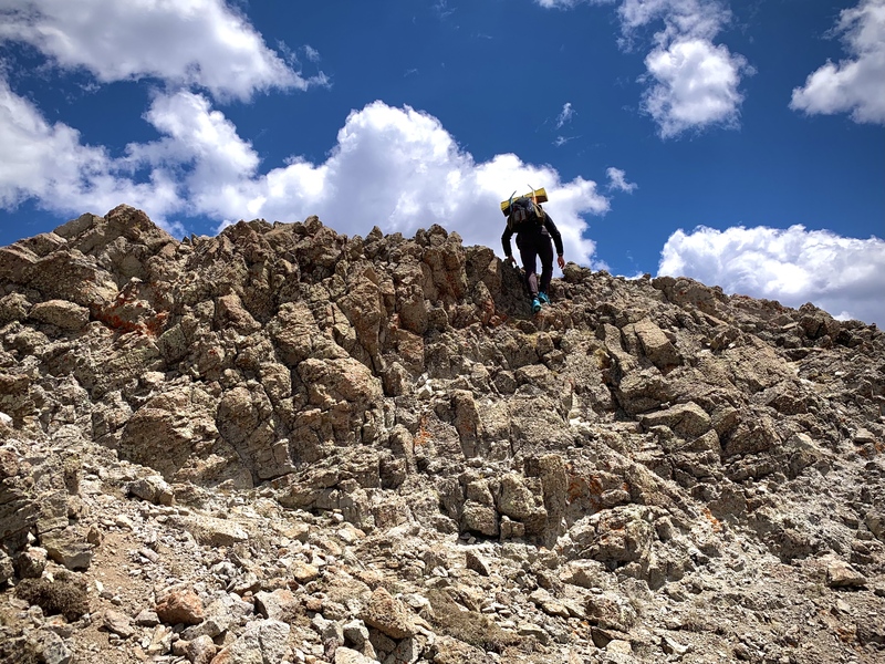
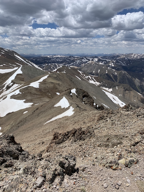
After signing the summit register, we continued down grassy slopes to the northeast toward our next summit, Column Ridge. The terrain was quite easy (entirely class 2), but boy was I disheartened when we popped over the final summit ridge that connected Column Ridge to Stewart Peak. It was here that I got my first glimpse of the peak we hoped to summit after Column Ridge, Baldy Chato.The summit looked so far away I may as well have been looking at a peak in the Sawatch. Luckily, the terrain we had encountered so far today was by and large easier than the big talus blocks we had traveled over the day before, so I was feeling tired, but up for the challenge. We summited Column Ridge around 2 p.m. and then began the long journey to Baldy Chato’s flat, distant summit, about two miles away one-way. 
There was a large snowfield on the north side of Column Ridge’s summit, and we debated whether to shoe-ski down or stick to dry terrain, and ultimately ended up doing a bit of both. Had we stayed on completely dry terrain the entire time, it would’ve been about a half mile of class 2 talus. 
When we reached the saddle between Column Ridge and Baldy Chato, I was relieved to see that, if nothing else, Baldy’s Chato’s summit was very flat and we didn’t have much elevation to gain from where we stood. Though the summit looked unimpressive from a distance, we were pleasantly surprised when we saw the dramatic, rugged terrain of the peak’s west flank. The crumbling, imposing rock towers stood in stark contrast to the peak’s grassy, low-angle slopes on the opposite side, and I decided that though tagging this peak was a pain, it made up for it with its impressive views. 
After reaching Baldy Chato’s summit, we began making our way south, back toward where we had come from. We soaked our shoes crossing through the grassy basin rife with small spring runoff streams, and our feet were thoroughly damp by the time we reached the saddle connecting Stewart Peak and Column Ridge once more. Though Stewart’s summit looked far away, it certainly didn’t compare to how far away Baldy Chato had looked, and I was pleased to find that the ridge climb was quite easy, even on tired legs, and didn’t exceed class 2 in any places. 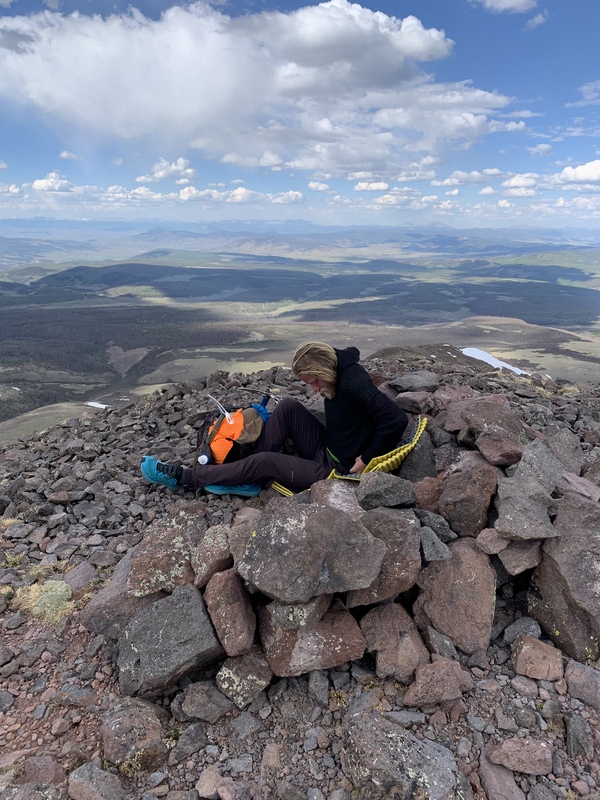
We didn’t spend too much time on the summit after signing the register because we still had one climb to go to make it to our proposed campsite for the evening in the Stewart Creek Valley. We deviated slightly from our ascent route up Stewart to trend southwest into the basin between it and Baldy Alto, again, not encountering any terrain beyond class 2. We soaked our shoes and socks in the marshy spring runoff streams once more and finally began our last ascent up Baldy Alto’s northwest slopes. We were able to manage to not repeat Baldy Alto’s summit and instead popped up and over the peak’s northeast ridge before dropping over the other side, where we used our ice axes for the first time on the trip (I was happy we hadn’t carried them all this way for nothing). 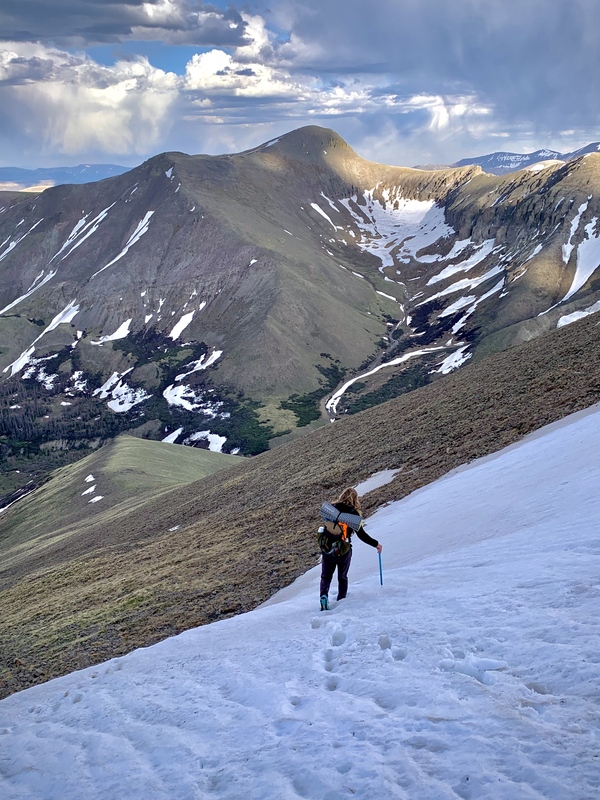
From there, the descent to Stewart Creek was steep and we took care not to turn an ankle on the many lumpy grass mounds. We stopped at the creek to get water for the night and found a perfect campsite just off the standard San Luis trail. It had been a big day, almost 13 miles and over 6,300’ of climbing, but the stunning, relatively easy peaks made this quite the enjoyable adventure. Day 4 – June 13, 2024 13.65 miles; 7041’ elevation gain Peaks summited:
Upon waking up in our pleasant, flat campsite, I was aware we still had to cross Stewart Creek to gain Organ Mountain’s ridge, and I was worried a cold ford through swift moving water would be necessary. As we made our final descent down to the river from our site, Garrett spied a snow bridge right where we were hoping to cross. Given that it was mid-June and temps had been relatively warm, I was nervous to cross and made him go first, which he graciously did. 
He crossed over easily on the hard, early morning snow (though still minding his step), and I hesitantly followed in suit. Luckily the bridge held, and from there we were on our way to Organ’s summit. Organ’s ascent was steep, class 2 grass which was best completed by putting one’s head down and grinding out the vert. We didn’t stay quite ridge proper, which would’ve added some unnecessary elevation gain, and instead side-hilled across the peak’s northeast slopes before arriving at the final talus pitch to the summit around 13,600’. 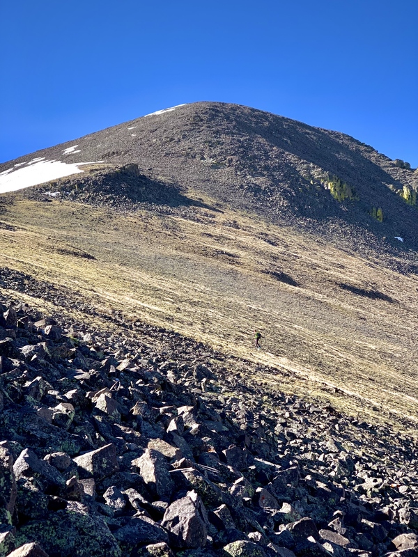
We summited around 9 a.m. and then began to pick our way down the peak’s south slopes, admiring the impressive pipes that composed Organ’s southwest flank. We descended steep class 2 grass slopes until we ran into a set of rugged cliff bands at around 12,300’ in elevation. It appeared all of the steep terrain cliffed out from here, so Garrett suggested we head west until we found a break in the cliffs and could continue down to the Colorado Trail. If you take the route Gerry Roach describes in the 13ers guidebook, all of this can be avoided. However, because we didn’t ascend this route before trying to pick our way down, our descent line was suboptimal. 
Our path down from here was more ankle-turning, steep grass that ultimately led us through some deadfall before delivering us onto the Colorado Trail. It was slow going for me, especially with my backpacking pack, and Garrett, who was moving much more efficiently over this terrain, offered to carry my pack for me along with his own by wearing my pack on his front like a big pot belly. You don’t get a great deal like that too often, so I took him up on it, and tried to pick a path of least resistance through the remaining talus and deadfall toward the Colorado Trail. When we finally made it down to the CT, I was thrilled. Easy, class 1 walking was just what I needed after some slow off-trail miles! We took the trail to San Luis Pass and then re-ascended UN 13,166’s north class 2 ridge. We had chosen this route because based on our map, it looked like the most efficient option would be to follow the peak’s SW ridge over to our next proposed summit, UN 13,179. Garrett reascended 13,166’s class 3 crux just for fun when we arrived, and we then wrapped around the mountain’s NW flanks to our intended ridge. Unfortunately, we ran into a bit of a snafu here. The ridge, though mellow in almost its entirety, presented a narrow, crumbly stretch of rock spires less than a quarter mile from UN 13,166’s summit. Before Garrett had even had the chance to fully assess the route and see if an easy traverse over the difficult-looking terrain was possible, I had already opted out. 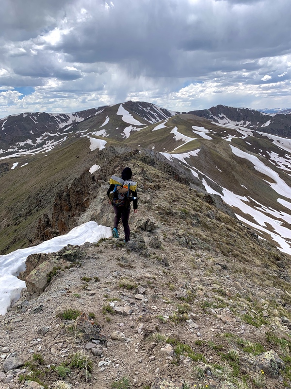
Whether or not the route was difficult in reality, I experienced vertigo and anxiety just looking at it. I was fatigued from the weight of my pack, the jagged rock spires scared me, and it looked like a long tumble to the valley floor below if I mis-stepped. I was nearly suffocated by fear before I relayed my sentiments to Garrett, who patiently listened and kindly suggested that we retrace our steps to San Luis Pass, hop on the Colorado Trail for about half a mile, and then ascend the ridge we were hoping to gain via a well-established game trail, bypassing any difficulties. Relieved and embarrassed at my lack of courage, I agreed, and we did just that. It actually may have been quicker to pursue this route option to begin with rather than complete the elevation and distance required to gain this ridge from UN 13,166, but it’s impossible to say for certain. We had burned about an hour and a half of time on this detour, and I was kicking myself for not being braver and figuring out how to navigate the tricky ridge section. Regardless, we were headed a different way at that point and it wasn’t long before we were back on our proposed route. The remainder of the ridge toward UN 13,179 was easy class 2 grass and talus that dropped us right on the summit around 4:15 p.m. Or, at least, a summit. “Is that a cairn on that rock feature over there?” I asked Garrett while pointing to a small outcropping about 100 yards away. All of a sudden, I wasn’t sure if we stood on the true summit or if we still had a bit of class 2+ scrambling left to go due to the new-ish Lidar peak rankings. To be sure that we weren’t inadvertently orphaning a summit that was easily within reach, we made our way to the mildly spicy, class 2+ summit cap before retracing our steps to the initial summit. 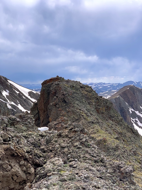
Upon arriving on the initial summit again, we found an empty summit register jar leading us to believe this was, in fact, the true summit. Regardless, the other summit was a fun little challenge and I was happy to have tagged both, just in case. Our next intended summit for the day, UN 13,308, was just a short ridge scramble away from where we stood. However, the route looked absolutely atrocious. Gerry Roach noted that 13,308 could be attained from 13,179 by this ridge via some, “nifty class 3 moves,” but the route had some lingering snow, and I wasn’t mentally in a place to attempt this route, so we decided to bite the bullet and take the long way to 13,308’s summit. From the saddle that connected 13,179 with its sub-summit to the northeast, we found a loose, class 2 game trail that led, at least partially, to the valley floor below. We took it for as long as we could before navigating to a wide snowfield and shoe-skiing down after a few posthole-y first steps. We repeated the process between loose class 2 scree and snowfields before finally arriving at the Colorado Trail again around mile 8.5 for the day. 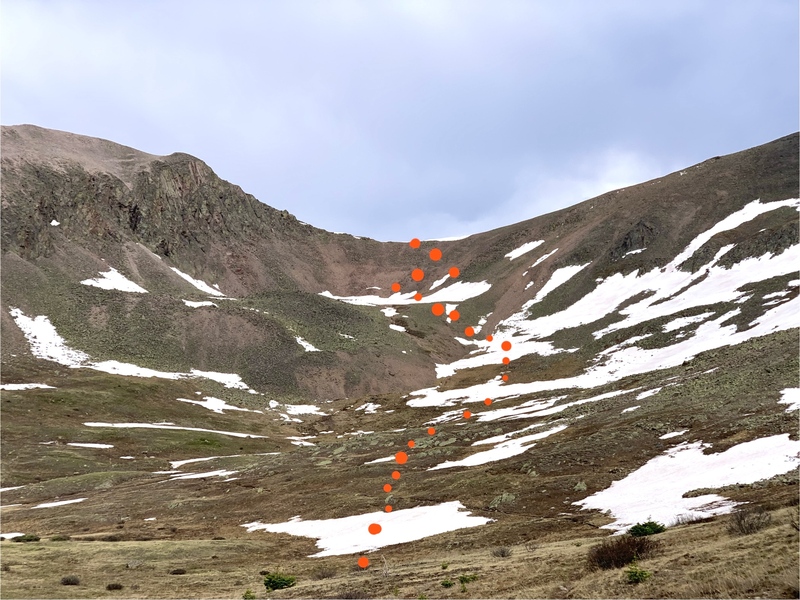
We followed the CT for about 1.5 miles before turning left and gaining 13,308’s long, NW summit ridge. This summit ridge was mostly class 2 grass, but changed to talus blocks around a mile in. The route was straightforward and didn’t leave much room for creativity (we just followed the ridge). The slabby, gnarly cliffs of igneous rock that that composed the peak’s ridge couldn’t have looked more different from the gentle, easy terrain that made up the peak’s slopes on the opposite side, and I was grateful we had taken the easy option to gain this summit, even though it had been far less direct. The stark contrast between the peak’s aspects were inspiring, especially as the evening sun began to set. 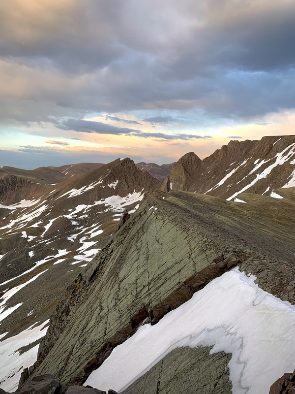
When we arrived on the final summit ridge, there appeared to be a few high points that could have been the summit, but we ultimately found the highest by maintaining the furthest north edge of the ridge. We quickly signed the register and because it was nearly 8 p.m. at this point and we didn’t want to camp on the high ridgeline, we hustled back down the mountain’s gentle slopes, while appreciating the sunset that illuminated the surrounding peaks. 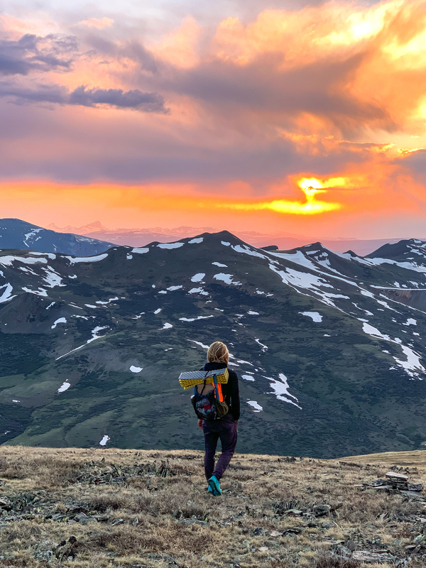
We made it nearly back to where we had deviated from the Colorado Trail – just where we wanted to be to set ourselves up for tomorrow’s peaks. We had clocked 13.65 miles and just over 7,000’ of climbing for the day, making it the biggest day (elevation gain) we would experience on our trip. Day 5 – June 14, 2024 Katie – 13.74 miles; 4000’ (approx.) elevation gain Garrett – 16.69 miles; 6053’ elevation gain Peaks summited:

The next morning was cloudy and gray. We had slept without a tent again the previous night, and at one point I was woken up by flecks of rain sprinkling on my face (Garrett had slept right through this and had no recollection of rainfall when we awoke in the morning). He insisted that these morning clouds would burn off and we’d have a great day of sunny hiking to look forward to, but I wasn’t so sure. We made our way back to the Colorado Trail, the most efficient route toward our next summit, UN 13,115. My weather worries were confirmed when we bumped into some CDT hikers who asked if we had heard about the lightning forecast for the day. They said it would arrive by either 9 or 11am, and since it was already around 7:30, I wasn’t sure how much time we’d have to safely remain above treeline. The route to the summit of UN 13,115 was straightforward, class 2 tundra walking. We continued on the CT for as long as we could then, once the trail started heading downhill to a nearby saddle, we trended westward, uphill to the summit. Once there, we wasted almost no time descending to the saddle on the north side. As we did, the sun became obscured by heavy cloud cover and the weather continued to look increasingly threatening. 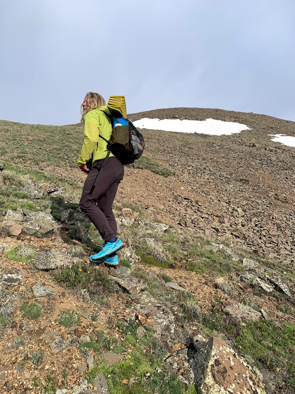
We were able to follow some faint game trails north toward UN 13,005, our next summit, over grassy terrain until we reached a small, class 2 headwall that led to yet another grassy class 2 summit ridge. We had just begun making our way up 13,005’s final summit ridge when I told Garrett I no longer felt comfortable at our current elevation given my lack of ability to move efficiently over off-trail, alpine terrain in the stormy weather. As disappointed as I was to not continue on to our next summit goals, I wasn’t about to risk getting caught in a storm up high if I could avoid it. Garrett patiently accepted my withdrawal from our mission, and we decided together that it would be in our best interest for me to turn back, make my way to the Colorado Trail and pitch our tent to take shelter from the impending storm, while he forged on as quickly as possible to tag the two summits that lay ahead, UN 13,005 and Baldy Lejos. I was frustrated to abandon two more easy peaks in the La Garitas, but ultimately I knew it was going to be time-consuming and inefficient for me to tag them along with Garrett, and I wanted him to have the chance to summit. We parted ways, with me retracing my steps to the south, and Garrett forging on to the north. Not ten minutes after I started making my way back, a squall blew in and delivered rain, sleet, strong winds, and even some snow. I was freezing in my shorts and light rain jacket, and I was worried for Garrett who was continuing to higher elevations, but I trusted him enough to know he’d turn back if conditions got too heinous up high. After hustling my way down the CT for about a mile and a half, I pitched the tent in an easy-to-see location not far from the trail and crawled inside, soaking wet. Garrett arrived at camp about 30 minutes later, exhilarated from racing a storm on his most recent two summits and encountering an enormous elk herd at close range. He recounted the details of the ascents to me, and they sounded, by and large, quite easy. I was bummed to have missed out but knew that if I had tagged along it would’ve taken us significantly more time and kept us above treeline for more time than I would’ve been comfortable with, given the weather. As the rain poured down, we huddled in the tent, tried to dry out our gear and clothes, and then took a nap since we were feeling a bit fatigued from the week’s mileage up until that point and had nothing better to do while we waited out the storms. When we awoke about an hour later, the sun had started to tentatively peek through the clouds and it was time to make a call about how we wanted to proceed. The forecast for the rest of the day looked questionable, so I decided, begrudgingly, that it might be better for Garrett to pursue the class 2+/3 north ridge to gain UN 13,030’s summit solo while I wrapped around the peak on the CT to a saddle that we had mutually agreed to meet at. I was bummed to abandon yet another La Garita 13er, but I also didn’t want to slow Garrett down and hinder his likelihood of completing all the summits in the range on this trip like we had intended. He agreed to give me the tent and a couple other non-necessities so he could reduce his pack weight and move more quickly since I’d just be doing easy hiking on the Colorado Trail. We then we parted ways, once again, with a plan to meet as soon as possible. 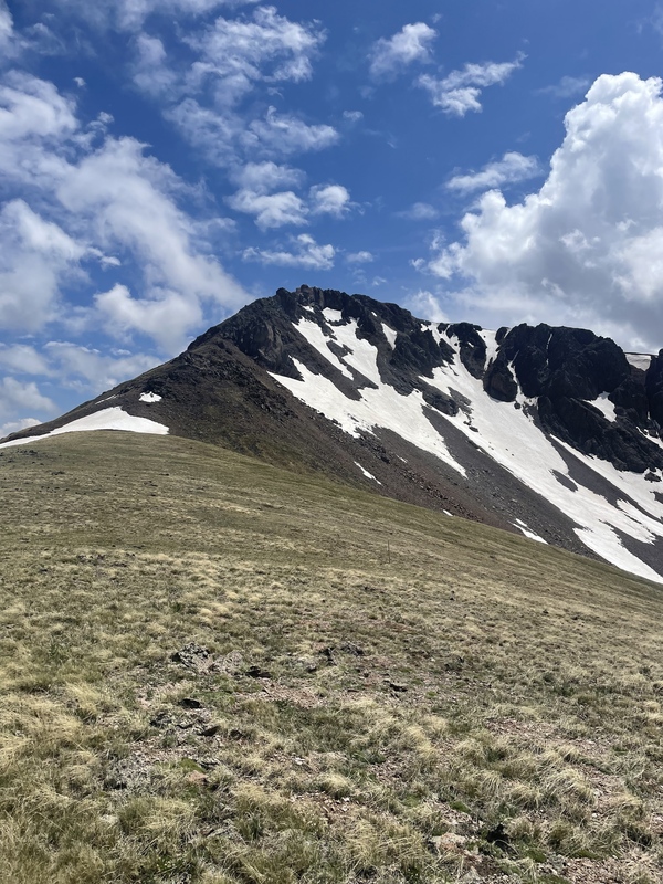
I enjoyed some easy, sunny miles on the CT, drinking in the pretty San Juan views and reminiscing on the time we had spent thruhiking the trail in 2021 and then again in 2023. The clouds grew progressively darker as I hiked, and by the time I arrived at the steep, snow-filled gullies that necessitated use of an ice axe about three miles down the trail, I was hurrying along, hoping I didn’t start to hear any thunder in the distance. I did, unfortunately, but it wasn’t until I had almost nearly arrived on the saddle where we had agreed to meet, and I saw Garrett wave to me in the distance. It was an easy decision to not carry on from here given the quickly approaching storm, so we pitched our tent in the willows, tossed our ice axes a moderate distance away to ensure they wouldn’t act as lightning rods (not that it would’ve made a huge difference since we were sitting inside a tent held up by metal poles above treeline) and climbed inside just as rain and hail began to pour down. The hail piled up around the tent in small mounds, and it was obvious we had made the right choice. The storm, despite its ferocity, was short lived and cleared out of the area after about 30 minutes. The sun reappeared in the sky amidst low-hanging clouds and we decided that, since we had limited time tomorrow before Garrett had to clock in for his afternoon shift at work the following day, it might make sense for us to tag a couple summits in the early evening that day. I had already completed the Baldy Cinco group in 2021 and didn’t care to re-summit any of these peaks, but I did, however, want to tag UN 13,030 since I hadn’t earlier in the day and really didn’t want to orphan it if I didn’t have to. Garrett was hoping to knock out UN 13,030 (yes, there’s another unofficial summit also named UN 13,030), as well as UN 13,505, leaving him with just three remaining summits to tag the following morning if he was successful in attaining these two summits. We took off, once again, in different directions, intent on summiting our respective peaks. The route to UN 13,030 East was straightforward from the saddle where we had pitched our tent. I hiked up class 2 grassy tundra toward the summit of a nearby, unnamed 12er before dropping into the small basin on the other side. From there, it was easy to stick to the northwest ridge, marked obviously by steep cliffs, and grind to the summit a short distance away. It ended up being about 2.5 miles from where we had camped, all mellow, unremarkable (but quite pretty) San Juan tundra. 
I signed the summit register upon my arrival, gave my parents, whom I hadn’t spoken to in a few days a quick call to let them know where I was at in the world, and began working my way back to camp. This was my last summit of the trip, and this pretty, solo hike at golden hour felt like a fitting way to conclude my time in the La Garitas. Instead of following my approach route and sticking to the ridge, I opted to hike through the basin so I could fill my water bottles since we weren’t camped near any water sources. It was easy to find a refill source given all the spring runoff, and not two hours after I began my hike, I was back at camp with Garrett who had arrived at almost the exact same time, having successfully summited UN 13,030 West and UN 13,505. 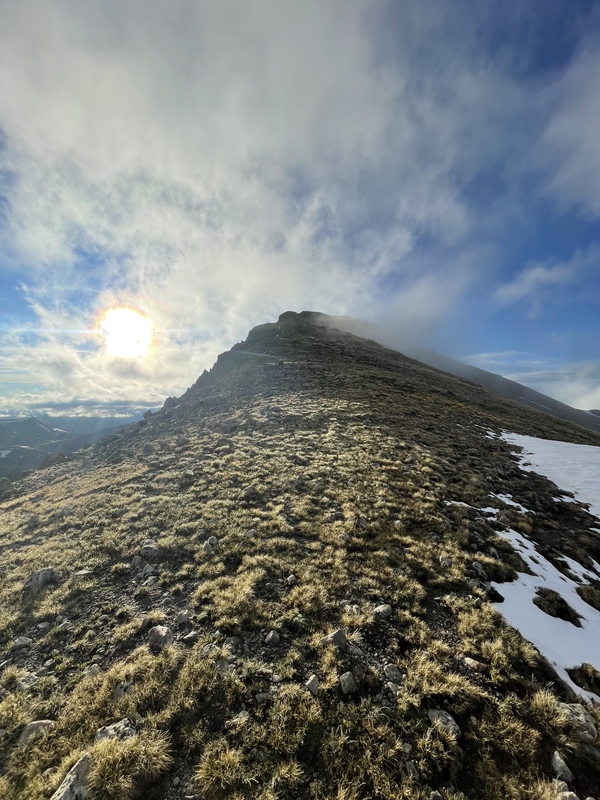
The sunset painted the sky a vibrant orange while an elk herd watched us curiously from the distance. After some chatting, we decided that the most important goal for our final day on trail was to make it back to the cars in time to stop at W Café in Gunnison on our drive back to Crested Butte. In order to make that happen, I was going to forgo summiting the final three peaks of the trip (which I had already done previously) while taking the majority of our backpacking gear so Garrett could hike quickly and tag these summits. Day 6 – June 15, 2024 Katie – 8.28 miles; 815’ elevation gain Garrett – 8.54 miles; 2241’ elevation gain Peaks summited (all Garrett)
We were jolted awake by our alarms, as planned, at 4:30am the following morning. I urged Garrett to hurry on and leave breaking down camp to me so he could summit his final few peaks quickly. After all, the only hiking I had left for this trip was a few glorious, gorgeous miles on Snow Mesa, one of my very favorite sections of the Colorado Trail, which I anticipated wouldn’t take long. He packed up his pack, insisted that I hang onto our sole headlamp so it’d be easier to break down camp, and headed off in pursuit of UN 13,168 to the west. I leisurely deconstructed our tent, arranged my pack for the day, and at 5:00 a.m. on the dot, I began my final eight-mile deproach on Snow Mesa. The trail was largely, though not entirely devoid of snow, and the pretty sunrise colors made the surrounding skyline pink as I hiked my way to Snow Mesa’s flat expanse. 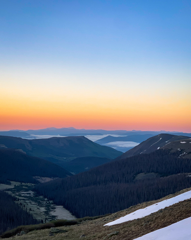
I hiked efficiently, averaging almost 3 mph and arrived at Spring Creek Pass to Garrett’s 2000 Honda Accord. He arrived about 20 minutes later, having made excellent time summiting his final three peaks of the trip – UN 13,168, Baldy Cinco, and Baldy no es Cinco. He said the summits were all very easy, grassy tundra peaks, with the exception of a class 2+/3 bluff he ascended after leaving the Colorado Trail to attain UN 13,168’s summit. 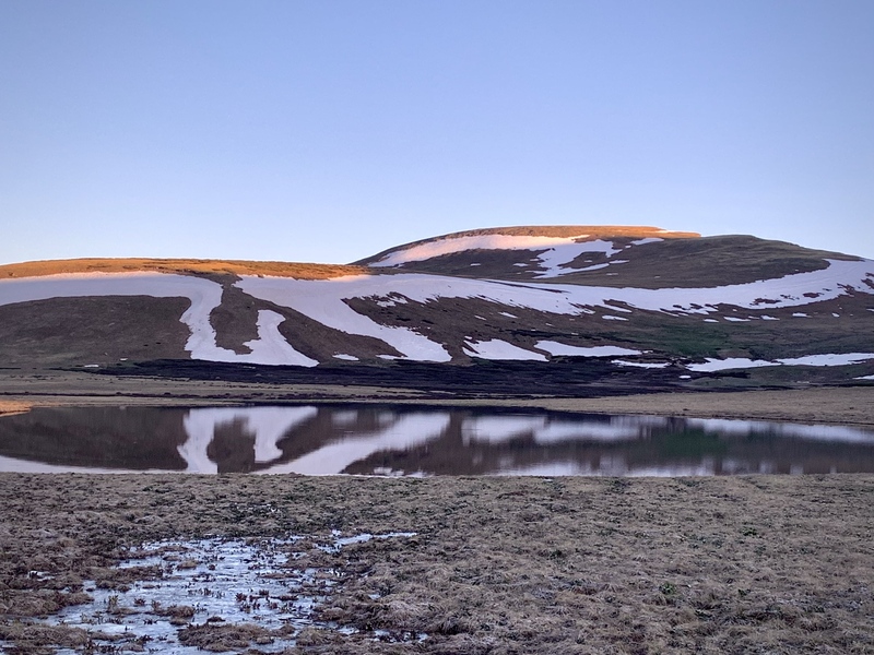
I checked my watch upon his arrival; we’d have just enough time to make it to W Café! Our early start had been worth it. From Spring Creek Pass, we drove back to the Wheeler Geologic Area trailhead to retrieve my car, admiring the Phoenix Peak skyline on the commute and debriefing our adventure. Garrett had successfully knocked out every summit in the range, and between this most recent trip and one I had taken in August 2021, I only had three summits in the range remaining. Spending a week in the La Garitas was an ideal way to tackle these remote peaks, some of which can be difficult to do as a day trip (I’m looking at you, Baldy Lejos; I’ll be back for you and it’s going to be a long day to make it happen). None of these peaks, with the exception of UN 13,166, were technically difficult, and linking the range’s mostly mellow ridgelines helped us feel like we really got to know the area. What a treat it was to immerse ourselves in this vast wilderness and stand atop summits we had long admired from our previous travels on the Colorado Trail! I (almost) wish there were more peaks in that range so we’d have an excuse to return for more. 
Thumbnails for uploaded photos (click to open slideshow):  Our packs for the week")
 Garrett hiking toward Wheeler Geologic area")
 Garrett heading down the snow after Halfmoon Pass. Storms were approaching quickly from the west.")
 Our campsite with some 12ers in the background. For anyone curious, our tent is a Nemo Hornet 2p. Great little tent, but be prep")
 Heading up one of La Garita Peak’s east ridges. This was about 500 vertical feet of climbing.")
 Ascending a snowfield after the class 2, talus block ridge from La Garita Peak’s sub-summit (left). We stayed mostly ridge-prope")
 Garrett on the summit of La Garita Peak")
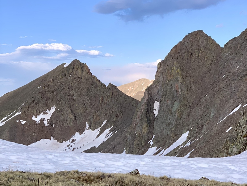
 Heading toward Phoenix. Machin Lake can be seen to the right.")
 Garrett next to Phoenix’s enormous summit cairn. We’d be able to point this out from many of the surrounding peaks we’d climb in")
 Looking toward UN 13,408. Much of the route is visible besides the talus ridge we descended to gain the summit from the southwes")
 Getting down the talus ridge between Phoenix and UN 13,408.")
 Ridgeline carnage. 13,408’s summit can be seen to the right.")
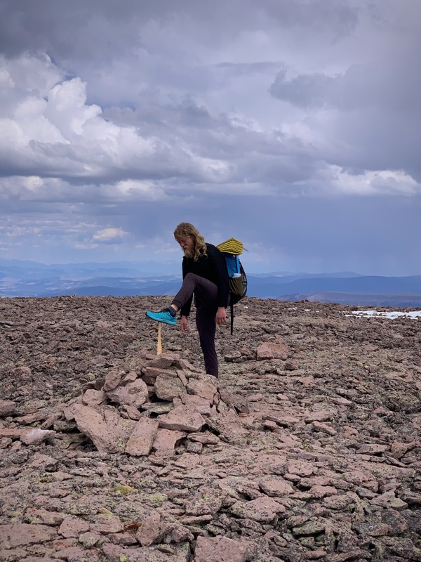
 Garrett on UN 13,408’s flat summit. Gotta touch the tippy-top or it doesn’t count!")
 Deadfall obstacle course")
 Our avy gully ascent up UN 13,026. Steep, but direct.")
 Garrett nearing the summit of UN 13,026. Easy, but tiring terrain after a big day.")
 Heading downhill to camp on the large flat saddle pictured to the left.")
 The final ridge to 13,166’s summit was easy tundra walking. The exposed, class 3 summit cap is seen in the center of the image.")
 Headed toward San Luis (center) from UN 13,166. The saddle low point is San Luis Pass.")
 Garrett’s route to UN 13,166’s summit. The exposure is not evident from this photo and the true summit isn’t quite visible.")
 Looking ahead toward some of our remaining peaks for the day.")
 Our route off San Luis on a game trail, indicated by the red arrow. We had lots of options to choose from, and all were in excel")
 Garrett making a few final moves to the summit.")
 Looking back on our route up Baldy Alto. We stayed as ridge proper as we could for the most part.")
 Garrett on the final, easy summit section of Column Ridge.")
 Looking ahead toward Baldy Chato. It looked SO far (and indeed it was. About two miles away, one way, from Column Ridge).")
 Garrett admiring Baldy Chato’s rotten and impressive cliffs and gullies.")
 Signing Stewart’s summit register.")
 Making our way down a snowfield that got steep toward the bottom and looking ahead toward Organ.")
 The first part of our route for the morning. The snowbridge we used to cross Stewart Creek is circled in red.")
 Almost at the summit of Organ. Garrett (smartly) opted to hike on easy grass. I opted to hike on loose, avoidable talus, which w")
 A look back at the tricky terrain we opted not to try to navigate. We turned west in search of easier terrain at the high point")
 Garrett heading toward the difficult ridge which isn’t pictured well here. I wish I had gotten better photos of this tricky spot")
 Is that cairned high point the summit? Or is the point I’m standing on with an empty jar hidden in a rock cairn the summit? We t")
 A look at our route down to the Colorado Trail, indicated by red dots. An alternate, less direct route option here would have be")
 A closer look at the 13,179 to 13,308 traverse. This isn’t a great depiction since you can’t see most of the true route, but it")
 Ridge views en route to 13,308. The traverse from 13,179 to 13,308 is pictured in the center of this image.")
 San Juan sunset skies on our descent to camp.")
 Garrett hiking to the summit of 13,115 which you can see in the back. Here, I was holding out hope that our mix of clouds and su")
")
 Garrett’s misty mountain hike headed toward a summit")
 Sunrise pastels above the mountains and hillsides near Creede.")
")
")
")
")
")
")
")
")
|
| Comments or Questions | ||||||||||||||||||
|---|---|---|---|---|---|---|---|---|---|---|---|---|---|---|---|---|---|---|
|
Caution: The information contained in this report may not be accurate and should not be the only resource used in preparation for your climb. Failure to have the necessary experience, physical conditioning, supplies or equipment can result in injury or death. 14ers.com and the author(s) of this report provide no warranties, either express or implied, that the information provided is accurate or reliable. By using the information provided, you agree to indemnify and hold harmless 14ers.com and the report author(s) with respect to any claims and demands against them, including any attorney fees and expenses. Please read the 14ers.com Safety and Disclaimer pages for more information.
Please respect private property: 14ers.com supports the rights of private landowners to determine how and by whom their land will be used. In Colorado, it is your responsibility to determine if land is private and to obtain the appropriate permission before entering the property.