Download Agreement, Release, and Acknowledgement of Risk:
You (the person requesting this file download) fully understand mountain climbing ("Activity") involves risks and dangers of serious bodily injury, including permanent disability, paralysis, and death ("Risks") and you fully accept and assume all such risks and all responsibility for losses, costs, and damages you incur as a result of your participation in this Activity.
You acknowledge that information in the file you have chosen to download may not be accurate and may contain errors. You agree to assume all risks when using this information and agree to release and discharge 14ers.com, 14ers Inc. and the author(s) of such information (collectively, the "Released Parties").
You hereby discharge the Released Parties from all damages, actions, claims and liabilities of any nature, specifically including, but not limited to, damages, actions, claims and liabilities arising from or related to the negligence of the Released Parties. You further agree to indemnify, hold harmless and defend 14ers.com, 14ers Inc. and each of the other Released Parties from and against any loss, damage, liability and expense, including costs and attorney fees, incurred by 14ers.com, 14ers Inc. or any of the other Released Parties as a result of you using information provided on the 14ers.com or 14ers Inc. websites.
You have read this agreement, fully understand its terms and intend it to be a complete and unconditional release of all liability to the greatest extent allowed by law and agree that if any portion of this agreement is held to be invalid the balance, notwithstanding, shall continue in full force and effect.
By clicking "OK" you agree to these terms. If you DO NOT agree, click "Cancel"...
My friend and I always seem to choose difficult peaks when we hike together (The last one being Maroon Peak) and this day was no different. I have been looking at the Wetterhorn - Uncompahgre loop for quite some time and it was one that had always captured my interest and sense of self challenge. It is not a grouping that is typically done, at least as commonly as other 14er duos such as (Greys/Torreys, Shavano/Tabeguache, Oxford/Belford) etc. It is one that most people talk about as "too long of a day" or "too far apart". In fact, this website does not even list the combo route. I find that disappointing as I know many of the users on here are curious about this combo or have done it themselves. You must go to Roach's book to consult the matter. For this reason I have decided to write this report and make comments on what I think may be important to consider when doing this loop.
Route Information:
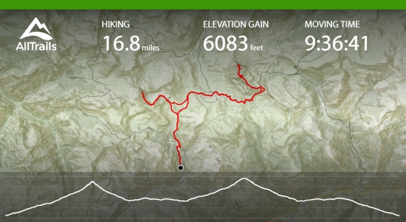
We started and finished at the Matterhorn Creek Trailhead. We hiked Wetterhorn first then Uncompahgre. Total mileage was 16.8 miles via the All Trails app we used to track our hike. Total hiking time was 11 hours including time on summits (9.5 hours moving time). We started at 4:19 AM and were on the summit of Wetterhorn at 7:08 AM. We reached the summit of Uncompahgre at 12:04 PM and were back at the trailhead by approx. 3:30 PM. Below are some pictures of our stats from the app.
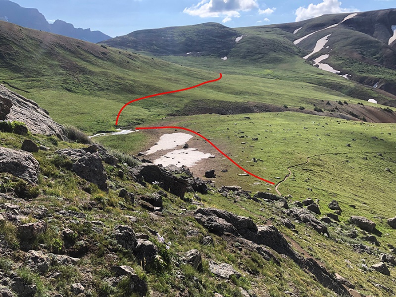
Summary of the route. You can see how we cut across the tundra after leaving Wetterhorn on the way over to Uncompahgre.Interesting look at pace per mile and elevation gain along the way.
Beginning:
We started by leaving Denver the night before and stopped to grab dinner in Lake City before we drove the 11 miles up Engineer Pass to the TH. We camped below the 4WD road which I would definitely recommend as camping at the TH would be more exposed to weather and not the greatest. We found a good camping spot next to the creek about a quarter of a mile before the 4WD turnoff marked for the Matterhorn Creek TH. When we arrived at camp we noticed we were losing tire pressure in one of the rear tires so we started the trip off by changing the tire. Luckily we had given ourselves plenty of time and were able to change the tire and set up camp before it got dark and started to rain. After the tire was changed we set up camp and got some rest. We woke up at 3:00 AM, finished packing our gear and ate breakfast, leaving our tents to pack up later and drove up the 4WD road to the TH. We started hiking by 4:19 AM.
Wetterhorn:
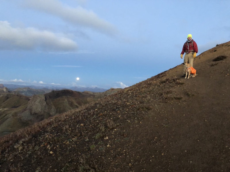
By far the most fun we had was during the approach and summit of Wetterhorn. We left the TH in good spirits and started our ascent up through the trees into the valley surrounded by the stars. It was a clear night and afforded us with a full moon and stars to guide our way. We used headlights for the first part but ended up turning them off in the valley as there was enough light to hike without them and it was more enjoyable to do so. We hiked until we saw the turnoff between Wetterhorn Peak and the Ridge Stock Driveway Trail #233. This is an important junction as it is a point you will inevitably reach towards the end of the day but will not see again until then if you do the loop the way we did. Since we were hiking Wetterhon first we turned to the left and continued our ascent of Wetterhorn. A note here, after we downclimbed Wetterhorn we did not return to this point but instead cut across a half mile higher as can be seen in the map above. We believe this saved us significant time and also from losing a decent amount of elevation. The trek across the tundra was much easier than the portion of Ridge Stock trail you would have to hike if you hiked all the way back to the junction before turning towards Uncompahgre. After the junction we continued upwards passing a small boulder field and reaching the saddle of Wetterhorn. The moon was out and we enjoyed a minute before continuing.
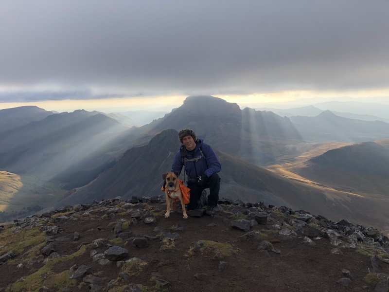
WetterhornPhoto of my friend and his dog on the saddle.
As can be seen in the photo above, we were hiking with a dog. It was a requirement if I wanted my friend to come with me. I was nervous about the top of Wetterhorn as I had researched the class 3 scrambling required. I had informed my friend of this and we made the decision that if needed, one of us would wait with the dog and take turns summiting. As it turned out Finn (the dog) was very adept in climbing and didn't have any problems going up. On the way down there were a few spots that he needed help on and we made sure to keep him between us and lifted him past the few parts he needed help. He had on a doggy pack with a handle on the top that greatly assisted in lifting him when needed. Finn did great and was a stud the whole trip. However, I would not recommend Wetterhorn for most dogs and it was a big concern of mine coming in. A bigger dog would have had more problems than Finn as it would be harder to help him on the way down.
A shot of descending the steep part of Wetterhorn with Finn. It is slightly steeper in the picture than in reality. We were above and below Finn to help him.
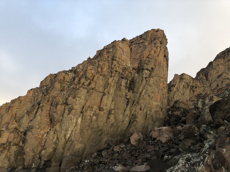
After the saddle we continued up until we reached the prow which is an impressive rock structure and worthy of a photo.
The Prow.
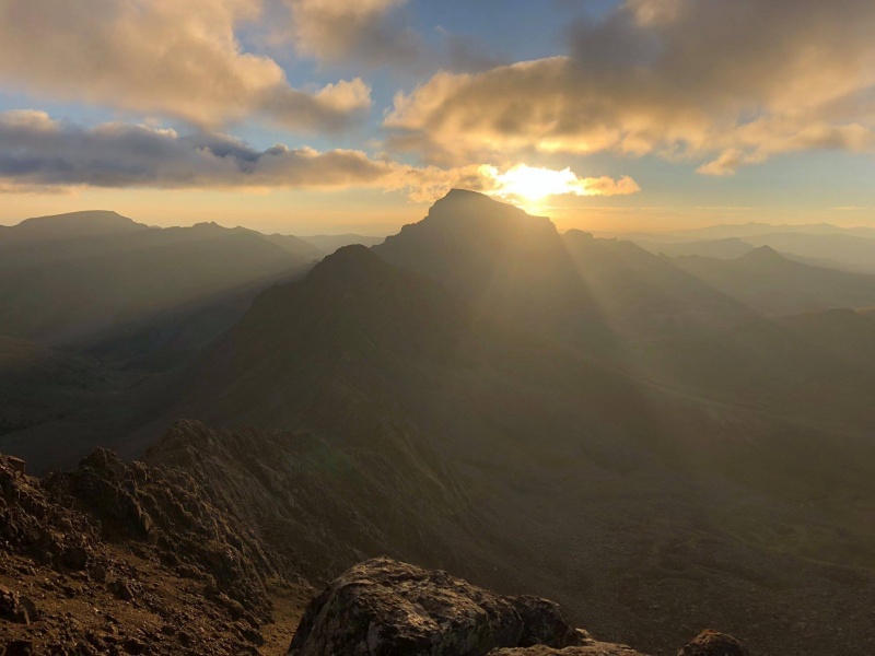
We continued upwards and were rewarded with some excellent shots of the sunrise coming over Uncompahgre as well as the alpenglow across the valley.
Sunrise over Uncompahgre as seen from WetterhornAlpenglow during sunrise.
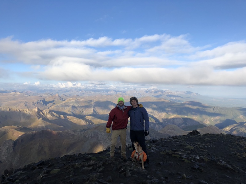
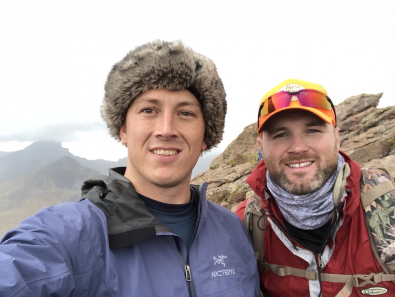
Shortly after we summited at around 7:05 AM with a TH to summit time of ~ 2:45.
Jason and I on Wetterhorn's summit.Wetterhorn summit with Uncompahgre in the background covered in clouds.
At this point we felt great and were confident. We had a strong pace so far and even though Uncompahgre was a long ways off in the distance, we were in high spirits.
Trek Over to Uncompahgre:
From the summit of Wetterhorn we downclimbed past the boulder field and ended up cutting across a gully and trekking across the tundra until we met up with the Ridge Stock Driveway. The best way to describe where we cut across is when coming off Wetterhorn and approaching Matterhorn, there is a gully between them with a creek running through it. We crossed this creek before the gully got deeper with bigger walls on each side. This was roughly half a mile above the lower trail junction that I mentioned earlier. I do not have a picture of this part unfortunately but I would definitely recommend it as it saved us time and elevation and was overall much more enjoyable. After connecting with the Ridge Stock Driveway Trail #233, we followed this through the valley across the saddle with Matterhorn and all the way until we were below Uncompahgre.
One thing to note here is that there is a turnoff for Trail 228. Do not take this. Stay on the Ridge Stock Driveway until you wrap completely around all the cliffs and move up the saddle until you join the main route. There is an option to take a shortcut and go up a gully on the west side. This will save you 4-5 miles but from all accounts is a bear and filled with unpleasant scree/sliding and is very steep. We elected to take the trail around and I think this is the correct choice for most. I love higher class hiking and a good class 3,4 or even low 5 section. I do not think the west gully would provide this "fun factor". You may cut miles but it just looks unnecessary and more pain than it's worth. This is my opinion so take it for that.
After wrapping around the cliffs we ascended to the 1st saddle and found a very random yet very cool feature that someone had built on the side of the mountain...a "chair".
Jason and Finn took full advantage and grabbed a good shot here with Wetterhorn (left) and Matterhorn (right) in the background. This was a good place to stop for a break and some food.
Uncompahgre:
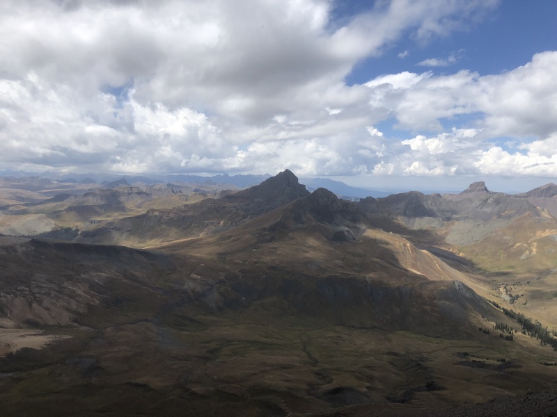
From this point we continued our ascent of Uncompahgre. The hike from here is very straight forward. We met up with the main trail at the second saddle and climbed toward the peak.
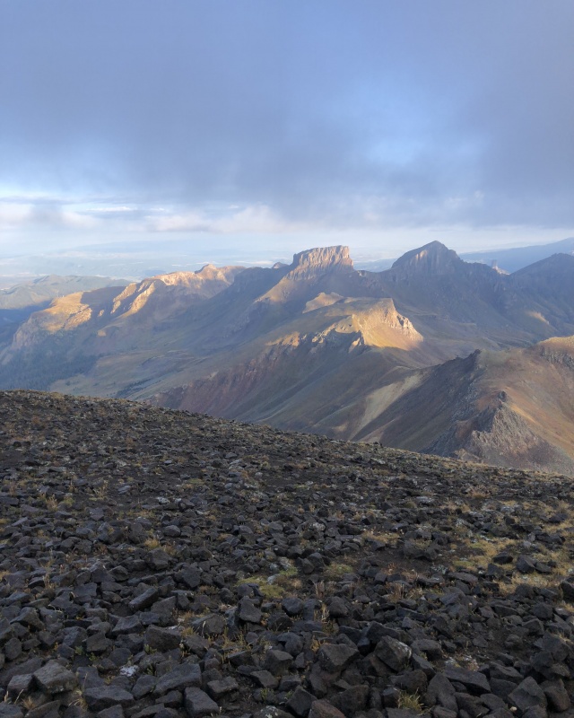
Uncompahgre from just above the saddle where the 2 trails meet.
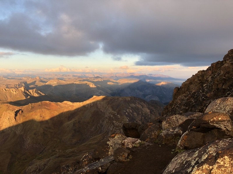
From the point where the above picture was taken it took us ~45 minutes to reach the summit. This picture is important because you can see the relatively blue sky.
As we reached the summit we noticed clouds coming in from the west but they were not on top of us yet, it was not raining and we figured we had time for a quick summit and descent off the mountain. At this time it was 12:05 PM.
Uncompahgre SummitView from the summit of UncompahgreWetterhorn as seen from the Uncompahgre summit.
We quickly realized that the clouds were moving in much faster than we had anticipated. We had not even had time to eat a sandwhich when things went south. We were discussing the clouds and decided to get off the summit asap. Below is a good picture of what things looked like at this point.
Uncompahgre summit minutes before the lightning strike.
The above photo was taken about 2 minutes before a lightning strike cracked the sky open and came down about ~200 ft away from us on the summit. I happened to be looking in the direction of the strike when it happened and it was the most visceral, awe inspiring / terrifying thing I have ever seen from nature. The loud crack of thunder and the flash of light from the bolt were immediate and truly incredible. I have been on quite a few summits, many with cloud cover and have been fortunate enough never to witness anything like this before. Jason and I had a similar experience on Antero (minus the lightning) where we felt static electricity buildup and scrambled off that one as fast as possible. We were also on top of Holy Cross in the middle of the clouds on a nice day. This however, was different. This cloud rolled in fast and hard with little warning, no rain, only hail about a minute before the lightning and was gone just as fast. After the lightning strike we ran for what felt like our lives. The fortunate and unfortunate thing about Uncompahgre is that it is a very, very large summit. The fortunate part of this for us was that because the summit was so large, the lightning had a large area to choose from and by some miracle hit 200 ft away from us. This is in contrast to the lightning strike hitting right on top of us, which it likely would have done, if it would have been a small summit. The unfortunate part came in that after the strike, we had quite a distance to run to get off of the summit and as far down the side of the peak as possible. This sprint in the seconds immediately following the strike was surreal. It felt like our lives were not ours and that at any time a bolt was going to come from the sky and there was absolutely nothing we could do about it. It was a feeling of helplessness that is hard to describe. Imagine having no control over your muscles while someone lifts a gun and points it at your forehead. This is what being on that summit after the lightning strike felt like to me.
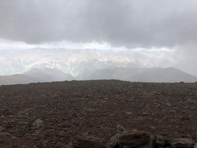
We made it off the summit and scrambled down a few hundred feet. At this point no additional strikes or thunder had taken place and the sky had changed quite drastically.
View of the sky 5 minutes after the lightning strike.
As you can see in the above picture, clear skies reigned once again. This was quite the contrast to a few minutes ago and shows the speed at which the clouds were moving this day. One minute clear, the next a thunderstorm and then clear once again. I want to make this point clear as I know many will take the opinion that if you get caught on the summit during a lightning storm, it is your own fault and you should never risk your life for a summit. I wholeheartedly agree with this but will maintain that with the lack of hearing thunder, not seeing rain and to the speed at which the clouds were moving, it was difficult to predict what would happen. We hiked for over 11 hours that day and the only thunder/lightning that occurred was during the 15 minutes we were on the summit of Uncompahgre.
To make this report useful I think the takeaway from this would be to study the clouds and their movement more closely. If we would have realized the speed at which the clouds were moving, we could have hunkered down below the summit and waited for them to pass. Instead we misjudged them and it almost cost us our lives. The sky was clear before and clear after, throughout the entirety of the day. That one cloud and that one bolt of lightning could have been all that it took to make things deadly.
The Long Trek Back:
After our close call we continued down the mountain. We met another group ascending just above the saddle where the trails meet and gave them a cautionary warning of our experience. We advised them not to summit if they saw any clouds in the distance that looked ominous and pointed out the speed at which the clouds were moving. They decided to continue on and we continued down the mountain hoping they would be alright. The rest of the day was mostly clear with nothing close to what we had experienced so I assume they were ok.
We continued down the mountain until we reached the "chair" on the first saddle. We finally got to enjoy our lunch and get some energy before the long trek back to the TH. We descended the same way we came up taking the long way around and going back into the valley below the cliffs. There were some incredible views on the way back.
Wetterhorn as seen on the trek back through the valley.Near the trail junction looking back towards the TH.Creek along the beginning of the trail.
We reached the Ridge Stock / Wetterhorn trail junction and were grateful that we had chosen to cut across earlier in the day. During the descent down the Ridge Stock Driveway, we ended up coming down a steep section that was avoided earlier that morning. The trail junction was also a good barometer that we were almost done with our journey and we could see the tree line ahead not far in the distance. We reached the end of the hike around 3:30 PM for an ~11 hour day. We then headed into Gunnison and stopped at a brewery for a beer and pizza and then drove back to Denver. All in all it was a very long and trying day that ran us through the full spectrum of emotions. Despite the experience on the top of Uncompahgre, this was one of my favorite hikes. I feel like we learned from the experience and will be more knowledgeable in the future. This was my 42nd and 43rd 14ers and Jason's 7th and 8th. I would highly recommend this combo to others and would advise to do it on a day with clear weather if possible. Starting at 3 AM might be wise as well. Jason and I hike faster than most but still ended up on the summit of Uncompahgre at noon. Granted we did take quite a bit of time enjoying the scenery between the 2 peaks but still, if I was planning this trip again I would shoot for a summit of the second mountain by 11:00 AM.
Back at the TH after the conclusion of our hike.
Notes:
Once you leave treeline after the initial hour of your hike, you will be exposed to the sun for the rest of this loop. This could be anywhere from 7-12 hours depending on how fast you hike. Bring a good hat / sunscreen.
Start by 3-4 AM depending on your hiking speed.
Plan on summiting the second mountain by 11:00 AM if possible
Be cautious of fast moving clouds
Most dogs should not do Wetterhorn but it can be done with help from the group and if the dog is medium sized and in good shape
Avoid the "shortcut" on Uncompahgre's west face. It does not look worth the mileage save
If anyone is planning to hike this route and has questions, please feel free to send me a message. I would be glad to offer advice/help if needed. I hope this report helped in some way for others looking at this route and I also hope that 14ers.com includes a combo route soon with more detail of the Ridge Stock Driveway. It truly was an incredible route.
Thumbnails for uploaded photos (click to open slideshow):
Congrats on your climb! How was the drive up to the Matterhorn Creek TH? How many miles of bad road is there? Is it doable in an AWD (no 4WD) SUV with ~8" of clearance? Thank you.
@rbbirrer: the 4WD part is about .7 miles and most of it is rough. We made it in a Dodge Ram with about ~9in of clearance. I'm not sure about your vehicle but if you take it slow you could probably do it. You may scrape the bottom in a few spots.
Good for you, and good for Finn! I remember thinking, as I looked back down that last, slightly dicey pitch on Wetterhorn, "I would worry if I brought a dog up here." But y'all made it.
I did both peaks in one day and had a great trip. This was several years ago.
Thanks Clay. And thank you for your trip report of this route. It was one of the ones I researched before we hiked and the reason we were cautious with Finn. Also, I tended to agree with most of the points you brought up in your report.
I'm hiking this combo with a few friends this weekend so the timing for your report is perfect. Scary to hear about the storm. I'll keep an eye on weather. I was hoping there'd be a good spot to hike into and camp to shave some miles off, but it looks like most of the area is above treeline. Might end up doing what you did. Thanks again!
I definitely couldn't have sent these two if you hadn't posted your report. I cut across that steep gully, and ended up being fine. I soloed both without too much hassle in about 8 hours. But this turned into a 15 hour, 23 mile hike when I got a bit off trail and ended up going over a thirteener, probably Broken Hill. The screenshots of your info/map saved my ass! Thanks!
Hi I just did this last week and you're report really helped me prepare, and made me vigilant about the weather. Attached is a photo I took from the bottom of the boulder field while descending Wetterhorn of the shortcut across the Matterhorn. It's the photo you said you regret not taking. Hope it helps others as this is a challenging day and finding this shortcut is key. Cheers
I did this on 9/2/19. Wetterhorn then Uncompahgre. I recommend Wetterhorn first because of the Class 3 final pitch on Wetterhorn - get it done early when you have fresh legs and there's no chance of bad weather making the rock slippery.
Your advice was excellent - for those concerned about route finding, the path is obvious. The photo from kiwiliam accurately shows the only time you are "off-trail" after descending Wetterhorn - even though there's a bit of a path for 20 minutes, and you can clearly see Ridge Stock Drive in the distance. The "forks" on Ridge Stock are signed, and the alternative routes don't show any foot use in the event you are hiking in the dark or bad weather.
There were free flowing streams on the plateau between Wetterhorn and Uncompahgre - might be because it was a high snow year - I drank a gallon of water on a 70F day, but would consider filtering to reduce my packout. 10+ hours with only minor breaks. Hard day but totally enjoyable if you like big miles and big sky.
Thanks for the report and pointing out the short cut. Would definitely recommend the short cut as it's easy to find and follow, whilst cutting down on needless miles and elevation gain!
Hello,
My wife and i plan to do this and it would be great to have a GPX file to load to my Garmin watch to stay on the shortcut trail. Can you download it from your All Trails data? Or if anyone else has a file from their hike linking these 2 mtns. Thanks for the help.
I looked on my account but could not find the file. The trail up Wetterhorn is pretty straight forward however. I would say that kiwiliam's picture (in the above comments) looks very accurate and should help on the way over to Uncompahgre.
However I did a quick search on the internet and found this gpx file that looks like a similar route.
https://caltopo.com/m/K0GEF#
I think you can download the gpx file there. Hope this helps!
Caution: The information contained in this report may not be accurate and should not be the only resource used in preparation for your climb. Failure to have the necessary experience, physical conditioning, supplies or equipment can result in injury or death. 14ers.com and the author(s) of this report provide no warranties, either express or implied, that the information provided is accurate or reliable. By using the information provided, you agree to indemnify and hold harmless 14ers.com and the report author(s) with respect to any claims and demands against them, including any attorney fees and expenses. Please read the 14ers.com Safety and Disclaimer pages for more information.
Please respect private property: 14ers.com supports the rights of private landowners to determine how and by whom their land will be used. In Colorado, it is your responsibility to determine if land is private and to obtain the appropriate permission before entering the property.


")
")
")
")
")
")
")
")
")
")
")
")
")
")
")
")
")
")
")
")
")
")
")
")
")
")
")
")