Download Agreement, Release, and Acknowledgement of Risk:
You (the person requesting this file download) fully understand mountain climbing ("Activity") involves risks and dangers of serious bodily injury, including permanent disability, paralysis, and death ("Risks") and you fully accept and assume all such risks and all responsibility for losses, costs, and damages you incur as a result of your participation in this Activity.
You acknowledge that information in the file you have chosen to download may not be accurate and may contain errors. You agree to assume all risks when using this information and agree to release and discharge 14ers.com, 14ers Inc. and the author(s) of such information (collectively, the "Released Parties").
You hereby discharge the Released Parties from all damages, actions, claims and liabilities of any nature, specifically including, but not limited to, damages, actions, claims and liabilities arising from or related to the negligence of the Released Parties. You further agree to indemnify, hold harmless and defend 14ers.com, 14ers Inc. and each of the other Released Parties from and against any loss, damage, liability and expense, including costs and attorney fees, incurred by 14ers.com, 14ers Inc. or any of the other Released Parties as a result of you using information provided on the 14ers.com or 14ers Inc. websites.
You have read this agreement, fully understand its terms and intend it to be a complete and unconditional release of all liability to the greatest extent allowed by law and agree that if any portion of this agreement is held to be invalid the balance, notwithstanding, shall continue in full force and effect.
By clicking "OK" you agree to these terms. If you DO NOT agree, click "Cancel"...
After reading last weeks report conderning the north couliers on Missiour, my buddy and I decided to give it a go.
We left Denver after just after work, hungry for steep ski lines, undaunted by the long hike in. To satisfy our more literal hunger, I introduced my compatriot to in Leadville.
A bedtime of 11:00 PM and a wake time of 4:00 AM put us on the trail at 5:15 PM, only a quarter hour later than we desired. Huffing it up in good time we hit the cabin remains at 6:30.
Leaving the parking lot at 5:15, headlamps were no longer needed
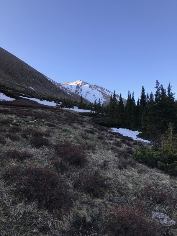
A linked pair of long and beautiful shoots off Belford's north side were mentally noticed at this time by my partner and I as we stammered through the valley in silence
Belford's North side
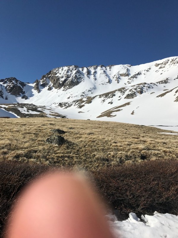
Winding our way up, our objective looked good from afar.
Missouri's North side
Shortly after the cabin, one could certainly ski the rest of the way up, we waited to transition until maybe midway through the high, low-angle valley until we were confident we could ski the entire way. At one juncture in the valley, the snow split, we went left. We could have skied the entire way had we gone right.
Below the shoots, one must gain a short shelf and we saw a rout directly below the shoots, and one to the left. Both had tracks. Is possible another rout even further to the lookers right existed. We chose the rout that afforded us to keep our skis on longer, the rout directly below the shoots. Here it was 8:15 and the snow was soft, we sank up to our bood cuffs. I began to worry we were too late.
On top of the shelf, the snow was different. It had a firm crust. My pole handle did not penetrate even with my full weight. My worry level quickly subsided.
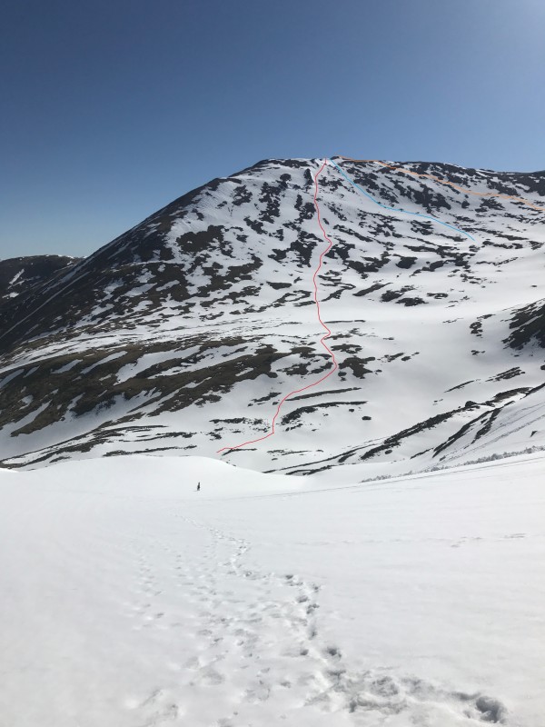
We took a long look at our options. There was avalanche debris in the area but not affecting our rout too much. We decided the main coulier was the way to go up and down because of more debirs in the C coulier.
Main Coulier on Missouri
"C" Cuolier on Missious
Approaching the main coulier, we transitions to crampons and snow tools. Then, climbing just above old tracks that diverged into each coulier, we hear the massive whomp . My partner and I, separated by 100 feet both heard and felt it. I believe phrase said at that point was "Lets get the (heck) outa here". I noted the time was exactly 9:00 and we were both somewhat perplexed considering the conditions report last week. Later we learned it had snowed 9 inches on the upper portions Thursday which may have lead to a couple of snow layer not yet binding. We skied to the valley and schemed a new plan, climb the patchwork snow on the south side of Belford to the summit.
The new plan required a long look, it was like trying to complete a maze. Several options were noticed and we headed up. Although thin, the snow was crusty and supportive. I summited around 11:00 if memory serves me correctly. Unfortunately my partner was gasses and only made it half-way up, so the option to do the NW gully was off the table for me because of that. The ski down was a delight and we made it almost all the way back to the half-cabin around 11:30. I consider the day salvaged.
Orange - Ascent, Red - Descent, Blue - Considered for ascent
Back to the car at 12:30 and took a quick dip in the raging river.
Thumbnails for uploaded photos (click to open slideshow):
Good job improvising, and persevering. FYI it's chutes and couloirs
Caution: The information contained in this report may not be accurate and should not be the only resource used in preparation for your climb. Failure to have the necessary experience, physical conditioning, supplies or equipment can result in injury or death. 14ers.com and the author(s) of this report provide no warranties, either express or implied, that the information provided is accurate or reliable. By using the information provided, you agree to indemnify and hold harmless 14ers.com and the report author(s) with respect to any claims and demands against them, including any attorney fees and expenses. Please read the 14ers.com Safety and Disclaimer pages for more information.
Please respect private property: 14ers.com supports the rights of private landowners to determine how and by whom their land will be used. In Colorado, it is your responsibility to determine if land is private and to obtain the appropriate permission before entering the property.
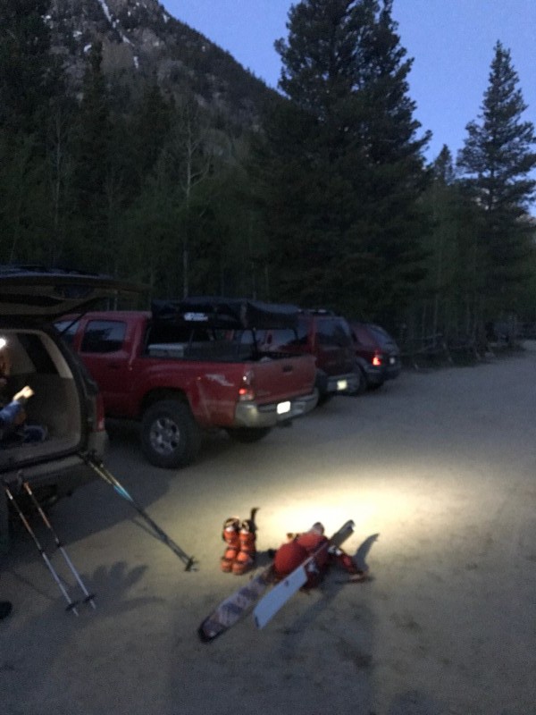


 Leaving the parking lot at 5:15, headlamps were no longer needed")
 Belford's North side")
 Missouri's North side")
 Main Coulier on Missouri")
")
 Orange - Ascent, Red - Descent, Blue - Considered for ascent")


